
Trajanopolis
Trajanopolis, one of the most important cities in Thrace on the Via Egnatia
Trajanopolis, next to the modern village of Loutros and about 16 km northeast of Alexandroupolis, was founded by the Roman emperor Trajan (98-117 AD) in the early 2nd century AD. In Byzantine times, up until its abandonment shortly after the middle of the 14th century, it became one of the most important military, administrative and ecclesiastical centres of Thrace. Trajanopolis was a station (mansio) of the Via Egnatia, between the changing stations (mutationes) of Tempyra (Timpiro or ad Unimpara) to the west, in the area of present-day Alexandroupolis, and the changing-station of Demas or Dymis to the east, 13-16 Roman miles (20-23 km) away – this places the station of Dymis in the area of the modern villages of Poros and Ardani, on the west bank of the River Evros.
Its key geographical location on the Via Egnatia was a decisive factor in the development of Trajanopolis and its emergence as one of the largest urban centres of Thrace. The north-south road from Adrianople to the sea also passed through the station of Trajanopolis. The thermal springs of Trajanopolis, a major regional attraction from ancient times, are still in use today.
History
The history of Trajanopolis is known mainly through written sources, as no systematic excavations have been carried out in the area. On the basis of sporadic finds dated before the 2nd century AD, it is thought that the city was founded on the site of a settlement of unknown name and history, which belonged to Samothracian Peraia.
The founding of Trajanopolis was part of the Emperor Trajan’s efforts to upgrade the province of Thrace and create a powerful urban centre, in whose territory all the pre-existing small settlements of the Evros plain would be united. The same emperor founded Plotinopolis (named after his wife Plotina) in the region of Thrace, while he re-founded Topeiros at the mouth of the River Nestos. Trajanopolis is first mentioned in the 2nd century AD, by the geographer Claudius Ptolemy (100-170 AD), among the inland cities of Thrace. The city issued coins, with some interruptions, from the beginning of the reign of Marcus Aurelius (161-180 AD) until the reign of Gordian III (238-244 AD). There was an active Christian community in Trajanopolis as early as the 2nd century AD, as demonstrated by the example of St Glyceria, who was born here during the reign of Emperor Antoninus Pius (138-161 AD) and later martyred in the same city. In Early Christian times, Thrace was subdivided into six provinces, with Trajanopolis being the capital of the province of Rhodope. In the 4th century AD the city became an episcopal see, while in the 5th century it became a metropolitan see, to which the most important episcopal sees of the region were subject until the mid-14th century.
During the Byzantine period, Trajanopolis was the seat of the general of the theme including the region of Thrace, initially the Theme of Macedonia (802), then the Theme of Thrace and Macedonia (976-1025) and later the Theme of Adrianople and Didymoteichon (1081-1118). In the autumn of 1077, Nikephoros Bryennios, who had rebelled against Emperor Michael VII Doukas (1071-1078), was proclaimed emperor here. In 1204, after the Sack of Constantinople, Trajanopolis passed into the hands of the Crusaders. In 1205/6, it suffered significant destruction caused by the Bulgarian ruler Kalojan (Ioannitza or “Skyloioannes”). In the first half of the 14th century and shortly after the middle of the same century, the city was repeatedly attacked by foreign raiders, including Catalans, Bulgars and Umur, the Emir of Aydın. In 1343/4, John Kantakouzenos camped near the city, which, however, he found largely destroyed. In 1347, Turkish raiders destroyed much of the city, which by the mid-14th century showed strong signs of desolation. There is no record of exactly when it was captured by the Ottomans, who completed the conquest of Thrace after the Battle of Marica (26 September 1371). The only surviving Byzantine monument of the archaeological site is a small church, which stands in ruins and probably dates from the first half of the 14th century.
In Ottoman times, the town was called Urumcik and was gradually abandoned. Only its thermal springs seem to have remained in use. In 1432-1433, when the Burgundian Bertrandon de la Broquière visited the town, he met only a few inhabitants. In the late 1670s, the Ottoman traveller Evliya Çelebi visited the springs and praised their healing properties. He states that Sultan Mehmed IV (1648-1687) had come to Trajanopolis and ranked its thermal springs among the best he had ever visited. Among the important Ottoman monuments of Traianoupolis that are not preserved today is the tekke (dervish house) of Ιşıklar or Nefes Baba,one of the largest in Thrace, It is known through its detailed description by the Ottoman traveller Evliya Çelebi. It was located on the hilltop of the acropolis of Trajanopolis, on the site of the chapel of SS Constantine and George. Its construction is dated by the English scholar Frederick William Hasluck to the second half of the 14th century, immediately after the Ottoman conquest of the region. According to the 17th-century Ottoman historian Hibrî, however, it was founded by Ekmekçi Zâde Defterdar Ahmed Pasha, who was buried in the tekke in 1591. On the site of the tekke today is the holy spring of St George, the waters of which are also considered holy by Muslims.
Museums
Fortifications and topography
The limited archaeological remains provide only scanty evidence of the topography and monuments of the city. Based on the archaeological data currently available, the acropolis was located on the hill of Agios Georgios, while the main city extended between the western foot of the hill and the present-day bed of the Tsai stream. Its enceinte, about 2 km long, was rectangular or pentagonal in shape. According to the historian Procopius, the Emperor Justinian (527-565 AD) repaired the city walls, which suggests that its fortifications predate the 6th century; they were probably constructed during the Roman era.
Outside the eastern section of the city walls, limited excavations have brought to light a small number of burials of late antiquity. Northwest of Trajanopolis is a tumulus dating from the time the city was founded (early 2nd c. AD). It contained rich grave goods which are now exhibited in the Archaeological Museum of Alexandroupolis.
The limited number of architectural elements, the inscriptions, the movable finds and the coins – some of which are now housed in the Archaeological Museum of Alexandroupolis – complete the picture of the life of the city from Roman to Byzantine times.
Hana
The most important monument in Trajanopolis today is a long, barrel-vaulted building known as the “Hana”, “Trajan’s Palace” or the “Roman Baths of Trajanopolis”, which stands in the centre of the archaeological site. The building is a han, an inn for travellers passing through the city and visitors to the thermal springs. Built around 1375-1385 by Gazi Evrenos, the Ottoman Bey who played a crucial role in the Ottoman conquest of Thrace, it is one of the earliest examples of secular Ottoman architecture in Greece. It has been argued that, after its abandonment in the mid-14th century, Trajanopolis, thanks to its location on the Via Egnatia and its thermal baths, preserved a small residential nucleus which continued to function as a station of the Via Egnatia. The building of the Hana seems to have been part of this settlement.
During the Ottoman period, the establishment of hans and caravanserais in the settlements and along the extensive road network of the empire became widespread. Hans or khans were supply stations, providing accommodation for travellers and especially for caravans, on whose transcontinental activities the economy of the Ottoman Empire largely depended. They also served as trading-stations and storage spaces. Caravanserais (kervansarays in Turkish) were larger than hans, from which they differed mainly in the provision of higher quality services. They were also used for trading and other economic activities, while in times of war they served as warehouses for supplies and military equipment. Caravanserais were usually found in thriving urban centres located at the beginning or end of major trade routes.
The Hana of Trajanopolis stands out for its elaborate cloisonné masonry, with stone blocks enclosed by bricks, and belongs to the second type of building of this category, consisting of two long, domed rooms, the front one intended for travellers and the second, at the back, for pack animals and carts – in the first type, the han is laid out around a central courtyard. In the first hall of the Hana, now almost completely destroyed, the remains of six fireplaces are preserved, confirming that it was a travellers’ hostel. The second room, which is in better condition and is almost three times the size of the first, was intended for pack animals, as the built manger along its east wall shows.


Hammam complex

EASTERN BRANCH – ANCIENT & MODERN EGNATIA
EVROS
Evros, where the ancient Via Egnatia is preserved better than anywhere else
The Regional Unit of Evros has the most and best-preserved sections of the Via Egnatia than anywhere else in Greece. The parts of the ancient Via Egnatia visible today have been preserved by the Ministry of Culture.
Some of the best-preserved sections, along a route about 5 km long, are visible in the eastern part of the Regional Unit of Evros, between the archaeological site of Trajanopolis and the village of Monastiraki. In this section, the ancient Via Egnatia runs east-west, following the foot of the hills along the modern Alexandroupolis–Kipoi highway, in order to avoid the marshes of the River Evros. The longest section, 300 m long, lies about 1.5 km before the modern village of Doriskos, where the ancient city of the same name, one of the most important in Thrace, is located at the site of Saraya, on a low hill overlooking the plain around the Evros Delta. In ancient Doriskos was found a milestone of the Via Egnatia dated to the Roman imperial period (31 BC–330 AD). It is now exhibited in the Archaeological Museum of Alexandroupolis.
A long stretch of the ancient Via Egnatia is also preserved in the western part of the Regional Unit of Evros, on the border with the Regional Unit of Rhodope, where it crosses the Zonaia Mountains, linking the plains of Alexandroupolis and Komotini. This section of the Via Egnatia follows the ancient “Royal Road” along which Xerxes’ great army moved during the Second Persian War (480 BC). It is still a marvellous example of route planning to this day, being perfectly adapted to the local terrain: it avoids sharp bends and steep gradients, which is why in some places it does not follow the shortest route, but runs along smooth ridges, avoiding the flow of water. A few metres east of the ancient Via Egnatia, the modern Egnatia Motorway and the Komotini–Alexandroupolis national highway pass through the deep gorge of Vathyrema (Karanlik Dere). Excavators were used to cut the two modern roads through the gorge, something which was not possible in ancient times.
Many of the sections of the ancient Via Egnatia in the Zonaia Mountains were not previously visible and were identified during works to highlight the road carried out by the competent Ephorate of Antiquities. In some areas, the ancient roadbed has been destroyed by the cutting of modern forest roads, which faithfully followed the route of the ancient road. An archaeological excavation 1.5 km northwest of the village of Komaros studied the particularly careful construction of the road, which is 8 m wide at this point, with a pronounced curvature of up to 8%. The roadbed is 1.20 m deep. Large stones have been placed at the edges of the road, projecting above the surface to prevent carts from slipping. A row of long stones runs down the middle of the carriageway, separating the two lanes.
The sections of the Via Egnatia in the Zonaia Mountains have been conserved and highlighted in the framework of a European Union project for the promotion of Roman roads in the Mediterranean. Today, one can walk along the mountainous route of the Via Egnatia, following the signs placed by the Ephorate of Antiquities of Evros.
Along the route of the Zonaia Mountains a series of fortified mounds have been identified, which protected the coastal positions of Samothracian Peraia. These fortified positions form an arc of mutually supported peaks which fully control the passes of the Zonaia Mountains and have an excellent view of the plains of Komotini and Alexandroupolis, and the Thracian coast.
In the plain of Alexandroupolis, in the southern foothills of the Zonaia Mountains, written sources mention a changing station (mutatio) of the Via Egnatia named Melalico, Milolito or Micolito, which is located either between the modern villages of Dikella and Mesimvria, or a little further west, near the archaeological site of Sidiropigado. It makes sense that there would be a way station here for a rest and an overnight stop before the demanding crossing of the Zonaia Mountains, where there were no supply stations.
Correspondingly, there was another station (mansio) of the Via Egnatia to the north of the Zonaia Mountains, in the plain of Komotini, called Brendice, Bricize, Brenzici or Berozicha. This station is located in the environs of the village of Aetolofos, where a milestone of the Via Egnatia has been found, dated between 235 and 238 AD.
Feres, a strong city-castle that arose around the Monastery of Panagia Kosmosoteira
The small town of Feres is located 29 km northeast of Alexandroupolis and just 4 km from the River Evros, in the middle of a fertile plain. It is one of the most historical settlements of Thrace, continuously inhabited since Byzantine times. The founding of Feres, the Byzantine Bera/Pherrai, is closely linked to the Monastery of Panagia Kosmosoteira (the “Virgin Saviour of the World”), one of the most important Byzantine monuments in Greece, of which only the katholikon (monastery church) in the town centre survives today. The history of the founding of the monastery is known from its Typikon, the set of regulations prescribing its rules of operation. The Typikon was written by the founder of the monastery himself, the Sebastokrator Isaac Komnenos, third son of Emperor Alexios I Komnenos (1081-1118) and father of Emperor Andronikos I Komnenos (1183-1185). Isaac Komnenos withdrew to Bera when he was exiled from Constantinople due to his dispute with his brother, Emperor John II (1118-1143). According to the Typikon, Isaac built the monastery katholikon in 1151/2, intending to be buried inside it. To this end, he arranged for the construction of a particularly magnificent tomb, which, however, does not survive today. For the decoration of the tomb, which is described in detail in the Typikon, Isaac would have brought here, among other things, the tomb sculptures he had already prepared in the famous Chora Monastery in Constantinople, whose katholikon he had radically repaired earlier, around 1120.
Isaac, who supervised the construction of the monastery himself, took care to reinforce it with strong fortifications, which is why the Typikon describes it as a “castle”. At the same time, he founded a new settlement around the monastery, gathering together the inhabitants of three nearby villages (Neokastron, Lykochori and Drachos). The settlement which developed around the monastery formed the core of Byzantine Bera. The choice of location for the monastery and the settlement of Bera was largely due to the great estate owned by Isaac Komnenos in the area, which included 33 large farms and villages, two small castles and a harbour. Isaac Komnenos’ sizeable estate, his aristocratic background and his high level of education contributed to the creation of an ambitious work.
Bera was strategically located very close to the cities of Trajanopolis to the east and Ainos (present-day Enez in Turkey) to the west, on the opposite bank of the Evros. It also stood at the crossroads of two major highways: the Via Egnatia, which connected Bera to the cities of Thrace and to Constantinople, and a second road leading from the Thracian coast to Adrianople. Communication with the latter was also possible via the River Evros, which was navigable until the late 19th century. According to John VI Kantakouzenos, who describes Bera as a “stronghold”, it probably had a port on the river. More specifically, the Via Egnatia passed through Bera in a southwest-northeast direction, parallel to the modern Alexandroupolis–Kipoi national highway, avoiding the marshes of the Evros Delta. Bera was located between two stations of the Via Egnatia: the changing station (mutatio) of Demas (or Dymis), which, according to the prevailing view, is located in the area of the modern villages of Poros and Ardani, west of the Evros, and the station (mansio) of Cypsela (Gypsala or Gipsila), present-day İpsala in Turkey, east of the Evros. At Cypsela, the Via Egnatia crossed the River Evros, which had an average width of 2 km, and continued on towards Constantinople.
The association of Bera with the Via Egnatia is indicated by two milestones found in the area. The first, now in the Byzantine Museum of Didymoteichon, preserves a Latin inscription referring to road repairs in the region of Thrace between 59 and 62 or 63 AD, carried out on the initiative of the Emperor Nero through the procurator Titus Julius Ustus. The second milestone, the fate of which is currently unknown, bore a Greek inscription according to which it was dedicated either by the city of Ainos or by the otherwise unattested city of Avera – depending on the reading of the last two verses of the inscription – to the Emperor Maximinus, who was of Thracian origin, and his son, Caesar Gaius Julius Verus Maximus (235-238 AD). If the reading of the second city name is correct, it may be identified with Bera.
HISTORY
Little is known about the history of the local settlements that predated the construction of the Monastery of Panagia Kosmosoteira (1151/2). The statement in the Typikon of the monastery that Isaac was its renovator suggests that there must have been an earlier monastic establishment on the site.
The written sources referring to the area up to the 13th century usually mention the “monastery in Bera”, but do not refer to the fortified settlement. From the 14th century onwards, however, when Thrace came to the forefront of the wars that shook Byzantium, references to Bera as a castle appear with increasing frequency.
About thirty years after the founding of the monastery, in late 1183 or early 1184, Emperor Andronikos I Komnenos visited the Monastery of Kosmosoteira during a hunting expedition to honour the tomb of his father, the Sebastokrator Isaac. About ten years later, Emperor Isaac II Angelos (1185-1195) was overthrown by his brother Alexios III Angelos (1195-1203) at Cypsela and captured at Makri. From there he was taken to the Monastery of Kosmosoteira, where he was blinded. This is the first time that the monastery is mentioned as a place of punishment. In the 14th century, there was another case in which the “fortress” of Bera (not the monastery) was used as a place of confinement. The two sons of the official Andronikos Asen, John and Manuel, were imprisoned here in 1335 for six years by order of Emperor Andronikos III Palaiologos (1328-1341).
In 1204, with the distribution of the territories of the Byzantine Empire by the forces of the Fourth Crusade, Bera passed into the hands of the Crusaders and from then on it would be caught up in the bloody conflicts between the Bulgars, the Ottomans and the Byzantines of the Empire of Nicaea. In 1246, the Emperor of Nicaea, John III Doukas Vatatzes, passed “near the monastery of Bera” during his victorious campaign in Macedonia and Thrace.
In the 14th century, Bera was sacked by the Bulgarian Tsar Michael Shishman (1323), and shortly afterwards (1329/30) by an army of Turks from the region of Smyrna, who landed in the Evros Delta with seventy ships and besieged Bera and Trajanopolis.
During the second civil war between John VI Kantakouzenos and the guardians of the child-emperor John V Palaiologos (1341-1347), the usurper Kantakouzenos, who had been proclaimed emperor in 1341 in Didymoteichon, established a garrison in Bera. The local inhabitants revolted against the garrison in 1342, with the support of the monks of the monastery, captured the members of the garrison and imprisoned them in the fortress before sending them to Constantinople. Kantakouzenos besieged Bera once again, but without success, thanks to the resistance of the monks and the local peasants. In 1355, Emperor John V Palaiologos regained control of Bera, but it seems that by this time the Monastery of Kosmosoteira had been abandoned and only villagers lived in the fortress.
The Ottoman invasion of Thrace with the capture of Tzympe in 1352 and Gallipoli in 1354 was followed by constant raids in the interior of Thrace and the systematic occupation of its territories. According to one view, Bera was captured in 1357 or 1358 by Süleyman Pasha, the son of Sultan Orhan (1326-1362), who demolished its walls and converted the monastery church into a mosque. It is more probable, however, that Bera was conquered by the Ottomans in 1371. In 1373, the city was captured by the Ottomans a second time. The first capture, in 1371, probably refers to the capture of the city by Ottoman irregulars, while the second, in 1373, probably refers to the victory of Murad I, who appeared in Thrace at this time after a long absence.
In Ottoman times, Bera, now named Ferecik, was a station on the left branch of the Via Egnatia (Sol Kol), with caravanserais and hans for travellers. The Burgundian traveller Bertrandon de la Broquière, who visited the town in 1432-1433, reports that it was inhabited by Greeks and Ottomans and that its beautiful castle had been partly destroyed. He also confirms that the katholikon of the Kosmosoteira had been converted into a mosque. According to an Ottoman tax register of 1454/5, the town had a caravanserai and a hammam. In the 17th century, the town developed into an important Ottoman administrative centre, in fact the most important between the River Evros and Komotini. According to the Ottoman traveller Evliya Çelebi, who visited it in the late 1670s, it was divided into seven neighbourhoods (mahalles), with the Muslim ones occupying the best, central part of the town and the Christian ones “scattered around its edges”. The town had 500 houses with beautiful gardens and vineyards, 100 shops, two hans and a considerable number of religious buildings. Each Muslim quarter had its own mosque (mescit), while the most important mosque in the city was the converted Monastery of Kosmosoteira. Among the Ottoman monuments of the city, the İbrahim Baba Tekke (dervish house), a hammam and parts of the city’s water supply network, mainly aqueducts, are still preserved today. The city’s prosperity is also evidenced by a small pottery kiln excavated 500 m east of Kosmosoteira, dating from the early years of the Ottoman conquest of the city.
Over the following centuries, the town was visited by numerous travellers. The merchants had their warehouses on the banks of the Evros, where goods arrived by water from Adrianople. Ferecik would remain an important economic and political centre until the end of the 19th century, when Alexandroupolis, with the construction of its large port and the Thessaloniki–Constantinople/Istanbul railway line, became the new economic and transport hub of the region.
Feres became part of the Greek State in 1919, along with Western Thrace. After the Treaty of Lausanne in 1923 and the exchange of populations, many refugees from Asia Minor settled in Feres.
MONUMENTS
Monastery of Panagia Kosmosoteira
Of the monastery founded by Isaac Komnenos, the katholikon is preserved in good condition today. The church is of the cross-in-square distyle type, covered by a great twelve-sided central dome, surrounded by four smaller octagonal ones. The five domes were covered from the outset with lead sheets, as the monastery Typikon stresses. The monument reflects the official architecture of 12th-century Constantinople with its typical large windows, which lend the interior a sense of grandeur, and the exclusive use of brickwork in the upper masonry of the church. Inside, the lower walls, at least in the sanctuary, were probably inlaid with marble. The floor of the church was marble, as was its sculptural decoration, of which only a few examples survive today.
Particularly notable is the fragmentarily preserved fresco decoration of the monument. The figures of the military saints stand out; they have been interpreted as symbolic portraits of specific members of the Komnene dynasty. Different views have been proposed on the dating of the wall paintings, placing them between 1152 and the early 13th century. However, according to the prevailing view, they should be dated to the first decades after 1152, immediately after the construction of the church. Their exceptional quality suggests that they were executed by a Constantinople workshop.
When the church was converted into a mosque, a minaret and some annexes were added, while at some point the original tripartite narthex and the exonarthex collapsed. The interventions of the Ottoman period included plastering over the frescoes. In order to make the plaster adhere better, the frescoes were struck with awls, and the dense pockmarks are still visible today.
The monastery was surrounded by a double enceinte, of which only a few sections survive today. The inner enclosure, referred to in the Typikon as the great enclosure, probably because it was higher, was an irregular hexagonal shape and enclosed an area of about 9,000 m2. It was reinforced at the corners with rectangular towers, of which only three are preserved. Within the great enclosure, apart from the katholikon, stood auxiliary buildings such as the refectory, the sacristy, the library and the monks’ cells.
Only a few parts of the outer enclosure, referred to in the Typikon as the sigma-shaped wall, have been found. Between the two enclosures, in accordance with the founder’s wishes, there was an infirmary.
Water supply works
In order to supply the monastery and the surrounding settlement with water, Isaac Komnenos secured the ownership of a neighbouring spring from the Metropolitan of Trajanopolis, to which the Monastery of the Panagia Kosmosoteira was ecclesiastically subject. He constructed an aqueduct to transport the water and a cistern to store it within the inner enclosure. Various isolated sections of water supply structures (aqueducts, reservoirs, water conduits, and fountains) of the Ottoman period are preserved in Feres today. The most notable is the aqueduct that bridges a ravine of the Feres stream southwest of the Monastery of the Panagia Kosmosoteira. It formed part of the water supply network that provided water to the section of the settlement that developed on this side of the monastery during the Ottoman era. The aqueduct is built using in cloisonné masonry and preserves two pointed arches made entirely of bricks. According to the prevailing view, it dates from the 15th or 16th century and was probably part of the high-arched aqueduct that supplied water to all the fountains and mosques of the town, as described by Evliya Çelebi.
A different water supply network was served by the imposing 18th-century aqueduct which spans the steep banks of the same stream, north of the first aqueduct, near the modern Alexandroupolis–Kipoi hational highway, close to the northern entrance of Feres. It was built using rubble masonry and is estimated to have originally been about 80 m long, featuring five or six arches. Today, two arches are preserved: a large pointed one 4.70 m high with a span of 7.65 m, and a smaller semicircular arch.
Ottoman Hammam (Makras Gefyra St.)
The small hammam, in a rather poor condition, is located on Makras Gefyras Street, east of the Monastery of the Panagia Kosmosoteira. It consists of an elongated rectangular entrance hall covered by a hemispherical dome and two square main chambers (hot rooms) covered with low domes. This is one of the oldest hammams in Greece, as its construction – based on its architectural and morphological characteristics – is dated before the tax register of 1454/5, which mentions the existence of a hammam in Feres.
İbrahim Baba Tekke (between Riga Feraiou and Agia Paraskevi Streets)
The single-room, square tekke (dervish house), measuring approximately 6.50 x 6.50 m, is covered by a low dome and is located northeast of the Monastery of the Panagia Kosmosoteira. Based on a now-lost inscription, it is dated to 1686.
Watermill
The watermill, which was abandoned after 1944, was used for grinding cereals and is preserved north of Feres, very close to the 18th-century aqueduct. It was constructed in the 19th century. The structure consists of a main, slightly irregularly shaped room measuring approximately 6.10 x 4.60 m, where the machinery was installed, and a smaller rectangular auxiliary space. A system of two water channels and a reservoir directed the rushing waters collected from the Feres stream and the nearby hill of Agia Paraskeve to the iron waterwheel.
MUSEUM
Folklore and Historical Museum of Feres (2 Paleologou Konstantinou St.)
Located a short distance from the Monastery of the Panagia Kosmosoteira, the museum is housed in a restored two-storey 19th-century building. Through a rich collection, including a large number of objects complemented by archival material such as old books, documents, and photographs, it showcases various aspects of the life of the region’s inhabitants.
Trajanopolis, one of the most important cities in Thrace on the Via Egnatia
Trajanopolis, next to the modern village of Loutros and about 16 km northeast of Alexandroupolis, was founded by the Roman emperor Trajan (98-117 AD) in the early 2nd century AD. In Byzantine times, up until its abandonment shortly after the middle of the 14th century, it became one of the most important military, administrative and ecclesiastical centres of Thrace. Trajanopolis was a station (mansio) of the Via Egnatia, between the changing stations (mutationes) of Tempyra (Timpiro or ad Unimpara) to the west, in the area of present-day Alexandroupolis, and the changing-station of Demas or Dymis to the east, 13-16 Roman miles (20-23 km) away – this places the station of Dymis in the area of the modern villages of Poros and Ardani, on the west bank of the River Evros.
Its key geographical location on the Via Egnatia was a decisive factor in the development of Trajanopolis and its emergence as one of the largest urban centres of Thrace. The north-south road from Adrianople to the sea also passed through the station of Trajanopolis. The thermal springs of Trajanopolis, a major regional attraction from ancient times, are still in use today.
HISTORY
The history of Trajanopolis is known mainly through written sources, as no systematic excavations have been carried out in the area. On the basis of sporadic finds dated before the 2nd century AD, it is thought that the city was founded on the site of a settlement of unknown name and history, which belonged to Samothracian Peraia.
The founding of Trajanopolis was part of the Emperor Trajan’s efforts to upgrade the province of Thrace and create a powerful urban centre, in whose territory all the pre-existing small settlements of the Evros plain would be united. The same emperor founded Plotinopolis (named after his wife Plotina) in the region of Thrace, while he re-founded Topeiros at the mouth of the River Nestos. Trajanopolis is first mentioned in the 2nd century AD, by the geographer Claudius Ptolemy (100-170 AD), among the inland cities of Thrace. The city issued coins, with some interruptions, from the beginning of the reign of Marcus Aurelius (161-180 AD) until the reign of Gordian III (238-244 AD). There was an active Christian community in Trajanopolis as early as the 2nd century AD, as demonstrated by the example of St Glyceria, who was born here during the reign of Emperor Antoninus Pius (138-161 AD) and later martyred in the same city. In Early Christian times, Thrace was subdivided into six provinces, with Trajanopolis being the capital of the province of Rhodope. In the 4th century AD the city became an episcopal see, while in the 5th century it became a metropolitan see, to which the most important episcopal sees of the region were subject until the mid-14th century.
During the Byzantine period, Trajanopolis was the seat of the general of the theme including the region of Thrace, initially the Theme of Macedonia (802), then the Theme of Thrace and Macedonia (976-1025) and later the Theme of Adrianople and Didymoteichon (1081-1118). In the autumn of 1077, Nikephoros Bryennios, who had rebelled against Emperor Michael VII Doukas (1071-1078), was proclaimed emperor here. In 1204, after the Sack of Constantinople, Trajanopolis passed into the hands of the Crusaders. In 1205/6, it suffered significant destruction caused by the Bulgarian ruler Kalojan (Ioannitza or “Skyloioannes”). In the first half of the 14th century and shortly after the middle of the same century, the city was repeatedly attacked by foreign raiders, including Catalans, Bulgars and Umur, the Emir of Aydın. In 1343/4, John Kantakouzenos camped near the city, which, however, he found largely destroyed. In 1347, Turkish raiders destroyed much of the city, which by the mid-14th century showed strong signs of desolation. There is no record of exactly when it was captured by the Ottomans, who completed the conquest of Thrace after the Battle of Marica (26 September 1371). The only surviving Byzantine monument of the archaeological site is a small church, which stands in ruins and probably dates from the first half of the 14th century.
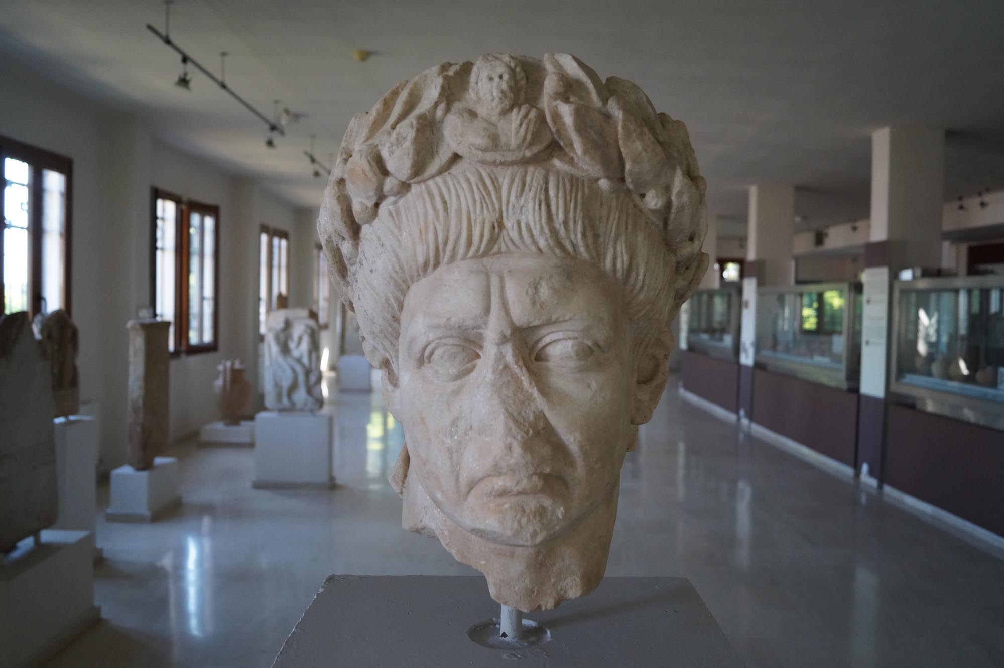
In Ottoman times, the town was called Urumcik and was gradually abandoned. Only its thermal springs seem to have remained in use. In 1432-1433, when the Burgundian Bertrandon de la Broquière visited the town, he met only a few inhabitants. In the late 1670s, the Ottoman traveller Evliya Çelebi visited the springs and praised their healing properties. He states that Sultan Mehmed IV (1648-1687) had come to Trajanopolis and ranked its thermal springs among the best he had ever visited. Among the important Ottoman monuments of Traianoupolis that are not preserved today is the tekke (dervish house) of Ιşıklar or Nefes Baba,one of the largest in Thrace, It is known through its detailed description by the Ottoman traveller Evliya Çelebi. It was located on the hilltop of the acropolis of Trajanopolis, on the site of the chapel of SS Constantine and George. Its construction is dated by the English scholar Frederick William Hasluck to the second half of the 14th century, immediately after the Ottoman conquest of the region. According to the 17th-century Ottoman historian Hibrî, however, it was founded by Ekmekçi Zâde Defterdar Ahmed Pasha, who was buried in the tekke in 1591. On the site of the tekke today is the holy spring of St George, the waters of which are also considered holy by Muslims.
MONUMENTS – ANTIQUITIES
Fortifications and topography
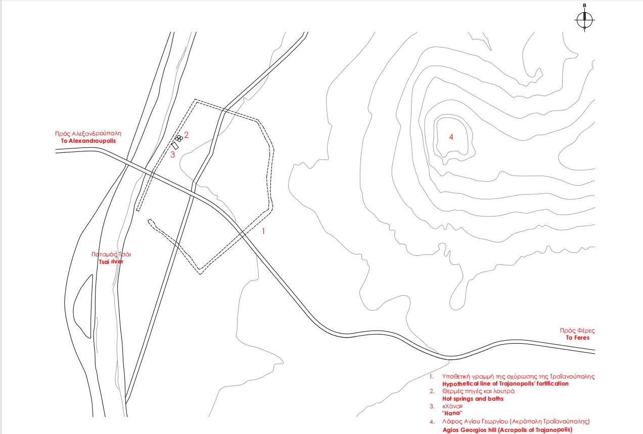
The limited archaeological remains provide only scanty evidence of the topography and monuments of the city. Based on the archaeological data currently available, the acropolis was located on the hill of Agios Georgios, while the main city extended between the western foot of the hill and the present-day bed of the Tsai stream. Its enceinte, about 2 km long, was rectangular or pentagonal in shape. According to the historian Procopius, the Emperor Justinian (527-565 AD) repaired the city walls, which suggests that its fortifications predate the 6th century; they were probably constructed during the Roman era.
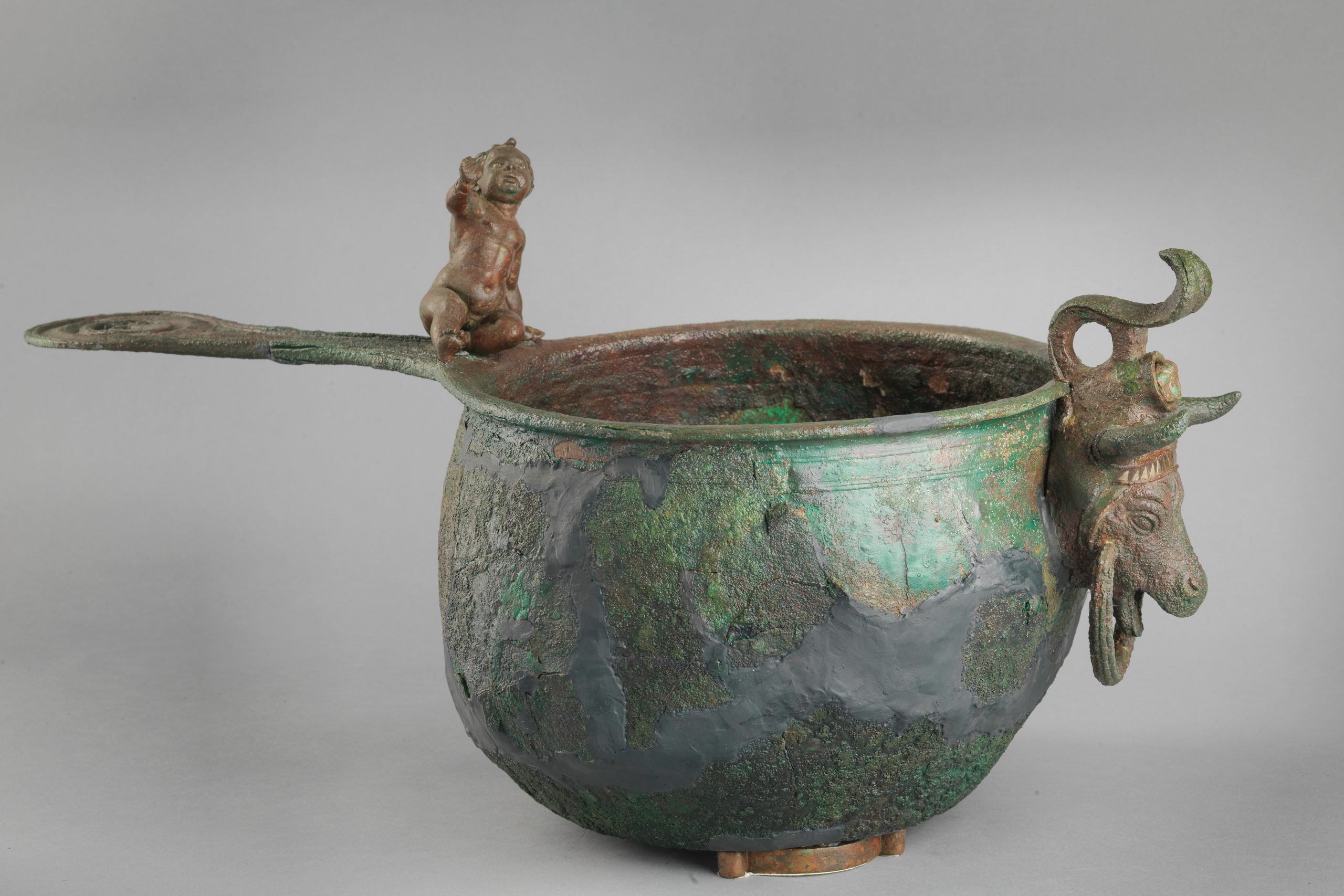
Outside the eastern section of the city walls, limited excavations have brought to light a small number of burials of late antiquity. Northwest of Trajanopolis is a tumulus dating from the time the city was founded (early 2nd c. AD). It contained rich grave goods which are now exhibited in the Archaeological Museum of Alexandroupolis.
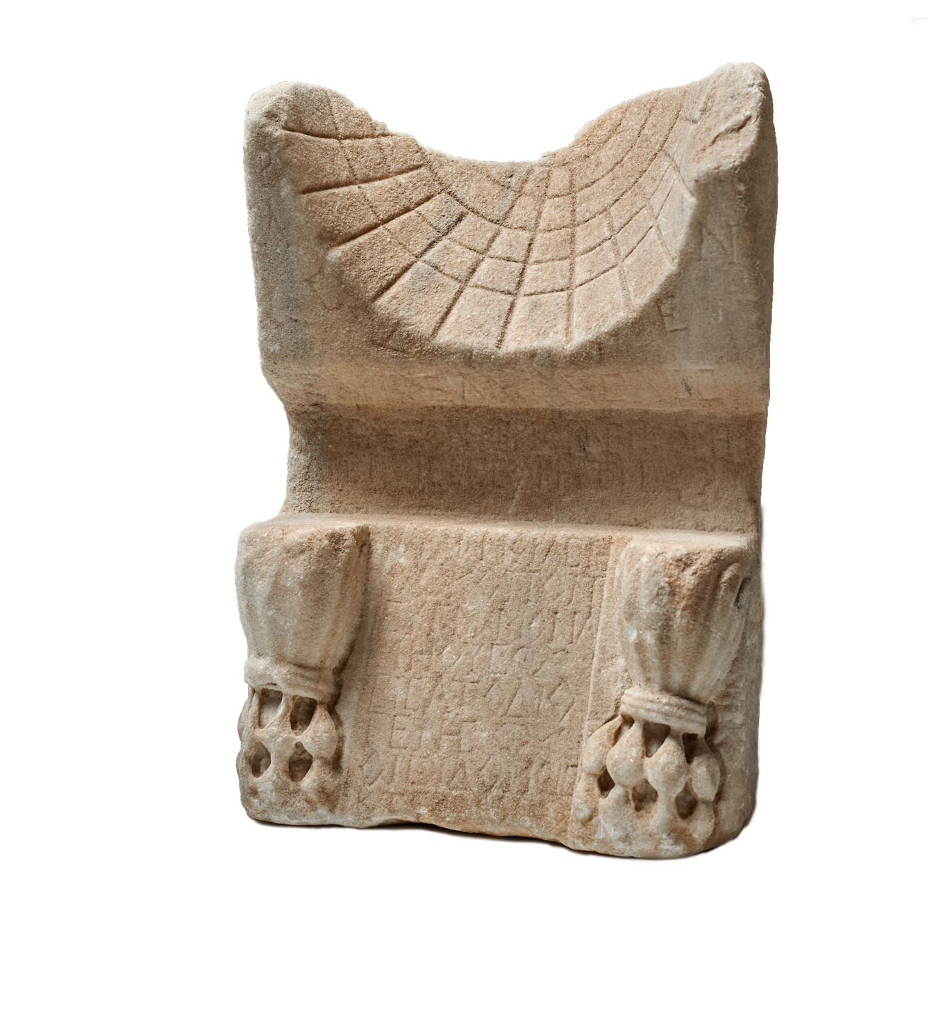
The limited number of architectural elements, the inscriptions, the movable finds and the coins – some of which are now housed in the Archaeological Museum of Alexandroupolis – complete the picture of the life of the city from Roman to Byzantine times.
Hana
The most important monument in Trajanopolis today is a long, barrel-vaulted building known as the “Hana”, “Trajan’s Palace” or the “Roman Baths of Trajanopolis”, which stands in the centre of the archaeological site. The building is a han, an inn for travellers passing through the city and visitors to the thermal springs. Built around 1375-1385 by Gazi Evrenos, the Ottoman Bey who played a crucial role in the Ottoman conquest of Thrace, it is one of the earliest examples of secular Ottoman architecture in Greece. It has been argued that, after its abandonment in the mid-14th century, Trajanopolis, thanks to its location on the Via Egnatia and its thermal baths, preserved a small residential nucleus which continued to function as a station of the Via Egnatia. The building of the Hana seems to have been part of this settlement.
During the Ottoman period, the establishment of hans and caravanserais in the settlements and along the extensive road network of the empire became widespread. Hans or khans were supply stations, providing accommodation for travellers and especially for caravans, on whose transcontinental activities the economy of the Ottoman Empire largely depended. They also served as trading-stations and storage spaces. Caravanserais (kervansarays in Turkish) were larger than hans, from which they differed mainly in the provision of higher quality services. They were also used for trading and other economic activities, while in times of war they served as warehouses for supplies and military equipment. Caravanserais were usually found in thriving urban centres located at the beginning or end of major trade routes.
The Hana of Trajanopolis stands out for its elaborate cloisonné masonry, with stone blocks enclosed by bricks, and belongs to the second type of building of this category, consisting of two long, domed rooms, the front one intended for travellers and the second, at the back, for pack animals and carts – in the first type, the han is laid out around a central courtyard. In the first hall of the Hana, now almost completely destroyed, the remains of six fireplaces are preserved, confirming that it was a travellers’ hostel. The second room, which is in better condition and is almost three times the size of the first, was intended for pack animals, as the built manger along its east wall shows.
Hammam complex
Next to the Hana and the modern church of the local saint Glykeria are two domed hammams. The older one was built between 1485 and 1497 by the Albanian general Koca Davud Pasha, Grand Vizier under Sultan Bayezid II (1481-1512), while the newer dates from the late 18th or early 19th century. At the turn of the 20th century, the hammams were joined with the addition of an auxiliary building between the two. In the second half of the 20th century, new bathing facilities and hotels were built on the site.
Avantas, the Evros village with many antiquities
Approximately 11 km from Alexandoupolis, to the north of the Egnatia Motorway, is the village of Avantas. Nearby are a number of antiquities, demonstrating the importance of the area from Roman at least until Ottoman times.
Castles of Avantas and Potamos
The two castles, built very close together, effectively controlled the mountain passes through the southeastern foothills of the Rhodope range, connecting the Evros plain with the plain of Komotini, and the coast with the hinterland of Thrace. According to the Ottoman historian and geographer Haci Kalfa, a high-ranking administrative official under Sultans Murad IV (1623-1640), Ibrahim I (1640-1648) and Mehmed IV (1648-1687), the local mountain passes were used in Ottoman times by people travelling on foot to the small town of Şapsçılar (present-day Sapes). Those who had wheeled vehicles, however, followed the road to the south of Avantas, which passed through the village of Makri, a station of the Via Egnatia.
The first castle stands on the steep Boz-Tepe Hill just north of Avantas. It is a non-rectangular parallelogram shape and encloses an area of just under a hectare. Its enceinte is reinforced by four-sided towers, four of which are visible today.
The second castle, known as the Castle of Potamos, is located south of Avantas, on the long, low, rocky hill near the Potamos railway station on the Komotini–Alexandoupolis line, close to the abandoned village of Potamos (Bulgarian Badoma), which was inhabited by Bulgarians before the region’s incorporation into the Greek State in 1920. The Alexandoupolis–Avantas provincial road passes west of the castle. The castle has a perimeter about 600 m long and encloses an area of no more than 8,000 m2. It has two fortified enclosures: the smaller, triangular inner one, with an area of about 1,000 m2, is in the north part of the castle, higher up the rocky hill. The castle’s defences are reinforced at intervals by strong towers, four-sided except for one which is trapezoidal. The castle gate, on the south side of the outer enclosure, is protected by two towers, one quadrilateral and one heptagonal. The largest tower, on the west side of the inner enclosure, may be the castle keep due to its position and size.
The lack of inscriptions or written references to the two castles prevents us from determining the year of their foundation or whether they were built at the same time. At least two building phases can be identified in the Castle of Potamos. Based on the features of the two castles, it has been suggested that they date from the 14th century, before the Ottoman conquest of the region; the conquest of Thrace was completed in 1373, after their victory against the Serbs at the Battle of Marica (1371). The few pottery sherds recovered from the two castles belong to the late 13th and the 14th century.
It has been suggested that the Castle of Potamos may be the Güvercinlik (meaning “dovecote” in Turkish) mentioned in the epic of Umur, the Emir of Aydın. If this is true, then it may be identified with the Castle of Peristeria (meaning “dovecote” in Greek), mentioned by Byzantine sources a short distance west of Bera (present-day Feres). The castle seems to have already been abandoned by the 15th century, according to the Burgundian traveller Bertrandon de la Broquière, who visited it during his voyage in 1432-1433. In the 17th century it remained deserted and ruined, “the only visitors being the local sheep and goats”, according to the account of the Ottoman traveller Evliya Çelebi, who visited the nearby village of Güvercinlik in the late 1670s.
Antiquities in the Potamos area
During work on the construction of the Trans-Adriatic Pipeline (TAP), which was completed in 2019, the remains of a large three-aisled Εarly Βyzantine basilica with a narthex and a spacious atrium were uncovered 1,700 m southwest of the Castle of Potamos. Outside the narthex and the atrium, architectural remains have come to light which, based on the movable finds and coins, belong to the Roman period. The basilica was in use until the third quarter of the 6th century AD, when it was destroyed, probably by fire. Just a few metres southeast of the basilica, an unlooted cist grave of the 2nd or 3rd century AD was found, with particularly rich grave goods which are now on display in the Archaeological Museum of Alexandoupolis. A number of architectural remains were uncovered in the wider area, indicating that both the basilica and the grave were part of a fortification and settlement complex that was in use from Roman to Early Christian times.
Cave Church of the Saints Theodore
The church is located in a narrow valley between high cliffs, 4 km west of Avantas and a few km northwest of the Castle of Potamos, almost next to the Alexandoupolis–Komotini railway line. There are caves in the rocks of the valley, at least one of which was inhabited at some point, indicating that the area was used by ascetics in Byzantine times and that the Church of the Saints Theodore was a hermitage.
A long, narrow corridor leads to the main church in the cave, a spacious, roughly rectangular chamber measuring 5 x 3.5 m. The sanctuary is delimited by a built templon.
Inside the church of the Saints Theodore are preserved frescoes which, although fragmentary, are of remarkable quality. The images do not follow the established iconographic programme of Byzantine churches, but are randomly arranged and unconnected, with the exception of the scenes in the sanctuary and on the built templon. The emphasis on scenes associated with the figure of the Theotokos (the Mother of God) suggests that the cave was originally dedicated to the Virgin rather than the Saints Theodore. Three layers of paintings can be discerned, the first of which is found on a small surface on the south side of the built templon and probably dates to the 9th-10th centuries. The scenes of the second layer are also limited; the best preserved is the Dormition of the Virgin, dating from the late 11th or early 12th century. The third and more extensively preserved layer is dated, on the basis of stylistic criteria, to the third quarter of the 13th century. Images such as the Great Deesis on the templon or the enthroned Theotokos between two archangels on the north wall attest that the workshop that painted the frescoes of the third layer in this inaccessible mountainous region of Rhodope was familiar with the artistic trends prevailing in Constantinople at the time.
Alexandroupolis, the city founded in the 19th century
Alexandroupolis, now the capital of the Regional Unit of Evros and the most populous city in the Region of Eastern Macedonia and Thrace, has an unusual history for a Greek city, as it was only founded in the second half of the 19th century.
The archaeological evidence indicates that in antiquity the site of Alexandroupolis was occupied by the ancient city of Tempyra, which was probably founded by colonists from Samothrace, making it one of the cities of the opposite Thracian coast, known as Samothracian Peraia. The Roman itineraries mention a station (mutatio) of the Via Egnatia called Tempyra (Timpiro or mutatio ad Unimpara), 8 or 9 Roman miles (12 or 14 km) from the previous station of Trajanopolis. This corresponds to the distance between present-day Alexandroupolis and the archaeological site of Trajanopolis, supporting the identification of the site with ancient Tempyra. However, there is also the view that the site of Alexandroupolis was occupied by ancient Sale, also a colony of Samothrace.
HISTORY
The archaeological evidence for the existence of a settlement on the site of present-day Alexandroupolis in ancient times is extremely limited. Occasional finds from excavations carried out in the city are dated to Classical and Hellenistic times. Parts of an organised cemetery of the Roman period have been excavated in the area of the Lighthouse and the Port Authority. On the northern edge of the city, in the Kallithea neighbourhood, the remains of a bath of the Roman period have been uncovered, while at the eastern end of the city a burial tumulus of Late Roman times was excavated by the Bulgarians during the Balkan Wars.
It was to be many centuries before the area of Alexandroupolis returned to the forefront of events. In the second half of the 19th century, the Ottoman Empire attempted to modernise and transform itself from a theocratic regime into a modern Western-style state, launching an ambitious infrastructure programme, which included the construction of railways, ports and lighthouses by European companies with the necessary expertise. Dedeağaç, as Alexandroupolis was named until 1920, was founded as part of these efforts. In 1869, the Austrian company of Baron Maurice de Hirsch was accorded the privilege by the Ottoman government of constructing and operating the railway line between Thessaloniki and Constantinople/Istanbul, the Jonction Salonique–Constantinople, while also undertaking to build a commercial port in Ainos. Ainos (present-day Enez in Turkey), at the mouth of the River Evros, had been until then the port of Adrianople, with which it communicated via the river, which was then navigable. The Ottoman government intended to connect Ainos with Adrianople by rail to facilitate the export of the products of the rich Thracian hinterland. However, the constant silting of the River Evros made it difficult to build the port facilities, and the company sought and obtained the consent of the Ottoman government to establish a port west of the Evros, in the area of present-day Alexandroupolis.
In 1872 the port works began and in 1873 the Adrianople–Dedeağaç railway line was opened. The new town began to arise around the station, with the first buildings necessary for its operation: warehouses, a customs house, and residential buildings for the European engineers and the railway workers and staff. Gradually Ainos began to decline and its Greek inhabitants moved en masse to the newly founded city, the new centre of the export trade of Thrace.
At the end of the Russo-Turkish war (1877-1878), the city was occupied by Russia. The Russians, to whom the modern grid plan of the city is due, in collaboration mainly with Greeks, drew up an urban plan (1878) in an attempt to expand the city “in a new European style”, with long, straight streets, avenues, squares and “magnificent views of the sea”. The city continued to grow rapidly after its recovery by the Ottomans. The port became very busy and the famous Lighthouse was built. At the end of the 19th century, products worth 61 million francs were being exported from Dedeağaç, compared with products worth 45.5 million francs exported from Constantinople/Istanbul and 29 million francs from Thessaloniki. Ιn 1896 a branch of the Thessaloniki–Constantinople/Istanbul railway line arrived in Dedeağaç, making the town part of a second railway axis. The sizeable commercial traffic of the town led to its rapid economic and cultural growth. Branches of banks, insurance and shipping companies were opened, while schools, churches and administrative buildings were established. In the late 19th century, Alexandroupolis was a cosmopolitan city, inhabited by Greeks, Ottomans, Armenians, Jews and Europeans, who constructed religious buildings and schools, to meet their religious and educational needs. The Greek Community, immediately after settling in the town, built a small church and a school. In 1887 it had an Urban School for Boys, a Girls’ School and a nursery school. The gradual demographic and economic growth of the Greek Community of the city, combined with the abandonment of Ainos, led in 1890 to the transfer of the metropolitan seat from Ainos to Dedeağaç. Europeans (“Franco-Levantines”) settled in the city, mainly railway and consulate employees, but also merchants and businessmen, giving the city a European air.
During the Balkan Wars (1912-1913), on 8 November 1912, Dedeağaç came under Bulgarian rule, and under the Treaty of Bucharest (10 August 1913) it was ceded to Bulgaria along with the rest of Western Thrace. After the end of the First World War and the signing of the Treaty of Neuilly (27 November 1919), Bulgaria relinquished its sovereign rights over Western Thrace and the city was placed under joint Allied administration, headed by the French and a Greek government representative, Charisios Vamvakas, a close associate of Eleftherios Venizelos (Inter-Allied Thrace Administration). On 14 May 1920, Greek Army forces, led by General Konstantinos Mazarakis-Ainian, raised the Greek flag at the city’s Government House. The discussion about the renaming of the city began immediately and the name Neapolis (“New City”) was proposed. In July 1920, King Alexander I of Greece visited the city and the local authorities decided to name it after him. Under the Treaty of Sèvres (28 July 1920), Alexandroupolis became part of the Greek State. After the Asia Minor Catastrophe (1922) and the exchange of populations, the population of the city increased significantly, with the influx of 8,000 refugees from Northern and Eastern Thrace, Asia Minor and the Black Sea. After 1920, the first elected municipal authority tried to solve many of the city’s problems. Water supply, electric lighting, telecommunications and roads were the main priorities for the modernisation of the city, which had grown impressively in the meantime, with large blocks of buildings.
The urban and economic development of Alexandroupolis continued until 1940, when it was interrupted by the Second World War, during which the city was occupied by the Bulgarians for three years (1941-1944). The end of the war marked the beginning of the city’s recovery. After 1950, Alexandroupolis followed the course of other Greek urban centres, with its economy booming, blocks of flats replacing its beautiful Neoclassical buildings, and the city itself expanding both horizontally and vertically.
MONUMENTS
Lighthouse
The monument, the symbol of the city, began to be built around 1850 by the French Administration Générale des Phares de l’Empire Ottoman. It was inaugurated on 1 June 1880 and has been in continuous operation ever since. The lighthouse is one of the tallest in the Eastern Mediterranean, at 18 m high. Its light can be seen from a distance of 24 nautical miles (about 44 km). It was oil-powered until 1973, when it was converted to electricity.
Metropolitan Church of St Nicholas (Mitropoleos Square)
The magnificent cathedral in the heart of the city, dedicated to the patron saint of Alexandroupolis, was founded in 1892 and consecrated in 1901, replacing the old, small wooden church that had been built around 1860. On 15 May 1920, the official thanksgiving service for the liberation of the city was held here. In the church of St Nicholas is the wood-carved icon of Panagia Triphotissa, dated to the late 13th century, which was brought to the city by refugees from Ainos.
Armenian church (junction of Anatolikis Thrakis and 14th Maiou Streets)
To serve the religious needs of the Armenians of the city, the Church of St John the Baptist (Surp Hovannou Garabet) was built in 1886. It is the oldest surviving Christian church in Alexandroupolis.
Catholic Church of St Joseph and Bishop’s Palace (junction of Eleftherios Venizelos and Komninon Streets)
The Church of St Joseph, the only Catholic church in Western Thrace, began to be built in 1896 as a three-aisled basilica and was completed in 1901. It stands out for its elaborate stonework and the large colonnades of green marble inside. To the same period is dated the adjacent two-storey Bishop’s Palace, which was used as the residence of the Catholic priest and the bishop’s palace of the city’s Catholic community.
Mosque (junction of Emporiou and Kassandras Streets)
To the east of Mitropoleos Square, near the port, is the Muslim mosque, one of the oldest surviving religious buildings in the city, dating from the late 19th – early 20th century.
Railway Station Buildings
A living part of the city’s history are the surviving buildings of its two railway stations, on the Adrianople–Dedeağaç (1873) and Thessaloniki–Alexandroupolis (1895) railway lines, which today house services of the Hellenic Railways Organisation or are used by the Municipality. The two-storey main building of the French Station (1873), built of brickwork and covered externally with wooden panelling, stands out in the east of the city near the port. Slightly further away is one of the most beautiful buildings of the city, the “Military Station” (Gare Militaire), which is associated with the second railway line (1895). It is built in the architectural style of Alpine stations, with impressive use of wooden decorative elements on its main façade.
Public buildings and mansions
Alexandroupolis boasts a rich architectural heritage and a significant number of public buildings and pre-war mansions that are closely tied to its historical memory. One of the most recognisable buildings in the city is the “Kapnomagazo” (Tobacco Warehouse), which today, after its renovation, houses the Municipal Library (46 Ainou St.). It was built in the late 19th century as a Catholic school and was used after 1924 for storing and processing tobacco, hence its name. One of the most imposing buildings of the city is the Zarifeios Pedagogical Academy, whose construction was begun in the late 19th century by the Ottoman authorities, possibly as a naval or military academy. It was completed after 1928 thanks to a donation from the Constantinopolitan national benefactor Georgios Zarifis (today’s 1st Experimental Primary School, 5 Georgiou Zarifi St.). The Leontarideios Urban School for Boys, in Mitropoleos Square next to the Μetropolitan Church of St. Nicholas, was erected in 1909 at the expense of the Maroneian merchant Antonis Leontarides; it operated until 1972 as a High School (today it houses the Ecclesiastical Museum). Among the city’s most notable buildings are also the port warehouses, the Old Hospital (now the Music School of Alexandroupolis), the 1st and 3rd Primary Schools, the old building of the National Bank of Greece (now housing the Democritus University of Thrace), the Courthouse, the Post Office, the mansion built by Georgios Delimichalis (today’s Municipal Conservatory), and the “House of Antoinette” (how housing the Greek-French Friendship Association). An industrial building of particular architectural significance is the Masouras Mill, built between 1930 and 1933 to process grain from the Thracian hinterland.
MUSEUMS
Archaeological Museum of Alexandroupolis (44 Makris St.)
The Museum was inaugurated in 2022 and houses finds from excavations and surface surveys in the Regional Unit of Evros, covering a wide chronological range from prehistoric to Roman times. On display here is the milestone of the Via Egnatia which was found in the village of Doriskos.
Ecclesiastical Museum of the Holy Metropolis of Alexandroupolis (18 Ainou St.)
The Museum houses a large number of exhibits, mainly heirlooms brought by refugees from Eastern Thrace.
Ethnological Museum of Thrace (63, 14th Maiou St.)
Housed in one of the most beautiful Neoclassical houses of the city (1899), the Ethnological Museum is full of folk treasures collected from various parts of Thrace.
Historical Museum of Alexandroupolis (335 Dimokratias avenue)
The history of the city of Alexandroupolis and the wider region is presented through a modern museological and museographical approach. The museum also includes the collection of the folklorist Eleni Filippidi, showcasing the life of Sarakatsani women in Thrace.
Folklore Museum of the Cappadocian Estia (1 Mitropoulou St.)
The museum, housed in the building of the Cappadocian Cultural Association of Evros Prefecture “The Three Hierarchs”, takes visitors on a journey into the atmosphere of everyday life in the villages of Cappadocia, through a rich collection of heirlooms and artifacts.
Natural History Museum of Alexandroupolis (Platanotopos, village of Maistros)
The museum, housed in a modern building perfectly integrated into the lush green surroundings of the small community of Maistros, just east of Alexandroupolis, showcases the rich biodiversity and unique ecosystems of the Evros region.
Makri, a Byzantine castle-city with a “prehistory”
Eleven km west of Alexandroupolis is the community of Makri, one of the most important castle-cities of Thrace during the Byzantine period. In the port of today’s village, the small harbour of Platanos, is the “Cave of the Cyclops”, where, according to local folklore, lived the one-eyed Cyclops Polyphemus, whom Odysseus intoxicated with wine before blinding him. Very close to the cave, on a natural rocky outcrop, a large prehistoric tumulus was discovered when the Bulgarians dug trenches here during the First World War. The tumulus at the site known as Toumba (which actually means “tumulus”) covers an area of 1 hectare. One of the most important Neolithic settlements in the Balkans arose here from 6200 BC onwards, lasting for about a thousand years. The Neolithic settlement was succeeded during the Classical and Hellenistic periods by a small trading post, covering an area of 1,500 m2, which remained in use from the 5th to the 2nd century BC, mainly serving the local trade in wine, olive oil and pottery. During the Roman imperial period (31 BC-330 AD), the settlement was more active, with no changes in the buildings except for the construction of a large retaining wall about 40 m long. The tumulus was in continuous use until Byzantine times, as 11th-century burials have come to light, suggesting that it served as the cemetery of the neighbouring Byzantine Makri. The important movable excavation finds are displayed in the Archaeological Museum of Alexandroupolis.
Scholars formerly believed that the tumulus of Makri was the site of Orthagoria or one of the three of the six colony-cities of Samothracian Peraia (Mesembria, Zone or Dryn). More recent studies, however, have shown that the sources indicate that it is actually Sale, another of the colonies founded by Greeks from Samothrace. In Roman times, Sale was a supply station (mutatio) of the Via Egnatia, according to itineraria which mention the Sale station 7 miles from the Tempyra (Timpiro or ad Unimpara) mutatio. The latter, according to the prevailing view, was located on the site of modern Alexandroupolis. The distance of 7 miles does indeed correspond to the distance of 11 km between Makri and Alexandroupolis. This view is supported by the growth of the Toumba settlement in the Roman imperial period, probably due to the operation of the Via Egnatia, of which it was a station.
In Byzantine times, the castle-city of Makri, just a few metres north of the mound, seems to have remained a station of the Via Egnatia. The establishment of a station there is justified by its key geographical position behind the Zonaia Mountains, which separate the plain of Komotini from that of the River Evros.
HISTORY
Ancient Sale is mentioned in written sources from the 5th century BC to the 4th century AD. In the early 2nd century BC, it is referred to as a village that had passed into the sphere of influence of Maroneia. On the founding of Trajanopolis in the early 2nd century AD, it was probably incorporated as a town in the territory of that neighbouring city. The remains of the Classical and Roman periods that have come to light so far are limited and are located only at the site of Toumba or the “Cave of the Cyclops”.
From the 9th century onwards, Makri appears to be an important castle-city, an episcopal see subject to the metropolitan see of Trajanopolis, while during the Byzantine Civil War (1341-1347) it became a metropolitan see itself.
In 1195, Emperor Isaac II Angelos (1185-1195) was captured in Makri by the forces of his rebellious brother, the future Emperor Alexios III Komnenos (1195-1203). He was taken to the nearby Monastery of Panagia Kosmosoteira in Bera (present-day Feres), where he was blinded. In 1204, Makri fell to the Crusaders, while in 1205/6, like many other cities of Thrace, it suffered from the devastating raids of the Bulgarian ruler Kalojan (Ioannitza or “Skyloioannes”). However, Makri continued to exist and even prosper.
There is no information on the conquest of Makri by the Ottomans. According to the Ottoman traveller Evliya Çelebi, the city was captured by the Ottoman Bey Gazi Evrenos. It is known that the metropolitan bishop of the city was facing difficulties due to the Ottoman raids as early as 1361. The conquest of the cities of Thrace by the Ottomans to the west of Koumoutzena (Komotini) was completed by 1373.
In Ottoman times, the city was renamed Megri and expanded outside the walls. According to the Burgundian traveller Bertrandon de la Broquière, who visited the city in 1432-1433, it showed signs of decline and was inhabited by “Greeks and Ottomans”. The city was described by Evliya Çelebi, who came here in the late 1670s. At that time, Makri consisted of about 200 houses, 150 of which belonged to Christians and the rest to Muslims. The latter lived in the varosi, the quarter outside the walls. The city had a considerable number of secular and religious buildings, including five hans (inns) for travellers and a public hammam. The main economic activity of the city was trade, followed by fishing, agriculture and olive oil production.
In the early modern period (6 April 1835), the Five Holy Neomartyrs, Manuel Palogoudas, Theodore Demetriou, George Kourounis and George Kalakikos of Samothrace and Michael of Cyprus, were martyred in Makri by the Ottomans. Their relics are housed in both Makri and Samothrace.
MONUMENTS AND ANTIQUITIES
The remnants of a significant number of Byzantine and Ottoman monuments are preserved today in Makri.
Fortifications
The Byzantine castle of the town, of which only a few parts survive today, was in good condition until the middle of the 17th century, when Evliya Çelebi visited the area. The enceinte, dated to the 9th-10th centuries, is around 400 m long. There was a round tower in each of the four corners of the wall, while the defences were reinforced by four- and five-sided towers at regular intervals.
Remains of an Ottoman mosque and a Byzantine church
Within the Byzantine wall, next to the Church of St Anastasia, are the remains of a Muslim mosque that was built at the beginning of the 20th century. The excavation has revealed the large, rectangular central hall of the mosque and the revak (porch) along its north side. The mosque was founded on the ruins of a 10th-century three-aisled basilica, which is thought to have been the city’s episcopal church. Following the destruction of the basilica in the Late Byzantine period, the site was used as a cemetery. Later, in the Ottoman period, warehouses were built against the outer walls of the church.
Remains of a Byzantine church
In the southeast part of the village, outside the Byzantine walls, in the Episkopeio neighbourhood, excavations have brought to light the remains of a 12th-century church of the cross-in-square tetrastyle type. Erected after the destruction of the Middle Byzantine three-aisled basilica, this was the second episcopal church of Makri, as the place-name “Episkopeio” suggests. The excavation revealed notable architectural members from the marble templon of the church.
Church of St Anastasia
The church is located within the walls. According to the surviving inscription, it was built in 1800, at the expense of Patriarch Neophytos VII of Constantinople (1789-1794, 1798-1801), who served as metropolitan bishop of Maroneia between 1771 and 1789. The construction of the church was also funded by the prokritos (local notable) Hatzimanolakis, the local toutountzides (tobacco-growers) and the “pious Orthodox Christians” of the community. In 1833, the church was renovated with the aid of the members of the Christian community and “the pious guild” of the toutountzides. The church is a relatively small three-aisled basilica, with a large narthex on the west. Of particular interest is the gilded, carved wooden templon which belonged to an earlier post-Byzantine church and dates from the 17th or 18th century.
Hammam
The hammam is preserved in good condition near the northeast corner of the wall. It dates from the 16th-17th century and was in use until the beginning of the 20th century. It is a small hammam, consisting of four rooms with a total area of 43 m2.
Watermills and bridge
The monuments of the Οttoman period of Makri also include over ten watermills and an arched stone bridge across the stream on the east side of the Byzantine fortifications.
Türbe of Sancaktar Baba
On the road from Makri to the beach of Agia Paraskevi is preserved a türbe (mausoleum) which was part of the Sancaktar Baba tekke (dervish house). The tekke was destroyed in 1826 by Sultan Mahmud II (1808-1839). The earliest reference to the tekke comes from the Capuchin friar Robert de Dreux, who visited Makri in 1666. According to his account, the türbe contained a coffin with a large turban towards the head, with a jar full of fat placed on either side. The fat, which was considered holy, was used by for healing the sick.
Olive grove of Makri and Byzantine church
At the site of Agios Georgios, 1.5 km east of Makri, where there is a chapel built in 1920, excavations have brought to light the east part of yet another Byzantine church, with the three conches of the apse. Based on the movable finds, the church is dated to the 13th-14th centuries. It is believed to have been the katholikon of a monastery. The site is located in the famous olive grove of Makri, which contains around 220,000 ancient olive trees over a century old. The top-quality olive oil they produce, recognized with Protected Designation of Origin (PDO) status by the European Union, highlights “The culture of the olive and olive oil” inscribed in Greece’s National Inventory of the Intangible Cultural Heritage.
Ancient Zone, an important colony of Samothrace on the opposite Thracian coast
About 20 km west of Alexandroupolis, near the modern community of Mesembria, are preserved the remains of an ancient fortified city which was initially identified as ancient Mesembria, but is now identified as ancient Zone (pronounced Zóni). This is the most important and most prosperous of the six colony-cities of Samothrace on the coast of Thrace, in what is known as Samothracian Peraia. The ancient Via Egnatia passes to the east of Zone, crossing the Zonaia Mountains, at the southern foot of which the ancient city is built.
In the Classical period, in the 5th and 4th centuries BC, Zone emerged as an important commercial and economic centre, with a dominant position in the region. From the late 4th or early 3rd century BC, however, following the fate of the other cities of Samothracian Peraia, it fell into decline and was deserted. The decline of the city, like that of the other colonies of Samothrace, was significantly accelerated by the construction of the Via Egnatia in the third quarter of the 2nd century BC. New cities were founded along the Via Egnatia, shifting the centre of gravity from the coast to the cities of the Thracian hinterland.
HISTORY
The natural environment of the Zonaia Mountains is praised by the Hellenistic poets Apollonius of Rhodes and Nicander (3rd-2nd c. BC), who mention a beautiful beechwood there. The first reference to ancient Zone is by the historian and geographer Hecataeus of Miletus, around 500 BC, who notes that it belonged to the Cicones, a local Thracian tribe who lived between Lake Vistonis and the Zonaia Mountains. The excavations at ancient Zone do in fact confirm the existence of a settlement of indigenous populations.
The contacts that the Cicones developed with the commercial networks of the time led populations from Northern Ionia and perhaps Aeolis to establish an emporion, a commercial settlement, in the area of Zone in the late 7th or early 6th century BC. Shortly afterwards, in the first half of the 6th century BC, Ionian settlers arrived in Zone, probably together with Aeolians from Samothrace, who managed to peacefully integrate all the pre-existing population groups. Thus a new, powerful strong city with a Greek identity was created, in which, however, the local Thracian element played an important role. A characteristic example of the peaceful coexistence of the Thracians and the new Greek settlers, with the gradual assimilation and Hellenisation of the indigenous people, is the discovery in the sanctuary of Apollo of a hoard of 291 pottery sherds incised with the name of the god (6th–4th c. BC). Most of the inscriptions on the pottery sherds are in the local Thracian dialect and are rendered in Greek characters.
Zone is mentioned by Herodotus in connection with the march of Xerxes’ army against Greece in 480 BC. There is, however, no specific information on the fate of the city during the Persian occupation of the region. After the end of the Persian Wars and the liberation of Thrace (2nd quarter of the 5th c. BC), Samothrace and the cities of Samothracian Peraia were incorporated into the Athenian League, marking the beginning of a new period of prosperity. In the 5th and 4th centuries BC, Zone exploited its privileged position to play an important role as a go-between in the commercial contacts between Athens with the newly established Thracian state of the Odrysian Thracians, one of the chief Thracian tribes. In 425 BC, Zone even seems to have acquired its autonomy and independence from the metropolis of Samothrace, being taxed separately in the lists of the Second Athenian League for the first time. In the League tax census for the year 422/1 BC, the tax levied on Zone amounts to two talents, a considerable amount; indeed, these are the highest dues paid by any of the cities in the region, indicating that Zone was the richest, if not the largest, city of Samothracian Peraia.
In the middle of the 4th century BC, the Macedonians appeared in the region. They followed a favourable policy towards the cities of Samothracian Peraia, out of respect for the Sanctuary of the Great Gods of Samothrace. Until the end of the 4th century BC, Zone was a prosperous city. In the late 4th and early 3rd century BC, however, the coastal cities of Samothracian Peraia began to decline. The shifting political balance in the region due to the rise of the descendants of the Macedonian kings, and the dissolution of the Odrysian state by Philip II in 341 BC, gradually led to the decline of Zone. The excavation finds indicate that the inhabitants abandoned their city without any violent destruction having occurred. After the middle of the 3rd century BC, a small fortified settlement, conventionally termed a “Walled settlement”, was built on the foundations of the deserted city. There life continued until the early 1st century BC. The rest of the city, however, seems to have been abandoned.
In the centuries that follow there is no mention of Zone. Perhaps the city had been annexed to the territory of Maroneia, following the fate of neighbouring Sale, which is mentioned as a village of Maroneia. At the beginning of the 2nd century AD, with the foundation of Trajanopolis, Zone became part of the territory of the newly founded city.
Life in Zone continued at least until the 6th century AD, as indicated by the excavation finds, which include a few remains mainly of agricultural use.
The impressively numerous and varied movable excavation finds, the most important of which are exhibited in the Archaeological Museum of Alexandroupolis, are irrefutable witnesses to the city’s economic prosperity. Particularly striking are the 6,800 coins, covering a wide chronological range from the 5th century BC to the 6th century AD. Most are bronze issues of the Zone mint, intended to meet local needs within the boundaries of the city and its countryside. The coins of various other Greek cities, both neighbouring (Maroneia, Abdera, Ainos and others) and more distant (issuing authorities of the North Aegean, the Bosporus, the Propontis and elsewhere), the imported pottery from Attica and Ionia and other excavation finds attest to the extensive trade network developed by the city during its heyday.
MONUMENTS AND ANTIQUITIES
Fortification and topography of the ancient city.
The ancient city occupies the eastern end of the coastal valley of the Sapli Dere stream, extending over a large area of about 12.3 hectares. It is surrounded by a strong enceinte 1,370 m long which is reinforced at regular intervals with square towers or angular projections An inner wall, running roughly north-south along a dry streambed, divides the city in two parts. Only the west part, covering an area of 4.93 hectares over which its main urban fabric extended, has been excavated. The two sandy beaches east and west of the city served as harbours.
Zone is built according to a loose Hippodamian Plan, with a grid of horizontal and vertical streets delimiting large building blocks. The largest street is 5.5 to 7 m wide. The excavation has revealed houses in the typical layout of the Classical period, with the main and secondary rooms arranged around a central courtyard. In some of the buildings, the excavation finds, including kilns, metalworking debris, figurine moulds and workshop utensils, indicate workshop activity. The excavation has also brought to light parts of the city’s sewage system and wells for its water supply.
Sanctuaries
Of the city’s religious buildings, two sanctuaries have been discovered, one dedicated to the goddess Demeter and the other to the god Apollo. However, inscriptions and other finds confirm the existence in Zone of other sanctuaries dedicated to Aphrodite, Dionysus, Cybele, and Orpheus. In the sanctuary of Demeter, which is smaller in size, was found a “hoard” of about 200 votive gold, gilt, silvered and bronze votive plaques of the 4th century BC bearing cult scenes. The sanctuary of Apollo, which was established at the end of the 7th century BC and remained in use until the middle of the 2nd century AD, is also the most important public building of Zone. It is bounded by a large precinct enclosing an area of 4,800 m2 and within it, arranged around a paved courtyard, are the temple and altar of Apollo, as well as a number of auxiliary buildings.
“Walled settlement”
This is an enigmatic feature of the urban fabric of Zone. It is a settlement with a total area of 2.43 acres that developed after the middle of the 3rd century BC, in the southwest part of the walled city, which was cut off by the construction of a 2-metre-thick additional wall enclosing an area of 2,430 m2. A grid of horizontal and vertical streets divided the settlement into dense blocks, according to the Hippodamian Plan. The creation of the “walled settlement”, which continued to be inhabited until Roman times, is probably linked to the establishment of Ptolemaic rule or the installation of the Maroneians, who had taken control of the communication routes in the Zonaia Mountains.
Cemetery / Necropolis
To the west of the city, across a large area of about 50 hectares, extends the necropolis, where a large number of tombs with rich grave goods have been found. Two Iron Age burial mounds (8th-7th c. BC) confirm the early settlement of the area and the existence of a Thracian settlement before the foundation of the Greek colony of Zone.
“Tower of Gatos”
To the west of ancient Zone, near the coast, is a unique building of the Byzantine period, the “Tower of Gatos” or “Agriogatos” (meaning “Tower of the Cat” or “the Wildcat”). It dates from the 13th-14th century, although an earlier dating in the 11th or 12th century cannot be excluded. It is almost square in plan and is preserved to the height of the first level (maximum surviving height 3.90 m), which has no openings, meaning that the entrance to the tower was on the next level up and could only be accessed by a ladder. This was probably a watchtower controlling the coastlines of the wider area.
Regional Unit of Evros: Tradition and contemporary culture
Events and festivals
Events attracting local residents and visitors alike are held at cultural venues and museums of the city, such as the Archaeological and Historical Museums of Alexandroupolis and the Ethnological Museum of Thrace, in collaboration with cultural and educational institutions.
Important institutions of the Municipality of Alexandroupolis are:
– The Eleutheria Festival, commemorating the incorporation of the city into the Greek State (14 May 1920).
– The Alexandroupolis Film Festival.
– Maritime Week, dedicated to the inhabitants’ timeless relationship with the sea.
– The Vereia Festival, comprising summer cultural events held in Feres.
Ritual Performances
Across the Evros region, local cultural associations perform or revive the Dodekaimeron (Christmastide) and Carnival customs involving disguises, sheep bells, singing and dancing. The festivities, whether retaining their original character or adopting modern elements, always express the common wish for a good year, fruitfulness and abundance.
The Tebelekia, traditional carols of Nea Vyssa, are inscribed on the National Inventory of Intangible Cultural Heritage. On Christmas Day and the second day of Christmas, young village men, wearing a cap and with an ivy sprig pinned to their jacket, some of them in beast-like costumes with sheep bells and shepherds’ crooks, sing carols to the accompaniment of the tebeleki/daires (tambourine), receiving treats and money in return.
On 26 and 27 December in Isaakio, Pourpouris, a character hung with bells, with white hair and beard, sporting a shepherd’s cape, a gourd mask and a woman’s belt tied around his head, sings carols together with his lads and Kortopoula, a boy dressed as a woman. Pourpouris with his sword defends Kortopoula from being abducted.
On the second day of Christmas, in Neo Cheimonio, Babaliaris or Bobosiaris, dressed in a heavy sheepskin costume, and the Βride, played by a man, dance and sing their way through the village.
On New Year’s Eve or New Year’s Day, in Alexandroupolis, as in other towns and villages of refugees from Eastern Rumelia, the Kamiles and Divitzides (Camels and Camel-drivers) performance is revived. The divitzis or camel-driver, dressed in sheepskins and with bells on his legs, rhythmically strikes a wooden club, the topouzi, on the earth to “awaken” it and make it bear fruit. The camel, an animal formerly used to transport people and agricultural products, is made of wood with bronze bells and covered with a colourful woven cloth. The performers dance and wish people health and a good harvest.
On the last Sunday of the Carnival season, known as Apokries, in Alexandroupolis, Feres and elsewhere there are parades of masqueraders and floats. The custom of the Kamila (Camel) is revived in Feres. Two young men hidden inside a fake camel, and the camel-driver in Arab dress, roam around the town to the accompaniment of musicians. Householders offer the camel treats and money.
On Cheesefare Sunday (the last Sunday before Lent and the last day on which dairy products may be consumed) and Clean Monday (the first day of Lent) in Protokklisi and other villages of Northern Evros, the Bey or King and his troupe, with bagpipes and daouli drums, go around the houses, dance, imitate the motions of ploughing and sowing, and sing satirical verses. This mocking carnival performance is inscribed on the National Inventory of Intangible Cultural Heritage.
Religious rituals
In Evros, as in the rest of Thrace, the rituals of major religious holidays and the worship of saints in churches and chapels are observed with great reverence. In Iana, near Alexandroupolis, “The Three Hierarchs” Cultural Association of Cappadocians honours the memory of St Demetrios of Cappadocia on 26 October. The popular cult involves kourbani or animal sacrifice (from the Turkish kurban) as an offering to the saint. The meat is cooked and distributed among the people. In Dadia, on the eve of Epiphany, a group of men carry the icon of the Virgin from the Monastery of Panagia to the village. On Epiphany (6 January), after the service, children and youths run through the neighbourhoods with the cross and icons in their hands, shouting Kyrie Eleison (“Lord, have mercy on us”) to drive away the kalikantzaroi, mischievous imps. This unique custom is interwoven with the concepts of protection, cleansing and purification. On the same day, locals and visitors go by boat to the chapel of St Anthimos, in the Evros Delta, where fishermen and hunters dive into the river to retrieve the cross thrown in by the priest to bless the waters. At the beginning of February, in the border village of Dikaia, St Tryphon, the patron saint of vegetation and wine-growers, is celebrated with great pomp. On the eve of his feast-day, a bonfire is lit outside the chapel of St Tryphon and people make merry. On the day itself, 1 February, after the re-enactment of the pruning of the vineyard by Tryphon, there is revelry with dancing and wine in the village square. Finally, in Avantas, on the feast of St George, a group of riders on richly caparisoned horses bear the icon of the saint from the church of St George to the parish church in the centre of the village.
Fairs
Dancing, accompanied by bagpipes, lyre and percussion instruments, is an integral part with Thracian life. Featuring a wealth of rhythms, dances are performed on many occasions. Religious festivals provide an occasion for dancing with local musicians and songs.
Examples include the Kale Panair (Castle Fair) held on Pentecost in Didymoteichon in the castle quarter, the great fair in Paliouri on the feast-day of the post-Byzantine church of St Panteleimon (27 July), and the Sotireia festival in Kyprinos, on the feast of the Transfiguration of the Saviour (6 August). Another well-known celebration is the August Feast of Milina, the traditional three-layer pie with cheese and rice filling, held in Kirki, once a small intermediate station on a path off the Via Egnatia.
RHODOPE
Maroneia, a powerful city of Thrace through the ages
Ancient Maroneia, a “Greek city” according to the historian Herodotus, lies on the southwest slopes of Mount Ismaros, in a semi-lowland area surrounded by rich crops and the famous vineyards of the region, about 4 km southeast of the modern village of the same name and 35 km southeast of Komotini. The small fishing village and harbour of Agios Charalambos now stands on the site of the ancient city’s harbour, the remains of which are visible underwater.
Maroneia was one of the most important and populous ancient cities of Thrace, with a population that probably exceeded 10,000 inhabitants, at least from the middle of the 4th century BC onwards. During the Classical period (5th-4th c. BC), it flourished and became a dominant political and military power in the region, with a powerful army and fleet, which played a regulatory role in Thrace. The wide circulation of its coins, mainly from Archaic to Hellenistic times (late 6th-late 4th c. BC), attests to its flourishing trade and shipping.
During the Early Christian and Byzantine eras, life in Maroneia continued uninterrupted. However, the huge ancient city, retaining its name, was confined to its coastal southwestern edge. The dwindling of ancient Maroneia, like that of the other coastal cities of Thrace, was accelerated by the construction of the Via Egnatia in the late 2nd century BC. This, as in the case of Zone and Abdera, shifted the centre of gravity from the coastal to the inland cities of Thrace. More specifically, the shrinking of the territory of Maroneia was accelerated by the founding, at the beginning of the 2nd century AD, of Trajanopolis on the Via Egnatia. The role that Maroneia maintained in the region in Early Christian and Byzantine times, given its distance from the Via Egnatia, was based exclusively on its port and maritime traffic. Indeed, in the 9th century, St Gregory of Decapolis mentions the port of Maroneia as an intermediate stop on his journey from Thessaloniki to Constantinople. During the Middle Byzantine period, thanks to its port, Maroneia became one of the most important castle-cities in Thrace.
The rich finds from the excavations of ancient and Byzantine Maroneia can be admired today in the Archaeological Museum of Komotini and the Archaeological Collection of Maroneia.
HISTORY
Maroneia was founded before the middle of the 7th century BC, by colonists from Chios who settled peacefully on the coast of the land of the Cicones, a Thracian tribe that occupied a large part of ancient Thrace, from Lake Vistonis to the Zonaia Mountains. The eponymous hero of Maroneia is Maron, a priest of Apollo in the city of Ismaros. He is known to us from Homer’s narrative, according to which he offered Odysseus valuable gifts, including the famous Ismarian (Maroneian) wine, which Odysseus used to intoxicate the Cyclops Polyphemus.
Around 513 BC, after the subjugation of the Thracian cities by Megabazus, a general of the Persian King Darius, Maroneia was occupied by the Persians. The date of its liberation is not clear, nor do we know whether the city freed itself whether it was liberated thanks to the Athenian military operations in Thrace. It remained firmly in the Athenian sphere of influence as a member of the Delian or First Athenian League, founded in 478/7 BC. In 378/7 BC it became a member of the Second Athenian League, in which it remained until 340 BC. The high tax paid by Maroneia to the League on some occasions is indicative of the leading role it played in the intense commercial and economic competition among the Greek cities of Thrace, especially the large neighbouring cities of Thasos and Abdera. Maroneia’s privileged position in the trade of the region also was largely due to its close relations with the local Thracian tribe of the Odrysians.
In the middle of the 4th century BC, Maroneia was conquered by Philip II, who, after finally overthrowing the Odrysian state, subjugated the entire region of Thrace and put an end to the Athenian presence in the North Aegean. Maroneia joined the Hellenic League created by Philip II in 338/7 BC. In 246 BC, it came under the dominion of the Ptolemies until 200 BC, when it passed into the possession of Philip V of Macedon. In the 3rd century BC, Maroneia’s power increased as it expanded its territory east of Mount Ismaros, at the expense of the cities of Samothracian Peraia. According to the Roman historian Livy (59 BC-17 AD), the important city of Sale, a colony of Samothrace, which is identified with Makri, had come under the rule of Maroneia.
After a brief interval under the Seleucids (195/4-189 BC), Maroneia fell into Roman hands; however, it retained, along with Abdera and Ainos, the privileged status of a free city. Its favourable treatment by the Romans was sealed by the conclusion of an alliance (foedus aequum) in 167 BC, the text of which has been preserved on a stone stele embedded in the Middle Byzantine wall. At some point, probably in 88 BC, the city suffered considerable destruction by the troops of King Mithidrates VI Eupator of Pontus and Armenia Minor. Full Roman control of southeastern Thrace was effectively achieved under the Emperor Claudius (41-54 AD), with the establishment of the Province of Thrace, which included all the regions east of the River Nestos. Maroneia, however, seems to have retained its privileged status as a free city. At the end of 131 AD, the city was visited by the Emperor Hadrian (117-138 AD), who offered its inhabitants various benefits.
Christianity spread to Maroneia at an early date, with the city having a thriving Christian community as early as the 3rd century AD, while in the following century it became an episcopal see. In the Synecdemus of Hierocles (written shortly before 535 AD), Maroneia is mentioned as one of the seven cities of the Province of Rhodope. During the reign of the Macedonian Dynasty (867-1057 AD), an era of stability and recovery for the whole of the Byzantine Empire, Maroneia acquired all the characteristics of a Byzantine castle-city. Under Leo VI the Wise (886-912), it became an autocephalous archiepiscopal see, a status it retained in the Late Byzantine period. During the Middle and Late Byzantine periods (12th-14th c.), Maroneia was a flourishing castle-city in contact with Constantinople and other cities of the Empire. The city was also home to senior secular and ecclesiastical officials.
According to the Byzantine historian Nicephorus Gregoras, Maroneia was one of the towns destroyed by the Catalans in 1307. This was the period when the region of Thrace was weakened by Byzantine civil strife and the involvement of Catalans, Serbs, Bulgars and Turks, who often engaged in marauding raids. Until the definitive conquest of the region by the Ottomans in 1373 at the earliest, Maroneia had to deal with attacks by Muslim pirates as well as Spaniards, Catalans, Genoese and Slavs. The situation worsened yet further when, in 1332, the fleet of Umur Pasha of Aydın, based on neighbouring Samothrace, launched attacks and plundered the North Aegean coast. Despite the unfavourable situation, however, in 1365 the episcopal see of Maroneia was elevated to a metropolitan see.
In the first half of the 14th century, the settlement was probably moved to the safer, more mountainous location of the present-day village of Maroneia. The new settlement also allowed the inhabitants to flee to the nearby caves of Ismaros in case of danger. An inscription built into the Kato Vryssi fountain of the new settlement of Maroneia bears the date 1435/6, but it is not certain that the inscription has not been brought here from elsewhere and thus, it does not provide evidence for the dating of the settlement’s foundation. The earliest archaeological evidence for the existence of the settlement is much later, in a funerary inscription of 1753 housed in the church of St John the Baptist. After the foundation of the new settlement, the port of Maroneia remained in use, as it is noted in 15th-century portolans with various variations of its name.
The population of the new settlement of Maroneia remained Christian, at least until the 16th century, since an Ottoman document of 1527 states that it had 272 Christian and only 3 Muslim taxable households. The Ottoman traveller Evliya Çelebi, who visited Thrace around 1670, mentions that the “infidels”, i.e., the christian inhabitants of Maroneia enjoyed special tax privileges and exemption from chores due to guarding the Sultan’s Park, the huge forest that covered an entire mountain range of the Balkans. Probably in the mid-18th century, the seat of the metropolitan see of Maroneia was transferred to Komotini. Maroneia flourished from the second half of the 18th century onwards. The inhabitants distinguished themselves as traders – mainly tobacco merchants, money-changers and craftsmen operating in cities such as Constantinople/Istanbul, Smyrna and Odesa.
MONUMENTS AND ANTIQUITIES
Ancient Maroneia
During the Hellenistic and Roman periods, the city of Maroneia extended over a vast area of 424 hectares. However, the site of the Archaic and Classical city has not yet been identified.
The impressive fortified enclosure of the 4th century BC, in the shape of a large parallelogram, was about 10,400 m long and surrounded the entire city, including the port and the acropolis on the hill of Agios Athanasios. The city walls, built in isodomic masonry (with courses of equal height), had round and quadrilateral towers at intervals.
The excavations have brought to light important public and private buildings of the city. The Roman Agora of the city was located in the port area, where the remains of a monumental building consisting of two parallel spaces have been uncovered (late 2nd-early 3rd c. AD). It probably served as a grain warehouse. North of the building, part of a paved road 7 m wide has been uncovered, featuring an underground drainage system and roadside structures identified as small shops. This road led to a particularly imposing monumental propylon of Hadrian’s reign (124-125 AD).
At the Kambana site (Kambanas Rema), within the walls, was discovered the city theatre, which was constructed in the Hellenistic period and remained in use until the 4th century AD.
Of the religious buildings of Maroneia, a temple of the second half of the 4th century BC has come to light, west of the theatre. It is probably dedicated to the tutelary deity of the city: Dionysus, patron of wine and viticulture, a highly profitable activity – Maroneia produced the famous Maroneian or Ismarian wine. The temple of the sanctuary is built on a terrace supported by a 2-metre-wide retaining wall; it consists of a pronaos and a cella containing a hearth or the base of a cult statue.
Among the residences, the “House of the Mosaic” stands out. It was uncovered at the Paliopigada site, on the left side of the road leading to the harbour of Agios Charalambos. The house has an almost square floor plan and is notable for its size, covering an area of approximately 654 m2. An exquisite mosaic floor (late 4th-early 3rd c. BC) has been revealed in the andron (mens’ quarters) of the house.
The city cemetery, with burials dated from the 4th century BC to the Roman period, was discovered at the site of Alki, while another extensive necropolis has been revealed at the coastal site of Mesonisi, where the western section of the city wall ends.
Byzantine Maroneia
During the Early Christian and Byzantine periods, Maroneia covered an area of 19 hectares, rather limited, compared to that of the ancient city. The Byzantine castle-city was reduced to the area around the ancient harbour at the southwestern end of the ancient city, at the Palaiochora (Paleochora) site near the small modern village of Agios Charalambos. Today the road leading from the modern village of Maroneia to Agios Charalambos cuts through it.
The castle is an irregular trapezoid shape with a wall 1,800 m long. It is reinforced by quadrilateral towers along the sides and at the corners. The north side of the wall, the most vulnerable due to the low terrain, was reinforced with a rampart. Almost in the centre of the Middle Byzantine castle was excavated a large three-aisled Early Christian basilica with a large atrium. It is decorated with high-quality mosaic floors which stand out for the originality of their decoration, the variety of their colours and the perfect execution of their themes, echoing the mosaic art of the late 5th and early 6th centuries AD. After the destruction of the basilica during the Dark Ages (7th-8th c.), the area was converted into a large cemetery.
The ruins of the basilica and the Dark Age tombs were succeeded by the buildings of a Middle Byzantine settlement that was inhabited uninterruptedly from the 9th to the first half of the 13th century. A series of houses and a large tripartite building (a mansion) have been excavated, occupying the atrium of the basilica. The two-storey building stands out for its size and sturdy construction and has been interpreted as the residence of a prominent person of Maroneia. Two small funerary churches were discovered in the area of the Early Christian basilica, while a Middle Byzantine cemetery, succeeding that of the Dark Ages, was established nearby, remaining in use until the abandonment of the settlement (first half of the 13th c.).
In the area of Agios Charalambos, the excavation has brought to light three successive churches of the Middle Byzantine period. The oldest dates from the late 9th century. A single-nave church was built on its ruins in the 10th century. This was succeeded by a 12th-century cross-in-square church identified as the town’s episcopal church. In later times, the site of the three churches was used as a cemetery. The fresco decoration uncovered during the excavation (now in the Archaeological Museum of Komotini), although only partially preserved, is of particular interest. From the area of the prothesis of the 9th-century church comes an example of non-figurative decoration featuring a foliated cross, one of the oldest surviving representations in Thrace. Two well-preserved depictions of the Forty Martyrs (late 11th century.) on the north wall of the same church, which was later incorporated into the 12th-century episcopal church, exemplify the high quality of painting in Thrace during the Middle Byzantine period.
MONUMENTS IN THE MODERN VILLAGE OF MARONEIA
Churches of St John the Baptist and the Dormition of the Virgin
The two parish churches of the modern village of Maroneia are of the three-aisled timber-roofed basilica type. Their construction is connected with the activity of Patriarch Neophytos VII of Constantinople (1789-1794, 1798-1801), who was ordained metropolitan bishop of Maroneia in 1771, making great efforts to improve education and organise the region’s communal self-governance system.
Traditional houses – Tavaniotis Mansion
Remarkable traditional residences are preserved in Maroneia today, among which the Tavaniotis Mansion stands out. It was built between 1880 and 1885, a prosperous time for Maroneia, southeast of the church of St John the Baptist, by the Maroneian merchant Parrasios Tavaniotis. The two-storey building features sahinisia, enclosed balconies on the west and south sides of the upper floor. The mansion has been restored and houses an exhibition of antiquities from Maroneia and Ismaros, dating from prehistoric to modern times.
Fountains
Eight public fountains are preserved in the village of Maroneia, the oldest of which probably dates from the 15th century, while the newest was built in 1933. A particularly important example is the Kato Vryssi (“Lower Fountain”) in the centre of the village, which, according to the surviving dedicatory inscription, was built in 1435/6. It is about 3 m high and stands out for its particularly elaborate front. For centuries it was the centre of the social life of the inhabitants and was directly linked to religious beliefs about the sanctity of the area and the healing properties of water. Thus, for example, local tradition has it that the three centuries-old plane trees shading the fountain symbolise the Holy Trinity, which protects the holy water.
ANTIQUITIES IN THE WIDER AREA
Maroneia Cave
Near the modern village of Maroneia, in the area known as “Koufou to Plai” on Mount Ismaros, is the large cave where, according to tradition, Odysseus intoxicated the Cyclops Polyphemus. The cave has two entrances and an elongated plan, approximately 350 m long 15 to 50 m wide. Formed 8 to 10 million years ago, it has attracted the interest of the scientific community, not only for its colourful stalactites but also because it is home to two rare species of bat, found nowhere else in the world. It is also of great archaeological interest, as finds covering a wide chronological range, from the Neolithic to the Byzantine period, have been excavated inside it.
Acropolis of Agios Georgios Hill (Ismaros)
The fortified citadel on the hill of Agios Georgios east of Maroneia is identified with the city of the Thracian tribe of the Cicones Ismaros (Ismara), mentioned by Homer in the Odyssey as Odysseus’ first stop on his return from Troy. Its enceinte is constructed of characteristic polygonal masonry, like that of the Mycenaean citadels, made of large, in some cases cyclopean blocks of local limestone. The excavation has brought to light pottery of the Late Bronze Age, leading the citadel to be dated to the 13th-12th centuries BC. However, it continued in use in Classical and Byzantine times. It has also been argued that the first colonists from Chios settled here and that, after moving to neighbouring Maroneia, they continued to use the site for defensive purposes.
Archaeological Site of Synaxis
Approximately 10 km east of Maroneia, next to the sea, a large Early Christian basilica (first half of the 6th c. AD) with three aisles and a transept has been excavated. A monastery was founded on the site of the basilica in the 9th or 10th century, remaining in use until the 13th century. The monastery was surrounded by an enclosure and occupied the whole area of the older basilica. It had two wings of rooms, one occupying the north aisle of the basilica and the other the south. The central nave of the basilica formed the monastery courtyard between the two wings. The katholikon of the monastery, on the east side of the courtyard, is a simple single-nave church.
A large building has been discovered next to the basilica, on the side of the beach. It was used from the 2nd to the 6th century AD and was probably a guesthouse for pilgrims intending to cross to Samothrace to worship at the famous Sanctuary of the Great Gods, which remained in use until the 4th century AD.
MUSEUMS
Archaeological Collection of Maroneia
The Tavaniotis Mansion hosts the exhibition “Maroneia and Ismaros from Prehistoric to Modern Times”.
Folklore Museum of the Cultural Association of Xylagani
The Folklore Museum in the village of Xylagani, 12 km northwest of Maroneia, is housed in a restored flour mill. The museum showcases the villagers’ traditional way of life and occupations.
Komotini, a crossroads of civilisations
Komotini, the capital of the Regional Unit of Rhodope and the seat of the administrative Region of Eastern Macedonia and Thrace, is an important economic and cultural centre of Thrace today, with a Christian and Muslim population. The city was a station of the Via Egnatia since Roman times. Built in a key geographical position, in the north of the plain of Komotini, where the Via Egnatia crossed roads and passes leading to the hinterland of Thrace through the Rhodope range, it served as a military base for the protection and control of the region. Traces of the route of the Via Egnatia have been discovered 6 km east of Komotini, near the modern village of Roditis. At this point it runs parallel to the Komotini–Alexandroupolis national highway, approximately 2.4 km to the south.
The passage of the Via Egnatia through Komotini is confirmed by three milestones found recently during the excavation of building foundations. They date from the late 2nd to shortly after the mid-3rd century AD and are votive inscriptions dedicated by the city of Topeiros to the Emperors Septimius Severus (198-211 AD), Gordian III (238-244 AD), and Trajan Decius together with Valerian (249-260 AD). The three milestones confirm that the Via Egnatia passed through Komotini during the Roman period, and are also important evidence for determining the territory of of Topeiros an important ancient city on the Nestos River, which extended eastward at least as far as the present-day area of Komotini.
HISTORY
The beginning of the history of Komotini is unknown. According to most scholars, its castle was built in Early Christian times, a period for which there are no further historical or archaeological data.
In the Byzantine period, Komotini was called Koumoutzena (Koumoutena) and was essentially a fortified station of the Via Egnatia. In the latter part of the period, probably after the beginning of the 13th century, when neighbouring Mosynopolis was destroyed by Bulgarian and later Turkish raids, Koumoutzena lost its original military character and a small settlement began to develop within its enceinte. Even then, however, it did not acquire the size and characteristics of a large urban centre, being described in the sources as a polichne, polisma and polichneion, all meaning “small town”. Later, in the 14th century, Koumoutzena acquired greater importance, as it seems that it was able to supply the troops passing through it. This is borne out by the fact that John VI Kantakouzenos often passed through the town. He captured it in 1343, during the Byzantine Civil War of 1341-1347, and then ceded it to his son Matthew. Probably in the spring of 1344, John Kantakouzenos was attacked by the Bulgarian warlord Momchil (Momitzilos or Momtsilos in Greek) near the ruins of neighbouring Mosynopolis and managed to escape by fleeing to Koumoutzena. In the autumn of 1345, Koumoutzena was sacked by the Ottoman Bey of Aydın Umur Pasha. In 1356 or 1357, Emperor John V Palaiologos claimed Koumoutzena from Matthew Kantakouzenos.
Koumoutzena was conquered by the Ottoman Bey Gazi Evrenos, probably in the winter of 1364/5 or before the Battle of Marica in 1371 at the latest. From then on it was a base of operation for the Ottomans in their advance towards the rest of Western Thrace and Macedonia. During Ottoman times, the city was renamed Gümülcine or Gümürcine and became an important urban centre of the region. Immediately after the conquest, the Ottoman constructed their first religious and public buildings, such as the Imâret and the Eski Mosque. The castle was exclusively inhabited by the Christian and, from the 16th century, the Jewish population of the city, while the Muslim inhabitants settled in the part of the city that developed outside the castle, on the lucrative local estates. Much later, the Christian population expanded outside the castle.
From the 15th century onwards, European travellers visited the city due to its location on the Via Egnatia. For the convenience of travellers, a considerable number of caravanserais and hans operated in the city. The Venetian Lorenzo Bernardo, who visited the city in 1591, mentions three caravanserais, while in 1670s the Ottoman traveller Evliya Çelebi says that half of the castle, where only Jews lived, consisted of hans. The city had a further 17 hans outside the walls, a bedesten (covered market and storehouse for luxury goods), two public hammams and 400 shops covering every craftsman’s trade. He describes a flourishing city with 16 districts, consisting of 4,000 houses and a large number of secular and religious buildings.
In the mid-18th century, the seat of the Metropolis of Maroneia was transferred to Komotini, which is the seat of the Metropolis of Maroneia and Komotini to this day. The city enjoyed great economic growth in the second half of the 19th and the early 20th century, after being designated the seat of the Sancak of Gümülcine in 1867. Its prosperity was largely based on tobacco cultivation and the tobacco trade. The wider area had a highly developed livestock farming sector, while it also produced cereals, corn, wine, silk and roasted chick peas, for which it was famous throughout the Ottoman Empire. The mansions erected during this period reflect its economic prosperity. The Greek Community of the city established important educational institutions with the sponsorship of wealthy benefactors such as Nestor Tsanaklis, at whose expense the Tsanakleios School was built. The commercial prosperity of the city attracted residents from many regions. Thus, around 1900 the city had 2,110 households, of which 1,450 were Muslim, 500 Orthodox, 100 Jewish and 60 Armenian.
In 1912, during the First Balkan War (1912-1913), Komotini was occupied by Bulgarian troops. The city was ceded to Bulgaria by the Treaty of Bucharest (28 July 1913). In 1919, it was designated the seat of the Inter-Allied Thrace Administration (Thrace interalliée), commanded by the French General Charles Antoine Charpy. A year later, under the Treaty of Sèvres (28 July /10 August 1920), it was annexed to Greece. After the Asia Minor Catastrophe (1922), a large number of Greek refugees settled in the city, while the Treaty of Lausanne (1923) excluded the Muslim population from the population exchange with Turkey. During the Second World War, the city experienced its fourth consecutive occupation by the Bulgarians, during which the city’s Jewish community was wiped out.
MONUMENTS
Castle
The castle, restored by the competent Ephorate of Antiquities, is part of the urban fabric of the city, dominating the western edge of the historic centre. Built on flat ground next to the Boukloutzas stream, the bed of which was diverted outside the city in the 1960s, it is almost square in plan, with walls 472 m long, enclosing a relatively small area of about 1.45 hectares. The enceinte is reinforced by round towers in the four corners and quadrilateral towers at regular intervals along its four sides.
The small size and square plan of the castle are reminiscent of a Roman camp and indicate its original purely military character. Most researchers classify it among the fortifications of the Early Christian period imitating Roman models. On the basis of an inscription, now lost, on a tower of the castle, where it is referred to as “a building of Theodosius”, it is thought to have been constructed in the reign of Theodosius the Great (379-395), if not Theodosius II (408-450) or a local official of the same name. The comparative study of all the elements of the castle masonry has led to the view that the castle underwent extensive repairs in the Middle Byzantine period (10th-12th c.). The dating of the castle remains problematic, however, as it has recently been argued that its construction should be placed much later, in the 12th century
Until the early 20th century, the enceinte remained almost intact. In the early 1920s, during the Greek Administration, about a third of the perimeter was demolished, while in 1950 part of the south side was removed in order to open up Sofouli Street, which runs through the castle itself. The castle is now occupied by public and private buildings. Until the Second World War, the castle was inhabited by the Jewish community of the city, which was almost completely wiped out in 1943. The ruins of the 18th-century Jewish synagogue, which was demolished in 1994 as a hazardous building, are visible against the west side of the inner enclosure of the castle. Remains of a Byzantine bath have also been discovered on the south inner side of the castle.
Church of the Dormition of the Virgin
The metropolitan church of the city stands within the Castle of Komotini, in its southeast corner. It was erected in 1800 on the site of an earlier church. It is of the three-aisled timber-roofed basilica type, to which a fourth aisle has been added on the south side. An extensive 18th-19th century cemetery has recently been discovered in the courtyard.
Imâret (building block bounded by Xenophontos, Eleftheriou Venizelou and
Philikis Eterias Streets)
The Imâret is surrounded by modern buildings near the east wall of the Byzantine castle. It was built by the Ottoman Bey Gazi Evrenos immediately after the conquest of the city in the 1360s, making it one of the earliest examples of secular Ottoman architecture in the Balkans. It has a typical inverted T-shaped floor plan and consists of three domed rooms, a large central one and a smaller, lower one on either side. It is built in cloisonné masonry in a style common in Early Ottoman buildings.
The Imâret is part of a complex that includes two other buildings: the newer, tiled-roofed building to the west, next to the main entrance to the plot on Xenophontos Street, which was built in 1923 by the electric lighting company that operated in the Imâret, and the “Ice Factory” to the east, near the secondary entrance to Philikis Eterias Street. During the restoration work on the “Ice Factory”, it was discovered that it was a mescit (a small prayer hall without a minaret), probably dating from the second half of the 19th century, which was converted into an ice factory/refrigerated warehouse in 1923. Its identification as a mosque is supported by the discovery on the wall opposite the entrance of the mihrab niche, around which fragments of fresco decoration with floral themes were found. In the northwest corner of the building was found the door of the minaret, constructed in the usual location to the right of the entrance, in contact with the side wall.
During the Bulgarian occupation (1912-1919), the complex was converted into an electric lighting plant which continued to operate on the site until 1973. The monument now houses the Ecclesiastical Museum of Komotini.
Eski Mosque (corner of Philikis Etaireias and Konstantinou Palaiologou St.)
The “old mosque” of the city, which is still in use today, is located a short distance north of the Imâret. It, too, was erected by Gazi Evrenos in the 1360s, but assumed its present form after extensive work in 1853/4. Today, following the restoration of the monument, its two building phases are clearly visible. The original mosque was built of cloisonné masonry and its windows are pointed, architectural features that are also found in the neighbouring Imâret. The mosque’s imposing minaret, which has two şerefes (balconies) where the imam traditionally comes out to make the call to prayer, was built in 1919, replacing the original minaret that was demolished in 1912 during the Bulgarian occupation of the city (1912-1919), when the mosque was converted into the church of St Nicholas.
Yeni Mosque (Ifestou Square)
The “new mosque”, in the historic town centre, was built in the late 16th or early 17th century by Ekmekçi Zâde Defterdar Ahmed Pasha, who was secretary or Minister of Finance under Sultans Ahmed I (1603-1617) and Osman II (1618-1622). He founded a large number of mosques and public charitable foundations in Thrace. In the precinct of the mosque are housed the services of the Muftiate of Komotini, the Mausoleum of Fatma Hanım, the wife of Grand Vizier Hassan Pasha, and other auxiliary buildings for the operation of the mosque, which remains in use to this day. The architecture and the rich interior decoration of the mosque link it to the architectural school established by the great Ottoman architect Sinan (1489-1588). In the 19th century, an extensive two-storey extension with typical Neoclassical features was added to the mosque.
Clock Tower (Ifestou Square, corner of Ermou and Kanari Streets)
The location of the Yeni Mosque is marked by the tall clock tower, 25 m high, which is visible from almost the entire city and is built against the Mausoleum of Fatma Hanım. The clock tower, which was restored in 1998, was donated to the city in 1884/5 by Sultan Abdul Hamid II (1876-1909).
Eleftherias Square – Old Market
A landmark of the city of the city is the main Eleftherias Square. In the historic city centre, between the two mosques, stands the Old Market, which has been designated a historic site. In its picturesque alleyways are numerous small shops, as well as the teneketzidika or “tin shops”.
Armenian Church (2 Armeniou St.)
of the church is dedicated to St Gregory the Illuminator (Surp Krikor Lusavorich). Inaugurated on 25 November 1834, it was built thanks to the donations of Armenian merchants from Adrianople and Odesa, who settled in the east of the city of Komotini, in the Armenio district, in the 18th and 19th centuries.
Public buildings – Mansions
Komotini is adorned with remarkable buildings of the 19th and early 20th century, reflecting its prosperity during this period. Among the most representative public buildings are the Greek Urban School of Nestor Tsanaklis (Tsanakleios Mansion), the Courthouse and the building of the Old Division. The mansions of Peidis (now the Folklore Museum), Stalios (now the Papadriellis Municipal Art Gallery), Skouteris (now the Thracian Ethnological and Cultural Museum οf Komotini and Thrace), Eliades (6 Tsanakli St.) and the building housing the Educational Association of Komotini (22 Agiou Georgiou St.) are typical of the styles characterising the architectural heritage of the city. Few tobacco warehouses are also preserved, which, however, testify to the development of tobacco production in the region.
Komotini Club (52 Venizelou St.)
Some historic cafés-clubs, with a history of over a century, serve as cultural landmarks for local communities, acting as spaces with deep symbolic significance. A representative example is the reading club of the historic Komotini Club café, which hosts book presentations, reading nights, stage readings, poetry evenings and tributes to authors and poets. The building of the Club, an excellent example of Neoclassicism built in 1921 is a landmark of the city, as it is located directly in front of the south part of the castle, almost opposite the Tsanakleios Mansion, which housed the Rectorate of the Democritus University of Thrace.
MUSEUMS
Archaeological Museum (4 Αlexandrou Symeonidi St.)
The Archaeological Museum of Komotini is near the castle and houses exhibits from the most important archaeological sites of Thrace, covering a wide chronological range from the Neolithic to the Byzantine period. Among the most impressive exhibits is the luxurious sarcophagus carved in the round with the Twelve Labours of Hercules (3rd c. AD) found in Komotini. In the Museum are also exhibited the three milestones of the Via Egnatia also found in Komotini, and the one found in Aetolofos.
Ecclesiastical Museum of the Holy Metropolis of Maroneia and Komotini
The Museum is housed in the restored Imâret and houses a large collection of portable icons and liturgical objects dating from the 16th to the early 20th century.
Folklore Museum of Komotini (13 Agiou Georgiou St.)
Housed in the Peidis Mansion, an example of traditional folk architecture, the museum belongs to the Cultural Association of Komotini. Its remarkable collection includes a large number of exhibits that vividly showcase the rich folklore heritage of Thrace.
Papadriellis Municipal Art Gallery of Komotini (64 Georgiou Kondyli St.)
Housed in a Neoclassical mansion built in the early 20th century by the wealthy Thracian merchant Zafeirios Stalios, the building features rich interior decoration of wall and ceiling paintings. The Museum exhibits comprise works by contemporary Greek artists, offering a small panorama of Greek painting movements, mainly of the second half of the 20th century. The building also hosts the Athinion Rodopi Artists’ Association, which organises guided tours.
Thracian Ethnological and Cultural Museum οf Komotini (10 Kouloglou St.)
The Museum is housed in the Skouteris Mansion, a characteristic example of late-19th-century urban architecture donated by Vasiliki Skouteri-Dintsoglou to the Municipality of Komotini. The furniture and objects of the Museum convey to the visitor the atmosphere of the turn of the 20th century, highlighting aspects of the daily life of the city’s middle class.
Carathéodory Museum (93 Stilponos Kyriakidi St.)
The Museum is dedicated to Constantin Carathéodory (1873-1950) and houses the archives, work, personal belongings and family photographs of the world-famous mathematician.
Roma Basketry Museum, Thrylorio
It is located in the village of Thrylorio, 9.5 km east of Komotini. This is the only technological-ethnological museum in Greece that presents the art of basketry, not only of Thrace but also of other regions such as the Black Sea.
Mount Papikion, “the Mount Athos of Thrace”
Mount Papikion, also known as “Aetovouni” (“Eagle Mountain”) or “Chionovouni” (“Snowy Mountain”), with its highest peak reaching 1,502 m, rises southeast of the Rhodope Mountains on the Bulgarian border, above Byzantine Mosynopolis and the Byzantine Castle of Polyanthos. In Byzantine times, from the 11th to the first half of the 14th century, an important monastic centre developed here, organised according to the models of Mount Athos. The peak of the monastic community’s prosperity is attested today by numerous architectural remains belonging to monastic complexes, churches and other buildings.
The Via Egnatia ran, as the Egnatia Motorway still does today, south of Mount Papikion, along the plain of Komotini. It allowed the monks to stay in close contact with the castle-cities of the surrounding area and Constantinople, as well as other monastic centres such as Mount Athos, which is confirmed by written sources and excavation finds. By means of the Via Egnatia, the monastic centre of Mount Papikion was also accessible to pilgrims, often high officials who bestowed lavish donations on it, as well as artists and craftsmen who endowed the monastic community with their works.
HISTORY
The monastic centre, according to the Jerusalem monk Acacius Sabaites (first quarter of the 13th century), takes its name from the first, anonymous ascetic of the area: “And when the Mountain was first inhabited, the first old monk to live there was addressed as “grandfather” and for this reason it is called Papikion” (papik means “grandfather” in Armenian). Acacius states that there were 370 monasteries here, an exaggerated figure, but one that nevertheless demonstrates the importance of the monastic community.
The earliest written reference to Mount Papikion is found in the Typikon of the Monastery of the Theotokos Petritzonissa in Bačkovo, Bulgaria (1083). However, it has been argued that the first installations of the monks should be traced back to the Iconoclastic period (8th – first half of the 9th c.). At that time, Mount Papikion, isolated from the major urban centres where the worship of icons was forbidden, provided the necessary seclusion for the icon-worshipping ascetics and hermits.
Byzantine historians and chroniclers who refer to the historical events of the 12th century note that there were “many semneia” and “phrontisteria”, i.e. many monasteries, in the monastic centre. Eminent Byzantine figures such as Protostator Alexios Axouch, Sebastokrator Alexios Komnenos and the Serbian ruler Stefan I Nemanja, entered monastic orders there. In the early 14th century, two prominent figures of Orthodox monasticism, St Gregory Palamas and St Maximos Kausokalybites, briefly lived here.
On Mount Papikion, as in other monastic centres, the first monks lived close to nature, according to the rules of anchoritic monasticism, isolated in remote hermitages. The abundant running water and level areas between the ravines and gorges, suitable for growing vines and cereals, allowed them to obtain the goods necessary to their daily survival. Later on, the cenobitic monastic system gradually developed on Mount Papikion, with monks living in cenobitic monastic complexes. The written testimonies referring to the Protos of Mount Papikion indicate that the institution of the Protos, the abbot who was the head of the representatives of all the monasteries, was also applied here, as on Mount Athos.
The monastic community of Mount Papikion flourished in the 11th and 12th centuries. From the 13th century onwards, based on the excavation data, some of the monasteries suffered serious damage, mainly by fire. In the 14th century, the civil wars that shook Byzantium and were fought exclusively in Thrace led to the gradual decline of the monastic community, culminating in the Ottoman overthrow of Byzantine rule in the region (third quarter of the 14th c.). Later, in Ottoman times, small hamlets were founded here, usually on or near abandoned monastic complexes, in order to use the arable land of the now-deserted monasteries. Most of these villages are now abandoned, with only a few exceptions: these are still inhabited by Pomaks, a Muslim minority recognised under the Treaty of Lausanne (1923).
MONUMENTS – ANTIQUITIES
Across Mount Papikion, excavations have brought to light the remains of three churches, two monastic complexes and a Byzantine bathhouse. The three churches date from the 11th-12th centuries and belong to the same architectural type, the single-nave, free-cross plan church with a dome. It has been argued that they were once monastery churches. They are conventionally named after the nearest villages, as the names of the saints to whom they are dedicated are unknown.
Church A, Kerasia
The church is located about 500 west of the now-abandoned village of Kerasia. Its marble floor, which survives almost intact, is divided into panels, the frames of which are decorated with bands of opus sectile (marble inlay). The church had a marble templon (chancel barrier), of which notable sculpted elements survive.
Church B, Kerasia
The church has come to light 2 km southwest of the village of Kerasia. The excavation revealed important marble elements of the templon and the sculptural decoration of the church. The church was decorated with frescoes of the late 11th to early 12th century, of which only a few sections are preserved.
Church C, Sostis
The ruins of the church were discovered in a fragmentary state, about 3.5 km north of the village of Sostis.
Monastic Complex of Sostis
Of the extensive monastic complex, located 500 m south of Church C, the katholicon (main church) and the annexes on the west and south sides have been excavated. The katholicon, in the middle of the monastic complex, is of the three-aisled basilica type. It had an inlaid marble floor, parts of which are preserved in the central and north aisles, and a marble templon, of which notable sculptural elements survive.
Of the annexes of the monastic complex, the refectory stands out in the middle of the west side. This is the common dining area of the monks, a long, timber-roofed hall ending in a semicircular apse on the east. Small, identical rooms were also discovered: these are the monks’ cells. There is also a large colonnade and a large four-sided cistern. Based on the excavation finds, the monastic complex was in use from the 11th to the 14th century, flourishing in the 12th century.
Monastic Complex of Linos
The monastic complex is located 6 km north of the village of Linos. The katholikon (monastery church) was built in the late 10th – early 11th century as a single-nave church. In the 11th century it was expanded and acquired the form of a cross-in-square church. The marble floor, of excellent quality, is divided into large panels with a variety of decorative themes. The central panel bears the highly symbolic “Five Loaves” theme, which is also found in the marble floor of the episcopal church of Maximianopolis/Mosynopolis. The church was decorated with wall paintings in three successive phases (many fragments were found during the excavation). The first phase is dated to the late 11th century and the second to the third quarter of the 12th century. Of particular interest is the third phase (14th c.) located in the narthex, which includes the dedicatory representation of a woman and a youthful male figure in luxurious garments. They were probably members of a local aristocratic family, which financially benefited the monastery and were possibly buried in the area of the church, where an extensive cemetery had developed. Among the findings from the graves of the cemetery, a gold signet ring stands out, which bears the inscription ΜΑΡΗΑC ΒΟΤΩΝΙΑΤΗΝΑ (“Marias Botoniatena”), probably belonging to the Georgian Princess Maria of Alania, widow of Emperor Nikephoros III Botaneiatis (1078-1081). The dynamic and cultured empress would probably have made substantial donations to the monastery, which, based on archaeological evidence, experienced its greatest prosperity during the 11th century.
Of the other buildings of the monastic complex, the monumental semi-subterranean cistern covered with small oval domes, a built fountain and the mankipeion (kitchen), serving the needs of the monastic community, stand out.
Byzantine Bathhouse, Mischos
The monastic bathhouse was excavated 3 km north of the village of Mischos and dates from the 12th-13th centuries.
Scattered antiquities
Besides the above monuments, which have been revealed by excavations, the remains of various other buildings are still visible on Mount Papikion. They include the remains of a large cistern and a watermill in the Kilise Dere stream, not far from the monastic complex of Linos.
Tomb of Symbola: a monumental vaulted tomb
The tomb was discovered in 1976 near the village of Symbola, in the foothills of the Eastern Rhodope Mountains, 10 km north of Komotini, in an area where Thracian tribes were active. Although it has been looted, the few movable finds brought to light by the excavation date it to the period of Macedonian rule in the region, in the late 4th or early 3rd century BC.
No ancient settlement that might be associated with the tomb has been identified in the wider environs of Symbola. However, 1 km to the north there is a cemetery of the Hellenistic period with important finds, such as an iron Thracian romphaia (a bladed weapon). The tomb, located north of both the Roman Via Egnatia and the modern motorway, is located in a key position and connected to the ancient road network which linked the Thracian hinterland with the coast.
THE MONUMENT
The Tomb of Symbola is rectangular in plan, oriented east-west and with the entrance on the west side. Following the typical layout of Macedonian tombs, it is a two-chamber tomb, consisting of two large, square chambers, the antechamber and the main burial chamber, both accessed by a narrow passageway (dromos) 10.65 m long. The dromos is built of river boulders and only the east part is covered, with a pitched roof of large schist slabs. Three small transverse walls across the dromos blocked access to the tomb.
The antechamber and the chamber of the tomb, measuring 2 x 1.85 x 2.22 m and 2.68 x 2.56 x 2.48 m respectively, are roofed with a corbelled vault with curved walls and a horizontal cover. Both the chamber and the antechamber are built in pseudo-isodomic masonry of large limestone ashlars. The floor of the antechamber consists of small pebbles coated in white plaster, while the floor of the chamber is made of limestone slabs.
The temple-like façade of the tomb, which would have been coated in coloured plaster, has a simple architectural form. The door of the antechamber is framed by limestone pilasters, while the door of the chamber features marble ones. A marble architrave with a low pediment crowns the pilasters of both chambers. The two-leaf marble doors of the funerary monument were found broken, their fragments scattered in the antechamber and the dromos.
Inside the tomb, the walls of the antechamber and the main chamber feature particularly elaborate painted decoration imitating marble revetment, divided into horizontal zones. The roof of the main chamber is also coated in coloured plaster imitating marble revetment. All four sides of the chamber were surrounded by a band decorated with cymatia (moulding). The clay female figures and a clay bucranium (bull’s head), which were found inside the tomb would have formed part of its decoration.
The chamber contains two stone-built funerary beds arranged in an L shape, which were also coated in coloured plaster. As the tomb had been looted, the only grave goods found in the excavation are a small pseudo-amphora (clay vase), a bronze Silenus head and a sword hilt. The anthropological examination of the bones found scattered in the grave showed that they belonged to three men of around 35 years of age.
The tomb was covered by an earth tumulus that has been almost completely flattened by the continuous cultivation of the field. Burials of the Byzantine period (10th-11th c.) have been uncovered on the surface of the tumulus and around it.
Numerous large built tombs covered with a tumulus have been found within the borders of ancient Thrace, especially in the large part of the region that now belongs to Bulgaria. They belonged to prominent members of the Thracian hierarchy and were usually erected in prominent locations, next to ancient roads, in order to be visible to passers-by.
The vaulted tomb of Symbola is Thracian, although with elements also found in Macedonian tombs. These tombs, among the most imposing of ancient funerary architecture, formed a special category of monumental funerary buildings which were primarily widespread in Macedonia and the wider region between the late 4th and the mid-2nd century BC.
Maximianopolis/Mosynopolis, a city of strategic importance
The archaeological site of Maximianopolis/Mosynopolis is located in the northern plain of Komotini, among the tobacco fields south of Mount Papikion and the village of Mischos, 7 km west of Komotini. The city, obviously named after its founder, the Emperor Maximian (285-305 AD), seems to have replaced the ancient city of Paisoulai, called Porsulis/Porsoali in Latin. In Byzantine times, the city was renamed Mosynopolis and became, after Trajanopolis, one of the most important cities of Thrace from a military and administrative point of view.
According to the Itinerarium Burdigalense, Maximianopolis was already a station (mansio) of the Via Egnatia in Roman times. The city’s strategic position in the middle of the eastern section of the Via Egnatia, between Thessaloniki and Constantinople, 250 and 340 km distant respectively, was key to its prosperity. Maximianopolis/Mosynopolis was also located at the entrance to the mountain pass of Rhodope, of great military importance, which connected Thrace to the great plain of Philippopolis. Twelve Roman miles (20 km) west of the city was another important changing station station (mutatio) of the Via Egnatia called Stabulo Diomedis (Diomedes’ Stables), which is identified as Anastasiopolis/Peritheorion.
HISTORY
Little is known about the city’s history in ancient and Early Christian times. In the Synecdemus of Hierocles, written shortly before 535 AD, it is listed among the seven cities of the Province of Rhodope. The historian Procopius mentions it as one of the cities whose walls were repaired by the Emperor Justinian (527-565 AD). In ecclesiastical sources of the Early Christian period, it is referred to as an episcopal see subject to the metropolitan see of Trajanopolis.
From the 9th century onwards, the city begins to appear more frequently in written sources under its new name, Mosynopolis. During the Byzantine period, it became the seat of the Theme of Voleron, an administrative district corresponding to the present-day Regional Units of Xanthi and Rhodope. The city was used as a base by Emperor Basil II Boulgaroktonos (the Bulgar-Slayer) (976-1025) in his wars against the Bulgars. A few years later, Emperor Michael IV the Paphlagonian (1034-1041) camped in Mosynopolis in order to counter the Bulgarian Delyan, who had been proclaimed tsar, and his cousin Alusian. In 1083, the “castle of Mosynopolis” is mentioned in the Typikon of the Monastery of the Theotokos Petritzonissa in Bačkovo, Bulgaria, among the places where the monastery owned property. In the “bandon of Mosynopolis”, a subdivision of the Theme of Voleron, the monastery owned “farms, dwellings, a courtyard” and “houses” within the castle, as well as churches and monasteries in the wider area. In the same year, the Emperor Alexios I Komnenos (1081-1118) camped in the town, arresting the followers of the Paulician heresy who had deserted from the Byzantine army during the war against the Normans. The historian Niketas Choniates often refers to Mosynopolis in the context of the war between the Byzantines and the Normans, who briefly captured the city in 1185. He describes the fortifications and a bathhouse which was used by the emperors when they stayed here during their campaigns.
A little later, in 1204, on the division of the territories of the Byzantine Empire among the forces of the Fourth Crusade, Mosynopolis was ceded to Geoffrey of Villehardouin. In 1205/6, the city was destroyed during raids by the Bulgarian ruler Kalojan (Iaonnitza or “Skyloioannes”). In 1224, it was recaptured by the ruler of the Despotate of Epirus, Theodore Komnenos Doukas (1215-1230). In 1242, the Emperor of Nicaea, John III Vatatzes (1222-1254) conquered the whole region of Thrace and the region of Macedonia up to the Castle of Rentina without a fight. The city then remained under Byzantine rule.
However, the military conflicts that followed in the 13th century and culminated in the 14th, due to Byzantine civil strife, gradually led to the decline of Mosynopolis. The role it had played in the region in the past was taken over by the nearby castle-cities of Gratianopolis and Koumoutzena (present-day Komotini). The complete decline that followed is reflected in the description of the Emperor John VI Kantakouzenos, who in 1343 described it as “ruined for many years”. A patriarchal synodal act of 1353 states that the town had few inhabitants and lacked the resources to remain an episcopal see. From the mid-14th century onwards, Thrace gradually fell into the hands of the Ottomans, who completed their conquest of the region shortly after the Battle of Marica in 1371. The city, renamed Messine Kale in Ottoman times, is referred to in the sources as being uninhabited and ruined.
MONUMENTS – ANTIQUITIES
The area occupied by the once-thriving city has not been explored in its entirety, with the exception of some limited excavation work. Part of the city aqueduct and the Early Christian cemetery has been uncovered near the northeast side of the fortifications. The Archaeological Museum of Komotini and the Byzantine Museum of Didymoteicho also have a collection of architectural sculpturesof the Early Christian and Byzantine periods found in the archaeological site.
Fortifications
Only some parts of the city walls are visible: they are preserved to a low height or have come to light in excavations. The enceinte is dated to the reign of Maximian (285-305 AD) and the Early Christian period. It is believed to have been rectangular in plan, 2,500-3,000 m long, and to have enclosed an area of about 40 hectares, making it one of the largest fortifications not only in Thrace but also in the wider region of Macedonia. The fortifications were reinforced at intervals with quadrilateral towers, and with a rampart at least on the east side.
Episcopal church
Within the walls, the excavation has brought to light the remains of a large, central-plan domed church, one of the most important ecclesiastical monuments of Thrace. The church has an external hexagonal shape, with a tripartite sanctuary and a narthex. The nave was once covered by a large dome, 8.50 m in diameter. The baptistery is attached to the north side of the narthex. The size of the church, its elaborate masonry and its not particularly common architectural type indicate that it was the episcopal church of the city. Three building phases can be identified: the church was probably built in the Early Christian era, underwent extensive remodelling in the second half of the 11th century, and was subjected to less extensive alterations in the first half of the 13th century. Some scholars believe, however that the church mainly dates from the second half of the 11th century and that building material from an earlier Early Christian church on the same or a nearby site was used in its construction. The donor Constantine, who is mentioned in an inscription on a marble lintel of the second half of the 11th century which was collected from the site of Mosynopolis and is now housed in the Archaeological Museum of Komotini, has been associated with the construction of the church.
The church originally had a marble floor, some parts of which were repaired during the 12th century. That was when new rectangular screens were placed on the original floor, framed in either opus sectile (marble inlay) or mosaic. The screen in front of the Sanctuary Gate is decorated with the popular theme of the “Five Loaves”. Notable marble sculptures were recovered during the excavation, including parts of the templon and pulpit. Eight tombs were discovered inside the church, one of which, near the prothesis, is in the form of a particularly elaborate arcosolium. On the drum of the arcosolium is depicted the Deesis, which is largely destroyed. According to the barely legible inscription accompanying it, the tomb belonged to a bishop of Mosynopolis, possibly named Theophylactos. Remains of frescoes dating from the late 11th to the first quarter of the 12th century are also preserved in various other parts of the church. In the area surrounding the church, two long, narrow buildings were revealed, the first built in the 12th and the second in the early 13th century, after the abandonment or destruction of the church. The movable finds from the two spaces include a considerable number of glazed clay vessels of the first half of the 13th century, with common characteristics in terms of clay fabric, shape and decoration, indicating that they were made by a local pottery workshop based in Mosynopolis. Numerous cylindrical firing rods and the pottery kiln of this local workshop were found a short distance from the church.
Polyanthos, the village of Rhodope with the strong castle
In the southern foothills of the Rhodope Mountains, in the valley of the River Kompsatos, 16 km from the city of Komotini, is the village of Polyanthos, with a mixed Christian and Muslim population. Around the village lie a number of antiquities, indicating the importance of the area during Byzantine and Ottoman times.
MONUMENTS
Castle
The castle is about 1.5 km northwest of the village, standing on a naturally fortified conical hill overlooking the east bank of the River Kompsatos. This is a key strategic location, as this is the point where the river emerges from the Rhodope range and flows into the plain of Komotini. The castle overlooks a large swathe of Thrace, from Peritheorion in the west to Mosynopolis in the east. It also controlled the course of the Via Egnatia, which at this point followed the route of the modern Xanthi–Iasmos–Komotini provincial road, south of Mount Papikion.
No investigations have been carried out inside the castle so far, nor are there any written sources or inscriptions that would allow its secure identification and dating. However, it seems probable that it is one of the castles in the wider area of Komotini which John Kantakouzenos mentions as having been captured by his son Matthew during the Byzantine Civil War of 1341-1347.
Stone arch bridge
The bridge is built below the castle, about 500 m north of the Xanthi–Iasmos–Komotini provincial road, and spans the River Kompsatos, serving the vertical highway that connected the Thracian plain with the mountain villages of Rhodope via the river valley. It is 63 m long and consists of three large arches. The middle arch, which is the largest, is slightly higher than the others. The two massive mid-piers are pierced by arched flood openings to channel the rushing waters of the river when it floods.
The bridge has two construction phases. The east part belongs to the initial phase, while the central and west part was repaired in the second phase. It had collapsed, probably due to the erosion of the bedrock on which the west arch was founded. According to a written testimony, an Ottoman expeditionary force crossed the bridge in 1715. In the following year (1716), an order was issued to build a new bridge in the plain, which was constructed further south and became the main crossing of the River Kompsatos. The remains of this bridge are preserved today near the railway bridge. The semi-mountainous arch bridge of Polyanthos continued in use but only as a secondary crossing.
The date 1715 is therefore considered to be the terminus ante quem for the two building phases of the bridge, which was probably constructed in the 15th or 16th century and repaired in the 18th century.
Three-aisled basilica
Between the bridge and the village of Polyanthos, 1 km west of the village and 500 m east of the bridge, alongside the Xanthi–Iasmos–Komotini provincial road, a three-aisled timber-roofed basilica has been excavated, dated between the 6th and 10th centuries. A built cist tomb of the 7th-8th century was uncovered in the central nave. It was plastered internally and bore painted decoration of foliate crosses. The crosses were flanked by illegible words, perhaps the name of the deceased, who would probably have been a representative of the local Church, as the tomb lay in an important place inside the church.
Other antiquities
Other antiquities have been identified in the wider area, such as a Hellenistic cemetery near the three-aisled basilica, an ancient quarry at Kedik Kaya and a Hellenistic fortification on the hilltop of the same site.
MUSEUM
Museum of Agricultural and Cultural Heritage, Iasmos
Located near the stone arch bridge of the Kompsatos River and along the modern Egnatia Motorway, Iasmos is a small town where some traditional houses are still preserved. One of these houses the museum, which was established on the initiative of the Iasmos Cultural Association in collaboration with the Municipality of Iasmos. The museum recreates the rooms of a traditional Iasmos home, offering visitors a glimpse into the local way of life. Its exhibits include traditional costumes, heirlooms, books, icons and various cultural artifacts.
Anastasiopolis/Peritheorion, the city that “overlooked” the Via Egnatia
At the Kaledes site, south of the modern villages of Amaxades and Koptero, on the border between the Regional Units of Rhodope and Xanthi, are preserved the remains of one of the most important fortified cities of Thrace, consecutively named Anastasiopolis and Peritheorion. The city, in the bight of Lake Vistonis, among the cultivated fields of the fertile plain of Komotini, once had a port which communicated via the lake with the Thracian Sea. Its strategic location, from which it could control the Via Egnatia and the narrow plain between the Rhodope Mountains and Lake Vistonis, made it an important military centre, capable of putting up a strong resistance to besiegers during the Byzantine civil wars (first half of the 14th c.) and later during the Ottoman advance (third quarter of the 14th c.).
Scholars accept the information, provided in a later period by the Emperor John Kantakouzenos (1347-1354), that Anastasiopolis was founded by Anastasius I (491-518 AD), who gave it his name and had it fortified. Justinian I (527-565 AD) later reinforced the coastal walls when building fortifications in the region of Thrace to face the constant Slavic invasions. He also, in order to ensure control of the Thracian hinterland, built a large aqueduct/cross-wall running from the city to the Rhodope foothills.
According to one view, Anastasiopolis was a station of the Via Egnatia, as it was built on or near the changing station (mutatio) of Stabulo Diomedis (Diomedes’ Stables), a name commemorating the eighth labour of Hercules, the capture of the man-eating mares of King Diomedes of Thrace. This view is supported by the remains of an ancient roadway, probably the Via Egnatia, which have been found a short distance from Anastasiopolis, along the north bank of the River Kosynthos. However, it has also been argued that the ancient road may have run a little to the north of Anastasiopolis, at the level of the modern Egnatia Motorway, following the foothills of the Rhodope range. There is a theory that the Via Egnatia passed through a gate in the Justinian cross-wall, protected by a quadrilateral and a round tower.
HISTORY
Little is known about the history of Anastasiopolis in Early Christian times. The city was first mentioned by its new name, Peritheorion (meaning “overlooking”), in the minutes of the Council of Constantinople in 879, which was attended by James, the bishop of the city. Afterwards, Anastasiopolis and Peritheorion are referred to simultaneously in written sources, at least until the 13th century. Today it is more widely accepted by scholars that the two names denote the same city. In the Byzantine period, Peritheorion flourished thanks to the development of trade due to its natural harbour. It was even one of the cities where the Venetians held important commercial and economic privileges from the second half of the 11th century onwards. In 1083 it is mentioned among the cities where the Monastery of the Theotokos Petritzonissa in Bačkovo , Bulgaria, owned significant property, as it did elsewhere in Thrace (Mount Papikion).
The written sources referring to the Byzantine castle-city are more numerous in the Late Byzantine period, when Thrace found itself at the centre of the wars of the time, especially during the civil wars that rocked Byzantium in the first half of the 14th century. Peritheorion is one of the cities of Thrace which were destroyed in 1205/6 by the invasions of the Bulgarian ruler Kalojan (Ioannitza or “Skyloioannes”). At the beginning of the 14th century, probably in the summer of 1307, a major battle took place here between two warring bands of Catalan mercenaries, who, after being invited by Εmperor Andronikos II Palaiologos (1282-1328) to aid him in repelling the Ottomans, crossed over from Asia Minor to Thrace and plundered the region. The deadly battle dealt a serious blow to the Catalan Company, whose members then moved on to Eastern Macedonia, Chalcidice and eventually Southern Greece.
Under Emperor Andronikos II, the episcopal see of Peritheorion seems to have been elevated to a metropolitan see. According to the narrative of John Kantakouzenos, Andronikos III Palaiologos (1328-1341), the grandson of Andronikos II, found the city in ruins and radically rebuilt it. In 1342 and 1343, John Kantakouzenos attempted to capture the city in vain. On 7 July 1345, he joined forces with Umur Pasha of the Emirate of Aydın and defeated the troops of the Bulgarian warlord Momchil (Momitzilos or Momtsilos in Greek), who was killed in the battle. In 1355, the lord of Peritheorion, Despot John Asanes, surrendered the impregnable city to John V Palaiologos (1354-1391), who, however, was unable to lay claim to it until 1357. In 1354 and again in 1361, Peritheorion was probably sacked by the Ottomans. This was a time when Thrace was being ravaged by Serbs, Bulgars and Ottomans, who repeatedly took part in the civil conflicts of the opposed Byzantine forces, on one side or the other, and then turned to pillaging.
Peritheorion was conquered by the Ottomans probably in 1383, relatively late compared to the other cities of Thrace, which had fallen into Ottoman hands by 1373 at the latest. For a short period of time before the Ottomans conquered Peritheorion, the city was administered by local rulers. The inhabitants decided on the affairs of their city and, cut off as they were from the Thracian hinterland, communicated with Constantinople only by sea.
During Ottoman times, Lake Vistonis was renamed Buru and Peritheorion was renamed Buru Kale, the “Tower of Buru”. In 1403 the city was briefly restored to the Byzantines until 1422, when it was recaptured by the Ottomans. The city then gradually fell into decline. In Ottoman times, the gradual shrinking of the Christian population led to the merging of the metropolitan see of Peritheorion with that of Xanthi, which is still a unified metropolis today (Holy Metropolis of Xanthi and Peritheorion). Travellers visiting Buru Kale in the 17th century describe a scene of utter desolation. The French friar Robert de Dreux saw only two churches and a priest, poor and disillusioned by the decay of his town. The Ottoman traveller Evliya Çelebi found the once “beautiful and impregnable” walls of the city in ruins, with only fifty Christian houses and five shops within them.
MONUMENTS
Today only the remains of the walls and the city aqueduct are visible. The harbour facilities have been buried due to the silting of Lake Vistonis.
Fortifications
The polygonal fortifications are reinforced at regular intervals by square and round towers. The central gate of the wall is on the southeast side, facing the lake and the former city harbour, and is protected by two strong quadrilateral towers. Set into the walls are brickwork monograms of the Palaiologoi, which are probably associated with the extensive repairs carried out by Andronikos III Palaiologos. It is mainly due to these building works that the walls of the city have the form they have today. One of the monograms is attributed, according to one view, to the Kantakouzenos family and is probably associated with a repair of the walls carried out by John or his son, Matthew Kantakouzenos, who assumed control of the city at various intervals during the Byzantine Civil War of 1341-1347.
The Cross-wall of Justinian I
The cross-wall started at the northwest corner of the fortifications of Anastasiopolis and ran 2.4 km to the Rhodope foothills. It also functioned as an aqueduct, carrying water from Rhodope to the city. Today it is preserved along most of its length, although not in good condition. A significant part of the wall was investigated and consolidated during the construction of the Trans-Adriatic Pipeline in Northern Greece. The maximum height of the cross-wall is 3 m. It consists of two parallel walls, 1.40-1.60 m thick, with a corridor between them 3.60-3.80 m wide, along which ran the conduit that carried water to the city. The corridor could also be used by soldiers when necessary. Evliya Çelebi refers to the wall, “whose length is an hour” and “nothing can pass through it, neither man nor caravan”.
Regional Unit of Rodopi: Tradition and contemporary culture
Performances in the cycle of the year
The changing of the seasons is associated with events and customs wishing for a good harvest and fertility. Movements, actions, music, song and dance have a devotional and magical character. They highlight man’s primordial relationship with nature and symbolise the perpetual alternation of life and death, of rebirth in the cycle of the year.
In Nea Adriani in October, the month of sowing, the custom of the Kamila (Camel) or Tzamala is performed. An improvised troupe with the effigy of a camel re-enacts the contest between the old man and the young man, who both claim the beautiful Gadina, the symbol of life. After the old man is killed, the victorious young man is united with Gadina. The Roma in the Alan Kuyu district of Komotini call the performance Devava.
During the Twelve Days of Christmas, troupes of masqueraders and agermoi, customary visits to homes with festive songs, magically convey the wish for a happy new year.
At Christmas, the Sarakatsaniko Konaki (Sarakatsan Hut) is set up by the Cultural Association of Sarakatsani of Thrace in the main square of Komotini. Delicacies are offered, dances are performed and the custom of lambs and goats is revived. Young children with wishes and carols place kermes oak branches on the fire, their crackling promising to make the coming year a good one and to “make the sheep bleat”.
On New Year’s Eve in Komotini, the Kamiles and Divitzides (Camels and Camel-drivers) custom of Eastern Rumelia is revived, the protagonists being the divitzis, the camel-driver, and his companions, the pappoukes, who make a noise by clanging their bells (see entry on Alexandroupolis).
On the same day, in Thrylorio, the Momogeroi, Momoeroi or Momogeria (“mummers” – like the English word, the term is probably derived from Momus, the god of laughter and satire), a tradition of the Pontic Greeks of the Black Sea region, go from house to house to the accompaniment of the lyre, bagpipes and daouli drum. The protagonists are old Kiti Gotsa, the old year, with hump, mask and bells; the twelve Momogeria for the twelve months of the year; the arapis (“black man”, from the Turkish arap), symbolising the new year, with soot-blackened face, bells and swords; and the bride, who is claimed by the arapis.
On the eve of Epiphany, in Askites, the Cappadocian Saya custom is revived, with a ritual dance around a bonfire. The fire is a purifying element, while the direction of the smoke presages a good harvest.
The bond between the inhabitants of Thrace and the sacred grape vine is an ancient one. In Messouni, Rhodope, on the first of February, St Tryphon, the patron saint of vegetation and vine-growers, is celebrated with great pomp.
On Meatfare Sunday (the second Sunday before Lent), in Neo Sidirochori, two processions, the Seimenides in fustanelles (men’s traditional pleated skirts) and the Piterades in old clothes with painted faces, roam the village provoking laughter and merriment. The custom comes from Eastern Thrace. In Sapes, the carnival events organised by the Municipality culminate on the last Sunday of Carnival with the parade of masqueraders and floats.
A harbinger of spring is the Chelidonismata (“swallow songs”), sung by children holding a wooden swallow. The event is organised in Komotini by the Byzantine Fortress Association, while the custom is also revived in Xanthi, Alexandroupolis and Drama.
The spring customs culminate at Easter. On Lazarus Saturday (the feast before Palm Sunday, celebrating the raising of Lazarus), the songs of the Rubana and Lazarines customs highlight the connection between the Christian calendar and the rebirth of nature in the spring. In the past, girls in elaborate dress, led by the nouna, went singing around the houses. Today, these customs are revived in Komotini and elsewhere in Thrace on the initiative of local associations.
On 24 June, St John’s Day, the custom of the Klidonas is revived in the open-air traditional museum settlement of the Sarakatsani of Thrace, on the eastern shores of Lake Vistonis. Unmarried girls pick flowers, tie their ring to them and place them in a copper jar full of water in order to predict who will marry first. Similar divination rituals are revived on the same day with slight variations and various names in other villages of Thrace by local associations.
Feasts and festivals
An important arts institution of Komotini is the Municipal and Regional Theatre. Cultural events such as book presentations, reading and stage reading evenings at the Leschi Komotinaion (Komotini Club) café, an important landmark of Komotini, are also a major attraction for residents and visitors to Rhodope.
The Eleutheria of Thrace festival is held in May in Komotini to commemorate the incorporation of Thrace into the Greek State. The programme includes a wealth of musical, dancing, theatrical and other cultural events.
The summer Maroneia–Sapes Festival also includes a variety of similar cultural events and traditional performances, presented in open spaces including the courtyard of the Tavaniotis Mansion in the village of Maroneia and the ancient Theatre of Maroneia with the support of the Ephorate of Antiquities of Rhodope.
Summer religious festivals are always an opportunity for residents and visitors to get together. They include those of Xylagani on the Feast of the Ascension, and that of Iasmos, very close to the Egnatia Motorway, on the feast of the Prophet Elijah in July. Similar festivals of the Prophet Elijah are held in Iasio, Porpi, Palladio and Pagouria.
XANTHI
Türbe (mausoleum) of Kütüklü Baba, a notable funerary monument
The türbe or mausoleum of Kütüklü Baba, one of the most important Ottoman funerary monuments in Thrace, lies west of Lake Vistonis, near the modern village of Selino and only a short distance from Anastasiopolis/Peritheorion. The monument, which rises in the midst of a large cultivated area called Kalami by the local inhabitants, formed part of the tekke (dervish house) of Kütüklü Baba. The dervishes of the tekke belonged to the Bektaşî order, one of the most widespread dervish brotherhoods. Τhe Islamologist Eustratios Zenginis records a testimony according to which, when refugees from Eastern Thrace settled in the area, dervishes lived in one- and two-storey houses around the tekke. The tekke with its buildings was described by European travellers in the first thirty years of the 19th century: they reported that it lay in an enchanting spot in an elm wood. No other building of the complex survives today.
The tekke is located very close to the ancient Via Egnatia and is a typical example of an Ottoman building which largely owes its renown to this proximity. It has been argued that it was located on the route of large numbers of Muslim pilgrims, who contributed decisively to its great prosperity.
Numerous tekkes of the Bektaşî order of dervishes were founded in Thrace immediately after the Ottoman conquest (third quarter of the 14th c.), often with the support of the sultans themselves. The order was founded by Haji Bektash Veli, one of the greatest saints of Islam, who lived in the 13th century. The tekkes usually included a ceremonial area and a set of buildings for the accommodation of the dervishes and to serve their daily needs. The original purpose of their establishment was to provide spiritual uplift to the Muslims who resorted to them, and also to prevent social injustice. Later on, the tekkes were gradually placed at the service of the Ottoman Empire, their main duty being to provide military or social services. Thus, for example, tekkes were used as outposts or supply centres for military units, as educational centres or as psychiatric hospitals.
Most of the tekkes of Thrace, including that of Kütüklü Baba, were destroyed in 1826 by a firman (decree) of Sultan Mahmud II (1808-1839), who abolished the Bektaşî order, expelled its sheiks and ordered the confiscation of the property of the tekkes.
The Türbe of Kütüklü Baba, now restored and open to visitors, is octagonal in plan with each internal side measuring 3.24 m. It is 6 m high and covered with a hemispherical dome. It has two entrances, one on the east and one on the south. On its east side is a lower (2.5 m) square antechamber, also with a domed roof, measuring 4 m a side. In the main chamber is a damaged tomb covered with a green cloth. This is a particularly elegant structure with elaborate masonry of dressed local brownish-yellow calcareous sandstone. The türbe is generally thought to be an early-15th-century building, although the Ottomanist Heath W. Lowry has recently suggested an early-16th-century date.
There was once a tradition that the monument was a Christian church dedicated to either St Nicholas or St George. The Christian inhabitants of the area, believing it to be a Christian building, used to hang pieces of thread and cloth from the window bars, in accordance with the customary Christian practice.
Abdera, the city of Democritus
Abdera, built on a small peninsula on the Thracian coast, between the mouth of the River Nestos and Porto Lagos, was one of the most important and populous cities of ancient Thrace, a thriving and prosperous commercial centre. Ancient writers emphasise its importance compared to the other Thracian cities and note its favourable geographical location. The breadth of its commercial transactions is revealed by the wide circulation of its high-denomination coins bearing the griffin emblem, which have been found not only in the neighbouring cities of Macedonia and Thrace but also in distant lands such as Egypt, Syria and Mesopotamia. The rich movable finds from the excavations attest to the existence of notable local workshops and the high quality of Abderan art. The city’s intellectual influence was great and continuous; some of the most important figures of antiquity were born and were active here, such as the poets Anacreon and Nicaenetus, the mathematician Bion, the sophist Protagoras and the philosophers Leucippus, Hecataeus and Anaxarchus. The great pre-Socratic philosopher Democritus, considered the founder of modern atomic science, also came from Abdera.
Following the Roman conquest, from the 2nd century BC onwards, the once-glorious city gradually began to shrink. As in the case of other ancient coastal cities of Thrace, such as Zone and Maroneia, its decline was largely due to the construction and operation of the Via Egnatia, which reinforced land communications in the region, shifting the lucrative trade routes from the coast to the interior of Thrace.
HISTORY
Legend has it that the founding of the city of Abdera is connected with the eighth labour of Hercules, the capture of the mares of Diomedes, the king of Thrace. The mythological tradition states that the city was founded by the hero himself, in honour of his companion Abderus, who was devoured by the man-eating horses of Diomedes. According to the literary evidence, the first settlement in the area was founded in 654 BC, during the Second Greek Colonisation, by Ionian settlers from Clazomenae in Asia Minor. This first venture of the Clazomenaeans, although successful in establishing a colony, was not consolidated, mainly due to attacks by local Thracian tribes. Around a century later, in 545 BC, there followed a second wave of Ionian colonists, this time from Teos, a city neighbouring Clazomenae. The Teian colonists settled in the sparsely populated fortified city founded by the Clazomenaeans and quickly established themselves, making their city the dominant power in the region. It is telling that in 491 BC, when the Persian general Mardonius conquered the Greek cities in the area, the port of Abdera served as a Persian base. King Xerxes was hosted here twice, in 480 and 479 BC, leaving a golden sword and a gilt tiara as counter-gifts.
During the Classical period (5th-4th c. BC), after the Persian Wars, Abdera, now within the sphere of influence of the Athenians and a member of the First Athenian League, experienced a period of great prosperity and cultural flourishing. The city’s strength is attested by the high tax it was obliged to pay to the Athenian League. Key to its prosperity was the wide expanse of the Abderitis chora, the zone of rich arable land controlled by the city in the hinterland of Thrace, roughly corresponding to the southern part of the modern Regional Unit of Xanthi.
Probably in 347/6 BC, Abdera, along with other cities of the Thracian coast, came definitively under the control of King Philip II of Macedon. During this period, the geophysical changes caused by the silting of the River Nestos forced the inhabitants to move the city of Abdera further south. The city was rebuilt from the start following a cohesive building programme, according to the Hippodamian Plan. With its two ports, it continued to prosper thanks to its commercial power.
In 170 BC, during the Third Macedonian War between the Macedonians and the Romans, Abdera was besieged by the Roman general Lucius Hortensius, who, together with the troops of Eumenes II of Pergamon, sacked the city. In 168 BC, after the Battle of Pydna and the Roman victory over the Macedonians, Abdera came under Roman rule, while retaining the privileged status of a “free city” (civitas libera). From then on, the city began to lose its former glory and shrink in size.
Later, in the first half of the 4th century AD, the population moved to the coastal hill of the acropolis. The shrinking of the city was due not only to historical circumstances but also to natural factors, particularly the formation of marshes and the rising ground level caused by the repeated flooding of the River Nestos. The elevated position of the acropolis was probably one of the reasons for choosing this part of the ancient city for the establishment of the Early Christian and the later Byzantine settlement.
In the 6th century AD, the city is mentioned in the Synecdemus of Hierocles (written before 535 AD) under its new name of Polystylon (“Abdera, now called Polystylon”). The sources then remain silent until 879 AD, when the city, under its new name, appears in the minutes of the Council of Constantinople as an episcopal see. From the 10th to the 12th century, Polystylon was listed as an episcopal see subject to the metropolitan see of Philippi. The change of name, it has been suggested, is probably due to the many columns (styloi) standing in the vast ruins of the ancient city.
During the Byzantine period, Polystylon developed into an important castle-city of the region, but not a particularly large one, being termed a “fortress” or “coastal town” in the sources. Its key geographical location played an important part in the development of the town during the Byzantine period, as it was the only port between Christopolis (present-day Kavala) and Poroi (present-day Porto Lagos), where two roads from the interior, one from Xantheia and one from Peritheorion (Anastasiopolis), ended.
In the 14th century, the city came to the forefront of the clashes and civil wars that shook Byzantium, following a similar course to neighbouring Peritheorion. In 1342, the city was rebuilt by John Kantakouzenos, to whom it remained a grateful ally during the Byzantine Civil War of 1341-1347, taking a stand against the Palaiologans. In the same year Apokaukos, a political rival of Kantakouzenos, captured Polystylon and reinforced the supporters of the Palaiologans there. It was around this time that his political rival, Emperor Andronikos III Palaiologos (1328-1341), rebuilt Peritheorion. In 1343, Umur Pasha, the Emir of Aydın and Smyrna, sent 15 ships to the port of Polystylon to aid Kantakouzenos. Three of the ships were destroyed in an attack on the city by the Bulgarian warlord Momchil. As in the case of Peritheorion, the civil wars and the continuous raids by Serbs, Bulgars and Ottomans led to the gradual decline of the city. In the late 1360s, the city, like the entire region of Xanthi, came under Serbian rule.
After the completion of the Ottoman conquest of Thrace in the late 14th century, the port of Polystylon seems to have remained in use, at least until the 16th century, as it is mentioned among the coastal settlements of Thrace in contemporary portolan charts. During the Ottoman period, the settlement of Polystylon was gradually abandoned, probably due to pirate raids, and its inhabitants founded the modern village of Abdera, about 7 km north of the coast. The date of foundation of the new settlement is unknown, but it should be placed before the early 18th century, when the oldest written testimony, an inscription of 1726 formerly set into the fountain in the village square, is dated. The name Bulustra, a corruption of the name Polystylon, was gradually applied to the new village; today, Bulustra is the name of the cape on which the ancient acropolis is built, in the archaeological site of Abdera. The new village quickly expanded, becoming a thriving settlement of the region by the mid-19th century. The majority of the population remained Christian. It acquired its present name, Abdera, after the incorporation of the region of Xanthi into the Greek State on 4 October 1919.
MONUMENTS AND ANTIQUITIES
Archaeological site of Abdera
Down all these centuries, only the walls of the Byzantine city remained visible in the archaeological site of Abdera. In 1887, the Austrian archaeologist Wilhelm Regel identified the ancient ruins as the ancient city of Abdera. The systematic excavations which began in 1950 and continue to this day have brought to light a large part of the ancient and Byzantine city, which was not always located in the same place during its long existence, nor was it the same size.
Ancient town
The archaeological site today includes the older North Enclosure, which surrounded the city in the Archaic and Classical periods (mid-7th to mid-4th c. BC), and the South Enclosure, which was built when the city was essentially re-founded in the mid-4th century BC south of the former, due to the silting up of the bay by sediments carried by the River Nestos. In the southwest part of the South Enclosure, at Cape Bulustra, rises the hill of the ancient acropolis, where the Byzantine Polystylon later developed. The cemeteries of the city, dating from the Archaic to the Hellenistic period, extend north of the archaeological site across a wide area of about 300 hectares.
Antiquities within the North Enclosure
The Νorth Εnclosure contains an area of 1,075 m2. Within the North Enclosure parts of the wall of the Clazomenaean colony (7th c. BC) and parts of the Teian wall (late 6th-early 5th c. BC) have come to light. There is also a shipshed of the same period, which stood at the northeast end of the harbour before the area became landlocked due to the silting of the River Nestos, and the remains of the sanctuary of Demeter and Kore (late 6th-late 4th c. BC).
Antiquities within the South Enclosure
The South Enclosure is quadrilateral and covers an area of approximately 1,125 m2. The excavation has revealed a large part the streets and houses of the town, which was built according to the Hippodamian Plan, as well as the remains of its two harbour facilities.
This part of the ancient city, which has so far been excavated more extensively than the rest, is the main archaeological site open to the public today. A large section of the ancient city walls has been uncovered here, including the impressive West Gate framed by two strong four-sided towers. The excavations have also brought to light a luxurious Roman bathhouse, a Roman funerary monument, a building identified as a store or shop for selling amphorae (since amphorae with pointed toes were found inside it), as well as shops and a workshop for the manufacture of clay figurines. Within the South Enclosure, a series of impressive residences have also been uncovered, including residences with paved courts and the so-called “House of the dolphins”, which bears an impressive mosaic floor with dolphins.
Ancient Theatre
The remains of the ancient theatre of the city have been discovered on a hillside between the North and South Enclosure. The date of its construction is uncertain.
Byzantine Polystylon
The excavation has brought to light numerous buildings of the Byzantine era, associated with the religious and public life of the castle-city, which developed on the site of the acropolis of the ancient city. The trapezoidal enceinte of the Byzantine castle-city that arose on the site of the ancient acropolis is preserved along almost its entire perimeter, which is about 800 m long. Most of the fortifications date from the Late Byzantine period and are associated with the building work carried out by John Kantakouzenos (1347-1354). However, earlier building phases of the Middle Byzantine period have also been identified.
The most important building of the excavation is considered to be the episcopal church, which was uncovered in the central part of the fortified city (late 10th-early 11th century). It is of the three-aisled basilica type and was built on the ruins of a three-aisled Early Christian basilica, which had an octagonal baptistery. Among the buildings uncovered within the walls are a single-nave church of the 12th century, and a 4th- or 5th-century bathhouse. Outside the city walls, near the western gate of the ancient city, a funerary basilica dated prior to the 9th century has been excavated; it was built in successive phases. Αn extensive cemetery arose around it, which was in use until the 11th to 12th century.
Modern village of Abdera
The village largely retains its old layout of narrow streets and houses with courtyards, forming closed blocks. It has two neighbourhoods, each with its own parish church, only one of which survives today (Church of St Paraskeve).
Church of St Paraskeve
The church was built in 1845 and is a typical three-aisled timber-roofed basilica of the period. It is one of the few churches of this period that are preserved in the region, outside the city of Xanthi.
Pamouktsoglou Mansion
The two-storey mansion, built around 1870 by the tobacco merchant Panagiotis Pamοuktsoglou, originally from Constantinople, is a typical example of the rich residences constructed in the village in the mid-19th century. The mansion, which has has been exemplarily restored, operates as a cultural center and it is used for educational purposes.
MUSEUMS
Archaeological Museum of Abdera
The Museum presents the development of the nearby ancient city through rich movable finds covering a wide chronological range, from its founding in the mid-7th century BC to its transformation into a Byzantine castle-city. The exhibits, representative of the daily life of an ancient Greek city, bear witness to the role that Abdera played in the region of Thrace and the ancient Greek world as whole.
Historical and Folklore Museum of Abdera
The Museum is housed in the old Primary School of the modern village of Abdera, built in 1860. Objects related to the villagers’ traditional way of rural life are exhibited on the two floors.
Genisea, the Ottoman administrative, military and commercial centre in the region of Xanthi
The small town of Genisea is located 12 km southeast of the city of Xanthi, in the middle of the plain of the same name, just north and west of the large lagoon of Vistonis. It is now the seat of the Municipality of Abdera, and, like most of the villages in the area, is inhabited by a mixed Christian and Muslim population.
Genisea was founded by the Ottomans, either after the conquest of the wider region of Xanthi (1373/4) or, more probably, after the conquest of Serres (1383). It was intended to be the new administrative and military centre of the Ottoman authorities, a role it retained for many centuries until it was burnt down in 1870. The choice of founding a new city in the plain of Xanthi was an exception to the usual Ottoman practice of settling in existing conquered towns, which they converted into Muslim towns. The founding of Genisea was based on political and economic criteria and indicates the important part it would have played in the economic life of the region.
Either the conqueror of Thrace, the Ottoman Bey Gazi Evrenos, or the Sultan himself may have supervised the founding of the new city. Genisea was originally a purely Muslim town, which was settled by nomadic populations (Yörüks) from Asia Minor. The town was designated the seat of the homonymous kaza, an administrative district that broadly covered the present-day Regional Units of Xanthi and Kavala and part of Southern Bulgaria. The local authorities, the religious court, the military authorities and the powerful landowners of the plain were concentrated here, while the town was provided with the necessary public institutions typical of Islamic cities. Xanthi, which was inhabited exclusively by Christians, remained the second most important city in the Kaza of Genisea, forming a balance of power with Genisea which would remain in operation until the second half of the 19th century. Indeed, despite the Ottoman promotion of Genisea as an administrative and economic centre, Xanthi remained the most populous city in the region.
The newly founded city was named Yenice-i Karasu, the “New City of Nestos”, to distinguish it from Yenice-i Vardar, the “New City of Axios”, present-day Giannitsa. In written sources, Genisea is also referred to as Yenipazar, or “New Bazaar”, a name which suggests that the purpose of the new town was to create a new commercial centre, a market in a central location close to the Via Egnatia and at the hub of the roads that connected Xanthi with the cities along the Thracian coasts. Genisea, a day’s travel from the previous town (Komotini) and the next (Kavala), was an organised station for the caravans that crossed Thrace via the Sol Kol (“left arm”), the main highway that succeeded the Via Egnatia of Roman and Byzantine times during the Ottoman period. Genisea had all the buildings necessary to serve traders and travellers: hans large and small, a caravanserai and a hammam. It was also the place where the agricultural produce of the fertile plain was gathered, mainly rice – an Ottoman staple – cereals and, later, high-quality tobacco.
HISTORY
At the beginning of the 16th century, the town had 984 inhabitants, rising to 1,200 around 1530, all Muslim. At this time, according to the written sources, three vakıfs, a hass, and various timars of Ottoman officials are recorded in the area of Genisea. A large part of the region’s economic activity, in addition to the cultivation of rice and cereals, also consisted of livestock farming and salt production.
During the 17th century, the Kaza of Genisea was divided into three new kazas (at the beginning, the Kaza of Genisea also extended into the present-day Regional Unit of Kavala and into a part of southern Bulgaria). Now shrunk, it included the area of the present-day Regional Unit of Xanthi. The Ottoman traveller Evliya Çelebi, who visited the town in the late 1670s, reports that it had 400 houses and a large number of public and religious buildings. He refers to the city’s most important mosque, the lead-roofed Mosque of Ekmekçi Zâde Defterdar Ahmed Pasha, Vizier to Sultan Ahmed I (1603-1617), which was rebuilt in 1611/2 but does not survive today. The city also had a lead-roofed hammam, 11 small and large hans and a large lead-roofed caravanserai, also built by Ahmed Pasha.
From the end of the 17th century onwards, with the introduction of tobacco cultivation, the picture of Genisea changed radically. In the 18th century, the city became known for the production of aromatic tobacco which was considered one of the best in the world. In order to meet the labour demands of tobacco cultivation and processing, the city welcomed new Christian populations, who significantly altered not only the demographic picture of the city but also its urban plan and architecture. From the end of the 18th century onwards, much of the tobacco trade passed into the hands of Greek merchants. Many Epirotes and Macedonians settled in the city, as in neighbouring Xanthi, and built the residences of the wealthy merchants, as well as the characteristic tobacco warehouses of the city.
In 1829, two devastating earthquakes, with their epicentre in the area of Drama, had incalculable consequences for Genisea and the neighbouring city of Xanthi. In 1870, a major fire swept through Genisea and only a small part of the town was saved from the flames. Two years later, in 1872, the state of the destroyed town led to Xanthi being designated the seat of the kaza. The Ottoman officials and administrative authorities moved to Xanthi, which gradually became the new main administrative and economic centre of the region. In 1891, the building of the railway through Xanthi permanently sidelined Genisea. At the same time, alongside Xanthi, Kavala developed into a tobacco processing and trading centre; it also had a notable commercial port.
In October 1919, Genisea, together with Xanthi, was incorporated into the Greek State. In 1922, after the Asia Minor Catastrophe, refugees from Asia Minor, Eastern Thrace and Pontus settled in the town, significantly altering its demographic makeup. During the interwar period, the old çiftliks of the area were distributed to landless refugees, increasing agricultural production. The two Bulgarian occupations (1912-1919 and 1941-1944), which treated the Greek population of the town harshly, did not change its urban character, although, in an attempt at modernisation, the Bulgarians proceeded to demolish some buildings, such as the Ottoman hammam.
MONUMENTS
The earthquake of 1829 and the great fire of 1870 had devastating consequences for the town. Today, however, quite a few religious and secular buildings have been preserved, forming an important contribution to the understanding of the history and urban organisation of the town.
Mustafa Pasha Mosque
The only mosque still in use in the town today, it was built, according to the marble inscription over the main entrance, in 1674-1675 by Mustafa Pasha, a senior official and son-in-law of Sultan Mehmed IV (1648-1687). The mosque, however, seems to predate 1674-1675, and Mustafa Pasha probably only carried out repairs. It is a square building measuring 12.5×12.5 m, today covered by a tiled roof which has replaced the original dome. The mosque used to have a five-domed portico supported on six columns, which has now been replaced by a wooden portico. The bases of two minarets are preserved at the ends of the southwest and northwest sides, making this the only mosque in Greece with more than one minaret, like the great mosques of Asia Minor. The impressive gateway of the mosque is made of white and grey marble with relief floral decoration. The mihrab, in the middle of the wall facing Mecca (qibla), is also of white and grey marble. In the mosque is the dedicatory inscription from the caravanserai that once stood in Genisea. In the courtyard of the mosque are preserved important 19th-century tombstones.
Kasaba or Çarşı Mosque
The mosque, which is not in use today, is located south of the smaller Mustafa Pasha Mosque. According to an inscription, it was built in 1873 on the site of an earlier mosque, after the devastating fire of 1870. It incorporates key features of traditional local architecture and stands out for its tall, impressive minaret, built of dressed stones.
Bektaşhi tekkes and outdoor tombs
Two of the town’s tekkes (houses) of the Bektaşhi dervish order, the Kirklar and Ali Baba tekkes, are now located on private premises. There are also outdoor Bektaşhi tombs, which believers visit to invoke the miraculous blessings of the holy persons buried in them.
Church of the Presentation of Christ in the Temple
The church is of the three-aisled timber-roofed basilica type common in the Late Ottoman period. According to the surviving dedicatory inscription, it was built on 15 March 1835. The rich landowner and tobacco merchant of Xanthi Kyriakos Nalbantoglou, a member of the Philiki Etaireia, is believed to have paid for the church. The church has many similarities to the Church of St George in Xanthi, which was erected in the same year, apparently by the same construction workshop. The church contains remarkable portable icons, most of which date from just before the middle of the 19th century.
The question remains open as to whether the Church of the Presentation is the first Christian church to be built in the town of Genisea. It is possible that in the early 19th century, when the Christian inhabitants of the town gained economic and social power, they succeeded in obtaining a firman (imperial decree) for the construction of a church, which was destroyed in the earthquake of 1829. The efforts by the Christian inhabitants to build a church are reflected in the local oral tradition that Hadji Emin Aga, a powerful landowner of the region, allowed them to do so at the urging of his mother, who persistently dreamt of the Virgin Mary asking her to allow the building of a Christian church. He himself was a great benefactor of Xanthi, where he erected the Clock Tower.
The Han
Of the hans that once served the city of Genisea only one survives today, opposite the Mustafa Pasha Mosque. It is an elongated building, probably dating from the late 19th century, which has now been divided into residential units.
Traditional houses
The buildings of the modern town include a few houses of the 19th century and isolated refugee houses with architectural influences from Asia Minor. The 19th-century houses are typically two-storey buildings, built in isodomic masonry of finely dressed blocks from Mandra.
Tobacco warehouses
Today there are about twenty tobacco warehouses in Genisea, most of them dating from the 1830s-1860s, the time of the great demand for the celebrated aromatic tobacco of the region, before the tobacco warehouses of Xanthi were built. All the warehouses are located in the heart of the town, to the south of the two mosques. They differ from the impressively large tobacco warehouses of the large centres of Thrace and Macedonia (Xanthi, Kavala, Drama, etc.), which were built in the period 1860-1910 (the “golden age” of tobacco), as they are usually relatively small, single-storey, one-room buildings with a wooden roof. They stand out for their elaborate isodomic masonry (with courses of equal height) of dressed local pinkish stone quarried in the neighbouring Mandra, a small village northwest of Abdera. They have large doors and windows – necessary for the ventilation and sun-curing of the tobacco – framed with large dressed stones precisely fitted together to accentuate the openings. The façades of the tobacco warehouses of Genisea are often decorated with elaborate stone reliefs. The complex of tobacco warehouses of the Kontis family stands out, in the center of the settlement, which, according to a stone inscription built into its wall, was erected in 1872. Today, it has been restored and operates as a Cultural Center.
MUSEUM
Folk and Costume Museum of the Balkans (177 Vafeika–Abdera provincial road)
One of the old tobacco warehouses, opposite those of the Kontis family, houses the museum, with local costumes from Thrace and the wider Balkan Peninsula, which hosts various cultural events.
Xanthi, the tobacco town
Xanthi, the “city of a thousand colours” as it is called, where Christians and Muslims live together in harmony, flourished mainly from the 18th century onwards, thanks to the cultivation and trade of tobacco. Today, it is one of the largest cities in Thrace and a popular tourist destination, mainly thanks to its Old Town, one of the best-preserved examples of a traditional settlement in Νorthern Greece.
During Byzantine times, Xantheia, as the written sources report, was one of the most important fortified cities of Thrace. It is identified by most researchers with the remains of the fortification on the hilltop that rises above present-day Xanthi, northwest of the city, a little higher than the Monastery of Pammegistoi Taxiarches (Great Archangels). The development of the Byzantine castle-city was decisively influenced by its key strategic position, in the southern foothills of the Rhodope range and at the northern end of the great plain of Xanthi, on the pass that controlled the crossing to the hinterland of Thrace through the valley of the River Kosynthos. Gradually, during the Ottoman period, Byzantine Xantheia was abandoned and its population moved to the foot of the hill, where the present-day city of Xanthi developed rapidly, especially from the 1830s onwards.
Xantheia lies between two stations on the ancient Via Egnatia, Topeiros to the west and Anastasiopolis/Peritheorion to the east. The available information is insufficient to determine the exact course of the Via Egnatia from the east bank of the River Nestos to Xantheia. However, the prevailing view is that the ancient Via Egnatia, like the modern motorway, did not run through Xantheia but passed just south of the town. The Via Egnatia probably crossed the plain of Xanthi at the height of the modern villages of Feloni and Vafeika, where the station of Cosinto or Rumbodona probably lay next to the River Kosynthos. A 12.8-metre-long, single-arch bridge has also been recorded to the south of Xanthi, in the village of Evmoiro. The bridge was probably connected to the Via Egnatia but is no longer visible today.
HISTORY
Little is known about the history of the city in ancient times. In the first quarter of the 1st century AD, the geographer Strabo mentions Xantheia, to the east of Lake Vistonis, along with Maroneia and Ismaros as one of the cities of the local Thracian tribe of the Cicones. Various views have been put forward on the identification of the ancient city, but the lack of archaeological data does not answer the question of whether ancient Xantheia stood on the site of the Byzantine castle-city.
The earliest reliable reference to Byzantine Xantheia is found in the minutes of the Council of Constantinople in 867, attended by George, the bishop of the city. As an episcopal see subject to the metropolitan see of Trajanopolis, it also appears in later written sources of the first half of the 10th century, indicating the city’s importance to the region of Thrace.
In the following centuries, from the end of the 12th century onwards, the city is very frequently mentioned by contemporary historians, as it played a leading role in the turbulent political developments in Thrace, a region of vital importance to the Byzantine Empire. In August 1185, the city was sacked, probably by the Normans, who occupied and pillaged the area from Philippi and Christopolis (present-day Kavala) to Mosynopolis. In 1198, the sources mention a raid against Xantheia by the Bulgarian boyar Ivanko (Ivangos), who had established his own hegemony in Rhodope and Central Thrace.
In the summer of 1204, shortly after the Sack of Constantinople by the forces of the Fourth Crusade, Count Baldwin I of Flanders launched a campaign against Thrace. Xantheia, led by a certain Senacherim, attempted to resist Baldwin’s expansionist ambitions, but without success. Xantheia was then ceded, along with Thessaloniki, to the Frankish knight Geoffrey I of Villehardouin. In 1205/6, whereas the important castle-cities of Thrace, such as Mosynopolis and Peritheorio, were destroyed by the Bulgarian ruler Kalojan (Ioannitza or “Skyloioannes”), Xantheia was spared, probably because the Via Egnatia, which the Bulgarian ruler followed on his way to Thessaloniki, did not pass through the city. Shortly after 1224, the city was conquered by Theodore Komnenos Doukas, ruler of the Despotate of Epirus. He was defeated in a battle against the Bulgars in 1230 and thus Xantheia came under the rule of the Bulgarian Tsar John Asen II. In 1241 Xantheia was restored to the Byzantine sphere of influence. In the autumn of 1264, Emperor Michael VIII Palaiologos wintered with his army in Xantheia during his campaign against the Despot of Epirus Michael II. His decision to stay in the city is probably linked to the appearance of a comet; in Byzantine times, superstitions associated with natural phenomena were very powerful. At the end of 1327, during the Byzantine Civil War, the city was again a stopping-point for the army of Andronikos III Palaiologos. The fact that the imperial troops were stationed in Xantheia indicates that it had the necessary infrastructure to house and feed them.
In the 14th century, Xantheia is referred to in the sources both as a polichnion, a small town, and as a polis, a large urban centre. During this period, Xantheia was the seat of a domestikos, a senior Byzantine official. It seems, therefore, that it had become the seat of a large administrative district. In 1307, Ferdinand Ximenes d’Arenós, one of the leaders of the Catalan Grand Company, sought refuge in Xantheia after the deadly battle near Peritheorion between the two factions of the Catalan army hired by the Emperor Andronikos II Palaiologos to help him fight the Turkmens in Asia Minor and the Bulgars in Thrace. Before 1316, under Andronikos II Palaiologos, the episcopal see of Xantheia was elevated to an archiepiscopal see, and before the mid-14th century it became a metropolitan see. The church of the city seems to have been prosperous enough to make a financial contribution to the Patriarchate of Constantinople comparable to, or even greater than, that of other neighbouring cities.
Xantheia was at the forefront of the conflicts during the Byzantine Civil War of 1341-1347, between the Palaiologoi and John Kantakouzenos. In late 1347 or 1348, it was included in the region between Didymoteichon and Christopolis, which John Kantakouzenos ceded to his son Matthew. From 1369 to 1371, Xantheia passed into the hands of the Serbian rulersfor a brief period. In 1371, after the Serbs were defeated by the Ottomans in the Battle of Marica, or shortly afterwards (1373), Xantheia was conquered by the Ottomans.
During the Ottoman period, Xantheia survived under its Byzantine name, as it is referred to in the sources as Ksansi, Escise, İskeye and Eksya. During this time, the city retained its Christian character and became the only settlement centre between Adrianople and Thessaloniki where the Christian population outnumbered the Muslim population. It is telling that in the reign of Bayezid II (1481-1512), there were 483 Christian households in Xanthi, compared to 22 Muslim households, while in 1531 the Christian households had increased to 586, as opposed to the Muslim households, which had decreased to 19. The predominance of the Christian population of the city was largely due to the founding by the Ottomans of the city of Genisea, a short distance from Xanthi. The majority of the Muslims who had settled in the Xanthi plain lived there, and Genisea became the economic and administrative headquarters of the Ottomans in the region.
In the mid-16th century, the Zakynthian scholar Pachomios Roussanos mentions that Xanthi is still a Greek Christian centre. In the 17th century, it seems that the Muslim population of the city recovered demographically, based on the description of the Ottoman traveller Evliya Çelebi, who visited the city in the late 1670s, and reported that it had 500 houses, with half the population being Christian and the rest Muslim. He mentions Xanthi as being the seat of a number of officials of the Ottoman administration, such as the kadi, the Sheikh-ul-Islam (Turkish Şeyḫülislām, a high court official) and others.
The first attestation of the high quality of the region’s tobacco, which was considered among the best and most expensive in the Ottoman Empire, is dated to 1715. From the late 18th and early 19th century onwards, tobacco became the most important crop in the region, resulting in a great economic boom for Xanthi. The tobacco of Xanthi became highly sought after at the court of the Sultan and quickly crossed the borders of the Empire and, via the ports of Porto Lagos and Kavala, reached the markets of the Danubian Principalities, Russia, Austria and Egypt. The city’s numerous hans also attest to its importance as a commercial centre of the region.
In 1829, a series of strong earthquakes with their epicentre in Drama caused great destruction in Xanthi. There followed a long period of prosperity for the city between 1830 and 1845, when luxurious residences and large warehouses for the collection, storage and processing of tobacco were built. At the same time, on the initiative of the dynamic Metropolitan Bishop of Xanthi, Eugenios (1831-1848), magnificent new churches were rebuilt on the site of those destroyed by the earthquakes, around which the Christian quarters of the city were organised and rebuilt.
In 1872, after the destruction of Genisea in a great fire (1870), Xanthi became the seat of the kaza of the same name and shot to the peak of its prosperity. The Thessaloniki–Constantinople/Istanbul railway line, to which the city was connected in 1891, contributed to this development. After 1870, Xanthi experienced a second phase of construction, in which builders from Western Macedonia and Epirus played a leading part. During this period, beautiful, spacious houses, schools and new tobacco warehouses were built, the last employing large numbers of workers.
During the First Balkan War in 1912, Xanthi fell to the Bulgarians, and with the Treaty of Bucharest (17/28 July 1913) it was recognised as a Bulgarian possession. The Bulgarian occupation, which was particularly brutal for the inhabitants, ended on 4 October 1919, when the city was occupied by the Greek 9th Infantry Division. Under the Treaty of Sèvres (28 July/10 August 1920), the region of Xanthi was ceded to Greece. After the Asia Minor Catastrophe in 1922, the city’s population was boosted by refugees from Asia Minor, Eastern Thrace and Bulgaria. The city experienced a third harsh Bulgarian occupation during the Second World War (1941-1944).
MONUMENTS
Castle of Xantheia
The fortifications, enclosing an area of 24,400 m2 on the hilltop above the modern city of Xanthi, form an irregular trapezoid following the contours of the hill. Almost the whole of the north part survives, unlike the south part, which is only fragmentarily preserved. The enceinte, 760 m long in total, is preserved to a height of 12 m in places. It is reinforced with towers at intervals and at each corner. Inside the enceinte, building remains and three water cisterns can be seen among dense vegetation. From the hill, visitors today enjoy a panoramic view of the modern city, the steep ravine of the River Kosynthos, the plain of Xanthi, and even the Aegean coast. .
A little lower than the castle of Byzantine Xantheia, southeast of the Monastery of Pammegistoi Taxiarches (Great Archangels), are preserved traces of a smaller quadrilateral enclosure, occupying an area of 8,800 m2. The presence of mortar in its masonry dates it to the Byzantine period.
Monastery of Pammegistoi Taxiarches (Great Archangels)
The monastery stands on the wooded hill northwest of the city of Xanthi, a little lower than the castle of Byzantine Xantheia. The monastery’s small katholikon, which has undergone more recent interventions and alterations, is a triconch church of the late 9th or early 10th century. Two layers of frescoes are preserved inside the monument: the fragmentary surviving hierarchs in the niche of the sanctuary belong to the 14th century, while the frescoes of the dome (Pantocrator, Hetoimasia, Divine Liturgy, prophets and evangelists) date to the late 19th-early 20th century, during the period of the extensive repairs to the church and the addition of the narthex.
Old Town
The Old Town lies in the north part of modern Xanthi and has been designated a “site requiring special state protection”, covering an area of 38 hectares. Visitors are pleasantly struck by its cobbled streets, the rich mansions with their colourful and varied facades, the little ground-floor shops, and the folk art and metalwork workshops. All the buildings of the Old Town belong to the period of reconstruction that followed the devastating earthquakes of 1829.
Konak of Muzaffer Bey (46 Markou Botsari St., Old Town)
The restored three-storey mansion stands out among the buildings of the Old Town. It was probably built between 1850-1870. This imposing building has a hammam and an open U-shaped floor plan. It preserves features of local folk architecture and the interior is decorated with wall and ceiling paintings. The semicircular pediment crowning the central part of the building is also decorated with paintings.
“Manos Hatzidakis House” (junction of Eleftheriou Venizelou and Konitsis Streets)
Of particular architectural value is the late-19th-century mansion, also known as the “Grand Maison”, which belonged to the Jewish tobacco merchant Isaac Daniel. It was here that the great composer Manos Hatzidakis (1925-1994) was born. The large-sized, three-storey with a basement residence is a typical example of an Eclectic building with strong European influences, ,which preserves mural decoration of excellent quality. Today it has been restored and operates as a Multiplex of Art and Thought.
Traditional Samakov district
The district is separated from Old Xanthi by the River Kosynthos. Its establishment is linked to the settlement in Xanthi, in 1714, of a significant number of refugees from Samakov in Northern Thrace, south of present-day Bulgaria. In the 19th century, the district was inhabited by poorer ironworkers, tobacco workers and small merchants.
19th- century churches
After the devastating earthquakes of 1829, a series of churches of the three-aisled timber-roofed basilica type were built in the Old Town of Xanthi: the Church of Pammegistoi Taxiarches (Great Archangels) (1834), the Church of St George (1835), the Church of St Blaise (1838), the Metropolitan Church of St John the Baptist (1839) and the Church of the Akathist Hymn (1861). The Church of St Demetrios in the Samakov district was built in 1834 but it was destroyed by unknown causes and a small single-nave church was erected in its place in 1949. The churches of Xanthi house remarkable ecclesiastical heirlooms and portable icons (mainly of the 19th century).
Armenian Church of the Virgin (54 Agiou Eleftheriou St.)
The church was built in 1927 and is closely linked to the historical adventures of the Armenians and their presence in Xanthi, which has been continuous from 1880 onwards. In the church courtyard is a school of the Armenian community of the city that still operates today.
Mosques
According to Evliya Çelebi, the city of Xanthi had one mosque and three mescits (small neighbourhood mosques without a minaret). The mosque to which the Ottoman traveller refers is probably the Achrian Mosque in what is now the Acropolis district of the Old Town. On the northwest side of the mosque is a cemetery with graves bearing inscriptions dated from 1580 to 1896. The Çinar Mosque, in the Asa district (15 Clemenceau St.), named after the plane tree at its entrance, was built in 1775 at the expense of Çıplak Hüseyin Ağa. The other mosques of Xanthi (Sunneh Mosque, Servili Mosque, Doiranis Street Mosque and Hürriyet Mosque) date from the second half of the 19th or the early 20th century.
Mevlevi Tekke and Hasib Baba Tekke
The Mevlevi Tekke, with now houses the Muftiate of Xanti, stands at the junction of Thermopilon and Clemenceau Streets. It was built before 1734. It is a simple quadrilateral building with modern additions. The Hasip Baba Tekke, at the junction of Stratou Avenue and Christou Kopsida Street, in the east of the city, was built in 1882 by Haship Baba and the Bektaşi dervish Ibrahim Baba. It is a quadrilateral tile-roofed building with a small cemetery in its courtyard.
Dimokratias Square – Clock Tower
Dimokratias Square, a landmark of the city, was designed in 1870 and has undergone many interventions since then. Here was located the imposing Government House erected by the Ottoman authorities in the 1870s and demolished in 1969. In the square is the Clock Tower, one of the most characteristic monuments of the city, which is 20.50 m high. It was built in 1870, at the expense of the tobacco merchant Hadji Emin Aga, a great benefactor of the city. The tower was part of the city’s central mosque (the Market Mosque), which was destroyed by arson in 1941 during the Bulgarian occupation.
Tobacco Warehouses
On the outskirts of the city centre, near Eleftherias Square, is the area of the tobacco warehouses, directly linked to the economic boom of the city due to the cultivation and trade of tobacco. Today there are 57 tobacco warehouses dated to the late 19th and early 20th century. Some have been restored and house cultural activities. One of the most imposing tobacco warehouses is that of the Régie Co-Intéressée des Tabacs de l’Empire Ottoman, established in Constantinople/Istanbul in 1884.
Jewish Cemetery
In the late 19th and early 20th century, Xanthi had a thriving Jewish community, mainly engaged in the tobacco trade. During the Second World War, the Jews of Xanthi were taken to the concentration camps, where they met a tragic end. The city’s Jewish Synagogue was built in 1924, but it was demolished in 1995. On the road from Xanthi to Porto Lagos is the city’s Jewish cemetery, one of the few that have survived in Northern Greece.
Monastery of Panagia Archangeliotissa (Virgin of the Archangels)
The Monastery is located northeast of Xanthi, at the foot of the Rhodope Mountains. According to written testimonies, it was founded in the 12th-13th centuries, although under the sanctuary of the katholikon, which was built in 1841, there is a crypt believed to date from the 11th century. In the 16th century the monastery had a scriptorium. The earthquakes of 1829 caused irreparable damage to the buildings of the monastery, which was rebuilt by the Metropolitan Bishop of Xanthi, Eugenios (1831-1848).
Monastery of Panagia Kalamou
Built in a ravine on the north side of Xanthi, the Monastery of Panagia Kalamou, which has been rebuilt from the ground up, appears to have been founded in Byzantine times and flourished after the mid-15th century. It had a scriptorium in the 16th century.
MUSEUMS
Folklore Museum (5-7 Antika St., Old Town)
The Museum is housed in the mansion of the Kougioumtzoglou family of tobacco merchants. The mansion, built in 1860, stands out for its architectural symmetry as well as its rich interior decoration, with carved wooden ceilings, wall paintings and ceiling paintings.
Ecclesiastical Museum of the Metropolis of Xanthi and Peritheorion
Today, the east wing of the Μonastery of Panagia Archangeliotissa houses the Ecclesiastical Museum, containing numerous portable icons and ecclesiastical artefacts dating from the 16th to the first half of the 20th century.
“Christos Pavlidis” Municipal Art Gallery of Xanthi (15 Orpheos St., Old Town)
Housed in the old mansion of the Kalavras family – renowned tobacco merchants – the building is a typical example of 19th-century Macedonian folk architecture. The gallery is named after the Xanthi-born painter Christos Pavlidis, who donated many his works to the collection. On the initiative of the Municipality of Xanthi, a digital gallery has been created to collect, store, index and showcase art exhibits.
Costume Museum of Lykeion ton Ellinidon (1 Agiou Georgiou St., Old Town)
One of the most beautiful traditional buildings in the city hosts a rich collection of traditional costumes from various regions of Greece.
Kimmeria, the town of many antiquities in the plain of Xanthi
North of the ancient Via Egnatia and the modern motorway, just east of the city of Xanthi (about 4 km distant), is the small town of Kimmeria, which is crossed by the Kydoneas stream, a tributary of the River Kosynthos. The Christian side of the town lies on the west bank of the stream, and the Muslim side on the east bank. The earliest mention of the settlement dates from 1493, in a land register of the area, according to which the village was called Muhammed and had 101 families, probably Christian. In 1530, eight Muslim and 130 Christian families are mentioned. In the second half of the 19th century, the village had 300 Christian inhabitants.
A series of monuments dating from prehistoric to modern times are found in the environs of Kimmeria. Together with the numerous surface finds, they are irrefutable evidence of the long habitation of the area.
Tumuli
Until the early 1970s, among the industrial buildings in the wider area of Kimmeria, there were five burial mounds of which only two are preserved today. The first is located west of the Kimmeria–Pigadia provincial road and the Thessaloniki–Alexandroupolis railway line. It is conventionally named the “Tsolakidis Tumulus”, after the owner of the land on which it stands. It has a diameter of 33.08 m and a height of 2.80 m. The second tumulus is southeast of Kimmeria, east of and almost in contact with the Kimmeria–Pigadia provincial road. It has a diameter of 51.08 m and a height of 9 m. It is conventionally named the “Hydragogeio Tumulus”, as it stands on a plot of land where a water tank and a pumping station supplying the village of Pigadia with water are installed.
The two tumuli have not been excavated. However, it has been argued that they date from the Roman imperial period (31 BC-330 AD) and that they are located in the territory of the city of Topeiros. This view is supported by their similarity to other tumuli of this period that have been excavated in the region of Thrace. Sixteen more tumuli are preserved along the foothills of the Rhodope mountain range, in the “Giakades” area of Xanthi, heading eastwards from the River Nestos. According to the prevailing view, these tumuli, as well as the two in Kimmeria, were located along the Via Egnatia, which in this part of Thrace roughly followed the course of the modern Egnatia Motorway. We know that in the imperial period, the powerful local landowners built their tombs within the boundaries of their properties and near major roads, making them easily visible to passers-by.
Early Christian Basilica
Between Kimmeria and the village of Pigadia, about 1.3 km south of the Xanthi–Iasmos provincial road, is the “Valta-Soouk Sou” site, where the ruins of a three-aisled Early Christian basilica, probably of the 6th century AD, have been found. The basilica measures 18.50 x 13.60 m. On the east side it terminates in a prominent semicircular apse, while the narthex is attached to the west side. A distinctive feature is that the aisles are not separated by colonnades but by walls with doorways. In a later building phase, these openings were closed off and a wall was added to the central nave, dividing it in two. The basilica also had annexes, as indicated by the sections of walls that have come to light to the northwest, against the north aisle. The excavation finds include pieces of pierced closure panels with scale pattern decoration and a column base, belonging to the sculptural decoration of the church. To the north of the church, on an adjacent plot of land, four rectangular Early Christian built tombs forming part of a cemetery have been uncovered. Interestingly, pieces of millstones had been used to cover one of the graves. Of the few grave goods found inside them, a lamp of Early Christian date is worth mentioning.
Most of the movable finds which came to light during the excavation belong to the Early Christian period, as does the basilica itself. However, based mainly on the coins, which date from the 4th (before the founding of the basilica) to the 11th century AD, a long period of use of the site can be established. The basilica probably remained in use, with some modifications, until the 11th or 12th century. A few ceramic finds of the Ottoman period were also discovered on the site.
Stepped Well
North of the Early Christian basilica, in the plot where the four tombs were discovered, there are also the remains of a stepped well, which the inhabitants call “Basamaklı Bınar (Bunar)” or “Basamaklidika”. Stepped wells were typically used in the plains of Thrace in the Ottoman period. They are stone-built, underground, sloping structures, roofed with a dome, with steps inside leading down to the level of the water table. They were landmarks for the local inhabitants, and are associated with tales of hidden treasure. The underground gallery of the Kimmeria stepped well is 14 m long and 0.95 m wide.
Kales [Kale] Castle
The castle stands on Kales hilltop (554.50 m above sea level), about 5 km north-northwest of Kimmeria, between the Xeria and Kydonia rivers. Its fortifications form an irregular hexagon 268 m long. The walls are built of large and small ashlars of local schist, without mortar. The castle is part of a network of fortresses on the Greek side of the Rhodope Mountains which share a number of common features. They date from the Iron Age (11th-8th c. BC) and probably remained in use into the Roman period.
Church of St Demetrios
In the village of Kimmeria is the Church of St Demetrios, which, according to the surviving dedicatory inscription on the west wall, was built in 1902. The church was consecrated two years later, on 12 September 1904, according to a paper icon of St Demetrios printed to commemorate the occasion. The portable icons on the templon are dated by an inscription to the year 1835. They probably come from an earlier church which stood on the same site and collapsed in the earthquakes of 1829. The church is of the typical type of the period, the three-aisled timber-roofed basilica. The narthex on the west side is a later addition. The church contains frescoes by the Adrianople hagiographer Michael Dimopoulos, who worked on the church between 1905 and 1906.
REGIONAL UNIT OF XANTHI: TRADITION AND CONTEMPORARY CULTURE
Festivals and celebrations in the city of Xanthi
In the city of Xanthi, contemporary cultural creation converses with tradition. Famous institutions are the Old Town Festival and the Xanthi Carnival.
The Old Town Festival has been held at the beginning of September each year since 1991, on the initiative of the Municipality and with the participation of cultural and folklore associations. Musical, dancing, artistic and other cultural events are hosted in the picturesque cobbled alleyways with their traditional houses and old tobacco merchants’ mansions.
The Xanthi Carnival – Thracian Folk Festival dates from 1965. It was born out of the carnival masquerade balls, the costumes, crinolines and cantada serenades of the city’s urban classes in the early 20th century, as well as the rural carnival of Thrace, with its satirical floats, masqueraders and men hung with sheep’s bells. Today, folk performances, groups of masqueraders, satirical floats, music and dancing all create a festive atmosphere that entrances locals and visitors alike. The highlight of the celebration is the carnival parade and the burning of the human effigy of Tzaros, with phrases such as “…the bad old year goes out”, “the good year comes in”, “Out with short February”, “Out with fleas and rats”. The custom of burning the effigy was brought by refugees from Eastern Thrace in 1922.
Xanthi could well be called the “city of festivals”. “Xanthi, City of Dreams” Music Schools Festival is the music festival of the Youth of Xanthi, starring students of music schools from all over Greece. The Xanthi Film Club organises special film tributes throughout the year. On the initiative of the Progressive Association of Xanthi/ Filoproodi Enosi Xanthis (FEX), festivals of Eastern music are held in the summer, classical music in the spring and the Xanthi of Manos Hadjidakis festival in October. In early November, the Municipality of Xanthi and the Evrites Association of Xanthi organise a festival of children’s traditional dance groups. Finally, the Foundation of Thracian Art and Tradition regularly holds lectures, exhibitions, book presentations and seminars in the tobacco warehouses.
Festivals and celebrations in the wider region
Major musical and other cultural events are held in the wider region of Xanthi. In collaboration with the Ephorate of Antiquities of Xanthi, some are hosted at monuments such as the Türbe of Kütüklü Baba, the Pamouktsoglou Mansion in the village of Abdera, in the courtyard of the Archaeological Museum, and the archaeological site of Abdera.
In Abdera, the Democritia festival is held during the feast-days of the churches of St Paraskeve and St Panteleimon at the end of July. Among the rich cultural events, the preparation of the traditional leavened bread of Gaia has a special place. The dough is kneaded by the women of the village in the pinakoti, a traditional wooden kneading trough with partitions, and the loaves are baked in the old village ovens.
Τhe Abdera region has been famous for its rich lands since antiquity. Today the local wineries produce excellent wines. In Abdera and villages such as Stavrochori, Lefkopetra and Nea Kessani, the traditional distillation of tsipouro (grape marc spirit) in October is accompanied by a great celebration.
Religious rituals
Kourbania (animal sacrifices) are among the most important expressions of popular cult. In the villages of Thrace, the sacrificial animal is offered by the faithful to the saints on their feast-day. The meat is cooked, blessed by the priest and shared out among the congregation. The most famous kourbania in the region are celebrated at the churches and chapels of Zoodochos Pege (the Virgin Fountain of Life), Saints George, Athanasios, Panteleimon, Paraskeve, Demetrios, Constantine and Helen, and the Prophet Elijah. Ritual sacrifices, as private and communal offerings, are also made by the Muslims of Thrace during the course of the year.
.
KAVALA
Topeiros, a fortified city on the banks of the River Nestos
The ancient Thracian city of Topeiros is identified by most scholars with the remains of an ancient settlement on the hill of Kaledes or Petrota. The hill rises on the west bank of the River Nestos, near the village of Paradeisos, at the height of the present-day bridge of the Xanthi–Kavala motorway. According to the itineraria, Topeiros was an important station of the Via Egnatia before the crossing of the Nestos, and lay 17 or 18 Roman miles (25 or 27 km) from the last station of the Via Egnatia in Macedonia, the fortified town of Akontisma. During the construction of the modern bridge before the Second World War, successive gravel layers of an ancient road were found, which were thought to be part of the ancient Via Egnatia. However, it is also argued that that the Via Egnatia may have crossed the Nestos further south, at the height of the modern villages of Agios Athanasios and Kosmiti, like the old Ottoman Kavala–Komotini road. According to other researchers Topeiros is also placed at different sites, for example near Kosmiti.
Topeiros was probably founded in the 1st century AD, when it is first mentioned by the Greek geographer Strabo. In the 2nd century AD it was listed among the “inland” cities of Thrace by the Greek geographer Ptolemy. In the environs of the village of Paradeisos is a group of earlier sites; according to Strabo, these were inhabited by the Thracian tribe of the Sapaeans. These sites seem to have gradually been abandoned due to the establishment of Topeiros, which was a powerful local centre. The importance of the city increased during the reign of Trajan (98-117 AD), when a broader programme to create major urban centres in Thrace was implemented, including the founding of Trajanopolis and Plotinopolis. Until the founding of Maximianopolis/Mosinopolis (285-305 AD), Topeiros was the only significant city in the region. Its territory extended across a large part of Thrace east of the Nestos, despite the difficulties caused by the fast-flowing river. The milestones of Topeiros which have been found both in the village of Aetolophos, in the east part of the plain of Komotini, and in Komotini itself, indicate that Topeiros controlled the Via Egnatia across much of Thrace, along the southern foothills of the Rhodope range up to the western border of the territory of Trajanopolis. Topeiros issued coins during the imperial period, from Antoninus Pius (138-161 AD) to Geta (209-212 AD). On the coins issued in 211/212 AD, the city appears under the title of Ulpia (OYLΠIAΣ TOΠEIPOY), linking its name to the Emperor Trajan, who was of Ulpian descent, in accordance with the customary Roman practice of inscribing imperial names (the nomen gentlicium or cognomen) on coins.
From the 5th century AD onwards, the city was an episcopal see, while it is mentioned in the Synecdemus of Hierocles (before 535 AD) as one of the seven cities of ancient Rhodope. The historian Procopius informs us that Topeiros was a populous city and that in 549-550 AD it was besieged by Slavs, who, concealed by the lush vegetation in front of its walls, surprised its defenders and captured it. After its destruction by the Slavs, in the last years of Justinian’s reign (527-565 AD) the city was reinforced with strong fortifications to control the crossing of the River Nestos more effectively. Its walls were raised so high that they exceeded the height of the hill next to the city. In ecclesiastical sources, Topeiros is mentioned as an episcopal see under the diocese of Trajanopolis up to the 9th century. The excavation data reveal that the city was finally abandoned around the mid-14th century.
Today a few remnants of the city’s fortifications are preserved on the hill of Kaledes or Petrota, covered by the lush riverside vegetation. The north section of the walls, parts of which are visible along the Kavala–Xanthi highway, survives in better condition. Various building phases can be identified in the city walls, generally matching the historical background of the city as it is known from the sources. The first building phase is dated to the 1st-2nd c. AD, while the second phase is that of Justinian’s repairs. A third phase is dated to the late 6th and early 7th century AD, while the final repairs to the city walls were carried out in the Late Byzantine period.
The cemetery of the Roman period extended across the slopes of the rocky hill to the north of the city, where rock-cut tombs and funerary inscriptions engraved on the rocks have been found. The most elaborate tombs have carved steps and are surrounded by a carved rainwater drainage channel.
Small-scale excavations have brought to light Early Christian architectural sculptures, as well as the east part of an Early Christian basilica with a synthronon, around which seven graves were uncovered. The foundations of various buildings, mainly of the Roman and Early Christian periods, have also been revealed, including the remains of the city aqueduct. It is worth noting that the aqueduct did not carry water from the Nestos or the riverside springs, as one would expect, but from natural springs to the west of the city.
Lithochori, a Roman cemetery with burials of humans and horses with their chariots
The rescue excavation carried out in 2006-2007 at the Lithochori site of the Municipality of Nestos, 5 km west of the River Nestos, during the construction of the Egnatia Motorway, revealed finds of great archaeological significance. A total surface area of over 1,700 m2 was excavated, bringing to light part of an extensive cemetery and a few architectural remains: the foundations of a five-room building and a tower. Just 300 m northwest of the site, which was unknown prior to the excavation, is a hill where surface pottery of the Hellenistic and Roman periods has been found, probably related to the settlement to which the cemetery belongs. The site lies within the boundaries of ancient Thrace, in an area inhabited by the Thracian tribe of the Sapaeans, and is located just 6 km southwest of the city of Topeiros, the station of the Via Egnatia known from ancient sources.
The most important excavation finds come from the cemetery, which contains human cremations and burials, accompanied by burials of horses along with their chariots. This particular burial custom was widespread in ancient Thrace from the 5th century BC to the 4th century AD. Burials of humans and horses have been found in Bulgaria, into which Northern Thrace extended, and in Greece, in one of the largest tumuli in Thrace, at Ploutos, between the villages of Mikri Doxipara and Zoni in Evros Prefecture (90-120 AD).
The cemetery of Lithochori has two main phases of use, the first in the 5th-4th century BC, and the second from the middle of the 1st to the first quarter of the 3rd century AD. During the second phase, in the Roman period, it was laid out in an organised manner and divided into two sections, north and south, by the construction of a long, large wall. The south part of the cemetery is dominated by two circular burial enclosures of uneven size, dating from the late 2nd to the early 3rd century AD, each with a cremation tomb in the centre.
The finds in the north part of the cemetery, during the second phase of use of the site, are particularly important: they include two burials of people with their horses and 14 horse burials, four of them in pairs. Most of the horses were wearing harnesses, of which the bronze and iron trappings survive, some of them tin-plated to look like silver. Among the grave goods, which include bronze and iron weapons, bronze and clay vessels, and coins, the remains of two horse-drawn chariots stand out; they were found together with the skeletons of the pair of horses that drew them. One of the two vehicles is preserved in better condition and bears elaborate bronze decoration in the form of a Doric frieze with three metopes, depicting three of the labours of Hercules. Another important excavation find is a bronze shield boss bearing the name of its owner, Titus Gaius Sitas, who may have been a Thracian of noble birth, a Roman citizen, who served as a general or senior official of Sapaica, an administrative district of ancient Thrace, between 61-75 AD.
Titus Gaius Sita and the other prominent members of the local community who are buried in Lithochori along with their weapons, their luxury chariots and their horses, would certainly once have travelled over the paved surface of the ancient Via Egnatia which ran nearby, between the excavation site and the Kavala–Xanthi highway.
The architectural remains of the very long (27.45 m) five-room building, in use from the late 1st to the mid-4th century AD, are probably also linked to the ancient road. The building was discovered south of the cemetery and is either a farmhouse with a courtyard or a building that served travellers on the ancient Via Egnatia.
Just outside the cemetery, the foundations of a rectangular building measuring 4.70 x 3.70 m were uncovered. Its massive walls (2 metres thick) and its solid construction of rubble masonry and lime mortar indicate that the upper part would have been very tall. It is probably a watchtower and is dated between the second half of the 1st and the first half of the 2nd century AD.
Among the movable finds of the excavation, a bronze moulded vase in the shape of a bust of Dionysus finally stands out.
During the construction of the Egnatia Motorway, part of the excavation was filled in and preserved. The part of the cemetery with the horse burials was left in place once the archaeological remains had been consolidated and conserved.
Petropigi, a small castle station of the Via Egnatia
The small castle is preserved in reasonably good condition near the village of Petropigi in the Municipality of Nestos, among cultivated fields next to the Kavala–Xanthi highway. It lies about 7 km from the sea, a distance that would have been shorter in antiquity, as the coastline has shifted due to silting. Nearby, to the west of the castle, near the village of Pontolivado, is the archaeological site of the ancient fortified city of Pistyros, a colony of Thasos, which developed significant commercial activity in the second half of the 6th century BC.
The castle dates from the Late Byzantine period (late 13th – mid-14th c.) and is believed to have been a station of the Via Egnatia, which probably ran southwest-northeast past the north side of the castle, following the route of the modern Kavala–Xanthi provincial highway. The purpose of the castle was to control the road and provide safe accommodation and passage to travellers and troops. It is located between two important stations of the ancient road, Akontisma to the west and Topeiros to the east. According to one view, which, however, does not take into account the dating of the castle of Petropigi in Late Byzantine times, it is the site of the changing station (mutatio) of the Via Egnatia known asPurdis. This, according to the Itinerarium Burdigalense, came after the station of Akontisma and was located on the border of the provinces of Macedonia and Rhodope (modern-day Thrace).
The castle, oriented northeast-southwest, has a square plan with four quadrilateral towers projecting from the curtain wall, one at almost each of its corners. The dimensions of the castle are 33 x 33 m, exactly 100 x 100 Roman feet, indicating that the castle was designed from the outset by an experienced architect. The best-preserved southwest side is preserved to its original height of 5.30 m. The masonry is made of rough stones with interspersed bricks at the joints. A band of three rows of bricks runs around all four sides of the castle near the ground.
The excavation carried out by the Norwegian Institute at Athens from 1993 to 2002 identified three main building phases. Originally, the castle had three four-sided towers, one in the southeast, one in the northeast and one near the northwest corner. Each tower had a gateway leading into the castle on the ground floor. In the second phase, not long after the first, the three towers were reinforced and raised higher, while the gate in the tower in the northeast corner was removed. At the same time, a fourth four-sided tower was added in the southwest corner of the castle.
During the third construction phase, the second gate near the northwest corner was also removed, meaning that the castle can now only be accessed via the gate in the southeast corner. In this third phase, two long, large, parallel buildings were erected inside the castle, extending east-west across the entire width of the castle.
The first building is built in cloisonné masonry, with stone blocks framed by bricks. It extends across the central part of the castle, dividing it internally into a north and a south section. The two sections were connected via an opening in the east side of the building. The second building, along the north side of the castle, was built with a large east-west wall, 3.20 m from the north side of the enceinte.
Inside the two buildings are the remains of fireplaces, one in the first building and nine in the second, eight of them equally spaced along the north wall. The presence of fireplaces and the overall shape of the two buildings, together with the movable finds, support the view that the castle was now operating as a han to serve the needs of travellers along the Via Egnatia.
Between the two buildings, in the northeast part of the castle, the excavation revealed a square structure supported on four cylindrical pillars. The excavators have identified it as a mescit, a small mosque commonly found in hans.
The architecture of the castle of Petropigi is strongly reminiscent of the tetrapyrgia of the reign of the Emperor Diocletian (284-305 AD), small rectangular fortresses with a double gate and four towers at the corners. In Macedonia, Roman tetrapyrgia are imitated by the bishop’s residence at Louloudies in Kitros, Pieria, built in 479 AD. However, the archaeological data show that the castle of Petropigi dates from the Late Byzantine period. Radiocarbon dating (C-14) of a piece of wood from the scaffolding used when building the castle indicates a date between 1275 and 1350, the time frame of the first two building phases. The excavators believe that it was erected at the end of the 13th century, when the region of Eastern Macedonia and Thrace were restored to the sphere of influence of the Byzantine Empire after the Reconquest of Constantinople in 1261; the city had fallen into the hands of the Crusaders in 1204. The excavators date the second building phase, reinforcing the military function of the castle, a little later, in the first half of the 14th century, before the Ottomans occupied the area and advanced into Eastern Macedonia following their victory at the Battle of Marica (1371).
The third building phase, in which the castle was converted into a han, is dated between 1410 and 1425, based on the radiocarbon dating of a piece of burnt wood found in one of the two buildings inside the castle. The excavation finds show that the han remained in use at least into the 16th century.
Akontisma, the ancient settlement and station of the Via Egnatia east of Neapolis (modern Kavala)
On the naturally fortified hilltop that rises east of today’s seaside town of Nea Karvali, on the Bay of Kavala, are preserved the remains of an ancient castle. According to the most widely accepted view, this is the polisma (small town) of Akontisma known from written sources. In Roman itineraria, Akontisma is mentioned as the first station (mansio) of the Via Egnatia after Neapolis (modern Kavala) and 9 Roman miles distant from it, a distance that does in fact coincide with the roughly 13 km between the ancient settlement and Kavala. Akontisma is mentioned on a milestone found in Kalambaki, Drama, which refers to repairs to the Via Egnatia in 112 AD, during the reign of the Roman Emperor Trajan (98-117 AD). In the village of Lefki, just north of Nea Karvali, another milestone has been found which refers to repairs carried out to the Via Egnatia in 216-217 AD, during the reign of Caracalla (198-217 AD), but the end of the inscription, where the station of the ancient road would probably have been recorded, is missing. The Roman historian Ammianus Marcellinus (4th c. AD) describes the area of Akontisma as mountainous and full of narrow passes. In the Synecdemus of Hierocles, compiled shortly before 535 AD, Akontisma is mentioned as one of the 32 cities of the province of Illyricum, a large administrative district of the Byzantine Empire.
The hill on which Akontisma is built is of particular strategic importance, as it is located on a narrow strip of land between the coastline and the southern foothills of Mount Lekani. This position – which in ancient times was probably a coastal one, as the coastline has changed due to silting – ensured control of the Via Egnatia, which crossed the plain of Chrysopolis after Neapolis, continuing east towards the River Nestos and Thrace. The ancient road probably passed over the neck of the hill, outside the main north gate of Akontisma, where the modern Egnatia Motorway now runs. Alternatively, the Via Egnatia may have passed south of the hill, parallel to the coast, following the course of the old Kavala–Xanthi national highway, but this seems less likely. The remains of an old roadbed, though not necessarily that of the ancient Via Egnatia, have been found on the north side of the fortified hill, directly above the tunnel of the Egnatia Motorway.
The special strategic interest of the wider area is proven by the existence of a second stronghold, dating from the late 6th to the mid-4th century BC, west of Nea Karvali and a short distance from Akontisma. Its identification remains problematic, with researchers expressing different opinions, but it is believed to be one of the many trading posts, known from written sources, established by the Thasians on the coast opposite their island for the exploitation of the timber- and ore-rich hinterland. On the hill of Eski Kapu (“Old Gate”) above the beach of Aspri Ammos, near the community of Chalkero between Kavala and Akontisma, are preserved the remains of a long stretch of cross-wall. It is formed of two parallel walls 0.75-0.80 m thick, separated by a corridor 1.00-1.10 m wide for soldiers to move along. Professor Konstantinos Tsouris identifies it as the Cross-wall of Akontisma, which, according to the historian Ammianus Marcellinus, was erected in Macedonia in 395 AD by the magister militum per Illyricum (senior military officer) Aequitius. This identification is, however, subject to reservations, as the rough, simple rubble masonry of the cross-wall is quite unlike the strong, solid fortifications of the 4th century AD. A strong rectangular tower measuring 10.95 x 9.10 m is also preserved on the same hill. It was built during the Ottoman period, probably in the 16th century.
The oval fortified enclosure of Akontisma is reinforced with four-sided towers at intervals. It is preserved to a maximum height of 3.5 m and is built of roughly dressed quadrilateral stones, arranged in courses of the same height, without mortar. The main gate of the castle is on the north side, protected by two strong towers. There is a second gate in the west wall.
Based on the results of the small-scale excavation carried out at Akontisma, the settlement was founded in the late 4th century BC, during the reign of King Cassander of Macedonia (316-297 BC). The possibility that it was another Thasian trading post of the late 6th century BC cannot be ruled out. Due to the key location of the settlement, the walls have undergone subsequent interventions at various times, the most identifiable being those of the Late Roman and Middle Byzantine periods (late 10th-early 11th c. AD). In the early 20th century, during the First World War, the Bulgarians dug extensive trenches on the hill.
MUSEUM
Historical and Ethological Museum, Nea Karvali
The museum was created in order to preserve and disseminate the history of the Greeks of Cappadocia, since most of the population of Nea Karvali is descended from refugees from Asia Minor who arrived here in the exchange of populations following the Asia Minor Catastrophe (1922). The museum exhibits include important relics, everyday objects and a rare collection of books. Of particular interest are the old newspapers, magazines and schoolbooks in Karamanli Turkish, a dialect written in the Greek alphabet.
Neapolis – Christopolis – Kavala, an important post on the Thracian Sea
Neapolis, Christopolis and Kavala are the three names of the city, corresponding to the three major periods of its long history: the ancient, the Byzantine and the modern, respectively. The city has been continuously inhabited since prehistoric times and has always been one of the most important North Aegean ports. Today it serves as the capital of the eponymous regional unit and of the Region of Eastern Macedonia and Thrace, continuing to play a central role as an economic and commercial centre of Northern Greece.
The highly strategic location of the city, on the pass between Macedonia and Thrace, with easy access to the “gold-bearing” Mount Pangaion and the plain of Philippi, led the French archaeologist Léon Heuzey to call it the “Thermopylae of Macedonia”. Neapolis, according to all the itineraria, was a station (mansio) of the Via Egnatia, between the changing station (mutatio)of Fons Co (see Philippi) and the station (mansio) Akontisma.
Large sections of the Via Egnatia are preserved a few kilometres northwest of Kavala, between the villages of Stavros and Agios Syllas. At this part of its route, after passing through the marshes of Philippi, the Via Egnatia ran through what is now the village of Stavros, over the saddle of Mount Symbolon and through the present-day village of Agios Syllas before descending to Neapolis, and vice versa. The road was quite winding, as it followed the contours of the hill and foot of Mount Symbolon. The pass over Mount Symbolon has always connected the city of Kavala with Drama, Thessaloniki and the rest of the Balkans, with the result that the modern road network has destroyed the ancient road in some places.
The best-preserved section of the road is 1,100 m long, near the Monastery of St Silas the Apostle, which was founded in 1946 in the place where, according to tradition, St Paul the Apostle sat down to rest with his “faithful brother” Silas. Here visitors can walk around and enjoy the beautiful view of the city and castle of Kavala. Another section of the road is preserved in the village of Stavros, looking out over the fertile plain of Philippi. The paved surface of the Via Egnatia is 3.5 to 3.8 m wide and is made of slabs and rough stones, delimited along both sides of the roadway by larger stones and sometimes by retaining walls.
Three milestones have been found in the Kavala area. The first, dated between 198 and 201 AD, was found near the port of the city and mentions the Emperor Septimius Severus (193-211 AD). The second was found near the village of Lefki and is probably associated with the station of Akontisma (see Akontisma), while the third was found in situ in the community of Amygdaleonas and is connected with the station of Philippi (see Philippi).
HISTORY
The first traces of habitation in the city of Kavala date back to the Late Neolithic Age (4500-3200 BC). There is also evidence of settlement during the Early Iron Age (1050-700 BC), when, according to literary sources, the area was inhabited by local Thracian tribes such as the Edoni, the Satrae and the Sapaeans. Neapolis, according to the prevailing view, was founded in the mid-7th century BC by Parians who had colonised Thasos and then turned to the Thracian coast opposite, from the River Strymon in the west to the River Nestos in the east (Peraia Thasion or Thasion Epiros, the “Thasian mainland”), engaging in fierce battles with the local Thracian tribes. The first Thasian settlement in Neapolis was located on the small triangular peninsula of Panagia, which until the 19th century almost resembled an island, as the sea penetrated even deeper into the small strait connecting it to the mainland.
Neapolis quickly grew into a major port with a flourishing economy. In the late 6th and early 5th century BC it came under Persian rule. The accumulated wealth of the city quickly led to its independence from its metropolis, Thasos, allowing it to mint its own silver coinage bearing the apotropaic head of Medusa Gorgo on the obverse. After the Persian Wars, during the struggle between the Athenians and the Thasians for control of the Thasian colonies in Peraia, Neapolis was always on the side of the Athenians as a member of the Delian League. The Athenian conquest of Thasos (464 BC) marked a new period of prosperity for Neapolis, thanks to the revenues from the mines of Mount Pangaion and the traffic of its port. Later, when during the last period of the Peloponnesian War the violent clashes between Athens and Sparta shifted to the Northeast Aegean (late 5th c. BC), Neapolis remained a loyal ally of the Athenians. Around the middle of the 4th century BC, despite their active support, the city was conquered by King Philip II of Macedon (359-336 BC).
The continuous habitation of the Panagia peninsula from ancient times to the present day prevents us from forming a picture of the city during the first centuries of its life. However, the wealth of movable finds, especially the imported vases, attests to the city’s commercial and cultural relations with all the major Greek centres of antiquity, including Athens, Laconia and Corinth. Of the buildings of ancient Neapolis, the remains of the sanctuary of the Parthenos (“the Maiden”) have come to light; she was the tutelary deity of the city, probably a Hellenised form of the Thracian Artemis Tauropolos. At the beginning of the 5th century BC, the city acquired a fortified enceinte of local granite boulders, which followed the outline of the Panagia peninsula and formed the foundation of the walls of the Byzantine and Ottoman periods.
During Roman and Early Christian times, the history of Neapolis is directly linked to Philippi, the most important urban centre of the region at the time, of which Neapolis was the port. In 42 BC, the port was used by the allied forces of Cassius and Brutus as a base for their fleet before the famous Battle of Philippi (see Philippi), while in 49 AD St Paul the Apostle landed here before going on to preach in the city itself. With the establishment of the Roman colony of Philippi (42 and 31 BC), Roman officials settled in Neapolis, as we see from the architectural members and funerary monuments found in excavations.
The arrival of St Paul and the founding of the first Christian church of Philippi show that the new religion also took root in neighbouring Neapolis from very early on. Of the Early Christian monuments in the city, however, only the remains of a three-aisled basilica have come to light, during the restoration of the Halil Bey Mosque. Architectural elements from ecclesiastical buildings of this period have also been found embedded in the walls of later buildings in the city or during excavations. Of particular importance is the Early Christian pulpit found embedded in the post-Byzantine church of the Virgin (Panagia), now on display in the Archaeological Museum of Kavala.
Few remains of secular buildings of the Early Christian period have been uncovered in excavations. The prevailing view is that the aqueduct, the most important monument of the city, was originally constructed during this period. The city walls also underwent repairs under the emperors Julian (360-363 AD) and Justinian I (527-565 AD).
In Byzantine times, probably before the end of the 8th century, the city was renamed Christopolis, while the episcopal see, which was subject to the metropolis of Philippi, was founded during the same period. Throughout the Byzantine period, as Philippi declined, Christopolis became the most important fortified city in the region, a hub of land and sea communications, a military and administrative part of the Theme of Strymon (later the Theme of Voleron, Strymon and Thessaloniki). Anyone travelling by land between Thessaloniki and Constantinople, or arriving by sea to continue their journey into the interior of Macedonia, came this way. Large armies passed through the city, including those of Alexios I Komnenos (1081-1118) during his campaigns against the Normans (1081-1085), and the Latin emperor of Constantinople, Henry of Flanders (1206-1216), who passed through in 1207 on his march to Thessaloniki.
Christopolis, covering an area of about 17 hectares, had strong walls and was the seat of secular and ecclesiastical officials. During the Byzantine-Bulgarian conflicts of the 9th and 10th centuries it was an important military base and port. Some repairs to the walls in this period (820-830) seem to be connected with the presence in the city of the highest state official, Alexios Mosele. In 926, according to an inscription, the walls of the city were repaired by the general of the Theme of Strymon, Vasilios Kladon. The mid-12th-century Arab geographer Muhamad al-Idrisi remarked on the city’s trade and strongly fortified location.
Around 1185, Christopolis was destroyed by the Normans, who, after conquering Thessaloniki, invaded Thrace, advancing as far as Maximianopolis/Mosinopolis. In 1204, following the Sack of Constantinople by the Crusaders and the dissolution of the Byzantine state, Christopolis passed into the hands of the Lombards. In 1225, the city was captured by the Despot of Epirus, Theodore Doukas Angelos, after his victorious campaign against the Latins in Eastern Macedonia and Thrace. His rule, however, was short-lived. After his defeat by Tsar Ivan Asen II at the Battle of Klokotnitsa on 9 March 1230, Theodore was taken prisoner and many cities of Macedonia and Thrace were captured by the Bulgarians. Between 1242 and 1246, during the campaigns of John III Doukas Vatatzes against Thessaloniki and the Komnenodoukas dynasty, Christopolis became part of the Nicene Empire. During this period, the episcopal see of Christopolis was elevated to an archiepiscopal and then a metropolitan see. In 1305/6, Catalan mercenaries in the service of Andronikos II Palaiologos, dissatisfied with their dealings with the emperor, proceeded to plunder Thrace, reaching as far as Chalcidice. In order to halt the Catalan advance, Andronikos ordered the cross-wall to be erected above the heights of Kavala.
Later, during the Byzantine civil wars (1321-1328 and 1341-1347), Christopolis was at the centre of military operations in the region of Macedonia. Troops heading from Thrace to Macedonia and vice versa followed the Via Egnatia and thus necessarily passed through Christopolis. In general, the written sources of the period emphasise the strategic position of the city and the sense of security that its walls inspired. Nicephorus Gregoras describes the castle as “impregnable”, while Ioannis Kantakouzenos refers to it as “a stronghold by the nature of its construction”. In the 14th century, Christopolis, apart from being a strategic location, also marked the limit of territorial realignments. The terms “as far as Christopolis”, “up to Christopolis” and “around Christopolis” often appear in contemporary chronicles. Thus, for example, the rule of Matthew Kantakouzenos, the eldest son of Emperor John VI Kantakouzenos (1347-1354), in the region of Thrace extended westwards as far as Christopolis, while the territories conquered by the Serbian ruler Stefan Uroš IV Dušan (1331-1355) extended as far as the River Nestos, without including Christopolis.
In the mid-14th century, the Bithynian pirate brothers Alexios and John appeared. Taking advantage of the dynastic disputes rocking Byzantium, they engaged in raids in the North Aegean and captured several castles including Christopolis (before 1357). Emperor John V Palaiologos (1341-1391) was forced to issue a chrysobull surrendering command of the city to them (before 1365). At the end of the 14th century the Ottomans appeared on the scene, expanding their holdings in Thrace and Eastern Macedonia. In 1383 they captured Serres. Several different views have been expressed as to the exact date of the Ottoman conquest of Christopolis. According to one view, the city was subject to the Ottomans shortly before 1383 or 1387 and definitively conquered shortly afterwards, in 1391. A note in a codex of Mount Athos testifies that the city was “razed to the ground” by the Ottomans and its inhabitants forced to flee to the surrounding towns and countryside.
The continuous occupation of the city has meant that some of its Byzantine monuments have been lost, apart from certain sections of the fortifications. The few architectural remains uncovered in excavations, and the rich movable finds such as sculpture, pottery and coins, shed light on the picture of Byzantine Christopolis.
The city, which appears in written sources under its present name, Kavala, after the mid-15th century, was still the focus of interest of those laying claim to the region, as is evident from its occupation by the Venetians for about a month in 1425. The Venetians, led by Francesco Morosini, unsuccessfully attempted to take Kavala again in 1684. Throughout the period of Ottoman rule, the city was the target of raids not only by corsairs but also by other forces, such as the Venetians, the French and the Knights Hospitaller of Rhodes. The main economic interest of the region was focused on Mount Pangaion and its mines, the products of which were transported partly through the thriving port of Kavala. The city’s population was boosted by massive, organised movements of Muslim populations from the end of the 14th century onwards, while in the early 16th century Jews from parts of Hungary settled in the city.
In the third decade of the 16th century, during the reign of Suleiman I the Magnificent (1520-1566), the Ottomans, recognising the city’s value, invested in its infrastructure by carrying out major public works. During this period, its population increased considerably and its image was greatly altered, as the walls were rebuilt and a new fortified enceinte was erected, extending the city’s boundaries beyond the Panagia peninsula. In the same period, Grand Vizier Ibrahim Pasha from Parga in Epirus, known as Makbul (“the Favourite”) and subsequently Maktul (“the Executed”) (c. 1493-1536), the brother-in-law of Sultan Suleiman the Magnificent, repaired the aqueduct and established a vakıf in Kavala, constructing a large mosque and public buildings (caravanserais, hammams, fountains, etc.). The Ottomans, who were well aware of the city’s importance as both a stronghold and a port, selected it in the late 16th century to be the seat of a sancak covering a large area from the Strymon to the Nestos.
An important milestone in Kavala’s history was the official establishment of the Greek Orthodox Community in 1864. The city’s first Greek school had been founded before 1864 inside the castle, next to the Church of the Dormition of the Virgin. After the establishment of the Greek Orthodox Community, and especially after 1879, with the onset of Bulgarian propaganda, a significant number of educational institutions were founded.
After 1860, the growth of tobacco cultivation, processing and trade led to a great commercial and economic boom in Kavala. The city expanded yet further as new Christian and Muslim quarters arose and large tobacco processing and storage buildings were constructed. The city became a seat of diplomatic representatives and European merchants. The first consulate, the French consulate, was established in 1701. Kavala gradually became the largest export harbour in Macedonia; indeed, after 1907 the value of its exports exceeded that of Thessaloniki. In 1909-1912, Kavala exported almost four times as much tobacco abroad as Thessaloniki, while in 1913 there were 61 tobacco trading companies operating in the city, more than all the other towns of Macedonia. The city’s commercial traffic was served by the hans, which were also used for storing tobacco intended for export.
The transport of goods through the port increased significantly after the introduction of steamships. The regular shipping routes multiplied rapidly, and foreign steamship companies began to call at the port of Kavala from the 1840s onwards. Improvement works were carried out on the overland road network of the region between 1864 and 1885. Until then the roads connecting the city of Kavala with the hinterland had been unsuitable for vehicles, and communication between the interior and the port of Kavala, cut off by a mountain peak, was by beasts of burden, horses, mules and occasionally camels, along natural paths. The 35-kilometre-long cart road connecting Kavala with Drama included one stone bridge and about twenty wooden bridges, which decayed rapidly and had to be rebuilt every two years.
In October 1912, Kavala was occupied by the Bulgarians. A year later (25 June 1913), during the Second Balkan War, the city was liberated by the Greek fleet and subsequently incorporated into the Greek State under the Treaty of Bucharest (28 July/10 August 1913). In 1916-1918, during the First World War, the Bulgarians occupied the city for a second time, along with the rest of Eastern Macedonia, imposing a particularly brutal occupation. In the 1910s and especially in the 1920s, Kavala received a large number of refugees, while the Greek-Turkish population exchange of 1923 saw the city’s Muslim inhabitants leave their homes. The population exchange shaped the makeup of the modern city, as the exchangeable refugee population of the Kavala area including Drama numbered about 70% of its population. During the Second World War, Eastern Macedonia and the city of Kavala would once again experience Bulgarian occupation until i until September 13, 1944, when the city returned to Greek rule.
MONUMENTS
The Castle
The castle, the landmark of the modern city, dominates the Panagia peninsula, which had been walled since ancient times (5th c. BC). The ancient fortifications, parts of which are still visible today at the base of the later enceinte, were extended and underwent minor or major repairs throughout the Early Christian and Byzantine periods. In its present form, the castle is the result of extensive repair work by the Ottomans. Two main building phases of this period can be identified, the first dating from 1425 and the second from the 1530s, when the original castle was extended to the north with the addition of a large trapezoidal enceinte.
“The wall around Christopolis” (Cross-wall)
The strong cross-wall was built by Emperor Andronikos II Palaiologos (1282-1328) in 1306/7, in order to halt the advance of the Catalans who were ravaging Thrace and Macedonia. It ran about 1.5 km from the north side of the city walls in a C-shape up to the opposite heights above the city, where four separate towers are preserved today, one circular and three rectangular.. The wall-walk for the soldiers ran 4.5 m above the ground. The wall, which was also intended to guard or block the Via Egnatia, was so strong that it held enemy troops at bay on several occasions, but after the conquest of the region by the Ottomans it fell into disuse. Today, aside from the four towers, only a few sections of the cross-wall remain.
Old Town
In the area of the castle, in the Panagia district, the old town of Kavala is laid out amphitheatrically, with the colourful mansions with their şahnişins (overhanging covered balconies), the small traditional houses with their picturesque courtyards, the cobbled streets, the church of the Dormition of the Virgin (1956) and the monuments of the Ottoman period.
Church of St Nicholas (former Ibrahim Pasha Mosque) (27-31 Spetses St.)
The church is located in the block surrounded by Agiou Nikolaou, Spetson, Pavlou Kountourioti and Hydras Streets. It is a mosque of monumental scale by the city’s standards, built in 1530 by Ibrahim Pasha, inside the fortified enclosure within which the city expanded during the same period. It was converted into the church of St Nicholas after the repair works of 1926-1927. In front of the church stands the modern monument of St Paul the Apostle, in memory of his visit to the city.
Halil Bey Complex (“Mosque of Music”) (30 Ali Mehmet St.)
The Halil Bey Mosque was erected around 1900 in the centre of the Panagia peninsula on the site of an earlier mosque, probably of the 16th century, of which only the base of the minaret is preserved today. During the same period, an eight-room madrasa (religious school) was built on the north side of the mosque. In 1930-1940, the mosque housed the city philharmonic orchestra and was thus dubbed the “Mosque of Music” (or “Old Music” [hall]). During the restoration of the mosque, the remains of a three-aisled Early Christian basilica were discovered, around which a dense cemetery arose in the Late Byzantine period (13th-15th c.).
Imâret (30 Theodorou Poulidou St.)
This was a monumental Muslim religious and educational complex, covering an area of 4,160 m2 on the west side of the Panagia peninsula. It included two madrasas, two dershane-mescit, a mekteb and a poorhouse. It was constructed as a vakıf by Muhammad Ali Pasha, Wali of Egypt and founder of the last Egyptian dynasty (1805-1848), a native of Kavala, between 1813 and 1821, although work continued with various additions until 1864. The Imâret was leased by the Egyptian government to a private individual in 2001 and, after being restored, has operated since 2004 as a hotel housing the MOHA Research Center.
Konak and Muhammad Ali Pasha Museum (Mehmet Ali Square)
The mansion is located in the large square named after Muhammad Ali Pasha on the Panagia peninsula. Erected in the late 18th century, it is a particularly spacious residence, with a floor area of 330 m2.It is considered one of the most notable examples of Ottoman architecture in Greece.. Today, like the Imâret, it is owned by the Egyptian government and managed by the MOHA Research Center. Today, the mansion operates as a museum which offers visitors a journey to 18th-century Kavala, where the future ruler of Egypt lived until the age of thirty.
Aqueduct (Kamares)
The most characteristic monument of Kavala is part of the large aqueduct, about 6 km long, that carried water to the city until the interwar period. Its construction dates back to Late Roman times, but its long use over the centuries has necessitated extensive repairs, the most significant being carried out in the 1530s by Ibrahim Pasha and in the early 19th century. The surviving section of the aqueduct inside the city, a double arched structure with a maximum height of 25 m, is supported on 18 piers and is 280 m long.
Churches of Kavala after 1864
Up until a little after the mid-19th century, the religious needs of the Christian population living within the castle were served by the three-aisled, wooden-roofed basilica of the Dormition of the Virgin that was built in 1821 on the site of a pre-existing post-Byzantine church. It was demolished in 1958 and replaced by the present church of the Dormition. Immediately after the establishment of the Greek Orthodox Community of Kavala in 1864, the grand Metropolitan Church of St John the Baptist, a three-aisled basilica with a small dome, was built (1865-1867) With the gradual increase in population and economic prosperity of the Greek Orthodox community of the city, two more churches were constructed outside the castle walls: the church of St Athanasios (1886-1888), a three-aisled basilica with a bell tower (138 Agios Athanasios St.), and the church of St Paul the Apostle (1905-1926), designed by the renowned Constantinopolitan architect Periklis Fotiadis, a three-aisled basilica with a large dome and two impressively tall bell towers (116 Omonoia St.).
Monastery of the Lazarists (Kyprou St.)
The first Roman Catholic priests settled in the city in 1887 and founded the Monastery of the Lazarists of Saint Vincent de Paul of the Catholic Church of Kavala, which continues to serve the Catholic community of the city and the surrounding areas to this day.
Armenian Church of the Holy Cross (Surp Khach) (4 Ioakeim Sgourou St.)
Armenians arrived in Kavala in the late 19th century and later on, after the Armenian Genocide of 1915 and the Asia Minor Catastrophe of 1922. To serve the needs of the thriving Armenian community, an Armenian school was established in 1923, as well as the Church of the Holy Cross (1932), which remains in operation to this day.
Public buildings and houses
Today the city preserves a remarkable number of listed public buildings and houses of the late 19th-early 20th century, a time of great prosperity, during which a prominent bourgeoisie maintained close contacts with Europe and had tennis clubs, cinemas, dance halls, restaurants and patisseries for its entertainment. On the cobblestoned Kyprou Street, just 350 m long, stand some of the most iconic buildings of the city: the Mansion of Baron Adolf Wix von Zsolnay, a director of the Herzog Company (1906), the mansion of the Hungarian tobacco merchant Pierre Herzog (late 1890s), now the Town Hall, the Greek Community Club of Kavala (1909-1910) and the mansion of tobacco merchant Dimitrios Tokos (1879), which now houses the Ephorate of Antiquities of Kavala–Thasos. In the city centre (Konstantinidou Poitou St.) stands the old Ottoman school (present-day 1st Gymnasium of Kavala, formerly First Boys’ High School), an impressive building constructed in 1909-1910.
Tobacco warehouses
Today Kavala has more than 50 surviving tobacco warehouses, evidence of the great economic boom that the city experienced from the mid-19th century onwards thanks to the cultivation and trade of tobacco. A notable example is the Municipal Tobacco Warehouse with its typical neoclassical façade in 28th October Square (Kapnergatis), which in the early 20th century housed the business of the tobacco merchant Kiazim Emin, while today it operates as a cultural center and is going to host the art and folklore collections of the Municipality of Kavala.
MUSEUMS
Archaeological Museum (17 Erythrou Stavrou St.)
The Museum has operated since 1964 as the central museum of the wider region of Eastern Macedonia, housing finds ranging from the Neolithic to the Roman period. It also hosts a permanent exhibition presenting the history of the city of Kavala through the ages.
Tobacco Museum (4 Konstantinou Palaiologou St.)
The Museum is temporarily housed on the ground floor of the National Tobacco Organisation building. Its rich collection presents the history of tobacco cultivation, processing and trade in the city of Kavala and the wider region of Eastern Macedonia and Thrace. Today, tobacco cultivation has been included on the National Inventory of Intangible Cultural Heritage of Greece.
Naval Museum (1 Chrysostomou Smyrnis St.)
The museum showcases the maritime history and tradition of Kavala with exhibits such as nautical and navigational instruments, models of traditional vessels, books, seascapes and photographs.
Museum of Greek Refugees
The museum houses valuable heirlooms of the Asia Minor refugees, including icons and religious artifacts, embroidery, everyday items, books, documents and photographs.
Philippi, a flourishing Roman colony
The archaeological site of Philippi is one of the most important in Greece. Since 2016, Philippi has been inscribed on the UNESCO World Heritage List as an outstanding example of a Roman city, organised according to Roman standards, reminiscent of a “little Rome”, which in Early Christian times evolved into an important ecclesiastical centre with splendid and imposing buildings.
Philippi lies almost in the centre of the great fertile plain of Drama, roughly midway between Drama and Kavala, 21 km from the former and 15 km from the latter. In antiquity the area was swampland, the “marshes of Philippi” mentioned in the sources. Efforts were made to drain them from the time of Alexander the Great (336-323 BC) onwards. The marshes were eventually drained in the early 1930s and turned into arable land. However, they remain one of the greatest problems facing the area to this day.
The geographical position of Philippi between the coast and the hinterland, its acropolis offering an unobstructed view of the surrounding area, allowing it to control the communication routes between Macedonia and Thrace, was key to the city’s prosperity. This affluence was based in antiquity on its fertile lands and the famous gold and silver mines of Mount Pangaion.
The traces of the Via Egnatia in the plain of Philippi
The prosperity of Philippi, from the 2nd century BC to the 6th century AD, was largely based on the fact that the Via Egnatia passed through the city; according to all the itineraries, Philippi was a station (mansio) on that route. The ancient road ensured the communication of Philippi with Amphipolis in the west, the capital of the First Meris (province) of Macedonia, to which the city belonged in Roman times, and with the port of Neapolis (present-day Kavala). Traces of the ancient road have been located in the wider area of Philippi.
The roadway is paved with large marble slabs, worn with ruts made by cartwheels.
Outside the eastern and western walls, the Via Egnatia crossed the two cemeteries of the city. On either side of the ancient road stood imposing Roman tombs, extending at least 2 km outside the eastern walls: the French archaeologist Léon Heuzey, impressed, called it the “Street of Tombs”. Of these, the massive funerary monument of the Roman officer Caius Vibius Quartus (1st c. AD) is preserved almost intact to this day at the east end of the village of Krenides, near the prehistoric settlement of Dikili Tash. The monument is a four-sided monolithic piece of marble almost 4 metres high. It once stood on the north side of the Via Egnatia, inspiring the Greek place-name Megalo Lithari (“great stone”), as well as the Turkish name Dikili Tash, meaning “upright stone”. The monument is also known as the “Manger of Bucephalus”:The lower part is damaged, as the local inhabitants used to scrape its surface, in the widespread belief that women who drank the scraped marble dust would produce milk or give birth to male children as strong as Alexander the Great. In the early 20th century there was a han here, a travellers’ inn.
Outside the western walls of the city, about 2 km from the west gate, at the Kiemer site, the entrance to the territory of Philippi was marked by a large arch through which the Via Egnatia passed. The arch, made of white marble, does not survive today, but we know what it looked like thanks to the drawing by Léon Heuzey and the French architect Honoré Daumet, who carried out the first scientific expedition to Philippi in 1861. An excavation in 2004 revealed the remains of the ancient roadway and the arch; the latter was found to have a span of 4.95 m, the same width as the roadway.
The archaeological evidence and the information provided by written sources allow us to clearly trace the course of the Via Egnatia from Philippi to Neapolis. Marble bridges were built at intervals across the marshes formed along the plain. One of them is now encased in a storm drain under the Kavala–Drama highway, outside the small town of Amygdaleonas. We know that the Via Egnatia passed through this last settlement because a milestone of the second half of the 2nd century BC was found here. The bilingual inscription on the milestone, in Greek and Latin, mentions the name of the builder of the ancient road and governor of the province of ancient Macedonia: “Gnaeus Egnatius [son of] Gaius, Proconsul of the Romans”. This is the second milestone that preserves the name of Egnatius, to whom the road owes its name; the first was found in the silted-up banks of the River Gallikos near Thessaloniki (see Thessaloniki). The inscription also records the distance of 6 Roman miles (9 km) from the last station of the Via Egnatia, namely Philippi. A small excavation at the site where the milestone was found brought to light a section of the ancient road, paved with small slabs and stones, 3.80 m wide.
South of Amygdaleonas, on the hill of Vasilaki, where a settlement of Roman and Byzantine times has been discovered, is believed to have been situated the Fons Co changing station (mutatio) of the Via Egnatia, which, according to the Roman itineraries, lay between the stations of Philippi and Neapolis. In ancient times, there was a spring at this station which supplied water to travellers heading to Neapolis before they crossed the saddle of Mount Symbolon. There was a Byzantine village called Chlebina in the area, near which emissaries of Emperor Nikephoros III Botaneiatis (1078-1081) blinded the pretender to the throne Nikephoros Basilakes (Basilakios).
HISTORY
The first traces of habitation in the plain of Philippi date back to prehistoric times. East of Philippi is the archaeological site of Dikili Tash, which was inhabited from the Neolithic period (6400-4000 BC) to the Bronze Age (3000-1100 BC). There is also evidence of habitation on the acropolis and in the plain of Philippi during the Iron Age (1050-700 BC).
There are significant gaps in our knowledge of the origins of the city of Philippi. The area, which was inhabited by Thracians due to its wealth of metals and timber, necessary for shipbuilding, attracted the interest of the Thasians, who founded a series of colonies between the Strymon and the Nestos (Peraia Thasion or Thasion Epiros, the “Thasian mainland”). One of the cities which the Thasians settled or founded in the area of Philippi, at least from 464 BC, is Daton or Datos. A century later, in 360/59 BC, the Thasians, led by the exiled Athenian orator and politician Callistratus, founded a second colony in the same area, named Krenides (“Springs”). In the past, some scholars identified Daton with Krenides, but according to more recent research, Daton, which was a powerful city of the region, should be placed in the area of southeast Mount Pangaion, around present-day Eleftheroupoli.
In 357/6 BC, the inhabitants of Krenides were threatened by the Thracians and requested the aid of King Philip II of Macedon (359-336 BC), who descended on the area and founded in its present location the city that took his name, according to the usual practice of the rulers of the Hellenistic era. By founding Philippi, Philip II, having occupied Amphipolis in the previous year, succeeded in strengthening the Greek element in the region inhabited by Thracians and in extending his kingdom to the east, from the River Strymon, its border until then, to the Nestos.
Little is known about the size and form of the city during the time of the Macedonian kings, as archaeological excavations have brought only a few remains of the period to light. Only the city theatre and the lower part of the wall in some places belong to the Hellenistic period.
In 168 BC, after the battle of Pydna, Macedonia and the city of Philippi passed into the hands of the Romans. In the 1st century BC, when Rome was torn by civil strife, Philippi came to the forefront of major historical events. In 42 BC, outside the city walls, in the plain of Philippi, the great battle took place that pitted the combined forces of two of Julius Caesar’s assassins, Cassius and Brutus, against the armies of two members of the triumvirate that had assumed control of Rome after his assassination, Octavian and Mark Antony. The size of the two armies was unprecedented in the civil wars of Rome. The victors were Julius Caesar’s successors, Octavian and Mark Antony, while the defeated Cassius and Brutus committed suicide.
The outcome of the battle had momentous consequences for the ancient world, as it marked the end of the Roman Republic. The Battle of Philippi inspired the Roman lyric poet Horace, who fought in the army of Cassius and Brutus, although he admits “he cast away his shield” (abandoned the battle), as well as later writers including Shakespeare. The ominous expression “Thou shalt see me at Philippi” is proverbial, meaning that we will soon have to settle a score with someone and pay them back for what they have done to us. It is based on the story told by the historian Plutarch, that the dead Julius Caesar appeared to Brutus, one of the protagonists of his assassination. During their brief conversation, Julius Caesar, after telling Brutus that he was his evil genius, closed with the threatening phrase: “Thou shalt see me at Philippi”, a threat proved true by Brutus’ suicide.
Mark Antony, who after his victory took over the administration of the eastern provinces of the empire, turned Philippi into a Roman colony (Colonia Victrix Philippensium), settling there a large number of Roman colonists and army veterans to whom he granted land. There followed a civil war between the two victors of the Battle of Philippi, ending in Octavian’s victory over Mark Antony at the Battle of Actium in 31 BC. Octavian re-established Philippi as a Roman colony (Colonia Julia Philippensis), bringing new colonists from Italy. The practice of founding or re-founding cities was widely used, especially by Octavian, as a means of consolidating Roman rule. Shortly afterwards, in 27 BC, on becoming the first Roman Emperor and obtaining the title of Augustus, he renamed Philippi the Colonia Augusta Julia Philippensis.
With the two colonisations, the city’s population increased significantly. The settlers of Italian origin formed the ruling class of the city, which was also inhabited by Greeks and native Thracians. The government of the city was based on Roman institutions, while Latin became the official language. The worship of predominantly Roman gods was established, alongside that of deities common to both Greeks and Romans, such as Artemis (Diana) and Dionysus (Bacchus). The city, especially during the Antonine period (2nd half of the 2nd c. AD), enjoyed a period of great prosperity and was embellished with magnificent buildings (Roman Forum, Commercial Market, palaestra, scholae, baths, villas, etc.), along the lines of the great cities of the Empire.
A pivotal moment in the history of Philippi was the arrival in 49/50 AD of St Paul the Apostle, who founded the first Christian church on European soil here. Paul’s turbulent stay in Philippi, which he would visit twice more (56 and 57 AD), is recounted in the Acts of the Apostles. The Christian religion was gradually established in the city, which became an episcopal see in the 4th century AD.
During the 5th and 6th centuries AD the city flourished, as we see from the large number of ecclesiastical monuments erected during this period, their monumental dimensions dominating the urban space. Three basilicas were built on either side of the Decumanus Maximus and the Forum (Basilicas A-C), while the Octagonal Church complex was erected on the east side of the Forum. The four churches are impressive in their monumentality, their numerous annexes including chapels, atria and baptisteries, and their rich decoration (marble inlay floors, sculptures, frescoes, etc.) echoing the art of Constantinople. Their construction in close proximity to each other and their capacity to serve a large number of worshippers, disproportionate to the population of the city, has puzzled researchers, especially given that they are not the only ecclesiastical monuments in the city. Another, as yet unexcavated basilica has been discovered on the west side of the Forum, while outside the east wall of the city, three large funerary basilicas have been identified (Cemetery Basilicas A-C), of which only Cemetery Basilica B — the earliest of the three — has been fully excavated. It dates to the late 4th–early 5th century AD.. According to one view, the four churches around the Forum were pilgrimage churches erected on sites associated with the visit, imprisonment and martyrdom of St Paul, who set his seal on the historical course of the city. Beyond the ecclesiastical monuments, within the urban fabric of the city, excavations have revealed numerous residential remains of the Early Christian period. These include various workshops, such as glassmaking, pottery and stone-carving workshops, providing valuable information on the city’s flourishing economy and commercial activity during this period.
In the first half of the 7th century, Philippi was destroyed, probably by an earthquake, and subsequently shrank, showing signs of severe decline. The city was raided by Slavs in the second half of the 7th and in the 8th century, and by Bulgarians in the 9th. Life, however, continued in the city of Philippi despite the raids and destruction. The excavation finds show that the city was laid out in districts and the cemeteries were moved within the urban fabric, around small parish churches built in the Middle Byzantine period. The city walls were repaired in the 10th century, during the reign of Emperor Nikephoros II Phokas (963-969). From the beginning of the same century and during the 11th, Philippi was a metropolitan see. Probably in the 11th century, the period when Philippi formed administrative part of the Theme of Voleron, Strymon and Thessaloniki, a small, triangular castle was built near the west gate, the “Marsh Gate”. In the mid-12th century, the Arab geographer Muhamadal-Idrisi described Philippi as a large commercial centre, where vines and other plants were cultivated. In Late Byzantine times, Philippi shared the fate of most Eastern Macedonian cities, being occupied by the Latins (1208) and the Serbs (1345).
At the end of the 14th century, Philippi fell to the Ottomans and was abandoned. A picture of Philippi in the 16th century is provided by the French traveller Pierre Belon, who visited the area between 1546 and 1549 and reports that it was deserted, with only six to eight houses outside the walls. A similar picture is painted a century later by the Ottoman traveller Evliyâ Çelebi (late 1670s), who also mentions a small hamlet of just 70-80 houses outside the castle.
In the centuries that followed, the glorious Greco-Roman city gradually fell into ruin. Of its glorious past, only the huge pillars of Basilica II remained impressively standing, giving the site the name Direkler, Turkish for a tall, vertical support.
MONUMENTS – ANTIQUITIES
Urban plan
Philippi flourished during the Roman and Early Christian period, when it was a large, populous city with a total area of approximately 68 hectares, of which about 40 were built up. The city has two parts: the acropolis, which dominates the higher northern side of the city, built on the top of a steep, conical hill, and the main urban fabric, which extends across the large plain south of the hill of the acropolis. The city, like all Roman colonies, is laid out in horizontal and vertical streets, creating a grid of rectangular blocks of almost identical size, 27 x 82.80 m, known as insulae. The city extended around two main roads, the Decumanus Maximus, the continuation of the Via Egnatia within the city (which, for this reason, was previously established to be called “Via Egnatia”), and the Diagonal Road, which intersected the Decumanus Maximus near the “Neapolis Gate”. A third major road was the so-called Commercial Road, which ran parallel to and south of the Decumanus Maximus and passed in front of the Commercial Market and the palaestra.
The decumanus maximus led from the west gate, the “Krenides Gate”, to the east gate, the “Neapolis Gate”, so named because the Via Egnatia passed through it to Neapolis. The ancient road divided the city into two sections of almost equal size: the north upper part, which was sparsely populated, and the south main part of the city. Along the Decumanus Maximus, both in Roman and in Early Christian times, rose the most important public and religious buildings of the city. In the mid-1st century AD, the monumental Roman Forum, the administrative centre of the city, was built on either side of the decumanus maximus. The length of the Decumanus Maximus within the walls is estimated at more than 600 m, with an average width of 6 m.
The urban area of Philippi has undergone successive transformations during its long history, attested by the remains of buildings that show successive phases of use and alterations.
Fortifications
The city was protected by strong walls about 3.5 km long. They underwent extensive rebuilding and modifications over the centuries, but their main construction phase is considered by modern researchers to date from the 4th century AD. Inside the acropolis stands a large four-sided tower of the Late Byzantine period.
Roman Forum
The Forum was erected in the “heart” of the city in the middle of the 1st century AD, during the reign of the Emperor Claudius (41-54 AD), and underwent major reconstructions during the Antonine era, in the third quarter of the 2nd century AD (161-175 AD). Following the typical plan of a Roman forum, it is a uniformly designed complex of temples and public buildings, set out around a rectangular paved courtyard. 148 m long and 70 m wide, it is the largest building complex in the city, the lower square alone occupying five insulae. The Forum continued in use during the Early Christian period, although with obvious changes to the buildings and their functions.
Commercial Market
The large building complex (macellum), where the commercial activities of the city were concentrated, is located south of the Roman Forum and dates from the Antonine era (3rd quarter of the 2nd c. AD).
Palaestra
The Palaestra has been uncovered west of Basilica B and occupies two insulae. It dates from the second half of the 2nd century AD. The best-preserved part of the complex is the Vespasianae, i.e. the latrines, in its southeast corner. Around three sides of the hall is a continuous bench with 42 circular holes for seats, under which ran a sewer with a continuous flow of water to keep the area clean.
Villas – Scholae
Excavations have brought to light many of the residences of the city of Philippi, some of them particularly large and luxurious, such as the villa in Insula 4, east of the Episkopeion. During its first building phase (first half of the 4th c. AD), it had an area of 1,400 m2, boasted two triclinia, and some of its rooms featured mosaic floors.
Some of the city’s secular buildings are identified as scholae, the headquarters of religious societies or professional associations (collegia). One is believed to be the schola of the charioteers’ guild, based on the mosaic floor adorned with a rare chariot-racing theme (3rd c. AD). In the southwest corner of the city, the “House of the Wild Animals”, measuring 2,310 m2, has come to light. According to one view it, too, functioned as a schola (mid-3rd c. AD). It includes a large bath complex and is adorned with magnificent mosaic floors depicting wild animals in fighting scenes or devouring their prey, as well as birds of various species.
Bathhouses
The city had a large number of public and private bathing facilities. The large public bathhouse in the north part of the Octagon complex stands out. It has an area of about 800 m2 and was built around 30 BC.
Rock Sanctuaries
These are located on the southern slopes of the citadel, facing the city and the plain of Philippi. They were founded in Roman times in the trenches of earlier quarries, from which material was extracted for the building of the Roman Forum. They include sanctuaries of Artemis (Diana), the god of the Roman pantheon Silvanus, Cybele and the Egyptian gods (Isis, Sarapis, Horus and perhaps Telesphorus). The finds from the sanctuaries are mainly inscriptions and reliefs depicting the deities worshipped, such as Artemis, Athena (Minerva) and Dionysus, as well as reliefs of the Hero-Rider, whose cult became widespread in Macedonia and Thrace during Roman times.
Theatre
The Theatre is set against the east wall and is one of the few surviving Hellenistic monuments of the city (mid-4th c. BC). During Roman times it underwent extensive alterations in order to adapt it to the staging requirements of the performances of the time (wild beast fights, etc.).
Octagon Complex
This is one of the most important monuments of Philippi, occupying a large area of approximately 1.2 hectares east of the Roman Forum. Besides the octagonal church, it includes numerous buildings (a phiale, a baptistery, a bathhouse, a two-storey building identified as the bishop’s residence, etc.). The octagonal church was built in the mid-6th century AD on the site of the “Basilica of Porphyrios” or “Basilica of Paul”, a simple rectangular single-nave building with a tripartite division, which has been interpreted either as an oratory or, according to other scholars, as a martyrion. It is the oldest Christian monument in the city, dating to the mid-4th century AD, and preserves remarkable mosaic floors. According to an inscription, they were created at the expense of Bishop Porphyrios, known for his participation in the Council of Serdica (342/3 or 343/4 AD). The octagonal church built above the “Basilica of Porphyrios” was a square building on the outside, which was internally converted into an octagon by means of four niches at the corners of the square. The church included a spacious narthex and a large atrium with a two-storey colonnade, on the western side of which stood an impressive fountain structure.
“Macedonian Tomb” – Funerary heroon
An underground barrel-vaulted (“macedonian”) tomb of the 2nd century BC has come to light adjacent to the northern part of the octagonal church . An undisturbed burial was excavated inside it with rich grave gods, including a gold wreath and gold ornaments from the clothing of the deceased. It probably belonged to a child, who held an official position in the ancient city of Philippi, given that the hero-colonists of a city were buried inside the walls of ancient cities. Over the tomb was a temple-shaped building interpreted as funerary heroon. Its incorporation into the octagonal church suggests that cult at the funerary heroon survived in a modified form into Early Christian times.
Basilica Α
The basilica was built at the end of the 5th century AD, on the north side of the Roman Forum. It is a three-aisled timber-roofed basilica with transept, featuring a large atrium and a spacious peristyle court on the west side. It stands out for its monumental dimensions (130 x 50 m) and its rich sculptural decoration. On the west side of the atrium was a monumental two-storey fountain with rich architectural decoration, while in the southwest corner is a vaulted cistern of the Roman period, which according to tradition was the prison of St Paul the Apostle. In the 9th or 10th century , a chapel was built on top of the cistern. It contains fragments of contemporary frescoes, which, according to the testimonies of scholars and travellers, depicted scenes of St Paul’s deeds in Philippi.
Basilica Β
Basilica B was erected in the middle of the 6th century AD south of the Roman Forum. It, too, is a large building (62 x 47 m), a three-aisled basilica with a central dome. The four massive pillars supporting the dome stood in this position for many centuries, giving the area the Turkish name Direkler (“Columns”). The basilica appears to have been destroyed when its dome collapsed in an earthquake before its construction was completed. Its sculptural decoration is considered particularly fine.
Basilica C
This is located just a few metres west of Basilica A and was built in the first quarter of the 6th century AD. Like Basilica A, it is a three-aisled timber-roofed basilica with transept. It stands out for its rich sculptural decoration and luxurious inlaid marble floors.
Dikili Tash
The first traces of habitation on the prehistoric tell, the artificial hill of Dikili Tash, about 2 km east of the archaeological site of Philippi, date from the Neolithic era (mid-7th millennium BC). Its name, meaning “upright stone” in Turkish, is due to the Roman monument located very close to the prehistoric settlement. With an area of about 4.5 hectares and a height of 17 m, it is one of the largest tells in the Balkans. The remains of a Byzantine tower have been uncovered on the hilltop.
The ancient mines of Mount Pangaion
The mines in the area east of Philippi and northeast of the ancient port of Neapolis, dated mainly to the Classical period, have been identified with those that the historians Herodotus and Thucydides refer to as “Skapti Hyle” (“dug wood”). Philip II intensively mined the rich gold deposits of the area in order to circulate the Philippian stater, a coin with an extremely high gold content, and to finance his projected campaign in the East.
The galleries, up to 350 m long, include large working chambers consisting of two and sometimes three levels of workings: an early, probably prehistoric level, a Classical and a Roman one.
MUSEUM
Archaeological Museum of Philippoi
The Museum is located next to the archaeological site and houses finds from both the city of Philippi and the wider area (Dikili Tash), dating from prehistoric to Byzantine times.
REGIONAL UNIT OF KAVALA: TRADITION AND CONTEMPORARY CULTURE
Festivals
Institutions such as the historic Philippi Festival, the modern Cosmopolis Festival and the Wood Water Wild alternative festival, as well as buildings hosting cultural events, including the Municipal Tobacco Warehouse and the Grand Club, make Kavala an important cradle of culture. The Philippi Festival is held in the summer on the initiative of the Municipality and the Municipal and Regional Theatre of Kavala, with the support of the Ephorate of Antiquities of Kavala of the Ministry of Culture. It is the second-oldest ancient drama festival in the country after that of Epidaurus. Plays are performed in the ancient Theatre of Philippi and also in Kavala, at the Castle and in other parts of the city. The Ancient Drama Workshop is held in the Krenides area. Actors, both established and up-and-coming, hold rehearsals open to the public in the places where the plays are to be performed: schoolyards, squares, gardens and the ancient Theatre of Philippi. The Cosmopolis Festival, a celebration of music and the arts, hosts well-known and young artists from all over the world. The Wood Water Wild alternative festival is held close to nature, on the Old Kavala Nature Trail. It includes concerts, sporting events and outdoor activities.
The Eleutheria – Apostle Paul Festivities, a series of theatrical, musical and other events, are held every June by the Municipality of Kavala as part of the celebrations commemorating the liberation of the city during the Balkan Wars (26 June 1913) and in honour of the city’s patron saint, Paul the Apostle.
Performances
In the coastal town of Nea Peramos, the inhabitants, descendants of refugees from Peramos on the Sea of Marmara, traditionally engaged in olive cultivation and viticulture. At the end of October is the Tsipouro Festival. Visitors can observe the tsipouro (grape marc spirit) distillation process and enjoy traditional music and delicious food.
In the refugee village of Nea Karvali, the Cappadocian refugees preserve elements of the cultural heritage of their ancestors from generation to generation. One of these is the Saya custom, which is revived by the Stegi Politismou Neas Karvalis cultural association and the Municipality of Kavala, and has been inscribed on the National Inventory of Intangible Cultural Heritage. On the eve of Epiphany, young people disguise themselves as saya, horned creatures with masks and bells, rush out into the streets, parade the Camel around, sing and tease passers-by, leap over a bonfire, dance and make merry. On the same day, the fasting Epiphany pie is made, using dough, grape molasses, almonds, raisins, walnuts, and pieces of dried plums and apricots. Hosaf, a local hot sweet drink with dried fruit, cinnamon and cloves, is also offered to those attending.
In the village of Nikisiani on Mount Pangaion, the ancient custom of the Arapides (“black men”, from the Turkish arap) takes place on Epiphany (6 January). Men dressed in sheepskins with large bells (tsania) around their waists, divided into two groups, walk around the village with slow, stately tread. The custom culminates in the duel between the leaders of the two groups, the fall, i.e. the “death” of one, and his symbolic “resurrection”. This is followed by a wild circle dance. The custom goes back to Dionysian cult and symbolises the awakening of nature. It is also preserved with variations in the villages of Drama on Mount Menoikion and Mount Falakro.
In the village of Zygos, on the second Sunday of Easter, Thomas Sunday, a re-enactment of the Pontian Wedding takes place. The celebration includes dances by local groups and traditional dishes such as keskek, meat boiled with wheat, and pisia, a type of fried flatbread.
.
DRAMA
Drama, a city founded on the waters
Drama, today the capital of the Regional Unit of that name, is built on a site that has been inhabited since prehistoric times, at the foot of the imposing Mount Falakro, northeast of the large, continuous plain of Drama that stretches between the Rivers Angitis and Nestos. In the heart of the city, the waters of the springs of Agia Varvara form a unique biotope, harmoniously incorporated into the modern urban fabric. The city gained in importance especially during the Byzantine period, after the decline of Philippi, which was the dominant administrative and cultural centre of the region until Early Christian times. From the mid-19th century onwards, the city experienced significant economic growth and prosperity, chiefly based on the cultivation and trade of tobacco.
The Via Egnatia, on its course from Philippi to Amphipolis, passed south of the city of Drama, crossing the plain of the same name. Following the northern foothills of Mount Pangaion, it then passed through the vicinity of the modern town of Kalambaki, roughly 13 km south of Drama. At Kalambaki, the site of a flourishing ancient settlement that was part of the territory of Philippi, a marble milestone dated 112 AD has been found, referring to the repairs made to the Via Egnatia from Dyrrachium to Akontisma by the Roman Emperor Trajan (98-117 AD). A two-sided stele (dekastadion) from Hellenistic times (late 3rd-early 2nd century BC) was also found in Kalambaki, which bears the distances from the two important cities of the region, Philippi (30 stadia) and Amphipolis (200 stadia), thus confirming that the practice of recording the distances of the region’s well-organized road system on steles had already been established as early as the Hellenistic era –a Hellenistic dekastadion is also preserved in Amphipolis.
The Via Egnatia crossed the marshes in the plain of Drama with the help of bridges, such as the impressive, but now destroyed, six-arch bridge of Kourovo over the River Zygaktis, a tributary of the Angitis, south of the modern village of Mavrolefki. 1.5 km northwest of this bridge was another, smaller, Roman bridge with two arches, which is not visible today, as it lies under the Amphipolis–Drama highway. Τhe Swiss archaeologist Paul Collart places the the changing station (mutatio) Ad Duodecimum of the Via Egnatia in the area of Mavrolefki. According to the Itinerarium Burdigalense, this station lay midway between Amphipolis and Philippi – the name of the station means that it was 12 Roman miles from Philippi. Of particular interest is the 3rd-century AD Latin funerary inscription, found in Mavrolefki, which attests to the existence of a Roman inn in the area probably associated with the passage of the Via Egnatia; the inscription commemorates a slave who lived and worked in an inn (taberna) until his untimely death at just sixteen years of age.
HISTORY
The oldest settlement on the site of the modern city of Drama dates back to the Middle Neolithic Age (mid-6th millennium BC). This is the Neolithic settlement of Arkadikos, which has been excavated a short distance from the city centre, in the social housing area. Built at a low altitude, near springs, it covers an area of about 15 hectares and is one of the largest prehistoric settlements in the Balkans. It continued to be inhabited sporadically into historical times.
According to literary and epigraphic evidence, during the Archaic and Early Classical periods (7th-5th c. BC) the region of Drama was inhabited by Edonians, a Thracian tribe that appeared in the Greek world from the time of the Homeric epics. In the early 7th century BC, Greek populations began to penetrate the hinterland of Drama. with the establishment of Greek colonies on Thasos and along the Thraco-Macedonian coast. Around the mid-4th century BC, Philip II incorporated the region in the Macedonian Kingdom. During this period, and under the strong influence of the two major Greek cities of the region, Amphipolis and Philippi, the local Thracian tribes became increasingly urbanised and Hellenised. On the initiative of Philip II, Alexander the Great and their successors, important works were carried out in the region of Drama, including the construction of strongholds in suitable locations and the organisation of the road network between Amphipolis and Philippi.
After the defeat of Perseus, the last Macedonian king, and the subjugation of Macedonia to the Romans (168 BC), the region of Drama became part of of the First Meris, , one of the four administrative regions (regiones) into which Macedonia was divided during Roman times, with Amphipolis as its capital. A milestone in the history of the region was the founding of the city of Philippi as a Roman colony, immediately after the Battle of Philippi in 42 BC. Roman colonists, veterans of the Roman army, settled in the wider territory of Philippi and were granted land as a reward for their military service. A few years later, in 30 BC, Philippi was re-established as a Roman colony by the Roman Emperor Octavian with new settlers from Italy and became the major administrative centre of the region, controlling the plain of Drama and much of the hinterland.
In the city of Drama are the remains of a settlement of ancient and Roman times. It has been proposed that this is one of the cities known from literary and epigraphical sources, such as Tripolis. Many researchers have also argued that the ancient settlement of Drama could be identified with the important ancient Thracian city of Draviskos, a view that is not widely accepted. Roman itineraries also mention the station of the Via Egnatia Daravescos, which some historians place in the area of the present-day settlement of Dravisko in Serres, east of Mount Pangaio, southwest of Drama.
The form and size of the ancient Greek and Roman settlement of Drama are difficult to determine, due to the uninterrupted occupation of the area down the ages and the great thickness of the fill on which the buildings of the modern city have been constructed. However, based on the excavation finds to date, the core of the ancient settlement lies in the historic town centre, inside the Byzantine castle. Sculptures and inscriptions testify to the existence of an important sanctuary of the god Dionysus, the location of which has not yet been ascertained. The cult of Dionysus in the area of Drama, in close proximity to Pangaion, the sacred mountain of the god which, according to legend, he himself chose for his orgiastic festivals, was highly popular with Greeks, Thracians and Romans, as we see from the names of worshippers recorded in the surviving votive inscriptions.
In the Early Christian period, the region of Drama remained administratively and ecclesiastically subject to Philippi, then a flourishing centre of Christian worship and a metropolis with many episcopal sees. The first building phase of the city’s castle and a few building remains, including the ruins of an Early Christian basilica on the site of the Byzantine church of St Sophia, date from this period.
The name Drama first appears between the second half of the 10th century and the 12th century, in written sources that call the town a polichnion and a kastron, a small town and a castle. Indeed, the castle only covered an area of about 4 hectares, capable of accommodating no more than 250 houses. The residential part of the town would also have extended outside the walls, based on Byzantine-era building remains excavated outside the castle. The town’s size remained stable until the Ottoman conquest. The sources tell us that from 1317 to 1322 Drama was governed by the prokathemenos Leon Kalognomos, a title indicating the governor of a small town, usually a minor official, while the governors of the major cities of the Empire were called kephalai.
During the Late Byzantine period, Drama continued to share the fortunes of the rest of Macedonia, especially those of the larger and more important neighbouring city of Serres. In 1204, after the distribution of the territories of the Byzantine Empire by the forces of the Fourth Crusade, it became part of the Latin Kingdom of Thessalonica. Twenty years later, it was occupied by the despot of Epirus, Theodore I Doukas Angelos Komnenos. In 1230, Drama was occupied by the Bulgarians and in 1246 by the Emperor of Nicaea, John III Vatatzes. Around 1341, Drama was elevated from an episcopal to a metropolitan see, and a few years later, in 1344/5, it passed into the hands of the Serbian Kralj (king) Stefan Uroš IV Dušan. In 1371 it was reconquered by Manuel Palaiologos, who, from Thessaloniki, practised a policy independent of Constantinople.
In 1383 or 1384, the Turks occupied Drama, inaugurating the long period of Ottoman rule of the city, which was to last until 1912. In Ottoman times, the small Byzantine castle-city gradually became a Muslim urban centre. The new Muslim populations settled in the districts that spread outside the city walls. The Ottoman traveller Evliya Çelebi, who visited Drama around 1670, reports that its walls were half-ruined, without ramparts, and that it had twelve mosques, seven mescit and seven mahalle (neighbourhoods), the largest of which contained 600 one- or two-storey houses, with gardens and vineyards. The town market, extending along both banks of the Monastiraki (Tsai) stream, which now runs under 19 Maiou Street, had around 300 shops. The rushing torrent divided the town in two, while a series of bridges allowed the inhabitants to cross from one part of the town to the other. Çelebi vividly and admiringly describes the rich springs of Drama, detailing a great cistern in the centre of the city, the like of which he had not encountered in any of the places he had visited.
The 18th century marked the start of Drama’s great economic boom, mainly based on rice cultivation in the marshes around the city, as well as on industrial activities, such as spinning mills and cotton dyeworks, that exploited its abundant springs. In the mid-19th century a new period of growth began for Drama, based on the cultivation and trade of tobacco that was then exported from the port of Kavala. The Ottoman authorities boosted the city’s economic progress with a series of major public works, such as public buildings, a paved road leading from Drama to the port of Kavala, and the construction of theτ railway line linking Drama with Constantinople/Istanbul via Thessaloniki.
During the First Balkan War, in October 1912, Drama was occupied by the Bulgarians. On 1 July 1913, in the Second Balkan War, it was liberated by the Greek Army and incorporated into the Greek State. Another harsh Bulgarian occupation of the city followed during the First World War (1916-1918). In 1923, under the Treaty of Lausanne, the Muslim inhabitants of the city left, and refugees from Thrace, the Black Sea region and Asia Minor arrived. During the Second World War, Drama experienced a third Bulgarian occupation (1941-1944), which was accompanied by a series of harsh measures against the Greek population, culminating in the massacre of the local inhabitants (September 1941) and the extermination of the city’s Jewish population.
MONUMENTS – ANTIQUITIES
Hellenistic Tomb (Troias St.)
Archaeological excavations in the town centre have uncovered a “Macedonian-type” tomb, which attests to the role that the ancient settlement of Drama must have played in the kingdom of Macedonia, and the presence of powerful families or local rulers. Τhe city’s earliest Hellenistic monument was in use from the 3rd to the 2nd century BC, and possibly even later. It consists of a passage way (dromos), 4.00 m in length, an antechamber and the main burial chamber. The tomb is adorned with notable wall paintings and today is accessible to visitors after contacting with the Ephorate of Antiquities of Drama.
Castle
The castle was constructed in the Early Christian period, between the middle of the 3rd and the end of the 6th century. It covered an area of about 4 hectares. It had a trapezoidal plan, reinforced at intervals with square towers. There were two gates, one on the east and one on the west side of the wall. The third tower to the north of the eastern gate was used during Ottoman times as a Clock Tower, constituting one of the city’s important landmarks, until its demolition in 1945. Today, the best-preserved part of the castle is the eastern and northern section of its enceinte, in the historic town centre. A comparative study of the masonry allows us to date a major repair of the walls in the 11th century. The written sources also tell us that in 1206 Boniface of Montferrat, King of the Latin Kingdom of Thessalonica, to which Drama belonged after 1204, repaired the city walls to protect it from Bulgarian raids.
Church of St Sophia (Agias Sophias Avenue)
This important city church, a striking example of Byzantine architecture, is preserved in the historic town centre. It is a domed church with ambulatory of a transitional type. Built within the castle, in its northeastern part, it dates (in its present form) from the 10th century, while older building phases have also been identified.. During the period of Ottoman rule, the church was converted into a mosque until 1913, when it was re-converted into a church. During recent restoration work remains of an Early Christian basilica were discovered, under the foundations of the church.
Church of the Taxiarchs (Archangels) (Venizelou St.)
Built very close to the east gate of the wall, the “Neapolis Gate” leading to Neapolis (present-day Kavala), the small, single-nave church was a funerary chapel of the early 14th century. Inside, it preserves remarkable fragmentary frescoes of the mid-14th century. Between 1861 and 1892, the church underwent extensive interventions, including the replacement of the original barrel vault with a wooden gabled roof. The marble templon is considered particularly fine.
Church of the Presentation of the Virgin (Venizelou St.)
Tte old metropolitan church of Drama, next to the current namesake metropolitan church, . it was built in 1833, on the site of an older church,which is mentioned in written sources at least as early as 1464/6. . Closely linked to the history of the city, only half of it survives today. It is a typical example of a three-aisled basilica with a tiled roof and a five-sided conch. Inside the church, an exquisitely carved wooden templon is preserved, along with other wooden carvings from the mid-19th century. Notable icons from the second half of the 19th century, as well as other ecclesiastical vessels, are also housed there.
Church of St Nicholas (former Eski or Çarşı Mosque) (Eleftherias Square)
As the oldest mosque in the city, it is known as the Eski Mosque (Old Mosque). It is also called the Çarşı Mosque (Market Mosque) because of its location. It was erected at the expense of Sultan Bayezid II (1481-1512), if not earlier, and today it has been converted into the church of St Nicholas.
Church of the Holy Trinity (former Kursum Mosque) (4 Aristotelous St.)
In the northernmost part of the city is the Church of the Holy Trinity, which was built as an Ottoman mosque, the so-called Kursum Mosque, in the last quarter of the 19th century. It was converted into a Christian church probably in 1925, while during the 1950s and 1960s it underwent significant interventions, which altered its original form. The architecture of the original mosque presented closesimilarities to the Eski Mosque, which was probably its architectural model.
Şadırvan Mosque (junction of Armen and Agamenonos Streets)
According to the surviving inscription above the entrance, the Şadırvan (Fountain) Mosque, formerly known as Kurşunlu (Lead-roofed) Mosque was renovated in 1806 by Mehmed Halil Ağa, the father of Dramali Pasha. There was a pre-existing mosque on the site, probably dating from the second half of the 15th century, when the minaret, of which the lower part survives, was built. After the devastating earthquakes that struck the Drama region in 1829, the mosque was extensively renovated, The mosque, now restored, housed the historic local newspaper THARROS (“Courage”) from 1929 to 1981. During the during the renovation works of the mosque in the 19th century, its exterior north side was decorated with wall paintings, including a depiction of an imaginary city, for which the painter used the city of Drama itself as a model. This image is the earliest evidence of what the city looked like during the Ottoman period. The building was purchased by the company Raycap, which has has meticulously restored it; it now functions as an exhibition space.
Arap Mosque (Dikastirion Square)
The Arap (Arab) Mosque was probably built by the governor of Drama, Hivzi Pasha, around 1870-1880, on the site of an older mosque, perhaps of the 15th or 16th century, which collapsed in the devastating earthquakes that hit Drama in 1829. The architect of the mosque, alarmed by the devastation caused by the earthquake, which the inhabitants still remembered vividly, reinforced the building’s arches with two rows of tie-beams; the second row, placed higher than the first, is unnecessary because in this position it receives an insignificant amount of traction.
Park of Agia Varvara – Byzantine Baths
In the centre of the city lies the verdant park of Agia Varvara with its abundant waters, one of the most important sights of the city. Near the Springs of Agia Varvara, outside the castle of the Byzantine city, the remains of a Middle Byzantine bathhouse have come to light (11th-12th c.).
Watermills
The exploitation of the rich springs in the area of Agia Varvara led to the construction of a large number of watermills, which milled all kinds of cereals. Some had millstones for grinding sesame and the production of sesame oil. In 1886, ten watermills were recorded for grinding local wheat. Today, at the southern edge of the Agia Varvara springs, four watermills (those of Zonke, Dimitropoulos, Pantoulis and “tou Kastrinou” or “Agias Varvaras”) and one watermill (belonging to Leonidas Tzallas) are preserved. Further south, at Çay-Çiflik, is another flourmill of the old industrial company Antonios Ziogas & Co.
Tobacco Warehouses
Today, twelve tobacco warehouses are preserved in Drama, reflecting the prosperity that tobacco cultivation and trade brought to the region. Five are located in the Agia Varvara area and have been declared listed historical monuments. The two-storey tobacco warehouse of the Greek merchant Ioannis Anastasiadis, the oldest in Drama, probably built in 1875, is preserved here. On its north side is the family residence, a rich, luxuriously decorated mansion known as the “Marble House”, a representative example of late-19th-century urban architecture which reflects the family’s social status. Today, the Marble House functions as a cultural center and houses the Museum of Photography and Photographic Cameras. In the area of Agia Varvara is also located the impressive four-storey tobacco warehouse, originally owned by Hermann Spierer and later by the company Austro-Hellenique S.A. DeTabac. Today it has been converted into a luxury hotel.
The Tobacco Institute complex (1929-1935), located a short distance from the city of Drama, played an important role in the economic life of the city for many decades. It is a pioneering work of the interwar period and includes buildings of various types and functions.
Public buildings – Mansions
The historic town centre is adorned with public buildings reflecting the urban lifestyle of the late 19th and early 20th centuries, such as the Olympia (Hellas or Megas) cinema, the Eleftheria Café, and the hotels that replaced the old hans (inns), mainly along Venizelou Street. Of the educational institutions of the city, the imposing buildings of the School of the Greek Orthodox Community of Drama (1907-1909) and the Boys’ School (1927-1928) stand out today. Some of the magnificent urban residences of the city belong to the same period, such as the mansion in Taxiarchias Square and that at 10 Perdikka Street.
Another important mansion was the konaki (residence) of Tahir Omer-Bey, the eldest son of Mahmud-Pasha Dramalis. It formed a representative example of an “urban tower” of the first half of the 19th century, which was preserved until 1958.
Byzantine monastery, Korylovos Hill
The forested hill of Korylovos, a recreational and exercise area with a magnificent view of the whole plain, rises above Drama to the northeast. Near the top of the hill, at the site of Keraies, an excavation has brought to light the remains of a Byzantine monastery, which, according to an inscription, was renovated in 1194, during the reign of Isaac II Angelos.
MUSEUMS
Archaeological Museum (Kosta Varnali St.)
The Archaeological Museum, with three rooms, covers human presence in the Drama area through the ages, from the Middle Palaeolithic Age (50,000 years before present) to modern times.
Museum of Ecclesiastical Art (168 Eleftheriou Venizelou St.)
It is housed in a five-storey building and contains remarkable works of art and religious objects, mostly relics brought by refugees from Asia Minor and the Black Sea.
Museum of Photography and Photographic Cameras – “Marble House” (Agias Varvaras St.)
Τhe museum is run by the “Cyclops” Civic Non-Profit Society and is housed in the now-renovated “Marble House” next to the Park of Agia Varvara. In addition to the building itself, an excellent example of urban architecture, visitors can admire the photographs that shed light on the history of Drama and its inhabitants, as well as unique exhibits on the development of the art of photography.
Railway Station – Train Museum
The Drama Railway Station, which opened in 1895, is located within the city and for many years was served by intercity trains between Thessaloniki and Alexandroupolis.
It is located near the Drama Railway Station, which was inaugurated in 1895 and is one of the most remarkable buildings in the city. It presents the development of the railway in northern Greece and is run by the “Hephaestus” Association and the “Friends of the Drama Railway”.
Folklore Museum of the Greek Girls’ Lyceum of Drama (Epirou St.)
The Museum houses the rich folklore collection of the Lykeion ton Ellinidon (Lyceum Club of Greek Women) of Drama.
Technological Museum of Drama (Industrial Area)
The Museum, housed in an old tobacco factory, is run by the “Friends of the Technological Museum Association”. It presents the development of technology in the Drama region. Its most important exhibit is a complete industrial tobacco processing unit.
Regional Unit of Drama: Tradition and contemporary culture
Cultural events in the city of Drama
Numerous events in the city’s museums, exhibition spaces, the Conservatory, cinemas and the Municipal Garden highlight local culture and contemporary artforms.
The Drama International Short Film Festival, one of the most important of its kind in Europe, is held at the beginning of September. It started in 1978 with Greek films, later becoming a reference point for the cinematic art. It includes the Greek and International Competition sections as well as other parallel events.
On 3 December, after the litany (procession of the icon) on the eve of the feast of St Barbara, the patron saint of Drama, a great customary celebration begins. The children of the city float illuminated wishing boats with their names on them in the waters of St Barbara’s springs. In the past, unmarried girls would go to the lake in groups and light candles, praying to the saint to grant them health and good fortune. On the same day, housewives prepare the sweet soup called Varvara, made from wheat, sesame, raisins, walnuts and sugar, a symbol of fruitfulness and prosperity.
In May, the Dramoinognosia, a festival with concerts and artistic events, celebrates wine and the viticultural tradition of the region. In July, there are events over several days commemorating the incorporation of the city into the Greek State in 1913.
At the end of July and the beginning of August, the Local Youth Council of the Municipality of Drama organises the Dramaica Youth Festival, a music festival with bands from all over Greece.
Performances in the wider region
The mountain villages of Drama are the cradle of folk events in the wider Balkan region, with ancient Greek/Dionysiac origins but incorporated into the Christian tradition. Troupes of men in disguise with bells around their waists, performing satirical rituals and ceremonial dances, accompanied by bagpipes, tambourine and lyre, engage in mystical rites.
In Monastiraki, on Epiphany (6 January), the Arapides (“black men”, from the Turkish arap), a troupe of men in black capes and tall, pointed goatskin masks, with bells around their waists and wooden swords in their hands, accompanied by the Pappoudes (old men), the Giliges (brides) and the Tsoliades (Evzones), roam the streets, dancing to the music of three-stringed, pear-shaped Macedonian lyres and tambourines. In Kali Vryssi, after the consecration of the waters, the masked Babougera sing and dance in striking beast-like costumes with bells around their waists. On 8 January, a re-enactment of a satirical wedding takes place. Due to their importance, the Arapides of Monastiraki and the Babougera of Kali Vryssi have been inscribed on the National Inventory of Intangible Cultural Heritage.
In Pyrgos, Pagoneri, Xiropotamos, Petrousa and Volakas, the villagers also organise the satirical wedding, the goat-like disguises, the traditional feast with lyres and tambourines, to ward off evil and wish everyone a happy new year. In Volakas, the custom of the Bara is observed at Epiphany. The newlyweds of the past year are thrown in the village fountain for good health and fertility.
In the early 20th century, many refugees from Pontus on the southern coast of the Black Sea, Eastern Thrace and Cappadocia settled in the region of Drama. Despite the difficulties they faced on arriving, the refugees boosted the economy by cultivating the land and engaging in the crafts they brought from their homelands. The customs of the refugees enriched the popular culture of the region.
In Kalambaki, local culture is traced in the stories, music, dances, songs, customs and food of the refugees from Eastern Thrace, Kalfa in Constantinople, and Asia Minor. An important expression of the collective memory of the refugees from Kryonero in Eastern Thrace are the Kalanda, among the loveliest Greek carols, rich in tunes and lyrics. They are sung antiphonally from Christmas Eve to the dawn of Christmas morning by groups of young bachelors. The carols are accompanied by praise for the host and his family, the Afentis (Master), the Palikaros (Young Man), the Perdikoula (Young Woman) and the Korasio (Girl).
Another custom of Kalambaki originating in Eastern Thrace is the kourbani, an animal sacrifice in honour of St Athanasios, on the eve and day of his feast (18 January). This involves the collective preparation and consumption of beef boiled with bulgur wheat. Like the other customs of the village, it is an important expression of collective memory and community spirit.
One of the most important rural customs performed by Thracian refugees in Kalambaki on the third Monday of Apokries (Carnival Season) is the Kalogeros (Good Old Man). The two protagonists, the Kalogeros and the Κing, together with the village youths, roam the streets with jokes and banter to the sound of bagpipes, lyre and daouli drum. In the afternoon, before the feast, they perform a symbolic sowing and ploughing ritual in the village square, intended to ensure the fertility and fruitfulness of the soil. All the above customs of Kalambaki have been inscribed on the National Inventory of Intangible Cultural Heritage.
Traditional and modern sporting institutions with deep roots
One of the most important cultural events of Drama is the Doxato Races and the customary horse parade on the feast-day of the city’s patron saint, St Athanasios (2 May). The event highlights the inhabitants’ love of horses through the ages. One of the most popular folk customs in Macedonia, it has been inscribed on the National Inventory of Intangible Cultural Heritage.
The annual regional Via Egnatia Festival is a modern sporting institution following the course of the ancient Via Egnatia. It includes a 10-kilometre run and other cultural activities.
.
SERRES
Serres, the “prosperous city”
The city of Serres occupies a special place among the cities associated with the route of the Via Egnatia and the important road networks of the Byzantine and Ottoman periods. Today it is the capital of the Regional Unit of the same name and the second largest town in Macedonia after Thessaloniki. It has been continuously inhabited from antiquity to the present day. Built on the banks of the River Strymon, on the slopes of Mount Menoikion and in the middle of the fertile plain of Serres, it emerged during the Byzantine period as one of the most important castle-cities of the Empire in the region of Macedonia. It was described by Byzantine writers as a “great and wonderful city”, “large and rich” and “a prosperous city”. In Ottoman times the city, now called Serez or Siroz, continued to be an important administrative centre of the region as the seat of the kaza of the same name, while experiencing an economic and commercial boom. In the late 19th century, the city’s thriving Greek Orthodox community engaged in intense intellectual and educational activity, leading Serres to be described as the “Athens of the North”.
A key factor in the development of Serres into one of the strongest fortified cities of Macedonia was its strategic position between Amphipolis and Philippi, next to the River Strymon. The formerly navigable river was the main communication route between the Aegean Sea and the Balkan hinterland, and one of the chief ways by which the Slavic tribes moved south. At the Strymonic Delta, the products of the wider region were gathered and transported by sea.
Moreover, during Byzantine and Ottoman times, the city was probably a central station on the Via Egnatia, although it was originally off its main route. This view is supported by the fact that the city was the seat of the Theme of Strymon, which was established in order to strengthen the administrative and military power of the region, at least at the end of the 9th century, when the first reliable reference to the theme is found in written sources. The fortified town is thought to have defended the Macedonian territory against the threat of the Slavic tribes during Byzantine times and contributed to the smooth operation of the Via Egnatia.
HISTORY
The city is found in ancient written sources and inscriptions under many variations of its name, such as “Serrai”, “Sirai” and “Seira(i)”. The first confirmed historical reference to the name “Sirra” is in Theopompus, a historian of the 4th century BC. According to the Roman historian Livy (59 BC – 17 AD), Sirra was a city of the Odomantes, an ancient Thracian tribe of the valley north of the Strymon. In 356 BC it came under the rule of King Philip II, who, after conquering Amphipolis (357 BC), invaded the regions east of the Strymon, extending the eastern borders of the Macedonian Kingdom. In 168 BC, following the Roman conquest of Macedonia and its division into four administrative regions (merides), the city was placed in the First Meris with Amphipolis as its capital. During the Roman imperial period (31 BC – 330 AD), Serres occupied a prominent position among the cities of Odomantice.
Our picture of the city in ancient and Roman times is fragmentary. The few archaeological remains show that, already from the Late Archaic period (6th c. BC), the core of the ancient city was probably located on the fortified hill, the “Koulas”, in the northern part of the modern city, where the acropolis of the Byzantine castle-city later arose. As in Byzantine times, the main urban fabric of the ancient city extended along the southern sloping foot of the hill, between two seasonal streams.
In Early Christian times, Serres was included in the network of 32 cities of the province of Macedonia Prima, an administrative region of Illyricum. It has been argued that the first local Christian church in the city was built as early as the middle of the 1st century AD, when the church of Philippi was founded by St Paul the Apostle. However, the first ecclesiastical officials of Serres are mentioned in much later sources, in the 5th century, when the city was an episcopal see subject to the metropolis of Thessaloniki. There is little archaeological information on the Early Christian period. The first building phase of the city’s castle is dated to this period, while excavations have brought to light part of the Early Christian cemetery and the remains of a building, probably a basilica, incorporated into the later church of the Saints Theodore.
An important milestone in the historical development of Serres is its emergence as the seat of the Theme of Strymon, probably in the late 9th century. At the end of the 10th century, Serres was elevated to a metropolitan see. Of particular value for the understanding and study of the ecclesiastical history of the metropolis of Serres in the 11th and 12th centuries are five lead bullae (seals) of the metropolitans of the city, which, alongside the written sources, reveals the noble origins and excellent literary education of the city’s ecclesiastical officials.
During the Byzantine period, the history of Serres reflects the turbulent picture of Macedonia, which was claimed by Bulgarians, Franks, Serbs and Ottomans. During the war of Basil II Boulgaroktonos (the “Bulgar-Slayer”) (976-1025) against Tsar Samuel of Bulgaria, Serres became a strategic centre of imperial operations due to its key position. At the Battle of Kleidion (29 July 1014), Samuel’s Bulgarians were defeated by Basil II. Four years later they pledged allegiance to the Byzantine emperor himself in the city of Serres. It is even claimed that a church dedicated to St Basil was built at his expense.
In the 11th and 12th centuries, following the dissolution of the Bulgarian state, Serres and Thessaloniki constituted a single military-administrative unit, militarily subject to the head of the tripartite Theme of Voleron, Strymon and Thessaloniki. During this period the city enjoyed great demographic and economic growth, becoming an important intellectual centre of the region and home to noble lords temporal and spiritual, highly educated and connected to the imperial circles of the capital.
After the Sack of Constantinople by the Latins (1204), Serres was initially included in the possessions of the Latin Kingdom of Thessalonica. In 1205 it was occupied by the Bulgarian ruler Kalojan (Ioannitza or “Skyloioannes”), who fired the city and razed its walls. The city was then seized from the Latins by Theodore Komnenos Doukas, ruler of the Despotate of Epirus, shortly before he captured Thessaloniki (late 1224). Soon afterwards, Serres became part of the Empire of Nicaea. From the middle of the 13th century, and especially in the first half of the 14th century, the role of Serres as the administrative centre of the region was reinforced.
During the two civil wars that shook Byzantium in the first half of the 14th century, Serres came to the forefront of military operations, while also enjoying an economic and artistic flowering. In 1345, after a lengthy siege, Serres fell to Stefan IV Uroš Dušan, who was crowned “King and Emperor of the Serbs and the Romans” in the metropolitan church of the city. The capture of the city was decisive for the expansion of Serbian rule in Eastern Macedonia, up to the River Nestos. After the death of Stefan Dušan, the city’s role was further enhanced, as it became the capital of the Serbian state. The future Emperor Manuel II Palaiologos recaptured the city from the Serbs after their crushing defeat by the Ottomans at the Battle of Marica in 1371. The city was only briefly to remain under Byzantine administration. A few years later, in 1383 according to the prevailing view, it surrendered to the Ottomans.
The documents of the Monastery of St John the Baptist (Timios Prodromos) on Mount Menoikion and the monasteries of Mount Athos provide important information on the organisation and operation of Serres during the Late Byzantine period. The city contained a large number of churches and monastic complexes. Economic activities were concentrated in the market, the “Emporion”. The workshops and shops of the city were concentrated near the west gate of the wall, the “Royal Gate” or “Market Gate”, and along the main road leading from it. Archaeological research has also documented the production of Byzantine glazed pottery in Serres. It is also interesting that monastic documents refer to the mankipeia (bakeries) of the city. The agricultural economy of the town was largely based on wool production and processing, as it had a large number of sheep and goats, as well as the cultivation of flax and cotton, which continued into Ottoman times.
The capture of Serres by the Ottomans, probably in 1383, gave them a foothold in the region of Macedonia, as they used the city as a base of military operations. In 1385, the city was the base of operations for Sultan Murad I for the conquest of Serbia, and in 1430 for Sultan Murad II for the capture of Thessaloniki. Immediately after its conquest by the Ottomans, Serres acquired the form and features of a typical Ottoman city, with the establishment of Muslim settlers and the construction of a series of large and impressive religious, commercial and charitable buildings. Just two years after the conquest of the city, the first Muslim mosque, the Eski Mosque (Old Mosque), was erected by Hayreddin Pasha. It was located in what is now the central square but was demolished in 1937. The new Muslim inhabitants settled outside the walled Byzantine city, with the Christians remaining inside it. The Ottoman city initially developed around the Eski Mosque and the Βedesten, southwest of the castle. It later expanded west and northwest to the present-day districts of Kamenikia and Imâret, and to the lowland areas to the south and southeast. The older districts bore the names of famous figures, such as Evrenos Bey, Hayreddin Pasha, Hajji Ali and Esleme Hatun. The special importance of the city to the new rulers is indicated by the establishment of a mint and its choice as a place of residence for Ottoman princes and princesses.
The rich agricultural production of the area, which was based, as in Byzantine times, on the cultivation of the plain of Serres, contributed to the great economic development of the city. Wheat, cotton and tobacco were the main products of the region. Cotton was produced in particularly large quantities and exported to other Ottoman cities, as well as to European countries and America, both by land, with the famous caravans, and by sea from the Strymonic Gulf and Thessaloniki. The American Civil War (1861-1865) boosted the cotton production of Serres due to the disruption of American cotton exports and the increased demand in other countries. There were cotton gins in the city, allowing the cotton to be exported either raw or processed. Serres gradually became an important commercial centre of the region, where a wide variety of goods were traded. The city’s famous annual trade fair (kervani) gradually became the centre of trade for the whole plain. The commercial development of the city led to the establishment of trading companies and shops by major European companies. Consuls and commercial correspondents from Britain, France, Austria, Greece, Italy and Russia resided in the city. From the beginning of the 16th century there is evidence of the establishment of a Jewish community in the city, as in other commercial centres in Greece, which was mainly active in the trade and craft sectors. In 1876, Serres was the third most populous city in the region, after Thessaloniki and Monastir. The Ottoman traveller Evlija Çelebi, who visited the city in 1668, describes its multinational character: in addition to Muslims, there were “Greeks, Armenians, Latins, Bulgarians and Serbs”. He tells us that the city had 30 Muslim and 10 Christian districts, with many secular and religious buildings, including 91 mosques, madrasas (religious schools), tekkes (dervish houses), five public and many private hammams, 710 fountains, 71 sebilhane (covered fountains), 2,000 shops and nine bedestens (covered markets), 17 hans and several bridges. The city’s commercial traffic was served by numerous caravanserais and hans. Koca Mustafa Pasha and Hadım (Atîk) Ali Pasha, the Grand Viziers of Sultan Bayezid II (1481-1512), each built a han and a caravanserai in Serres, as well as a tannery and several shops.
From the 18th and especially during the 19th century, Serres engaged in intense educational and intellectual activity. The city gradually became a major educational centre with the establishment of many Greek educational institutions at which important scholars taught. In 1722, a Greek School was founded on the initiative of the Phanariote Nicholas Alexandros Mavrocordatos, ruler of Hungary and Wallachia, while in 1835 the Metropolitan Gregorios Fourtouniadis founded an Allelodidactic School. In 1849, seven schools were established in the city of Serres, while its educational institutions multiplied in the late 19th and early 20th centuries. In 1870, the Macedonian Educational Association of Serres was founded, the first of its kind in Macedonia at the time. At the same time, the city witnessed a remarkable artistic and theatrical activity, including notable theatrical performances and the first steps of cinema (first decade of the 20th c.). The city’s musical tradition was also important, with philharmonic orchestras, choirs and conservatories.
A leading figure of the Greek Revolution of 1821 was Emmanuel Pappas, a member of the Philike Etaireia from the villafe Dovista, east of Serres, which was renamed in his honor in 1933 as Emmanouil Pappas. During the period of the Macedonian Struggle (1904-1908), Serres was an important centre of anti-Bulgarian operations. During the First Balkan War, Serres was occupied by the Bulgarians from October 1912 to 29 June 1913, when the victorious Greek Army advanced to the city. Τhe Bulgarians set fire to the city during their retreat, destroying most of it. Immediately after the incorporation of Serres into the Greek State, Greek refugees from towns such as Stromnitsa (Strumica), Meleniko (Melnik) and Petritsi (Petrich) settled there. In June 1915, 21,000 refugees from Bulgaria, Thrace, Asia Minor and the Caucasus settled in the Serres area. After the devastating fire of 1913, the municipal authorities set up a committee to redesign it. Notable buildings were constructed in the burnt zone, radically changing the face of the city.
The Bulgarians were to reoccupy Serres during the First World War (1916-1918), causing significant losses to its population, accompanied by the destruction of monuments and objects kept in the local churches and monasteries. The Asia Minor Catastrophe and the Treaty of Lausanne (1923) brought a new wave of refugees from Asia Minor, the Black Sea and Eastern Thrace. During the Second World War, on 9 April 1941, German troops occupied Serres, followed on 25 April by a third brutal occupation of the city by the Bulgarian army. This lasted until September 1944, during which time the Jewish community of the city was exterminated.
MONUMENTS
Today only a few of the city’s Christian and Muslim monuments survive, due to repeated disasters, the worst being the fire of 1849, during which a large part of the city was burnt down, and the fire of 1913, which also caused significant damage. Serres was rebuilt on the basis of an urban plan drawn up in 1920.
The castle
The castle is preserved today in places, to a sufficient length for its course to be reconstructed with reasonable certainty. It was polygonal in plan. On the hilltop was the citadel, where the large central tower, known as “Orestes” Tower”, still stands to this day. According to two surviving inscriptions, the tower dates from the mid-14th century and is thought to be the work of Orestes, the commander of the city during the period when it was ruled by Stefan IV Uroš Dušan. A series of square and rectangular towers reinforced the enceinte, which surrounded not only the acropolis but also the part of the city at the southern foot of the hill.
The city fortifications do not belong to a single period but are the result of successive interventions and repairs. The first phase of their construction is dated to the Late Roman and Early Christian period, while another two main building phases can be identified, one of the Middle and the other of the Late Byzantine period. According to the sources, the construction of fortification works in Serres in the Middle Byzantine period is linked to the emperors Nikephoros Phokas (963-969) and Basil II (976-1025), who showed a general interest in the fortification works of the provincial cities of the empire. The city walls were destroyed in 1205 during the sack of the city by the Bulgarian ruler Kalojan and repaired a year later by Boniface of Montferrat. In Late Byzantine times, it was probably Andronikos III Palaiologos (1328-1341) who largely completed the fortification of the city. Finally, the fortification works carried out in Serres include the interventions of the Serbian emperor Stefan IV Uroš Dušan (1331-1355).
Church of St Nicholas
The church is located on the northeast side of the citadel of Serres and is a single-nave triconch church with a narthex on the west side. It dates from the first half of the 14th century. It was restored in the 1930s, without strictly adhering to its original architectural plan, and decorated with frescoes by the notable painter Georgios Paralis.
Church of the Saints Theodore (Ionos Dragoumi St.)
One of the most important monuments of Serres, it is also known as the “Old Metropolis”, as it has served as the metropolitan church of the city from Byzantine to modern times. It was located on the main street that once crossed the Byzantine city. It is a three-aisled timber-roofed basilica believed to date from the late 10th or early 11th century. Its masonry includes the walls of an older Early Christian building, probably a basilica. Over the centuries it has undergone many renovations and alterations, and it was severely damaged by the fire of 1913. The monument is described by the 14th-century Byzantine scholar Theodore Pediasimos, who admires its fine mosaic decoration. The scene of the Communion of the Apostles was preserved until the early 20th century but was almost completely destroyed in 1913; only the figure of St Andrew the Apostle (late 11th-early 12th c.), now exhibited in the Archaeological Museum of the city, survives today. The church is also adorned with fragmentary frescoes of the mid-14th century.
At the northwest corner of the church is a funerary chapel in the form of a contracted cross-in-square church. Tradition has it that this is the mausoleum of the Patriarch of Constantinople Kallistos I, who died in Serres in 1364. The sanctuary of the chapel is decorated with frescoes contemporary with its construction (after 1364), which have suffered considerable damage.
The ruins of a Late Roman bathhouse, now the site of a holy water font, are preserved in the church courtyard. When the church of the Saints Theodore was reopened after its restoration (1991-1993), an exhibition of its remarkable Byzantine sculptures was installed.
19th-century churches
During the 19th century there was an explosion of construction activity in the wider area of Serres. Among them stands out the three-aisled, timber-roofed basilica of St John the Baptist (Prodromoudi), which is located in the Palaio Konaki district in the northeast the city (at the junction of Ionos Dragoumi and Exochon Streets). It was renovated from the ground up in 1819, on the site of an earlier church of the 14th century. The churches of the SS Anargyroi or Holy Unmercenaries (1817) and SS Anthony and Marina (1826) belong to the same architectural type of the three-aisled basilica and date from the same period.
Mehmed Bey Mosque (“Hagia Sophia”) (Agias Sophias St.)
This is the oldest and largest mosque in the city and one of the largest in the whole of the Balkans. It was erected in 1492-1493 on the southeast outskirts of the city, next to the stream of Agioi Anargyroi, by Mehmed Bey, son of Grand Vizier Ahmed Pasha and spouse of Princess Selçuk Hatun, the daughter of Sultan Bayezid I (1389-1402). Mehmed Bey lived in Serres in the late 15th century and was responsible for the construction of a number of religious and secular buildings in the city. The mosque stands out for its spacious interior and its large dome, 14.58 m in diameter, which reminded the local inhabitants of Hagia Sophia in Constantinople/Istanbul, earning it the nickname “Hagia Sophia”. According to the Ottoman traveller Evliya Çelebi, it was one of the most beautiful mosques in the “land of Rum” and was surrounded by a garden of exceptional beauty.
Mustafa Bey Mosque (1 Kapetan Mitrousi St.)
The mosque was built in 1519 in the Kato Kamenikia district, in the west of the city, by Mustafa Bey, whom scholars identify as Davutpașaoǧlu Mustafa Bey, son of Grand Vizier Davut Pasha, who owned estates in the area and was the sancak bey of Serres. The building has a construction phase prior to 1519, which may be dated either between 1501 and 1519 or in the second half of the 15th century.
Zincirli (Zinzirli) Mosque (junction of An. Thrakis, Adrianoupoleos and Vourlon Streets)
The mosque is located in southwest Serres, in one of the most densely populated districts, and is one of the most impressive Muslim monuments of the city. The architectural form and features of the lead-roofed mosque, now restored, place it among the group of buildings of the second half of the 16th century that survive in Constantinople/Istanbul and are associated with the school of Sinan, the great architect of the classical period of Ottoman architecture. However, dendrochronology probably dates the building to the late 15th century. The marble minbar is one of the best preserved of its kind in the Greece.
Mosque or mescit and türbe (mausoleum) (junction of Kapetan Mitrousis and Michael Ouzouni Streets)
The remains of the complex which consists of two buildings, possibly a mosque or a mescit (small neighborhood mosque), and a türbe (mausoleum) have been revealed during an excavation in the Kato Kamenikia district. Parts of the mosque were preserved as part of a refugee house that was demolished. A Muslim cemetery came to light around the two buildings. Their founding in the Early Ottoman period, in the late 14th to early 16th century, is linked to the settlement of the lowland expansion to the southwest of the city in the first century after the Ottoman conquest.
Bedesten – Archaeological Museum (Eleftherias Square)
Built outside the castle, in the southwest part of the city, adjacent to the demolished Eski Mosque, the Bezesten is now located in the main square of Serres. According to Evlija Çelebi, it was one of nine covered markets where textiles and precious objects were traded. It was built shortly before 1494 by the senior official Ibrahim Pasha and was of the simple bedesten type, with no external shops. It is roofed with six domes arranged in two rows. The monument, now restored, houses the Archaeological Museum of the city.
Ottoman Hammams
During the Ottoman period, Serres had a large number of public and private baths, of which only two are preserved today. Their number reflects the importance of the city in Ottoman times. In fact, this is one of the few cities in Greece that had more than one double hammams, i.e. with separate areas for men and women. The oldest of the city’s baths was the Eski (Old) Hammam or Hayreddin Pasha Hammam, to the east of the now-demolished Eski Mosque, near today’s Eleftherias Square. Only a few parts of the double hammam, which covered a total area of over 1,000 m2, are preserved today. It was probably built two years after the Ottoman conquest of the city (1385). A second double hammam, probably of the late 15th century, was preserved at the junction of Eleftherias Square and Kyprou Street, but has now been demolished.
Of the two surviving hammams in the city, one is located in the Ano Kamenikia district (junction of Emmanouil Pappa and Mavromichalis Streets). It is a large 17th-century building consisting of five vaulted rooms. The second bath dates from the late 15th century and is located at the junction of Chatzipantazi and Romanou Streets, near the Mehmed Bey Mosque. It consists of a single room covered with a dome.
Aqueduct in the Tsomlek Dere area
On the northern outskirts of Serres is preserved an aqueduct bridge of the Early Ottoman period, which crossed the valley of the Klopotitsa, known as Tsomlek Dere (Pottery Stream”). The aqueduct, about 25 m long and 8.5 m high, has two levels of arched openings. It supplied water to the part of the city that developed in the Ottoman era outside the castle, in the area of what is now Eleftherias Square. The district contained numerous baths and religious buildings, all of which required a water supply network and abundant running water.
Public buildings – Mansions
In the late 19th century and the beginning of the 20th century, the commercial boom of the city enabled the construction of important public buildings, such as schools, the Old Hospital (1885, today Primary School) and the Government House in Merarchias Street, which was erected between 1898 and 1905, designed by the important architect Xenophon Paionidis (it now houses the services of the Regional Unit of Serres). Important buildings of the late 19th century also include the house of the painter Umberto Argyros and the Leventis’s house. After the 1920s, the city underwent a major reconstruction. Representative examples of interwar architecture include, among others, the buildings of the National Bank, the Majestic” Hotel and the residences of Maroulis, Patsiokas, Mallios, Schinas and Papavassiliou.
Monastery of John the Baptist (Timios Prodromos) on Mount Menoikion
The monastery lies 12 km northeast of Serres, at the bottom of a gorge in the western foothills of Mount Menoikion. It is one of the most historically significant monasteries of Macedonia, founded, according to the currently accepted dating, around 1270. However, a recent architectural study of the monastic complex confirmed the existence of an earlier building phase. The monastery was founded by the monk Ioannikios from Serres, who initially lived on Mount Athos and then served as Bishop of Ezevai (today’s Daphne, south of Serres). From the very first years of its foundation, the monastery was favoured by the Byzantine emperors and members of the aristocracy of Constantinople and the royal court of Serbia, whose donations allowed it to acquire considerable property, rapidly developing into an important monastic centre. The picture of a small fortified town that we see today is the result of successive building repairs and extensions. Remarkable frescoes are preserved in the katholikon and the chapels of the monastery, covering a lonh period of six centuries (14th-19th c.), while numerous ecclesiastical relics reflect the spiritual importance of the monastery from its establishment to the present day. Today one of the wings of the monastery houses a display of old tools used by the monks for processing olives and producing various other agricultural goods.
Monastery of Panagia Eikosiphoinissa (Kosinitsa)
Standing on the north slopes of Mount Pangaion, at the boundary of Serres and Kavala, but ecclesiastically subject the metropolis of Drama, this is one of the oldest and most important pilgrimage sites in Greece. The monastery was founded around the 9th century by Hosios Germanos. It is famed for its miraculous, protective, acheiropoietos (“not made by human hands”) icon of the Virgin (Panagia), to which it owes its name, as well as for the wealth of its relics, which bear witness to its long history.
MUSEUMS
Archaeological Museum (Eleftherias Square)
The restored Bedesten houses the Archaeological Museum of the city, which displays representative finds from the Serres area dating from prehistoric times to the Byzantine period.
Ecclesiastical Repository of the Holy Diocese of Serres and Nigrita “Soul Τreatment” (48 Papapavlou Avenue)
The exhibition includes remarkable portable icons, ecclesiastical vessels and liturgical vestments from the parishes of the Metropolis of Serres and private donations.
Sarakatsani Folk Museum (62 Konstantinoupoleos St.)
The Museum was awarded the European Museum of the Year Award (Prix du musée européen de l’année) in 1987 and presents through a rich collection the traditional way of life of the Sarakatsani.
“Georgakis Olympios” Folklore Museum of Vlachs (Karaiskaki St.)
The museum’s rich folk collection,aimed at presenting the folk culture of the Vlachs, includes, among other exhibits, a representation of the odas (reception room) of a Vlach house.
Contemporary Art Museum “Konstantinos Xenakis” (Former Papaloukas Barracks, Konstantinos Karamanlis Cultural Park)
Through the museum’s rich collection, visitors can explore every stage of the work of the ip prominent artist Konstantinos Xenakis (1931-2020) using modern technological tools and audiovisual materials.
Xirovryssi, a monumental fountain in the plain of Serres
The impressive Οttoman fountain is located roughly 3 km west of the town of Rodolivos and 3 km north of the village of Mikro Souli, among the cultivated fields of the fertile plain of Serres. Today it is known as Xirovryssi or Xerovryssi (“dry fountain”), as it is no longer in use, but according to local residents it remained in operation until the Second World War.
The fountain is oriented east-west, with the façade facing west. It is rectangular in plan with slightly curved sides, with a preserved length of 3.60 m and no more than 1 m wide. Although it has suffered considerable damage, it is preserved to its full height of 4 m. The fountain is faced with ashlars and its core consists of roughly dressed stones and pebbles cemented with lime mortar. The masonry is reinforced with horizontal and vertical timber frames.
The façade is particularly elaborate. At a height of 1.90 m from the ground it is decorated with two shallow semicircular arches of grey limestone, 1 m in radius, of which only the north one is preserved intact. On the upper part of the façade, from the springers of the arches upwards, the fountain is faced with rectangular grey limestone blocks in courses of equal height. The drums of the two arches of the façade are similarly faced with yellowish ashlars, giving the fountain a two-tone hue. The lower part of the façade, under the two arches, was probably also faced with yellowish limestone, but this has been removed. The two arches are inscribed in a rectangular frame, delimited at the top by a wavy border and on the sides by a wavy border and a relief rope. The semicircular opening of the two arches is framed by three stepped bands, the middle one also decorated with a relief rope. Over the top of each arch was a relief rosette, only one of which survives today. Two six-petalled rosettes in a circle are carved into one of the ashlars on the left of the first, north arch. At the bases of each arch were three carved relief features, of which only two survive. The researchers who have studied the monument, Moschos Otatzis and Petros Samsaris, believe that these are lion’s heads.
The decoration of the façade was completed, at the time of the publication of the monument by the two researchers (1996 and 2004), by two stone blocks placed in the centre of the drum of each arch, each adorned with two relief flower vases. Today, however, the two stone blocks have been removed from the fountain. There is also a rectangular gap in the cladding between the two arches, probably left by an inscription that has also been removed.
The other sides of the fountain would have been unadorned, but they had a facing of greyish limestone similar to that of the façade. The facing is preserved almost intact on the rear east side of the fountain. The facing on the south side does not survive, while on the north side it is preserved from the springers of the arches upwards.
The water reached the fountain through a terracotta pipe terminating in the centre of the back of the fountain. From there, two terracotta pipes, one vertical and one horizontal, built into the thickness of the fountain’s walls, channelled the water into two stone or perhaps metal spouts, 1.50 m apart and 1.20 m above the ground.
Based on its morphological features and decoration, the fountain dates from the Ottoman period (second half of the 17th – first half of the 18th c.). Its presence in a purely rural area, far from any settlement, indicates that it was located on a road of the time. Otatzis mentions the remains of a road nearby, 1.5 km north of the village of Mikro Souli. The road, probably of the Ottoman era, is 150 m long and 6.00-6.20 m wide, and has been extensively damaged by the construction of modern rural roads and ploughing. The roadbed is made of loose stones laid on a very thin layer of compacted earth, which is laid in turn on the bedrock. The central section is slightly elevated, with a row of vertical slabs running along both sides of the road. The local inhabitants mention similar sections of roadway running in the same direction, northeast, to the north of the town of Rodolivos, as well as even further north, close to the town of Proti, leading to the hypothesis that this road ran from Amphipolis to Kavala, following the course of the modern Amphipolis–Kavala provincial highway.
The Via Egnatia followed a similar course during Roman and Byzantine times, along the northern foothills of Mount Pangaion rather than the southern ones, as was the case in Ottoman times. Some researchers place its course very close to Mount Pangaion, while others place it quite far away, passing through the modern villages of Domeiros and Angista. The first view is supported by the discovery near Mikro Souli, a village on the northern slopes of Mount Pangaion, of a milestone of the Via Egnatia with three inscriptions stating that it was made in Amphipolis and placed 9 Roman miles east of it, a distance that does indeed correspond to that between Mikro Souli and Amphipolis (14 km) (see Amphipolis). Researchers also suggest that Domeros, a changing station (mutatio) of the Via Egnatia 13 Roman miles from Amphipolis according to the Itinerarium Burdigalense, should be sought in the area of Xirovryssi, a few miles north of Mikro Souli.
MUSEUMS
Hayati Ladia Folklore Museum, Proti, Serres
Seven km northeast of Xirοvryssi and 4.7 km from the village of Rodolivos, in the northern foothills of the Pangaion range, lies the picturesque village of Proti. The village is famed for its traditional houses and newer mansions, witnesses to its economic and intellectual growth in the 19th century due to tobacco cultivation. The tobacco warehouses of the Ladia family, built in the early 20th century, are now a remarkable folklore museum, on the initiative of their descendants. The local history of Proti is presented through artifacts, heirlooms and photographs.
Amphipolis, the glorious city founded by the Athenians on the banks of the River Strymon
Ancient Amphipolis is located proximately 60 km southeast of the city of Serres. The city was founded on the east bank of the Strymon in 437 BC by Athenian colonists led by the Athenian general Hagnon, son of Nicias, the moderate Athenian general and politician during the Peloponnesian War (431-404 BC). According to the historian Thucydides, the city was named Amphipolis (literally “around the city”) because it was flanked on two sides by the Strymon, the once-navigable river that played a key role in communications between the Aegean and the roads leading to the North Balkans.
The strategic location of Amphipolis, at the crossroads of routes that connected Thrace with Macedonia and the sea with the hinterland, as well as its great natural wealth, led to its emergence as an important political and cultural centre of the ancient world. During Roman and later times, the city was a station of the Via Egnatia, which, passing by the city, contributed decisively to its commercial and cultural development.
The course of the Via Egnatia from Amphipolis to Philippi can be roughly reconstructed based on information from the itineraria and the archaeological finds (remains of parts of the ancient road and milestones), and from the examination and interpretation of aerial photographs of the area (photogrammetry). The ancient road probably ran outside the south and east walls of Amphipolis without passing through the city, before heading northeast through the northern foothills of Mount Pangaion towards Philippi.
The course of the Via Egnatia north of Mount Pangaion is confirmed by three inscribed Roman milestones found in the northeast chora or territory of Amphipolis. Two of these, dated to 201 and 217 AD (reigns of Septimius Severus and Caracalla respectively) were found in the village of Palaiokomi, while the third, which preserves three inscriptions — one of which dates to the period of the Second Tetrarchy (305-306 AD), came to light further north, in the village of Mikro Souli. Much later, during Ottoman times, the road ran south of the mountain towards present-day Kavala.
Numerous milestones have been found in the territory of Amphipolis. Four inscribed milestones, made in Amphipolis, were discovered roughly 15 km southwest of the city (at the Akrogiali site, approximately 10 km west of the village of Nea Kerdyllia). They all record repair work on the Via Egnatia in the 2nd and 3rd centuries AD, and it is argued that the place where they were found is probably the site of the Pennana changing station (mutatio) of the Via Egnatia. Another milestone of 217 AD (reign of Caracalla), discovered in fields in the area, was set up 1 Roman mile from Amphipolis according to the surviving inscription. Another milestone of the same date, found reused in the walls of Byzantine Chrysopolis, was originally erected 4 Roman miles from Amphipolis.
HISTORY
The archaeological finds attest that the area was inhabited long before the founding of the city by the Athenians (437 BC). The earliest traces of habitation range from the Neolithic period (6th millennium BC) to the Early Iron Age (1050-700 BC) and are located on Hill 133, just north of Amphipolis.
Before the arrival of the Greeks, the Thracian tribe of the Edoni lived in the area. The first attempts by Greek settlers to install themselves on either side of the mouth of the Strymon are observed in the mid-7th century BC. They were attracted by the fertile land of the region, its forests that provided timber suitable for ship-building, and its proximity to the rich gold and silver deposits of Mount Pangaion. Around 655 BC, Argilos was founded by colonists from Andros near Amphipolis, on the west bank of the river, while in the 7th century BC other settlers, probably Parians or Thasians, founded Eion at the river mouth. Eion, which was to become a port of Amphipolis in the following centuries, stood on the hill of Profitis Ilias, which rises on the north side of the Kavala–Thessaloniki highway (in antiquity the mouth of the Strymon penetrated further inland to the east).
The Athenians had made repeated attempts to establish themselves in the area since the 6th century BC. Τheir permanent establishment in the region was finally achieved in 437 BC with the founding of Amphipolis, after they had driven the Edoni from the area. Hagnon, a personal friend and associate of Pericles, not only gave the city its name but also ensured that it was fortified with a long wall and provided with public buildings and sanctuaries (Hagnonian buildings). However, the rule of the Athenians, despite their efforts, only lasted 13 years. In 424 BC, at a critical stage of the Peloponnesian War, the Spartan general Brasidas captured Amphipolis, causing the Athenians “great alarm” due to its great strategic and economic importance. The same year or a little later, Amphipolis began to mint its own silver coins, continuing to do so into the Roman period. The coins, bearing the head of Apollo on the obverse and a race torch on the reverse, are among the finest and most remarkable types of antiquity.
In 422 BC, the Athenian Cleon unsuccessfully attempted to retake the city. In the battle before its walls, described by Thucydides, both leaders of the opposing forces, Cleon and Brasidas, were killed, along with 600 Athenian soldiers and only seven of their opponents. The inhabitants of Amphipolis, who were happy with Brasidas’ regime, arranged for his burial with great honours in the city agora. The Spartan general was thenceforth worshipped with annual sacrifices and athletic competitions as the true oecist (founder) of the city. In 421 BC, under the terms of the Peace of Nicias, which ended the first period of the Peloponnesian War, Amphipolis was restored to the Athenians. The city, however, was reluctant to return to the influence of its metropolis and it seems that it afterwards remained independent until 357 BC, when it was captured by King Philip II of Macedon.
The period of Macedonian rule in Amphipolis marked the end of its autonomy but also its emergence as an important economic and military centre of the Macedonian Kingdom. The city’s population increased significantly with the establishment there of Macedonians and citizens from various other parts of the ancient world (Corinth, Proconnesus, Miletus, etc.), giving Amphipolis a cosmopolitan air. The city became an important commercial centre, while the exploitation of the mines of Mount Pangaion brought it significant economic prosperity. It was also one of the main royal mints of the Macedonian state.
The preparations for Alexander the Great’s campaign for the conquest of Asia in 334 BC are a special moment in the history of the city. It was used by the great commander as a naval base, his sizeable army and large fleet assembling in its harbour and on the navigable Strymon. Before launching his campaign, Alexander the Great named Amphipolis as one of the six cities where a magnificent temple would be built, for which he offered 315 tons of silver.
Amphipolis is associated with major figures of the Kingdom of Macedon, such as the three generals of Alexander the Great, Nearchus, Hephaestion and Laomedon, who resided in the city. After Alexander’s death, the city’s garrison remained loyal to his mother Olympias and only agreed to surrender the city to Cassander, one of Alexander’s successors, on her orders. Cassander imprisoned Alexander’s wife Roxana and his son Alexander IV in Amphipolis and ordered their murder. In 179 BC, King Philip V of Macedon died and was buried in Amphipolis.
The last chapter in the history of the Kingdom of Macedon was also written in Amphipolis. In 168 BC, after his defeat at the Battle of Pydna by the Roman general Lucius Aemilius Paullus, Perseus, son of Philip V and last king of Macedon, attempted unsuccessfully to resist in Amphipolis, his last stronghold in his struggle against the Romans. After his victory, Paullus settled in the city, where the official surrender of Macedonia to the Romans took place. To celebrate his victory, he established games in which Greeks and foreigners from various cities in Asia participated. Amphipolis was designated the capital of the First Meris, one of the four administrative regions (regiones) into which Macedonia was divided. When Macedonia became a Roman province in 148 BC, Amphipolis was declared a “free city” (civitas libera), retaining its autonomy, with local rulers to regulate its various affairs.
During Roman times, the city continued to experience great economic and commercial prosperity. It had an important mint, where series of coins bearing the inscription ΜΑΚΕΔΟΝΩΝ ΠΡΩΤΗΣ (First Meris of Macedonia) were issued. Its rich buildings, its inscriptions and its splendid works of art bear witness to the city’s flourishing. In the years that followed, during the First Mithridatic War and until Sulla’s restoration of Roman rule in Macedonia (85 BC), Amphipolis found itself in a difficult situation due to the claims on the region by King Mithidrates VI of Pontus (120-63 BC), with whom the local Thracian tribes allied. In the mid-1st century BC, Thracians attacked the city, destroying its buildings.
Christianity arrived in Amphipolis at an early date, as St Paul the Apostle visited the city in 49/50 AD on his way from Philippi to Thessaloniki along the Via Egnatia. However, the Christian community of the city was established in the following centuries. Probably as early as the 5th century AD, Amphipolis became an episcopal see, although a bishop of the city is only mentioned for the first time later, at the Fifth Ecumenical Council of Constantinople (553 AD). The city, although smaller than it had been, gradually developed into an important ecclesiastical centre, as we see from the great number, size and splendid decoration of its Early Christian monuments.
At the end of the Early Christian period (late 6th-late 7th c. AD), a transverse wall with a five-sided tower was constructed inside the fortifications, leaving one of the city’s basilicas (Basilica C) outside the walls. This wall, together with a small single-nave church discovered in the central aisle of the basilica and dated after the mid-6th century, are the latest archaeological remains of Amphipolis. From this time on, the city seems to have gradually been abandoned, probably due to Slavic raids as well as natural disasters. In 692 AD, the participation of a bishop of the city is recorded in the minutes of the Quinisext Ecumenical Council of Constantinople, while the last reference to the city is in 739 AD, during the reign of Emperor Leo III (717-741 AD).
It has been argued that after the abandonment of the city, probably in the 9th century, the inhabitants settled further south, on the site of ancient Eion. There they founded Byzantine Chrysopolis, which developed into an active port and a commercial/road station between Thessaloniki and Constantinople.
However, the area of Amphipolis was later inhabited once again. The Byzantine settlement of Marmari was established on the east bank of the Strymon, near the ancient bridge over the river; it is mentioned for the first time in 1083 as a “guesthouse … near the bridge”. Marmari served travellers who crossed the Strymon at the crossing referred to in written sources as the “Poros of Marmari” (ferry of Marmari). The requirement to pay a toll, called a poriatiko, to cross the river suggests that there was an organised ferry service here.
Marmari survived as a village until Early Ottoman times. It was last mentioned in 1547 by the French traveller Pierre Belon, when Chrysopolis was already in decline. However, the ferry here remained in use until the 18th or 19th century.
From the 17th or 18th century, the village of Marmari was succeeded by a new village called Neochori or Yeniköy (“new village” in Greek and Turkish), a short distance north-northeast of Marmari. The French consul Esprit Marie Cousinéry, who first passed through the area in 1779, reports that the village had been there for a hundred years. In 1922 the modern refugee settlement of Amphipolis was established in the north part of the walled ancient city.
MONUMENTS – ANTIQUITIES
Hellenistic and Roman city
The excavations carried out without interruption from 1956 to the present day have revealed much of the walls and some of the sanctuaries and private and public buildings of the large city, which covered an area of 250 hectares.
Fortifications
The fortifications of Amphipolis are among the most imposing in Macedonia. The oldest parts of the fortified enclosure date back to the founding of the city by Hagnon, who, according to Thucydides, reinforced the city with a “long wall”. The later building phases of the fortifications belong to the Roman imperial period. The long circuit wall is reinforced with rectangular and circular towers and is built according to the isodomic or pseudo-isodomic system, with regular courses of limestone ashlars with chiselled edges to fit closely together. The wall had a wall-walk, which the archers and soldiers accessed via stone stairways, and a complex system of large drains and conduits for the drainage of rainwater and water from the Strymon floods. The best-preserved part of the wall is the northern section, which in many places survives to a height of 7-8 m. Brasidas extended this part of the wall between 424 and 422 BC in order to connect it to the wooden bridge over the Strymon.
In the northern section of the wall is Gate C, the largest and most solid of the five gates in the wall revealed by the excavation (Gates A-E). It measures 13.9 x 9 m and is 2m thick. Gate D or the “Gate of Augustus” in the south wall was probably the official entrance to the city during the Roman period, as it was next to the Via Egnatia. Measuring 10 x 10.25 m, it is flanked by two marble pedestals of bronze statues with honorary inscriptions referring to the deified Augustus and the proconsul Lucius Calpurnius Piso. Of the other gates, the double Gate A in the north wall is particularly important.
Wooden bridge
In contact with the northwest part of the walls of Amphipolis and Gate C is one of the most impressive excavation finds: the infrastructure of the wooden bridge that connected the city with its port on the River Strymon. This is the bridge to which Thucydides refers in his description of the battle between Brasidas and Cleon in 422 BC. At this site, 101 oak piles of circular or square cross-section have been discovered, embedded in the sandy ground: 77 were set outside the gate and 24 inside. They are arranged in groups of three or four on a surface 275 m long and 4-6 m wide, corresponding to the width of the bridge. Radiocarbon dating (C14) of the piles has confirmed that most of the bridge was built in Classical times, while also establishing that the bridge already existed on this spot in Archaic times (760 BC). It underwent many extensive repairs over the centuries, even into Byzantine and Ottoman times.
Sanctuaries
Many deities were worshipped in Amphipolis, but most of their sanctuaries have not yet been found. The River Strymon held a special place among them, worshipped as a god by the inhabitants of the city and depicted on Attic vases as a venerable, bearded old man.
The Thesmophorion or Nymphaeum is the oldest sanctuary of the city, dating from the second half of the 5th century BC, before the city was founded in 437 BC. It was uncovered almost in contact with the north wall and is associated with the worship of chthonic deities such as Kore and probably Aphrodite.
The sanctuary of the Muse Clio, which was identified on the basis of an inscription found on the site (late 5th-early 4th c. BC), is preserved in a fragmentary state. The existence of a sanctuary of Clio in Amphipolis is attested by the historian Marsyas, who was originally from Philippi. According to legend, she was the mother of the local hero and king of Thrace, Rhesus, whose horses were whiter than snow and ran like the wind. Rhesus was killed in the Trojan War and buried by Hector. There was an oracle that the Athenians could not establish a colony in Thrace unless they carried the bones of Rhesus with them there from Troy. The Athenian general Hagnon brought them to Amphipolis, where he erected a tomb near the sanctuary of the hero’s mother.
A third sanctuary, the remains of which have been brought to light by the excavations (late 2nd-early 1st c. BC), was probably dedicated to the god Attis, who belongs to the group of Eastern deities. The worship of Attis, like that of the Egyptian deities Isis, Sarapis and Horus, was widespread in Amphipolis.
Classical building complex – Tomb of the Spartan general Brasidas
In the area of the Archaeological Museum, in the eastern sector of the city, was discovered a building complex, the earliest phase of which belongs to the late 5th-early 4th century BC. Inside it was found a cist grave containing a silver urn and a gold wreath. The location of the simple tomb, within the walls, and the rich grave goods, combined with a trench deposit found next to it, indicate that it belongs to a person of special significance to the city; this may even be Brasidas himself, who was worshipped as the hero-founder of Amphipolis and was buried with honours in the city in 422 BC.
Hellenistic house
Discovered in the southern sector of the city, the house dates from the 2nd century BC. It is in the usual form of Hellenistic houses, with a central peristyle courtyard around which the rooms are laid out. The excavation of the house, which has not yet been completed, has revealed two rooms in the north part of the house decorated with notable frescoes, that imitate architectural elements (masonry, cornices etc.).Roman villa
The villa has come to light southwest of the acropolis, about 200 m from Basilica A, and dates from the 2nd or 3rd century AD. Its floors were decorated with magnificent mosaics including the Abduction of Europa, Poseidon and Amymone, and Hylas and the Nymphs.
Gymnasium
The gymnasium, in the southeast sector of the city, is an extensive complex consisting of individual facilities: a gymnasium, a palaestra, cisterns, stoai, baths and other buildings. The complex also includes the xystos or katastegos dromos, an 80-metre-long covered gallery for runners to train in bad weather, and the paradromis, an open-air track parallel to the xystos, to exercise when conditions were good. The complex was accessed via a magnificent 8.70-metre-wide staircase with twelve steps. The complex was probably founded in the Late Classical era, flourished in the Hellenistic period and continued in use until the 1st century AD.
Necropoleis
Outside the walls of ancientAmphipolis, within a radius of about 4.5 km, are a large number of graves of various periods. Τhe two main cemeteries of the city, containing graves dating from the Early Iron Age to the Late Roman period—with the majority belonging to the Classical and especially the Hellenistic periods—are located in the east and northeast of the archaeological site (the Classical and Hellenistic cemeteries, respectively). Among the tombs of Amphipolis a series of Macedonian tombs of particularly elaborate construction stand out. Most, however, were found partially destroyed by looters. The largest tomb of the Hellenistic cemetery is Macedonian Tomb 1, which was unlooted. Many valuable objects and gold ornaments were found inside.
The size of the cemeteries and the dispersion of the tombs, combined with the luxuriousness of several burial structures and their grave goods, is indicative of the high social, economic and cultural level of Amphipolis.
Kasta Tumulus
The tumulus is located northeast of Amphipolis, just outside the north walls. The excavation conducted between 2011 and 2014, attracting the interest of the international scientific community and the public, brought to light a monumental burial enclosure around the entire hill, 3 m high, and with a perimeter of 597 m, made entirely of Thasian marble. It encloses an area of approximately 2 hectares, making it the largest burial enclosure ever discovered in Greece. Inside the southern part of the enclosure was discovered a unique, complex Macedonian tomb. It is 24 m long, 4.5 m wide and 6 m high up to the barrel vault that covers the entire monument. The tomb consists of four rooms including the entrance area, which is accessed by a monumental staircase with 16 steps. The lintel of the doorway in the wall leading to the first chamber is decorated with two sphinxes of Thasian marble carved in the round, while the lintel of the doorway in the second wall is supported by two marble caryatids with integral pillars. The floor of the chamber behind the first wall is decorated with a pebble floor with geometric themes (rectangles and rhombuses), while that of the chamber behind the wall with the caryatids is covered with a pebble mosaic depicting the Abduction of Persephone. A large cist tomb was uncovered in the main burial chamber. It only contained a few grave goods, as it had already been looted in antiquity. Analysis of the skeletal remains showed that at least five people were buried in the tomb. The dating of the tomb has been the subject of debate. According to the excavator, Katerina Peristeri, it dates from the last quarter of the 4th century BC and was probably built on the orders of Alexander the Great for the dead General Hephaestion by the architect Deinocrates.
Lion of Amphipolis
The trademark of the Serres region, the funerary monument depicting a seated lion stands today on the west bank of the Strymon, next to the provincial highway that connects Amphipolis with Serraiki Akti on the coast. Standing 5.3 m high, this is one of the most imposing sculptures of the late 4th century BC. Parts of the larger-than-life-size lion were found by Greek soldiers in 1912, then more by British soldiers in 1916, and finally the rest was discovered in 1930-1931 during the large-scale drainage works by Monks-Ulen & Co. that drained the plain of Serres and created Lake Kerkini. The present base of the monument, restored in 1936, is not the original one. It has recently been argued that the lion was originally set on the top of the Kasta hill, but this view is not widely accepted.
Early Christian town
During the Early Christian period, Amphipolis was limited to the middle of the ancient city, the ancient acropolis, with an area of 40 hectares. It was protected by a fortified enclosure approximately 2,200 m long, mostly constructed of spolia, older architectural members. It is reinforced at intervals by four-sided towers, with a circular tower in the northeast corner.
Within the walled area, excavations have revealed four early Christian basilicas, conventionally termed Basilicas A-D, as well as a centrally planned church. The four basilicas are all three-aisled timber-roofed basilicas, the dominant architectural type in Early Christian times around the Mediterranean basin. On their west side they have spacious narthexes and large atria. Although large, they are smaller than the Early Christian basilicas of Philippi and Thessaloniki. They are adorned with excellent architectural sculptures and remarkable mosaic floors.
The excavations have also brought to light the remains of a large rectangular building to the east of Basilica I which is interpreted as a bishop’s palace. In its southwest corner are three long, rectangular rooms which were probably cisterns, as their walls and bottom are coated with hydraulic cement. Remains of houses and tomb inscriptions complete the picture of the Early Christian town.
Basilica A
Basilica A dates from the first half of the 6th century AD and is the largest church of Amphipolis, with two narthexes and a spacious atrium. In the west part of the church are several annexes which served various religious needs.
Basilica B
Basilica B is located in the northeast corner of the circuit wall, 125 m northeast of Basilica I. It dates from around 500 AD.
Basilica C
Basilica C, the smallest of the basilicas of Amphipolis, is just west of Basilica A. The atrium is on the south side of the basilica rather than the usual west. Basilica C stands out for its fine mosaic floors and dates from the second half of the 5th century AD.
Basilica D
Lying 26.5 m southeast of Basilica A, it dates, like Basilica C, from the second half of the 5th century AD. On its west side is a quadriporticus, a square atrium surrounded on all four sides by a two-storey colonnaded portico. Basilica D stands out for its rich sculptural decoration.
Centrally planned church
The church was discovered 50 m south of Basilica B. It is the most imposing Early Christian monument of the city and one of the few centrally planned churches of this period in Greece. The nucleus of the church is a central hexagon surrounded on all except the eastern side by a peripheral corridor with an octagonal plan. The projecting apse on the east is five-sided and flanked by two rectangular spaces. West of the church was excavated a quadriporticus, an atrium surrounded on all four sides by a portico with two-storey colonnades. Against each of the two lateral sides of the atrium is a row of annexes. The floors of the church were adorned with rich opus sectile (marble inlay), while the walls were covered with inset mosaics, as we see from the fragments found in the excavation. Based on the rich sculptural decoration of its architectural elements, the church dates from the early 6th century.
Towers of Marmari and Chandakas
In the mid-14th century, the brother adventurers, the Grand Stratopedarch Alexios and the Grand Primicerius John, were active in the Amphipolis area. As allies of Emperor John V Palaiologos (1341-1391), they seized large tracts of land in Eastern Macedonia, which they took from the Serbs. In 1367 (according to a dedicatory inscription, now lost), they erected the Tower of Marmari near the Byzantine village of the same name. They granted the tower as a metochi (dependency) to the Monastery of Christ Pantocrator on Mount Athos, which was founded around the same time. The metochi covered a very large area and included other villages in the region. The tower has external dimensions of 10 x 10.65 m, stands 14 m high and was originally three-storey. It was constructed using spolia from the buildings of ancient Amphipolis. The entrance is roughly in the middle of the north side, 2.5 m above the ground for added security.
The Tower of Chandakas, on the west bank of the Strymon, takes its name from the settlement believed to have existed at this location. It predates the Tower of Marmari, since it is thought to have been ceded to the Monastery of Zographou on Mount Athos, together with the settlement of the same name, in 1342, by a chrysobull of Emperor John V Palaiologos. The tower is partially preserved to a height of 8 m. It is a square building with internal dimensions of 7 x 7 m. Like the Tower of Marmari, it was probably three storeys high. Material from earlier buildings of Amphipolis is also seen in its masonry. It is structurally reinforced by twelve buttresses embedded in the walls (three on each side), half of which are preserved today.
The two towers were not defensive, since, isolated as they were, they were an easy target for attackers. They were intended to control of the “Poros of Marmari”, collecting the ferry tax on behalf of the two monasteries, and collecting and distributing agricultural goods, mainly cereals, from the hinterland of the Strymon, using ships provided by the monasteries themselves. In the area of the two towers, a relatively short distance from Mount Athos, the monasteries owned a large number of watermills, the ownership of which was the subject of several disputes.
Chrysopolis
The castle of Chrysopolis is preserved next to the mouth of the Strymon, at Kaledes, very close to the site of ancient Eion. Based on surface finds, it was founded in the 9th or 10th century. Byzantine sources frequently confuse Chrysopolis with Amphipolis. Different building phases are identified in the masonry of the castle, the most important being that attributed to Emperor Andronikos III Palaiologos (1328-1341). The castle originally enclosed an area of 2.5 hectares and was then extended to the east with the addition of a larger enceinte, enclosing an area of 6.5 hectares.
Argilos
The oldest of the colonies of Andros on the North Aegean coast has been excavated in recent years by the Archaeological Service in collaboration with the Canadian Institute in Greece and the University of Montreal. It is located on the coast of the Strymonic Gulf, about 6 km from ancient Amphipolis and 4 km west of the mouth of the Strymon. The excavation has brought to light public and private buildings of the city.
MUSEUM
Archaeological Museum of Amphipolis
The museum is located in the modern village of Amphipolis. The great archaeological wealth of Amphipolis and the wider is represented by numerous artefacts. . Objects from Amphipolis are also exhibited in the Archaeological Museum of Kavala.
REGIONAL UNIT OF SERRES: TRADITION AND CONTEMPORARY CULTURE
Cultural events in the city of Serres
The Municipality of Serres, the Ephorate of Antiquities of Serres, the Central Public Library, the General State Archives, the Maximeion Spiritual and Cultural Centre of the Holy Metropolis of Serrai and Nigrita, and the Film Club are actively involved in the contemporary cultural scene of the town of Serres. There are also long-standing cultural institutions such as Orpheas, the city’s oldest cultural association with its choir, and the Society of Friends of Literature and the Arts.
The most important institution is that of the Eleutheria Festival, which commemorates the liberation of Serres (29 June 1913) with musical, theatrical and other performances at open-air venues.
An important hub of cultural and social life is the Municipal and Regional Theatre of Serres, one of the first created by the Ministry of Culture in 1984. Housed in the renovated Asteria Municipal Theatre, it organises plays, theatre education courses, thematic evenings and special events. Since 2004, it has organised the International Student Theatre Universiade with participants from all over the world.
The Lykeion ton Ellinidon (Lyceum Club of Greek Women) of Serres and other local associations highlight its music and dance tradition and local customs at feasts and festivals, such as the Panhellenic Dance Meeting in September and the Tsiknopempti Carnivals, organised by the Municipality of Serres, on the second to last Thursday before Great Lent.
Performances and events in the wider region
On January 8, in Monokklisia, Nea Petra, Ano Kamila, Livadia and elsewhere, the Babo custom is revived. The women, in the person of the old Babo, the village midwife, honour Mother Earth for bearing fruit with feasting and dancing. The custom originates in Eastern Rumelia.
On the second Sunday of Carnival, a great carnival bonfire is lit in Serres. This is the Tzamala, an Epirotic custom performed by the Epirotes living in the city. A traditional feast is set up around the bonfire, with mocking songs, masqueraders and various performances.
On Cheesefare Sunday, the last day before Lent, the Thracian Kalogeros (Good Old Man) is performed in Agia Eleni. The Kalogeros, dressed in a sheepskin and with a gourd on his head, accompanied by the king, musicians and other masqueraders, goes around the houses wishing people a good harvest. The event concludes with a re-enactment of ploughing and sowing. On the same day, in Flambouro, the Babougeroi come out. They wear striking costumes of animal skins with bells and a tall, black, pointed hat decorated with colourful ribbons.
On 1 March, on the initiative of the Lykeion ton Ellinidon of Serres (Lyceum Club of Greek Women), the Chelidonismata (“swallow songs”) are revived. Children sing the arrival of the birds while holding a wooden swallow.
On Lazarus Saturday (the feast before Palm Sunday, celebrating the raising of Lazarus), the Lazarines, groups of girls, used to visit people’s houses, reciting praises for the younger members of each family. The housewife would give them a small amount of money tied in a handkerchief and place flour and eggs in a basket carried by two boys. Finally, she would throw a sieve into the courtyard to predict the harvest. The Carols of Lazarus are sung today in the town of Serres on the initiative of the Lykeion ton Ellinidon (Lyceum Club of Greek Women) of Serres.
The local religious festivals are annual highlights for the communities and an occasion for cultural activities. The most famous is that of the Nativity of the Virgin celebrated in Skotoussa in September, which has been inscribed on the National Inventory of Intangible Cultural Heritage. The events include the litany or procession of the icon of the Virgin, food, feasting and dancing to the zournas (shawm) and daouli drum, as well as commercial and sporting activities. Traditional folk festivals are held to celebrate local products: the Cherry Festival in Anastasia, the Maize Festival in Valtero and the Fish Festival in Lithotopos near Lake Kerkini. A four-day ecological festival is held on the shores of the lake in July, with speeches, sporting competitions and music and dance events.
R.U. THESSALONIKI
Asprovalta, in the bight of the Strymonic Gulf
The small town of Asprovalta, one of the largest tourist resorts in Macedonia today, lies in the bight of the Strymonic Gulf, in the long, narrow plain that extends northeast of Lake Volvi, immediately after the Rentina Pass, which is known as the “Macedonian Tempi”. This narrow, low-lying strip of land, which Herodotus calls the “plain of Syleus”, surrounds the Strymonic Gulf like a wreath and is described by the geographer Michael Chrysochoos as a “broad crescent-shaped plain”. In antiquity, at least from the 4th century BC onwards, it was part of the territory of Mygdonia. In this extremely fertile area, with its abundant water and dense vegetation, archaeologists have identified numerous sites dating from the prehistoric to the Ottoman period, including the remains of settlements and cemeteries, farmhouses, fortresses and towers.
The area has been of special strategic interest since ancient times: it was, as it still is today, the only pass between Macedonia and Thrace. The Via Egnatia once ran through here. Like the modern Egnatia Motorway, immediately after Amphipolis it followed the eastern foothills of the Kerdyllian range, instead of running further south along the coast of the Strymonic Gulf, in order to avoid the sandy expanses there. After crossing the Rentina Pass, the Via Egnatia continued its course towards Apollonia and Thessaloniki.
Somewhere in the area of Asprovalta was the changing station (mutatio) of the Via Egnatia known as Pennana, which, according to the Itinerarium Burdigalense, lay midway between the station (mansio) of Amphipolis and the changing station (mutation) of Peripides, 10 Roman miles from each (the latter is placed at the western entrance of the Rentina Pass). The mutatio Pennana may be identified with the remains of a Roman farmhouse complex (mid-4th to mid-6th c. AD) that has been excavated at Km 87 of the Thessaloniki–Kavala highway. This view is supported by the layout and use of the rooms of the complex (spacious courtyard, large food preparation area, stables, sanitary facilities, baths), which indicate that, besides being used for agricultural activities, it could have functioned as a reception and service area for travellers, as a hostelry of the time. This view, however, is not widely accepted, as the site of the farmhouse, on a high, secluded saddle, overlooks the wider area while ensuring the safety and protection of the complex, but does not lie on the axis of the Via Egnatia. According to the researcher Moschos Otatzis, the Pennana station may be located at Akrogiali, between Asprovalta and the village of New Kerdyllia of Serres, where four inscribed milestones were found: they were made in Amphipolis and refer to repairs of the ancient road between 138 and 225 AD (see Amphipolis).
The small castle at Kaledes or Kaliades, east of Asprovalta, in the southeast foothills of the Kerdyllian Mountains, lies on the route of the Via Egnatia through the area. It was founded in Middle Byzantine times and remained in use until the Early Ottoman period. The small size of the castle, together with its location, which ensured the supervision of the coastal plain and the possibility of rapid escape to the adjacent wooded mountain, indicate that it was a fortified station of the Via Egnatia, intended to control the road as well as providing safe accommodation and passage to travellers and troops. The dating of the castle in the Middle Byzantine period rules out its identification as the station of Pennana, as has been argued.
Important information on the topography of the region during the Middle Byzantine period is provided by the Typikon of the Monastery of the Theotokos Petritzonissa in Bačkovo, Bulgaria (1083). According to this, the village of Priloggio in the archonteia of Stefanina was granted to the monastery, along with the “old castles”, the agridia (farmhouses) and the hostelries of the area. At least two hostelries were located in the village of Priloggio, whose identification has been a matter of dispute. The archonteia were administrative regions of the Byzantine Empire which included guarded passes of strategic importance. That of Stefanina, centred on the important Byzantine settlement in the Stefanina area northeast of Lake Volvi, may have been established as early as the 9th century, if not earlier, for the purpose of guarding the Rentina Pass.
Palaia (Old) Asprovalta
The original settlement of Asprovalta was founded in the 16th century, about 2 km north-northwest of today’s seaside town, in order to deal with the bandit gangs roaming the area. According to a document from the Monastery of Simonos Petra on Mount Athos, the area where the settlement of Asprovalta was established was cleared of trees, as the dense forest provided an ideal refuge for robber bands.
In the 17th and 18th century, Asprovalta was a Muslim village, one of the charcoal-burners’ villages, which were obliged to deliver a certain quantity of coal to the Ottoman authorities each year. In 1844, the Muslim inhabitants of Asprovalta claimed from the Christian inhabitants of Stefanina the exploitation of the dense forest that still covered the area and which travellers mentioned in admiring terms. The kadi (judge) of Thessaloniki, however, ruled in favour of the inhabitants of Stefanina. According to Major Nikolaos Schinas, who travelled around Macedonia in the mid-1880s, Asprovalta was inhabited by 50 Turkish families and was a wintering-place for a few families of Vlach shepherds. On 23 October 1907, during the Macedonian Struggle, the Battle of Asprovalta took place here, in which Lieutenant Kosmopoulos and his guerrilla corps defeated the opposing Bulgarian forces accompanied by Turkish gendarmes.
In Late Ottoman times, travellers from Macedonia to Thrace still passed through the region. The strategic value of the location is attested by the fact that a gendarmerie unit was stationed in Asprovalta. The remains of a large 19th- or early-20th-century han (inn) were discovered near Palaia Asprovalta during the construction of the Egnatia Motorway. The building was surrounded by an irregular enclosure, in the southeast corner of which there was a small four-sided room which served as a lookout point.
Modern Asprovalta
After the liberation of the area from the Ottomans in 1912, Palaia Asprovalta was gradually abandoned by the Muslim population, while a few Greeks settled on the coast, on the site of the modern village. The population of Asprovalta increased in 1922 after the arrival of refugees, most of whom came from Renkioi (Erenköy) in Asia Minor.
MONUMENTS – ANTIQUITIES OF ASPROVALTA
Roman Farmhouses
A series of farmhouses dating from the Late Classical and Early Hellenistic period to Early Christiantimes were discovered in the wider area of Asprovalta during the construction of the Egnatia Motorway. These are large building complexes covering 2,000-4,000 m2. The farmhouses produced and traded agricultural goods such as olive oil and cereals, and had enough space to store them. They were also fortified and monitored the surrounding area, while providing a high level of security both for their occupants and for the agricultural products stored there.
Farmhouse-station of the Via Egnatia (?), Km 87, Thessaloniki–Kavala highway
The complex, which had a long life (mid-4th – mid 6th c. AD), took shape following successive additions and individual repairs. In its final form it had a large enclosed courtyard with an arched end, in which the various rooms of the farmhouse were arranged in a square-U-shaped plan. A large room with a central hearth for food preparation stands out. One of the rectangular rooms southwest of the farmhouse is thought to be a space for fermenting wine must, as it had a floor of hydraulic cement and a drainage pipe. In the courtyard was a small independent bathhouse. A well-designed drainage system with pipes led the water out of the complex. Outside the enclosure, a semi-open-air storage shed with ten holes cut in the ground for placing large storage jars was uncovered, as well as an isolated rectangular building that probably served as a stable or a livery stable.
The complex, despite its importance, could not be preserved, because most of it was located directly on the route of the Egnatia Motorway, which could not be moved due to the terrain.
Farmhouse at the Liotopi tou Rouchtseli site, Km 85, Thessaloniki–Kavala highway
The archaeological site of the farmhouse, which is open to the public, is located about 2 km east of Asprovalta. The total area of the complex is over 3,500 m2. Three main building phases are identified a short time apart. The farmhouse was founded in the reign of Philip II (359-336 BC) and abandoned around 240-230 BC, during the period of the Gaulish invasions of Macedonia.
The complex has a square plan and measures 28 x 28.5 m. It consists of four wings around the centre, three of which, except the southern one, are two-storey buildings. In the centre of the farmhouse stands a two-storey tower building. On the north and east sides of the complex are two large open courtyards, probably for livestock breeding and stabling. During the third building phase, a row of auxiliary rooms was added on the south side of the complex, one of which was used as an optanion (kitchen), as evidenced by the central hearth excavated there. Two other rooms of the same extension were used as workshops, as is evident from the many metalworking scraps. Workshop activity was also attested 50 m outside the complex, where three large kilns were uncovered near a long retaining wall that has been excavated to a length of 30 m.
Byzantine castle at Kaledes or Kaliades
This is a five-sided fortress with five semicircular towers, enclosing an area of 800 m2. The enceinte is preserved to a maximum height of 6.20m The main double gate of the castle is set in the middle of the south side, with a second entrance at the north end of the east side, next to the east tower. Inside the south and north sides of the enceinte are staircases leading to the wall-walk. A large cistern was discovered next to the south staircase.
The castle dates from the Middle Byzantine period, but it may have been founded on the site of an earlier castle. It underwent extensive repairs during the Late Byzantine period and remained in use into Early Ottoman times.
Han, Palaia Asprovalta
The remains of the han (inn),discovered near Palaia Asprovalta during the construction of the Egnatia Motorway, have an L-shaped floor plan. The north wing consists of five rooms of equal size, while the west wing consists of two larger rooms. The two wings faced an open courtyard.
MONUMENTS – ANTIQUITIES IN OTHER SETTLEMENTS OF THE AREA
Stefanina
Built on the site of the fortified settlement of the same name (Stefaniana) dating from the Middle and Late Byzantine period, this was the seat of the archonteia of Stefaniana from at least the 11th century onwards. From the 14th century it was the seat of the homonymous katepanikion (a province comprising a fortified town and its surroundings) which included the area of Asprovalta. Today, a large part of the castle that once surrounded the settlement is preserved, known as “Pirgos Stefaninon” (Tower of Stafanina). However, newer houses built within its perimeter have altered its original form. Today, numerous antiquities are preserved in the wider environs of Stefanina.
Monastery of St George, Mount Kerdyllion
The monastery stands on a mountain plateau known as the Plaka tou Agiou Georgiou (Plateau of St George), in the foothills of the Kerdyllia range, northeast of Stefanina. The katholikon of the monastery dates from the mid-16th century and is of the Athonite architectural type (a four-columned cross-in-square church with the lateral arms of the cross ending in choirs). The frescoes of the sanctuary and the prothesis are all that survives today of the once richly decorated church.
Vrasna
A short distance west of Asprovalta is the traditional village of Vrasna, which in Byzantine sources appears as Vrasta, a name it retained until the beginning of the 20th century. It has been argued that this is the settlement mentioned in Athonite documents of the Late Byzantine period as a dependency of the Monastery of Esphigmenos. Inside the village, next to the church of St George, stands a large four-sided tower dating from the first quarter of the 14th century. The walls of the tower were externally reinforced by pilasters, an architectural element common in the towers of Mount Athos. The tower is one of those built by the monasteries of Mount Athos in the area of Lake Volvi, where they maintained a large number of dependencies.
At the site of “Trypimeni Petra” in Vrasna, an impressive fortified complex covering approximately 4,000 m2 has been discovered. It ensured the protection of its inhabitants and was also used for the production and storage of agricultural goods. It dates from the time of Philip II (359-336 BC) and remained in use until the Roman conquest of the region in 168 BC. The complex has a pentagonal plan. Its rooms, which included an olive press, grain processing areas and storage rooms, were arranged around a central courtyard. Its strategic location, overlooking the surrounding area, its monumental dimensions and its strong enclosure wall reinforced with rectangular towers suggest that it was an official or public building.
Rentina, the Byzantine castle-city that guarded the “Macedonian Tempi”
The archaeological site of Rentina is located about 70 km northeast of Thessaloniki, near Lake Volvi and the modern community of the same name. It is a fortified settlement of the Byzantine period, called Pyrgoudia (“small towers”) by the local inhabitants. It stands on the top of a low but inaccessible hill at the western end of the Rentina Gorge. Rentina was known as Aulona in antiquity, as Arenda, Eredine Bugaz or Rumili-Boğasi in Ottoman times, and as the “Macedonian Tempi” today. In ancient times, the Rentina Pass was part of the territory of Mygdonia, an area inhabited by Thracian tribes, and was probably annexed to the kingdom of Macedonia in the reign of Philip II (359-336 BC). The gorge is about 5 km long and lies between the mountains of Stefanina (Kerdyllion) and Stratonikos. The small River Rhechius flows down the valley, carrying the waters of Lake Volvi down to the Strymonic Gulf (Orfanos Gulf). The landscape of the gorge, with lush riparian woodland on either side of the riverbed, home to numerous bird species and a variety of reptiles and small mammals, is an area of outstanding natural beauty protected as part of the Natura 2000 network. The beauty of the landscape has not changed since the historian Procopius provided a vivid description of the area in the 6th century AD: “The river [the Rhechius] flows with a steady current, the water is calm and drinkable, the ground is level with many ploughed fields and marshes with good pasturage. In these respects the land is blessed …”
The Macedonian Tempi have been inhabited for thousands of years, since prehistoric times. During the Byzantine period, a well-designed defensive network consisting of a series of castles and individual towers was constructed in the area between Lake Volvi and the Strymonic Gulf. This was intended to protect the local population, while also serving as a line of defence for Thessaloniki. The fortified settlement of Rentina is part of this network.
Its location is of particular strategic importance, as it is close to the entrance of the Macedonian Tempi and controls the pass. It also oversaw the traffic on the Via Egnatia, which passed the northern foot of the hill on which Rentina stands. Indeed, as the Rentina Pass is the only passage from Macedonia to Thrace, an ancient road ran through here even before the construction of the Via Egnatia, following the same route. In modern times, the Thessaloniki–Kavala highway now passes through here.
After the station of Apollonia, the Via Egnatia ran through the Rentina Pass to the Strymonic Gulf before proceeding to Amphipolis. According to the Roman itineraria, 10 Roman miles after the station (mansio) of Apollonia was the changing station (mutatio) of Peripidis. This station has not been identified; however, according to the prevailing view, it was somewhere around the western entrance of the gorge, near the settlement of Rentina. Remains of an old road made of four-metre-wide conglomerate stones, which was in use until the beginning of the 20th century, can be seen at the site of Chania, just after the junction of the Thessaloniki–Kavala highway and the side road of Stavros, but this is near the eastern rather than the western entrance of the gorge. The remains of an installation of the Roman imperial period have been identified at the same site, its use probably continuing into Early Christian times.
The name of the Peripidis station has been claimed to be derived from its proximity to the tomb of Euripides, who, according to one view, is buried in Arethousa, an ancient city in the area. The tragic poet was invited to the royal court of Pella by the cultured King Archelaus (413-399 BC) and spent the last two years of his life there. According to one tradition, he met a tragic death in 407 or 406 BC, when he was devoured by hounds, punished because in his tragedy Bacchae, his last work, which he wrote in Macedonia, he revealed the Bacchic ceremonies performed by the women of the city of Arethousa. Archelaus arranged for Euripides to be buried with royal honours. The tragic poet is said to be buried in Arethousa, where an imposing monument was erected. The monument was preserved for many centuries and is mentioned by travellers who visited the area on their way along the Via Egnatia.
HISTORY
The Byzantine castle-city of Rentina is known today thanks to the systematic excavations carried out since 1976 by the Centre for Byzantine Research of the Aristotle University of Thessaloniki in collaboration with the competent Ephorate of Antiquities, under the scientific direction of Professor Nikolaos K. Moutsopoulos (1927-2019), who held this position for many years. The excavations have brought to light not only the remains of the Byzantine period but also finds indicating that the area has been occupied continuously since prehistoric times. However, the successive building interventions on the limited surface of the hill, combined with the small thickness of the fill, has resulted in the preservation of only a few architectural remains, belonging to the Byzantine building phase of the settlement of Rentina.
The original fortifications of the settlement of Rentina date from the Late Roman period, in the mid-4th century AD. Then, during the Early Christian period, extensive building works were carried out to better organise the defence of the settlement. The walls of the earlier enclosure were reinforced and a large cistern was built in the centre of the settlement to provide drinking water. Moutsopoulos places these works in the reign of Justinian I (527-565 AD), based on the testimony of the historian Procopius that the emperor renovated the walls of the settlement of Artemision, which was located near the river Rhechius – the otherwise unknown settlement of Artemision is identified by the excavator as being that of Rentina.
From the second decade of the 7th century AD, Slavic tribes known as Rynchinoi or Vlachorynchinoi settled in the area. The name Rentina first appears in the late 9th or early 10th century, when the episcopal see of Lete, another important city of Mygdonia, was transferred here under the newly unified title of the episcopal see of “Lete and Rentina”. The settlement of Rentina subsequently flourished and there is evidence of intensive building activity. Its fortifications were reinforced and strong towers were built at the most vulnerable points. Its location on the main public thoroughfare and its proximity to the sea and the rich resources of the region, such as timber, fishing and agriculture, made it a notable polichnion (small town) of the period, with several hundred inhabitants.
The history of Rentina is directly interwoven with events centred on Thessaloniki. In 1204, at the distribution of the territories of the Byzantine Empire by the forces of the Fourth Crusade, the region was included in the possessions of Boniface of Montferrat, the founder of the Latin Kingdom of Thessalonica. Then, from 1224 to 1242, Rentina became part of the territory of the Despotate of Epirus, the head of which, Theodore Komnenos Doukas, had extended his lands as far as Thessaloniki, where he was proclaimed emperor. In 1242, John III Vatatzes incorporated the region together with Thessaloniki into the Empire of Nicaea. According to the narrative of the historian George Akropolites, the soldiers of the castle’s defender John Komnenos Doukas, the successor of Theodore Komnenos, upon learning that John III Vatatzes was approaching and realising that they could not face the large Nicaean army, sought refuge in Thessaloniki, abandoning the castle, which passed into the hands of John III Vatatzes.
The town experienced a second period of prosperity during the Palaiologan period (13th-14th c.), when it became the seat of the kapetanikion (captaincy) of Rentina. During this period the walls were repaired and a church was built in the eastern part of the castle. In the 14th century, the katepanikion of Rentina absorbed the neighbouring katepanikion of Stefanina. During the Palaiologan period, the Athonite metochia (dependencies) in the area multiplied rapidly. The monasteries of Great Lavra and Esphigmenos, for example, each owned a mill in the Rentina area. The mother monasteries erected ramparted towers in the region to protect their dependencies.
In 1342, during the Byzantine Civil War (1341-1347), the castle of Rentina was captured by John VI Kantakouzenos, who installed a magistrate (archon) and a garrison of 200 soldiers there before marching on Thessaloniki.
After the defeat of the Serbs at the Battle of Marica in 1371, the Ottomans began their advance into Thrace and Macedonia, which was completed in 1430 with the final fall of Thessaloniki. The area around Lake Volvi was conquered in the late 14th century, after the fall of Serres (1383). From this period onwards, the castle of Rentina fell into decline and was gradually deserted. Interestingly, while the archaeological evidence of the Ottoman period is limited, the tax registers show that Rentina remained an important Christian village during the first two centuries of Ottoman rule, being recorded in 1519 and 1527 as having over 100 households. The archaeological finds date the final abandonment of the settlement to the mid-17th century. This may be connected to the founding of the new village of Stavros or, more probably, to the movement of Rentina’s population to the new semi-urban Ottoman centre of the region, Pazar-i Cedid (“New Market”, modern-day Apollonia), which began to develop after 1568.
During Ottoman times, the Rentina Pass was occasionally guarded by mercenaries (sekban) in order to ensure the safe passage of public revenues and travellers. The armed men were dispersed among small military posts (karakol) on either side of the pass. The costs of their salaries were borne by the local non-Muslim subjects. The French Consul-General at Thessaloniki, Esprit Marie Cousinéry, who visited the Rentina Pass in 1786, mentions the Rouméli Bogasi-Khan. This was probably a han at which a garrison was stationed, as it was usual at the time to place garrisons in hans with walls and watchtowers located on or next to the sites of earlier roadside stations. According to one view, the han-station in question was located on the site of the older Peripidis station of the Via Egnatia. In the early 20th century (1904), the cartographer and writer Michael Chrysochoos, the first person to systematically investigate the topography of the area, mentions a military post at the western entrance to the gorge, near the church of St Marina, and a wooden bridge over the River Rhechius. Despite the guards, the Rentina Pass was often pillaged by bandits. According to the French Jesuit François Braconnier (1656-1716), who visited the area in 1706, the locals called the Rentina Pass the “valley of brigands”.
The castle of Rentina is associated with one of the most decisive battles in Macedonia during the Greek Revolution of 1821. In early June 1821, the leader of the Greek Revolution in Macedonia, Emmanuel Papas (1772-1821), occupied the area between Rentina and Nea Apollonia. On 15 or 17 June, the small revolutionary force, led by Metropolitan Konstantios of Maroneia, faced the strong Turkish army of Bayram Pasha. The Greeks were defeated but managed to delay the Ottoman advance. The banner of the revolutionaries that was raised in the battle is now housed in the Monastery of Esphigmenos.
During the Second World War, the Germans fortified the Rentina Pass and mined the hill on which the settlement stands. The mines had to be removed with great effort when the excavation of the settlement began.
MONUMENTS – ANTIQUITIES
Fortifications
The spindle-shaped castle is oriented east-west and encloses an area of approximately 15 hectares. The enceinte is reinforced by four-sided towers, attached to the strongest parts of the wall or self-standing at the most vulnerable parts. The south wall is protected by the only semicircular tower, an addition of the Justinian era. On the hilltop west of the castle stands the original 10th-century citadel, which has an irregular, quadrangular, elongated shape. Later, in the 14th century, the settlement acquired a new citadel, which occupies the northeast part of the hill and includes a keep, cisterns and a Palaiologan church of the 14th century.
A double transverse wall forming an obtuse angle divides the enclosed space into two unequal parts, the eastern one being smaller. The two arms of the wall start from the highest point of the fortifications of the original citadel, where a strong tower is built. The main gate of the castle is on the west side, with a secondary entrance on the southeast. From the main west gate, a 1.90-metre-wide road leads east to west up to the original citadel. Besides the main building phases of the mid-4th, 6th and 10th centuries, phases when the walls were reinforced in the 12th and 13th centuries have been identified. The walls of the first two phases were coated in white plaster.
Two churches are preserved today inside the walls (the episcopal church and the Palaiologan church). Outside the walls a single-nave, timber-roofed church has been discovered on the southwest slope of the hill, near the main gate in the wall. It was a funerary church, built in the late 9th or early 10th century.
The settlement was supplied with water by three more cisterns, apart from the one on the citadel on which the episcopal church was founded. Of particular interest is a large-scale engineering work to supply water to the settlement. At the foot of the hill, outside the southeast side of the castle, a complex of underground vaulted cisterns was built, which was supplied with water from the adjacent streams by means of a dam. The inhabitants of the settlement could access this complex via an underground vaulted staircase, about 56 m long, which started from the east keep of the castle.
Apart from the cemeteries close to the three churches of the settlement, another cemetery containing graves of the Roman period has also been discovered at the southwest foot of the hill, over the ruins of a monumental building. Burials of the Early Christian period were also found in the foundations of some of the houses in the settlement. The presence of burials within the fortified settlement departs from the usual practice of placing cemeteries outside the settlements for reasons of hygiene. It is also interesting to note a burial found within the mass of masonry of the east keep of the castle, an unusual case of a burial inside a building in the process of construction.
Episcopal church
The remains of the three-aisled, timber-roofed basilica discovered in the centre of the original citadel constitute the episcopal church of the settlement. It dates from the 10th century and is founded on a large cistern of the Justinian age, which fell into disuse after the construction of the basilica. According to the excavator, Professor Nikolaos Moutsopoulos, the basilica had two storeys and its ground floor, where successive burials were discovered, was used as a burial space from the 10th to the 15th century. The area to the north and west of the basilica was also used as a cemetery. Northwest of the church is a complex of buildings believed to be the bishop’s palace of the settlement.
Palaiologan church
This free cross-plan church stands in the eastern part of the castle. Its north and south walls have been preserved to their full height, but much of the east and almost all of the west wall have been destroyed. The dome, of which a large part of the drum is preserved, is built entirely of brick, as is commonly the case with the Palaiologan churches of Thessaloniki. Inside the church, a few scraps of frescoes are preserved, but they have lost their colours and are quite weathered. The church was completely invisible until 1971, when it was revealed after the vegetation covering it was removed. A cluster of children’s graves has been excavated outside the southwest corner of the church.
Houses – Workshops
The houses are more densely clustered together in the western part of the settlement. In most cases they are built against the wall and adjoin the neighbouring house with a mid-wall. However, there are also detached houses. Most of the houses are rectangular, with a single ground-floor room. There are a few two-storey dwellings, in which the ground floor is a workshop and the upper floor is the residential space. One of the two-storey dwellings in the settlement had a covered balcony facing the street. The houses had a pitched or gabled roof, pitched towards the interior of the castle.
OTHER MONUMENTS – ANTIQUITIES OF THE WIDER AREA
Arethοusa
The remains of the ancient Mygdonian city that flourished in the 5th-4th centuries BC, not to be confused with the modern village of Arethousa northeast of Lake Volvi, have been located southwest of the hill of Rentina, next to the River Rhechius. Excavations have brought to light parts of the city wall and cemetery.
At the Paliambela site, approximately 8 km from the ancient Via Egnatia, a three-aisled basilica with a narthex and a baptistery has been excavated. It was built before the mid-5th century and remained in use until the late 6th – early 7th century AD. A large part of the basilica was adorned with splendid mosaic floors. A wine press was discovered in the north aisle. In the same area seven large clay jars were found, which were used for storing wine, other liquids or food, along with amphora fragments and a hearth. The basilica probably served the needs of an Early Christian settlement, as the scattered architectural remains and tombs in its vicinity show.
Church of St Marina, Modi
North of the village of Modi, next to the Thessaloniki–Kavala highway, just before the entrance to the western end of the Rentina Gorge, is one of the most famous monuments of the region. This is a domed transverse-vaulted church with a particularly elongated floor plan, reminiscent of a basilica on the outside. It has a slate roof. The church was built in the second half of the 18th century and renovated, according to an inscription, in 1869. It is connected with religious traditions related to the saint’s miraculous appearance to local residents. The festival of St Marina, on 17 July, is particularly popular, drawing throngs of people from the surrounding areas.
Apollonia, a lakeside station of the Via Egnatia
South of Lake Volvi, at the Bountroumia site, in the countryside between the modern villages of Apollonia, Nea Apollonia and Kokkalou, are the remains of ancient Apollonia, one of the most important cities of the Macedonian hinterland, lying within the geographical boundaries of ancient Mygdonia.
According to the Roman itineraries, Apollonia was a station (mansio) of the Via Egnatia, located 36 or 38 Roman miles from Thessaloniki and 30 or 33 miles from Amphipolis. This means that the ancient road ran along the south shore of Lake Volvi, unlike the modern Egnatia Motorway, which follows the north side of the lake. 19th-century travellers also followed the route to the north of the lake, because the south side had a tendency to flood. Near the modern village of Apollonia, Professor Nikolaos Moutsopoulos has found traces of a cobbled road that are probably associated with the ancient road.
HISTORY
The wider area of Apollonia has been inhabited since prehistoric times. At least three sites dating from the end of the Late Neolithic period to the Late Bronze Age have been identified (“Apollonia A”, “Nea Apollonia B Tumulus” or “Tsair Tumulus”, and “Nea Apollonia C” or “Mese Alani Mesopotamou”).
The precise location of the ancient city of Apollonia has occupied scholars for decades, as the written sources refer to the place-name Apollonia in widely different ways. The site of the ancient city at Bountroumia, near Lake Volvi, was identified in the 1980s by Professor Nikolaos Moutsopoulos, who combined surface surveys with information from written sources and travellers. The question of the location of ancient Apollonia was resolved once and for all when a Latin inscription with a letter of the Emperor Hadrian (117-138 AD) was found, mentioning the name of the city.
The ancient writers who refer to the Mygdonian Apollonia include Pseudo-Scylax (before 360 BC), Pliny (1st c. AD) and Claudius Ptolemy (2nd c. AD). The earliest reference to the city, however, is found in the Hellenica of the Athenian historian Xenophon. Referring to the historical events of 382 BC, he mentions Apollonia and Acanthus as the most important cities in the area of Olynthus on the Chalcidice peninsula. The two cities sent ambassadors to Sparta to seek aid against the territorial ambitions of the Chalcidian League, the political union of the cities of Chalcidice led by Olynthus. This was the period when the ambitious Chalcidians drove out the Macedonian king and even advanced south of Pella.
The founding of the city is dated a little earlier than Xenophon’s first mention of it. According to the historian Thucydides, Apollonia is believed to have been founded by Chalcidians who had settled on the south coast of Chalcidice in 432 BC, when King Perdiccas II of Macedon (448-413 BC) persuaded the inhabitants of many coastal towns of Chalcidice to defect from the Delian League and come to live near Olynthus and Lake Volvi. Those who left their homes would be given land “in Mygdonia, near Lake Volvi” to cultivate as long as the war against the Athenians lasted.
Apollonia appears as an independent city in the inscription from the Asklepieion of Epidaurus of 360/59 BC, which lists the names of the theorodokoi who undertook to welcome and host the theoroi of Epidaurus, the official representatives of the ancient sanctuary, in Northern Greece. The city lost its independence during the reign of King Philip II of Macedon (359-336 BC), when it became part of the Macedonian Kingdom.
Strabo states that Apollonia was one of the cities that came together to found Thessaloniki in 316/5 BC. Apollonia is where the Roman general Lucius Aemilius Paullus and Perseus, the last Macedonian king, met after the Battle of Pydna (148 BC), which decided the ultimate subjection of Macedonia to the Romans. According to the historian Livy, Perseus came to Apollonia from Amphipolis, a day’s journey away.
We know from inscriptions that there was a temple of Dionysus in Apollonia, while Zeus, Hermes and Hercules were also worshipped there. The excavation revealed a temple-shaped building against the south part of the walls and a solid, almost life-size terracotta head of a figure.
Α two-chambered Macedonian tomb (late 4th or early 3rd c. BC) was discovered in the south cemetery of the city. In the antechamber was a marble cist with a cover, a rare find, as the only known similar one comes from the supposed tomb of Philip II in Aigai. The tomb was found looted, but its few movable finds included leaves from gold wreaths of olive and oak leaves, and two gold earrings, one depicting a winged Eros (Cupid) and the other a lion’s head.
During Roman times, the fact that the Via Egnatia passed by the city contributed to the latter’s development. A Latin inscription of an unknown emperor mentions the construction of a hostelry (stabulum) for travellers, while another inscription attests to the city’s well-designed water supply system. According to the Acts of the Apostles, St Paul passed through Apollonia with his companion St Silas on his way from Amphipolis to Thessaloniki (49/50 AD).
In the Early Christian period, Apollonia is listed among the cities of Macedonia in the Synecdemus of Hierocles (written before 535 AD). It was probably an episcopal see subject to the metropolis of Thessaloniki, based on the reference to a bishop of the city in an ecclesiastical taktikon, an official document of the Patriarchate of Constantinople, dated 739, during the reign of Emperor Leo III (717-741 AD). The establishment of Christianity in the city is confirmed by Professor Moutsopoulos’s discovery of building remains and architectural elements belonging to an Early Christian basilica.
The excavations carried out in the city of Apollonia by the Archaeological Service between 1991 and 2010 brought to light a large part of the circuit walls of the ancient city. The city is estimated to have covered an area of 33 hectares, making it one of the largest in ancient Macedonia. The excavations also uncovered many graves in its necropoleis, which extended outside the city walls, occupying almost twice its area. The cemetery of the Late Classical and Hellenistic periods extends south of the city, while that of the Late Hellenistic, Roman and Early Christian periods extends along the north wall. Two earlier pottery kilns of the Archaic and Early Classical periods (6th-5th c. BC) were discovered in the area of the south cemetery. They were probably used to make terracotta figurines, as a clay mould for the head of a figurine was found nearby.
To the rich movable finds of the excavations are added the chance finds, mostly inscriptions, which are occasionally handed in to the Archaeological Service. Some of these finds are particularly impressive: the most striking examples are the rare gold wreath of ivy leaves dating from the 3rd quarter of the 4th century BC, and the marble statue of Nike (Victory) of the 2nd half of the 2nd century BC, which would have been the acroterion (pedimental ornament) of a public building or perhaps part of a votive monument.
MONUMENTS – ANTIQUITIES
Ancient fortifications
The ancient circuit wall of the city is estimated to have been 3,100 m long, of which 834 m have come to light. It is preserved up to the first course of blocks and is 2.20 m thick. It is reinforced every 35 m with a semicircular or circular tower 7 m in diameter. The wall, which dates from the 5th century BC, is built of limestone trapezoidal blocks, between which smaller slabs are interspersed (“Egyptianising” masonry). Its western arm, which survives to a slightly greater height, is less thick (1.80 m) and was built in pseudo-isodomic masonry with squared blocks in alternating wide and narrow layers. It is probably bulwark or a section of wall rebuilt in later times, perhaps during the Hellenistic period.
Tumulus of Apollonia
The burial mound is in the shape of a truncated cone with a small flat top. It is one of the largest in Macedonia, 19 m high and 100 m in diameter. The excavation revealed a stone retaining wall/enclosure of rubble masonry 36 m long, 1 m wide and 0.5 m high that runs around the tumulus. In the south part of the tumulus was discovered a two-chamber barrel-vaulted Macedonian tomb, probably dating from the second half of the 3rd century BC. It measures 7 x 4 m and was constructed of roughly dressed travertine blocks in the isodomic system (with courses of equal height). The tomb had already been looted several times since antiquity.
Modern village of Apollonia
The modern lakeside village of Apollonia is mentioned in Ottoman registers as Pazar-i Cedid as early as the 16th century. Up to the beginning of the 20th century it was known by its former name, Pazarouda or Pazargia (Pazargah) and Yeni Pazar (“New Market”). In Ottoman times it was the most important administrative centre of the region, as the seat of the nahiye of Pazargah. It also became a major commercial centre of the region. A great bazaar was held here every Friday; according to the Ottoman traveller Evliya Çelebi, who visited the area in the late 1670s, it attracted 5,000-10,000 people. Gabriele Cavazza, the secretary of the Venetian bailie Lorenzo Bernardo in Constantinople, also refers to the commercial traffic and bazaar of Pazarouda in his description of their journey from Thessaloniki to Rentina in 1591.
The commercial traffic of Pazarouda was served by the charitable building complex consisting of a mosque, a han and a hammam, which is preserved today in the village of Apollonia. The complex was built during the reign of Sultan Selim II (1566-1574) at the expense of Grand Vizier Şokolli Muhammad Pasha, who, as noted in a register of 1568, bought the village, which had previously been arable land, incorporating it into his a vakıf. According to Evliya Çelebi, he also erected other religious and public buildings on the town,such as charitable houses, a teaching house, a school, a tekke (dervish house) and an imâret(poorhouse). . These buildings, as Evliya Çelebi notes, contributed to the growth of the settlement from “a prosperous, beautiful and well-built town (kasaba)” into a “real city… that is becoming ever more prosperous”. The existence of infrastructure in Pazarouda for serving travellers is, it has been argued, linked to the fact that the “left arm” (Sol Kol) of the Via Egnatia, which ran across southern Macedonia, passed through the town, at least in the 16th century.
In the following centuries, Pazarouda was a charcoal-burners’ village, whose inhabitants were obliged to deliver a certain quantity of coal to the Ottoman authorities each year. In the late 17th and early 18th century, the inhabitants of the settlement were recorded as hânekeşan, meaning that they paid extraordinary taxes. The inhabitants were required to deliver a quantity of saltpetre to the Ottoman authorities each year for use in the state-owned gunpowder factory. During the Greek Revolution of 1821, the settlement was ravaged by the troops of Bayram Pasha.
Complex of Şokolli Muhammad Pasha
The mosque and han of the complex are located within the settlement, while the hammam is relatively isolated, on the outskirts of the town.
The mosque has a square plan, 10.30 m on a side, which is extended by the addition of a spacious portico on the west side. In the northwest corner is the minaret, of which only the base is preserved today. The monument was originally roofed with a dome, which has been replaced today by a reinforced concrete slab. It is built in pseudo-isodomic masonry.
The han, a long building measuring 47 x 20.4 m, is the worst preserved of the three monuments of the complex. Only the outer walls of the building survive in a fragmentary state and to a low height, while the west wall has been incorporated into the masonry of a modern house. There was a gallery on the north side, probably for stabling pack animals.
The hammam is a long building with external dimensions of 28 x 8.7 m. The functional spaces are arranged on a north-south axis and follow the typical sequence of bathhouse rooms. On the north is the cold room, now in ruins. Next comes the warm room and finally the hot room. At the north end of the building is the water tank and the furnace for heating the water. Two main building phases can be identified, not far removed from each other.
It has been argued that architectural design of the complex may be linked to the work of the imperial architect Sinan.
Podium of St Paul the Apostle
The hammam of the complex of Şokolli Muhammad Pasha is located within a wider archaeological site which includes the so-called Podium of St Paul the Apostle, the rock from which, according to tradition, the Apostle preached on his way from Amphipolis to Thessaloniki. On the rock grows a large plane tree which has been a listed natural monument since 1985. In the same year, the archaeological site of Apollonia was declared a listed historical monument. It includes the remains of a Roman/Early Christian wall and an old paved road, a little further away than the Podium of St Paul the Apostle, which may have been part of the Via Egnatia.
Nea Apollonia
Nea Apollonia was founded in the Ottoman period, being mentioned in sources as early as the 16th century as Eğribucak-Gaina and Eğribucak. The village was inhabited by Yörüks, Turkish nomadic populations who were moved by the Ottoman authorities for reasons of political expediency to areas abandoned by their Christian inhabitants, from the late 14th to the late 16th century. Like Apollonia (Pazarouda), in the 17th-18th centuries it was a charcoal-burners’ village.
Loutra
On the south shore of Lake Volvi is the village of Loutra, an important centre of spa tourism today, thanks to the thermal springs that rise in the area. Evliya Çelebi praises the “very hot spring” of Lake Volvi, emphasising its therapeutic properties for those suffering from leprosy and syphilis. The Ottoman bathhouse that is still preserved today between the villages of Apollonia and Loutra, near the south shore of Lake Volvi, is associated with the local springs.
Bathhouse between Apollonia and Loutra
The bath has an octagonal plan and is roofed with a hemispherical dome, most of which has collapsed. It dates to the 16th century and it is built in cloisonné masonry of stone blocks enclosed by bricks.
Thessaloniki, “the first after the first”
Thessaloniki, the “Nymph of the Thermaic Gulf”, lying in the bight of the largest gulf of the Aegean Sea, has been one of the most important ports of the Mediterranean through the ages. The vast wealth of monuments and archaeological sites forming part of the modern urban fabric of the city tells the story of its long, rich, multicultural history. The city’s Early Christian and Byzantine monuments are particularly significant, revealing the crucial role it played in the political and cultural events of Byzantium, as the “Co-Queen” of the Byzantine Empire. Covering a lengthy period of time, from the 4th to the 15th century AD, they represent the art and culture of Byzantium through the ages, with the result that Thessaloniki is now considered an “open museum” of Byzantine art. Fifteen of the city’s Early Christian and Byzantine monuments were inscribed on the UNESCO World Heritage List in 1988, making Thessaloniki one of the few cities with such a large number of monuments on the list.
The favourable and naturally protected geographical location of Thessaloniki has been a decisive factor in its development and growth into one of the most active commercial and economic centres of the Balkans from its founding to the present day. Apart from its port, Thessaloniki has also always looked to its rich hinterland. Byzantine sources note the harmonious coexistence of land and water, which ensured an abundance of goods, and often mention its natural surroundings: Mount Chortiatis, which crowns the city on the north, protecting it from enemies; the large and fertile plains which spread out on the east and west and are described as earthly paradises with many trees and plentiful water; the two large lakes to the east, Koroneia and Volvi, full of fish large and small; and the two large, navigable rivers to the west, the Axios and the Gallikos (Echedoros), which facilitated trade with the Balkan hinterland.
Two highways passed through Thessaloniki: the Via Egnatia, which ensured communication with Constantinople to the east and the ports of the Adriatic to the west, and a second major road which ran north through the valley of the Axios, connecting Thessaloniki to the cities of the Balkan Peninsula and the Danube. The Via Egnatia did not actually pass through the city, as is widely believed today due to the large modern avenue of the same name that runs through the city centre and was so named after the Great Fire of 1917. As has been convincingly argued by archaeologist Charalambos Makaronas, the ancient street started at the two gates in the western city wall. The eastern branch of the ancient road started from the Letaia Gate and ran in a north-easterly direction along the northwest foot of Mount Chortiatis, before turning towards the basin of Lakes Koroneia and Volvi, following the course of the modern Thessaloniki–Kavala highway. The western branch of the Via Egnatia started from Golden Gate and, crossing the major Axios and Gallikos rivers, continued towards Pella and the other cities west of Thessaloniki.
Four milestones of the Via Egnatia are associated with Thessaloniki. The most important was found in the silted-up banks of the River Gallikos and mentions Proconsul Gnaeus Egnatius [son of] Gaius, after whom the road was named (148-120 BC). The Greek and Latin inscription states that the milestone was set up 260 Roman miles from Dyrrachium, placing it seven Roman miles west of Thessaloniki. The second milestone, now in the Louvre, was found near the Gallikos. The other two milestones are linked to the eastern branch of the Via Egnatia, connecting Thessaloniki with Constantinople. The first, found north of Thessaloniki near the road leading to Lagadas, was set one Roman mile from Thessaloniki, according to the Greek inscriptions it bears, which refer to emperors and caesars of the First and Second Tetrarchy (before 284 to 305/6 AD). The second, found at the 6th km of the Thessaloniki–Serres highway, is an imposing column 2.28 m high, with a maximum diameter of 0.43 m. Its Latin inscription places it 5 Roman miles from Thessaloniki and records the repairs to the Via Egnatia from Dyrrachium to Neapolis (modern Kavala) undertaken by the Emperor Trajan in 112 AD, because the ancient road “had been neglected for a long time”.
HISTORY
Thessaloniki was founded in 316/5 BC by King Casander of Macedon (305-297 BC), who played a leading role in the civil conflicts over the succession of Alexander the Great. Cassander, who succeeded in becoming ruler of Pella, subsequently married Alexander’s half-sister Thessalonike. In order to achieve his political aims, he proceeded to establish two powerful new urban centres, in particularly advantageous positions from an economic and military point of view. The larger of the two cities, Cassandreia, to which he gave his name, was built on the neck of the homonymous peninsula of Chalcidice. The second city, which was to become one of the largest urban centres in the region, was named after his wife. He populated it via settlement, moving the inhabitants of 26 townships around the Thermaic Gulf there.
After the overwhelming Roman victory at the Battle of Pydna in 168 BC, Macedonia became a Roman province, initially with four administrative regions, one of which had Thessaloniki as its capital. Subsequently (after 148 BC), Thessaloniki became the capital of the whole Provincia Macedoniae, whose borders were much wider than those of the old Macedonian Kingdom, extending northwest to the Adriatic Sea and south to Mount Oeta in Central Greece. With Octavian’s victory in the naval Battle of Actium in 31 BC and the establishment of the Pax Romana, the city enjoyed a great flowering of economic and intellectual life. It became the most populous city in Macedonia, evolving into an important commercial centre while also experiencing a remarkable cultural boom, as the birthplace of important men of letters and the arts, and the home of prominent poets, orators and philosophers of the time. Its cosmopolitan character led the poet Antipater to describe the city as “the mother of all Macedonia”, while the geographer Strabo called it “the metropolis of today’s Macedonia”.
Thessaloniki was one of the cities of Macedonia that St Paul the Apostle visited twice, in 49 and 56/7 AD. Despite his expulsion by the Thessalonians, his preaching laid the foundations for the establishment of one of the first Christian communities in Greece.
At the turn of the 4th century AD, Thessaloniki was designated the seat of the Eastern Roman Empire by Galerius, who was then Caesar. The written sources do not provide precise information on the transfer of Galerius’ seat to Thessaloniki, but according to most scholars, the city was his seat for two periods of time (from 298 to 303 AD and from 308 to his death in 311 AD). In 305 AD, after issuing an edict against the Christians, Galerius ordered the beheading of St Nestor and the spearing to death of St Demetrios, titled Philopolis (“lover of the city”) and Myrobletes (the “Myrrh-gusher”), the patron saint of the city, who, it is believed, protected it from barbarian threats for centuries. Galerius, who in the meantime had been proclaimed Augustus (emperor), embellished the city with an ambitious building programme, extending the eastern boundary of its residential area with the construction of a luxurious palace complex that included public administrative buildings, pagan shrines and athletic facilities covering an area of 15 hectares. Part of the Galerian Complex is the Arch of Galerius, the famous Kamara, one of the most iconic monuments of the city. The palace of Galerius was set directly against the city’s famous hippodrome, of which only a few remains are preserved today in the basements of apartment buildings. In the time of Galerius the form of the walled city, which Thessaloniki preserved until the end of the 19th century, was finalised.
A few years after Galerius’ death, the Augustus of the Western Roman Empire, Constantine the Great, arrived in Thessaloniki. He remained in the city for two years, preparing his fight against his political rival Licinius. Enchanted by the city’s beauty, the farsighted future sole Emperor (324-337 AD) saw to it that it was provided with a series of major engineering works, the most important of which was the construction of the “burrowed harbour”, a unique achievement for the time. The harbour of Constantine, where a fleet of 200 triaconters (thirty-oared galleys) and 2,000 merchant ships was assembled, served the trade of Thessaloniki until the 18th century, when it began to be silted up due to rising sea levels and the present-day Ladadika district arose in its place.
One of the most dramatic moments in the history of the city is associated with the emperor Theodosius the Great (379-395 AD), who strengthened the city’s walls and made it a base of operations in his fight against the Goths. In the month of May, probably in 390 AD, he suppressed the inhabitants’ revolt against the Gothic garrison stationed in the city by ordering the slaughter of all the spectators of the chariot races in the hippodrome, resulting in the tragic death of 7,000 citizens, or even 15,000 according to other sources. The works constructed in Thessaloniki on the orders of Theodosius the Great turned it into a “megalopolis”, which was henceforth, until its final capture by the Ottomans in 1430, the second-greatest city in the Empire after Constantinople (“Thessaloniki, the first city of the Romans after the great city”). The vitality and dynamism of Byzantine Thessaloniki is confirmed by the fact that it successfully fought off successive enemy invasions during its long history: the Avaro-Slavs in the 6th and 7th centuries, the Saracens in the 10th century, the Bulgarians from the late 9th to the 11th century, and the Normans in 1185.
In 1204, after the fall of the Byzantine Empire to the Crusaders, the Latin Kingdom of Thessalonica was founded and the city was ceded to Boniface of Montferrat, who converted the churches of St Demetrios and St Sophia into Catholic churches. The probably Latin bishop of the city Varinus smuggled the relics of St Demetrios to Italy, where they were discovered centuries later by Byzantinologist Maria Theochari in the Abbey of San Lorenzo in Campo, and returned to Thessaloniki in 1979.
In 1224, Thessaloniki was captured by the Despot Theodore Komnenos Doukas (1215-1230) and became the capital of the Despotate of Epirus. The triumph of his conquest of the city and the expansion of the Despotate of Epirus was followed in 1227 by Theodore’s coronation, probably in the metropolitan church of St Sophia, as “Emperor of the Romans”. In 1246, Thessaloniki was incorporated into the Empire of Nicaea by John III Doukas Vatatzes (1222-1254). A few years later, in 1261, on the recapture of Constantinople by Emperor Michael VIII Palaiologos, the city again became part of the Byzantine Empire. In 1342-1349, the city was shaken by the Zealots’ Revolt, when the popular classes rose up against the nobles who supported John Kantakouzenos in his dispute with the legitimate heir to the throne, John V Palaiologos. In 1387, after a four-year siege, the city became a tributary to the Ottomans for the first time. In 1403 it was restored to the Byzantines, but in the face of the continuing Ottoman threat it was forced to surrender to the Venetians, on condition that the latter would allow some form of self-government and strengthen the city’s defences.
During the Palaiologan period (1261-1430), Thessaloniki experienced a great intellectual and artistic flourishing. In the monuments of this period, which stand out for their splendid architecture and their wall paintings of unparalleled artistry, one can observe all the manifestations of the “Palaiologan Renaissance”, the great flowering of letters and the arts that marked the period following the Reconquest of Constantinople by Michael VIII Palaiologos in 1261. Both the architecture and the painting of the Palaiologan monuments of Thessaloniki served as models across a wide area, from Epirus to Thrace and from Thessaly to Old Serbia, including Mount Athos and the neighbouring Balkan countries, leading many scholars to speak of a “School of Thessaloniki”.
On 29 March 1430, Thessaloniki fell into the hands of the troops of Sultan Murad II. It soon became an important centre of the Ottoman Empire, with the construction of large public and religious buildings and the conversion of Christian churches into Muslim mosques. Selanik, as the Ottomans called the city, became part of the Eyalet of Rumelia, of which Adrianople was the capital, and was designated the seat of the Sancak of Selanik. The Ottoman conquest was followed by a period of financial hardship and demographic decline for the city’s Christian population. Gradually, however, the city began to recover. The installation of a large number of Jews contributed decisively to the strengthening of its population and its economic development. It is estimated that by the beginning of the third decade of the 16th century, 15,000 Sephardim, Spanish-speaking Jews, had arrived in the city. In a census of 1519, Thessaloniki had the population of a great city by the standards of the time: 29,000 inhabitants, almost half of whom were Jewish.
The various ethnic groups inhabiting Thessaloniki were organised in districts. The Muslims mainly lived in the Upper City, while the Jews were established in the city centre, in the area of the ancient Forum, and the Greeks were scattered along Egnatia Street and the east wall of the city. The city’s population growth was occasionally interrupted by natural disasters, such as the great fire of 1620, which burnt down most of the city, epidemics, such as the plague that decimated the population in the early 1620s, and external military and political unrest, like the violence against the city’s Christian population and their expulsion at the outbreak of the Greek Revolution of 1821. Nevertheless, Thessaloniki remained one of the largest cities in the Ottoman Empire.
From the 18th century onwards, Thessaloniki was the most important commercial centre of the wider region, handling a quarter of the foreign trade of the Ottoman Empire. In its port, hundreds of ships transported a variety of goods, and from its markets caravans of dozens of pack animals set out for the cities of the Balkans and Central Europe. The Venetian trading post, which had been established in the city since the 16th century, was joined by the consulates of France, Britain, the Netherlands, Naples, Ragusa, Denmark, Sweden and Austria, expanding the city’s trade with the great commercial centres of Europe. During the same period, the Frangomachalas (Frankish Quarter) arose near the port and the market, growing into a large Franco-Levantine community. Numerous hans provided temporary accommodation and supplies to traders and travellers, attesting to the booming commercial activity of the city. The Ottoman traveller Evliya Çelebi mentions 16 hans in Thessaloniki and an unknown number of caravanserais, while tax registers of 1906 record 87 hans in the city.
During this period, Thessaloniki was a multicultural centre with a cosmopolitan atmosphere. In its markets mingled “all races and all costumes in a colourful, spectacular hodgepodge of operetta and Babylon”, as the poet Napoleon Lapathiotis noted, impressed, in 1915. Travellers waxed lyrical about the city, which presented an unrivalled, idyllic picture from the sea, a great amphitheatre enclosed by a strong and imposing wall. They were impressed by its long, high walls with their massive towers, its numerous churches crowned with tall domes, its mosques with their towering white minarets, its small, shady squares, its spacious harbour, its lively crowds of merchants and seamen, and its rich monuments such as the Rotunda and the Kamara.
The appearance of Thessaloniki began to change radically from the second half of the 19th century. Its eastern land and sea walls were gradually demolished after 1869 in order to expand the city and “modernise” it, renouncing its medieval character. This expansion of the city, the opening of major streets, the construction of large civic buildings, and the implementation of major construction projects, such as the new artificial harbour (1903) changed the picture of the city for ever, while the railway, which connected it with the major commercial centres of Europe in 1888, played a key role in its modernisation. A milestone in the modern history of Thessaloniki was the Great Fire of 1917, which destroyed 9,500 buildings across most of the city centre, making more than 70,000 people homeless. The French architect, urban planner and archaeologist Ernest Hébrard drew up an ambitious new urban plan for the zone destroyed by the fire, but it was not implemented in its original form.
Four years before the Great Fire, the city had been liberated by the Greek Army on the feast of St Demetrios (26 October 1912). Under the Treaty of Bucharest (28 July/10 August 1913), Thessaloniki, along with other major cities of Macedonia, was incorporated into the Greek state. During the first World War, Greece sided with the Entente and between 1914 and 1918 Thessaloniki was transformed into a military base for the Allied Army of the Orient, made up of five national armies (France, Britain, Italy, Serbia and Russia). The presence of this multiracial army, which turned the city into a vast military camp, was instrumental in its spectacular transformation with a series of infrastructure projects, such as the construction of hospitals and schools, and even the conduct of archaeological excavations. Another milestone in the city’s modern history was the great wave of refugees, mainly from Asia Minor and Eastern Thrace, who arrived following the Asia Minor Catastrophe (1922) and boosted the city’s population.
MONUMENTS ON THE UNESCO WORLD HERITAGE LIST
Walls
Thessaloniki was provided with strong fortifications from the time of its founding by Cassander in 316/5 BC. In the middle of the 3rd century AD, the Hellenistic fortifications were succeeded by those of Roman times, in order to counter the raids of the Goths. The walls that we see today were built at the end of the 4th century AD, during the reign of Emperor Theodosius the Great (379-395 AD), incorporating the remains of the earlier Hellenistic and Roman fortifications. Over the following centuries, the walls underwent successive repairs and rebuilding, in many cases confirmed by inscriptions preserved in various parts of the fortifications.
The fortified enceinte of Byzantine Thessaloniki is trapezoidal in plan and densely reinforced with alternating triangular bulwarks and square towers. In the vulnerable sections on the plain, the fortifications were reinforced by a wall (the outer wall or diateichisma). On the side of the sea, the city was protected by a low sea wall which enclosed the port of Constantine the Great in its southwest corner. A striking feature of the sea wall’s construction is the fact that it is founded on wooden piles sunk in the sandy coastal soil.
The acropolis adjoins the northeast section of the fortifications. At its highest, northeast end, rises the Heptapyrgion (“Fortress of Seven Towers”) a small polygonal fortress with an area of about 6,000 m2, also known as the Yedi Kule (meaning the same in Turkish). It presents different construction phases ranging from Early Christian to Ottoman times. The marble Ottoman inscription set above the lintel of the main gate records interventions and renovations of towers and parts of the fortress by Çavuş Bey, the first Ottoman governor of the city. The fortress is associated in the collective memory of the inhabitants with its use as the prison of Thessaloniki for about a hundred years, from the late 19th century up to 1989, when the prison was moved elsewhere.
The city had four main gates, two in the west and two in the east side of the fortifications, from which the main roads of the city started. On the west, Thessaloniki was entered through the monumental Golden Gate (Vardar Gate or Axios Gate), originally a triumphal arch commemorating the victory of Octavian and Mark Antony at the Battle of Philippi in 42 BC. The Golden Gate was the starting point of the city’s main east-west thoroughfare, the decumanus maximus of the Roman period, which in Byzantine times was called the Mese Hodos (Middle Road) or Leophoros (Avenue). The Leophoros ended at the Cassandrian Gate (Kalamaria Gate) on the east side of the fortifications, near the Galerian Complex (early 4th c. AD). Large parts of the decumanus maximus have come to light in the excavation at the Agia Sophia and Venizelou metro stations, under the modern Egnatia Street, during the construction of the Thessaloniki Metro. The particularly impressive excavation finds, which include the remains of the individual works of architecture (colonnaded arcades, shops, fountain building/nymphaeum, etc.) that lined the 5-metre-wide, marble-paved main street, which has followed much the same course down to the present day, add to our knowledge of not only the topography of Thessaloniki, but also the urban planning of Byzantine cities in general.
The second main gate in the west wall, north of the Golden Gate, was the Letaia Gate. From here the second main road ran across the city to the New Golden Gate in the eastern fortifications. Other smaller gates (sallyports) in the walls mainly served a military function.
After conquering the city in 1430, the Ottomans reinforced its fortifications, adapting them to the new techniques of warfare imposed by the development of artillery from the mid-15th century onwards. One of the new additions was the Fortress of Kalamaria, a fortified octagonal enclosure with turrets at the corners and embrasures in the sides. It was built in 1535/6, during the reign of Suleiman the Magnificent (1520-1566), at the southeast end of the fortifications, where the east wall met the sea wall. In the centre of the enceinte stood the round White Tower, formerly known as the Tower of the Janissaries and the Bloody Tower (Kanli Kule) since, according to the historian Michael Hatzi Ioannou (1888), who calls it the “Bastille of Thessaloniki”, those condemned to death were slaughtered on the battlements, their blood staining the walls. The remains of the octagonal enceinte, known from old photographs and descriptions, were uncovered during an excavation in 2005, during the landscaping of the area around White Tower.
The White Tower, together with the Trigonion Tower in the Upper City, also known as Zincirli Kule (Chain Tower) or Kusakli Kule (Belted Tower), and the Vardaris Fortress in the southwest part of the city, was one of the strongest fortresses built by the Ottomans to strengthen the fortifications that survives to this day.
The total perimeter of the Byzantine city walls was 8 km. Today, after the demolition of much of the walls at the end of the 19th century, they are preserved to half their length, which is about 4 km. They are visible in several parts of the centre of Thessaloniki, especially in the Upper City, and still form an undeniably imposing unit within the modern urban fabric, clearly defining the boundaries of the historic city centre.
Rotunda
The Rotunda, which owes its name to its circular shape, is now dedicated to St George and is located in the east part of the city, on the north side of Dimitriou Gounari Street. With a diameter of 24.50m and a height of 29.80 m, it is one of the most impressive and also the oldest and most enigmatic monuments of the city. As it stands on the Roman road that connected the Kamara with the Late Roman Palace of the Caesar and then Emperor Galerius (293-305 AD), it is believed to be part of the same extensive building programme. Due to its size and architectural form, it has been suggested that it was either a temple dedicated to Zeus, the Cabeiri (the tutelary deities of the emperors of the Tetrarchy) or the imperial cult, or a secular building serving the needs of the imperial complex. More recently, however, it has been argued that it was built to serve as the mausoleum of Emperor Constantine the Great (306-337 AD), who endowed the city with a series of notable buildings and major construction works.
The conversion of the Rotunda into a Christian church, probably dedicated to the Asomatoi or Archangels, is a milestone in its history. This conversion is clearly marked by the addition of a large sanctuary in the east part of the original building, variously dated between the late 4th and the first half of the 6th century.
Inside the monument, the exceptional mural mosaics are most impressive. They are generally considered to be some of the greatest masterpieces of Early Christian art, strongly influenced by the Greco-Roman tradition.
Church of Hosios David (Latomou Monastery)
In the Upper City, on a side street off Timotheou Street, stands the church dedicated today to Hosios (holy monk) David of Thessaloniki. It was originally the katholikon of a monastery dedicated to Christ the Saviour of Latomos, named after the quarries (latomeia) that once existed in the area. The church, of which only the east part is preserved today, was built in the late 5th or early 6th century AD. It is a cross-in-square church with a conch on the east. The mosaic depicting the Theophany (Christ appearing in triumph) in the sanctuary apse, one of the few mosaics described by a later Byzantine writer, specifically Ignatios, the abbot of Akapniou Monastery in Thessaloniki (11th or 12th c.), dates from the same period. According to Ignatios, the mosaic was covered with oxhide and mortar, probably during the Iconoclastic period, and later miraculously revealed during the reign of Emperor Leo V the Armenian (813-820). The late-12th-century frescoes that adorn the interior of the church are also important works of art.
Church of St Demetrios
On Agiou Dimitriou Street, north of the Roman Forum, stands the church of the patron saint of Thessaloniki. It was erected in the mid-5th century AD by Leontios, the prefect of Illyricum, in the place where, according to tradition, the saint was imprisoned and martyred. The church is a five-aisled basilica with a triple transept on the east. Its present reconstructed form is the result of extensive restoration work that began in 1918 and was completed in 1948, after its almost total destruction in the Great Fire of 1917. Particularly noteworthy is the surviving sculptural decoration of the monument and its mural mosaics consisting of individual votive images, offerings made by ordinary citizens or city officials (5th-9th c. AD). Attached to the south wing of the transept is the chapel of St Euthymios, in the shape of a small three-aisled basilica. It is decorated with remarkable frescoes dating from 1302/3, representative examples of early-14th-century Palaiologan painting in Thessaloniki.
Underneath the transept is the Crypt, where, according to tradition, the saint was martyred. During the Byzantine period it was associated with the miracle of the saint’s body flowing with myrrh which was collected by the faithful. Today the Crypt houses an exhibition of archaeological finds representing the various phases of the church’s history and use.
The church of St Demetrios rapidly became a major Christian pilgrimage centre. The myrrh flowing from the body of the miracle-working saint attracted crowds of believers suffering from various diseases who came to obtain the holy myrrh, seeking the saint’s intercession for their healing. Saint Demetrios was also seen as the philopolis and philopatris (“lover of the city” and “patriot”) patron saint of the city, protecting it from dangers of all kinds, whether internal, such as the discord that occasionally disturbed its order, or external, such as raids and sieges by barbarian tribes, and even plague and famine.
The cult of Saint Demetrios was especially celebrated in Thessaloniki. The Demetria, the festival with which the city honoured its patron saint every October, lasted for many days and included a large annual fair held in the plain outside the west wall of the city. By the standards of the time, this fair was “international”, as it was attended by merchants and traders from all parts of the known world, even countries “beyond the Alps and the land of the Celts”, according to the description by Timarion, who visited Thessaloniki, probably in the first half of the 12th century. In this huge open-air market, one could find all kinds of goods: yarn, textiles, household equipment, various utensils and furniture, and even live animals such as cattle, sheep and pigs. The Demetria festival was revived in 1966 and is still held today as a cultural festival, including theatre, music and dance events, art exhibitions and various other activities.
Church of Panagia Acheiropoietos
In the centre of the city, on Agias Sophias Street, is the “great church” of the Theotokos Acheiropoietos, the most representative example of the three-aisled wooden-roofed basilica with narthex and galleries, a widespread type with numerous variations in the ecclesiastical architecture of the Early Christian period. Built in the last decade of the 5th or the first decade of the 6th century AD, during the reign of Anastasius I (491-518 AD), it has undergone numerous repairs during its long history spanning over fifteen centuries. The sculptural decoration is particularly remarkable, the most distinctive feature being the capitals of the colonnades on the ground floor, which are said to have been made by the same sculpture workshop in Constantinople that created the column capitals of the basilica of the Monastery of Stoudios in Constantinople. Inside the church are preserved exceptional mural mosaics, recently argued to belong to two different phases: the mosaics on the ground floor are contemporary with the founding of the basilica, while those of the galleries were created after the first structural repairs to the basilica in the mid-7th century AD.
Church of St Sophia
South of Egnatia Street, on Agias Sophias Street, is the church dedicated to the Wisdom and the Word of God. It is one of the most important ecclesiastical monuments of Thessaloniki, as it was the metropolitan church of the city from its foundation until its conversion into a mosque in 1523/4. According to the prevailing view, it was built in the 7th or 8th century AD, on the site of a large five-aisled basilica of the 4th or 5th century AD. The imposing church is a typical example of a transitional cross-domed basilica, in imitation of Hagia Sophia in Constantinople. The interior preserves remarkable mural mosaics, the dating of which has been the subject of debate. Three different phases have been identified, to the first of which belongs the decoration of the sanctuary, one of the most important and most accurately dated group of images of the Iconoclastic period, created, according to the surviving inscriptions, at the time when Constantine VI was co-emperor with his mother Irene (780-788). The representation of the enthroned Virgin and Child in the semi-dome of the apse has been dated between the 9th and the 12th century, while the representation of the Ascension in the dome is considered a masterpiece of the art of the Macedonian Renaissance (second half of the 9th-first half of the 10th c.).
Church of the Panagia Chalkeon
The church of the Panagia Chalkeon (“Virgin of the Coppersmiths”), on Egnatia Street, was built, according to an inscription, in 1028 by the senior official Christophoros and his family. The tomb of Christophoros, “Protospatharios and Kapetanios of Longobardia”, is in an arcosolium set in the thickness of the north wall of the church. The monument is a cross-in-square church with a dome and stands out for its elegant proportions and exclusively brickwork masonry. Its interior is decorated with frescoes which, although only fragmentarily preserved, form an extremely interesting group contemporary with the founding of the church.
Church of St Panteleimon
The church stands at the junction of Arrianou and Iasonidou Streets, not far from the Arch of Galerius and the Rotunda. Its current name is not the original one. It was either the katholikon of the Monastery of Panagia Peribleptos, also known as the Monastery of Kyr Isaac, after its founder, the metropolitan bishop Jacob (1295-1314), or the katholikon of the Monastery of Christ Pantodynamos, which, according to written sources, was founded after the mid-13th century by Theodore Kerameas, the deposed Archbishop of Ohrid. It is a complex cross-in-square church with a dome and ambulatory, terminating in two chapels on the east side. A few fragments of the fresco decoration, which dates from the beginning of the 14th century, are preserved in the prothesis and the diaconicon.
Church of the Holy Apostles
Built close to the west wall, at what is now the beginning of Olympou Street, it was once the katholikon of a monastery that was probably dedicated to the Virgin. Its present name is due to the popular belief that it was roofed with 12 domes for the Twelve Apostles. The church was built, according to inscriptions, by Patriarch Nephon of Constantinople (1310-1314) and his disciple Paul, the abbot of the monastery. It is a complex cross-in-square church with an ambulatory, roofed, apart from the central dome, with four more small domes at the corners. It stands out for its exceptionally harmonious proportions and its richly decorated façades with arches, conches, brick half-columns and decorative brickwork of rich subject matter and excellent execution. The church is not only an exquisite example of architecture but also a masterpiece of Palaiologan painting, as we see from the very fine mosaics and frescoes preserved inside.
Church of St Nicholas Orphanos
Built in the second decade of the 14th century near the east wall, now between Irodotou and Apostolou Pavlou Streets in the Upper City, the church of St Nicholas the Orphan was once the katholikon of a monastery. Originally a three-aisled basilica, it is now a single-nave timber-roofed church, with an ambulatory on three sides terminating in two symmetrical chapels on the east. The interior is decorated with frescoes of excellent quality, one of the most completely preserved groups of paintings in Thessaloniki and a representative example of Palaiologan art of the early 14th century. The construction and the fresco decoration of the church are associated with the Serbian Kralj (king) Stefan Uroš II Milutin (1282-1321), who is known from written sources to have founded churches in Thessaloniki.
Church of St Catherine
Above Olympiados Street, on the outskirts of the Upper City, is the church of St Catherine. This is not its original name, as it was once the katholikon of a monastery, either the Monastery of Christ Pantodynamos or Philokalli Monastery. The church of St Catherine has recently been associated with the healing relics of Hosios Nicodemus. It dates from the late 13th or early 14th century and is of the same type as the church of the Holy Apostles. Its elegant proportions and intricate façades make it an excellent example of Palaiologan architecture. Its fresco decoration, which is fragmentarily preserved, follows the painting tradition of the early 14th century.
Church of Christ the Saviour
At the junction of Egnatia and Paleon Patron Germanou Streets is the small church of the Saviour, a tetraconch cross-in-square church with a rectangular plan and a high dome. Inside it features remarkable fresco decoration, thought to be contemporary with the construction of the church in the mid-14th century. A recent study of the frescoes has narrowed the date of their execution to the five-year period 1345-1350. This was a funerary church, based on the burials uncovered in an excavation in the courtyard and inside the church, and was probably the katholikon of a monastery dedicated to the Virgin.
Vlatadon Monastery
The stavropegic monastery, i.e. directly subject to the Ecumenical Patriarchate of Constantinople, lies on Akropoleos Street, just outside the walls of the Byzantine acropolis, in the Upper City. It is the only Byzantine monastery of the city that is still active today. The monastery, originally dedicated to Christ Pantocrator and today dedicated to the Transfiguration, was founded between 1351 and 1371 by the monk and later Metropolitan of Thessaloniki Dorotheos Vlatis, a disciple of St Gregory Palamas, the great spiritual figure of Thessaloniki. Of the original complex only the katholikon survives. It is a rare variant of the cross-in-square church, in which the dome is not supported on columns but on the walls of the sanctuary and on pillars. The nucleus of the church is surrounded by a colonnade terminating in two chapels on the east. The frescoes inside the monument are dated between 1360 and 1380.
Church of the Prophet Elijah
This imposing church stands on Olympiados Street, at the junction with Prophitis Ilias Street. Until recently it was wrongly identified as the katholikon of the Nea Moni (New Monastery), founded in 1360-1370 by Makarios Choumnos, an important spiritual figure of Thessaloniki. More recently, it has been suggested that it was the katholikon of Akapniou Monastery or the Monastery of Agioi Anargyroi (the Holy Unmercenaries). The church is of the Athonite type (four-columned cross-in-square church with the lateral arms of the cross ending in choirs) common on Mount Athos, which was used exclusively for monastery katholika. The monument stands out for its intricate façades, designed according to the principles of Palaiologan architecture in Thessaloniki. Of its fresco decoration, only the Massacre of the Innocents, representative of the last phase of Palaiologan art (1360-1380), survives today.
Byzantine Baths
On the outskirts of the Upper City, on Theotokopoulou Street, is the only Byzantine public bathhouse that still survives in Thessaloniki today, one of the many that the city once had. It probably dates from the second half of the 12th or the beginning of the 13th century.
OTHER MONUMENTS AND ANTIQUITIES OF THESSALONIKI
Arch of Galerious (Kamara)
The triumphal arch on Egnatia Street, erected between 299-303 AD by Caesar and later Emperor Galerius, on the axis of the Palace of Galerius, is a reference point of the city today. It is only part of an octopylon, an eight-pillared gateway, which was erected at the intersection of two main thoroughfares of the city, the decumanus maximus, which ran east-west through the city, and the cardo, a vertical road running north-south, which coincides with the present-day Gounari Street. Originally there were two further pillars, which together with the existing ones created a square space, open at both ends, with a vaulted roof. Most of the reliefs of the arch celebrate Galerius’ victorious campaign against the Persians.
Palace of Galerius
The remains of the imposing complex erected by Galerius (early 4th c. AD) are preserved in Navarinou Square, in the eastern part of the city.
Roman Forum
The best-preserved phase of the complex in the heart of the city, of which it was the administrative centre for three centuries, dates from around the second half of the 2nd to the early 3rd century AD, during the Severan period. It occupies an area of four insulae and is arranged in a square U-shape around a paved square. Of its three sides, the best known are the east side with the Odeum,which has been restored today, and the south side with the cryptoporticus (covered gallery) and shops. Very little remains of the west side.
Upper City
The Upper City, which was designated a listed traditional settlement in 1979, essentially starts above Agiou Dimitriou Street, forming the upper part of the city within the walls. Unaffected by the Great Fire of 1917, it has followed a different course of urban development compared to the rest of the city. Time seems to have stood still here, with the small houses with their typical şahnişins (overhanging covered balconies), the elegant mansions, the flower-filled courtyards and the narrow cobbled alleyways.
Post-Byzantine churches
A special group of buildings in the city are the churches built during the period of Ottoman rule, including the churches of Nea Panagia, St Anthony, St Athanasios and St Gregory Palamas. Of these, the church of St Menas at the junction of Ionos Dragoumi and Vassileos Irakliou Streets, in the heart of today’s commercial centre, owes its current form to the last reconstruction work in 1852. Its original nucleus, however, dates from the Early Christian period, as evidenced, among other things, by the elaborate architectural sculptures with animals and birds, originating from the church and now housed in the Museum of Byzantine Culture.
Hamza Bey Mosque (Alcazar)
Known as the Alcazar after the cinema that operated in it for a time, the mosque is located at the junction of Egnatia and Venizelou Streets, the central crossroads of the city through the ages. It is one of the most important examples of Ottoman architecture in Greece, the largest and only mosque in the Balkans with a colonnaded courtyard, except for the mosques founded by the Sultan in Edirne and Istanbul. According to an inscription, it was erected in 1467/8, originally as a mescit, a neighbourhood mosque without a minaret, by Hafsa Hatun, the daughter of the military official Hamza Bey. It subsequently underwent further repairs and extensions, the most important being its conversion, probably in the mid-16th century, into a mosque with the addition of a colonnade and minaret.
Alaca Imâret or Ishak Pasha Mosque
The Alaca (Colourful) Imâret stands above Kassandrou Street in the Upper City, northeast of the basilica of St Demetrios. It was erected in 1484 by Grand Vizier Ishak Pasha, who retired to Thessaloniki to serve as wali (governor). The mosque housed an imâret and a madrasa (religious school).
Yeni Mosque (Old Archaeological Museum)
The Yeni (New) Mosque, on Archaiologikou Mouseiou Street, was built in 1900-1902, during the reign of Sultan Abdul Hamid II (1876-1909). It was designed by the Italian architect Vitaliano Poselli, who also designed other city buildings, such as the Government House, the old Philosophy Faculty and the Villa Allatini. The construction of the mosque was paid for by the Dönme, the city’s Jewish converts to Islam. The two-storey building, in the Eclectic style, is known as the Old Archaeological Museum, as it housed the city’s Archaeological Museum from 1925 to 1962. Today it is used for exhibitions organised by the Municipality of Thessaloniki.
Ferideh Hanim Mosque
The mosque is located inside the former Pavlos Melas Barracks, now the Metropolitan Park of Pavlos Melas Municipality. The last mosque to be built in or around Thessaloniki, it was erected in 1903-1904 by Hassan Fehmi Pasha, governor of the Eyâlet of Thessaloniki, who dedicated it to his wife Ferideh Hanim.
Bedesten
The Bedesten, or Cloth Market, is located on Venizelou Street, south of Egnatia Street, and is one of the most important Ottoman monuments of the city, in the heart of the market. The building, which housed shops selling textiles and other valuable and perishable goods, is first mentioned in a tax list of 1472/3, the terminus ante quem for the dating of the monument, which, according to the prevailing view, was erected by Sultan Mehmed II between 1455 and 1459. The building, which made Evliya Çelebi dizzy with the scent of perfumes when he visited it in the the late 1670s, is one of the few Ottoman monuments in the city to have retained its original use.
Ottoman Hammams
Of the many baths of the Ottoman period that once adorned the city, the Bey Hammam, opposite the church of Panagia Chalkeon, at the junction of Mitropolitou Gennadiou, Egnatia and Aristotelous Streets, was the first to be built in Thessaloniki, probably in 1444 by Sultan Murad II (1421-1451) shortly after the conquest of the city. It is the largest double hammam in Greece, with separate areas for men and women. It was in use until 1968 (as the “Paradise Baths”) and is occasionally used as a cultural venue today, while it is also open to the public as a museum.
North of the church of St Demetrios, at the junction of Kassandrou and Agiou Nikolaou Streets, is the double Yeni Hammam (New Hammam), built in the late 16th century by Hüsrev Kethüda, the owner of a religious establishment in Thessaloniki who probably served as a kethüda (administrator) under Grand Vizier Sokollu Mehmed Pasha. It is also known as the Aegli, due to its use as a cinema until 1978.
Yet another double hammam is the Pazar Hammam (Bazaar Hammam), in the central Modiano Market (Stoa Modiano), at the junction of Vassileos Irakleiou and Komninon Streets. It is also known as the Yahudi Hammam (Jewish Hammam), because it is located in the former Jewish Quarter. It is also called the Louloudadika, due to the flower shops on Vassileos Irakleiou Street that were set along the main north façade of the monument. It was built in the late 15th or early 16th century and, according to 19th- and 20th-century sources, was founded by Khalil Ağa, an official of the Sublime Porte, who was in charge of the Sultan’s harem.
The Pasha Hammam near the west wall of the city, at the junction of Pineiou, Kalvou and Panagioti Karatza Streets, is also known as the Phoenix Baths or the Bath of the Holy Apostles, due to its proximity to the Byzantine church of the same name. It was erected by Cezerizade Koca Kasım Pasha, Vizier of Sultans Bayezid II (1481-1512) and Selim I (1512-1520). It was initially used as a women’s hammam before being converted into a double hammam with the addition of the necessary rooms.
Mansions of the late 19th and early 20th century
The architecture of Thessaloniki in the late 19th and early 20th centuries united all the architectural movements of the time, including Neoclassicism, Eclecticism and the Neo-Ottoman style. Similarly to Constantinople, European architects were invited to the city as part of its Europeanisation, introducing Western architectural trends.
A significant number of villas, reflecting the city’s economic prosperity and embodying modern architectural trends, were built in the Hamidiye district, also known as the “Avenue of the Towers” or “Avenue of the Courtyards”, along what is now Vasilissis Olgas Avenue. In this area, the most representative examples of secular architecture of this period include the Mansion of Hafiz Bey (School for the Blind, 1879), the Mansion of Ahmed Kapandji (before 1898), the Mansions of Yusuf and Ahmed Kapandji (1905), the Mansion of Major General Seifullah Pasha (1905) and the Casa Bianca or Villa Fernandez (1911-1913).
In the Upper City, a notable example is the konaki (residence) of Hifzi Efendi (1897-1905).
Public buildings
In the late 19th and the early 20th century the appearance of Thessaloniki changed, with the construction of a series of imposing public buildings. A representative example is the Customs House of the port, which was built as part of the Ottoman authorities’ efforts to modernise the city. In 1896 they commissioned the French company “Société Anonyme Ottomane de Construction du Port du Salonique” to build the city’s new port. The port became operational in 1903 and the Customs House was built between 1910 and 1912 by Eli Modiano, an engineer of Italian origin from Thessaloniki. Today, part of the ground floor of the long, large building houses the passenger terminal, while the rest of the building is used for storage. Another important building of this period is the city’s Government House, which was built in 1891 by the renowned Italian architect Vitaliano Poselli and now houses the Ministry of Macedonia–Thrace. Most of the large public buildings constructed by the Ottoman authorities in the city were influenced by Neoclassical architecture.
Industrial buildings
The industrial development of the city from the second half of the 19th century onwards led to the construction of numerous industrial complexes, such as flour mills, breweries and spinning mills. The Allatini Flour Mill on Georgiou Papandreou Avenue stands out. Designed by the Italian architect Vitaliano Poselli in 1900, it was one of the largest flour mills in the southeastern Mediterranean in the early 20th century.
MUSEUMS
Archaeological Museum (6 Manoli Andronikou St.)
The Archaeological Museum of Thessaloniki is one of the largest museums in the country and the main museum of Northern Greece. Its permanent exhibitions include unique masterpieces of ancient Greek art dating from prehistoric times to Late Antiquity.
Museum of Byzantine Culture (2 Stratou Avenue)
At the Museum of Byzantine Culture, visitors experience the world of Byzantium through 46,000 objects and works of art, dating from the 2nd to the 20th century AD. The works are mainly from Thessaloniki but also from the rest of Macedonia.
White Tower Museum
The Museum provides a fascinating overview of aspects of the history of Thessaloniki from its founding in 316/5 BC to the present day.
Museum of the Macedonian Struggle (23 Proxenou Koromila St.)
The Museum presents the main phases of the history of Macedonia in the 19th and early 20th century.
Jewish Museum of Thessaloniki (11 Agiou Mina St.)
Housed in the one of the few Jewish-owned buildings that survived the Great Fire of 1917, in the city centre, it presents the history of the city’s Jewish community.
MOMus – Museum of Contemporary Art – Macedonian Museum of Contemporary Art and State Museum of Contemporary Art Collections (154 Egnatia St.)
The Museum presents modern works of art from a significant number of collections and is responsible for the promotion of contemporary art and the study of its trends in Greece and abroad.
Teloglion Fine Arts Foundation (159A Agiou Dimitriou St.)
Since its establishment in 1972, with the donation by Nestor and Aliki Telloglou, it has been a venue for a wide range of cultural events. Its main collection includes works of art by major Greek and European artists of the 19th and 20th centuries.
Municipal Art Gallery of Thessaloniki (180 Vasilissis Olgas Avenue and 3 Themistokli Sofouli St.)
The Municipal Art Gallery is housed in the Casa Bianca, also known as the Villa Fernandez, which belonged to the merchant and banker Dino Joseph Fernandez Diaz, an Italian national and a leading member of the city’s Jewish community. It presents a remarkable collection of artworks from 1898 to the present day.
Folklife & Ethnological Museum of Macedonia-Thrace (68 Vasilissis Olgas Avenue)
The Museum is housed in the early-20th-century mansion known as the Villa Modiano after its original owner, the Jewish banker Jacob Modiano, or the Old Government House, after it was used as the official residence of the Governor General of Northern Greece during the interwar period. Through a rich collection, it presents the culture of recent centuries in Northern Greece.
Thessaloniki Cinema Museum – Cinematheque
The Museum is part of the Thessaloniki International Film Festival and presents the history of Greek cinema, from the first efforts of the early 20th century to contemporary Greek production.
House of Mustafa Kemal – Atatürk Museum (151 Agiou Dimitriou St.)
The founder of the modern Turkish Republic, Mustafa Kemal Atatürk, was born here in 1881. The building was presented as a gift from Greece to Turkey in 1937 and opened its doors to visitors as a museum in November 1953.
Olympic Museum of Thessaloniki (Agiou Dimitriou and 3rd September Streets)
Through its exhibits, the museum highlights the history of sports and the Olympic Games.
“Christos Kalemkeris” – Photography Museum of the Municipality of Kalamaria (48A Andrea Papandreou St.)
The Museum houses one of the largest and most valuable photographic archives in Greece and aims to promote the art and technique of photography. Its priority is to connect the public with cultural heritage and historical memory through the photographic lens.
REGIONAL UNIT OF THESSALONIKI: TRADITION AND CONTEMPORARY CULTURE
Cultural events in the city of Thessaloniki
A pioneer of the arts and culture, Thessaloniki has always provided a hospitable home for cultural events. Music, dance, theatre and film flourish here throughout the year.
The Thessaloniki Concert Hall presents a rich programme of select music and arts events such as the International Chamber Music Festival. The Thessaloniki State Symphony Orchestra, the most important symphony orchestra in Northern Greece and one of the country’s premier cultural institutions, enjoying international acclaim, performs concerts and implements a wide range of educational and social programmes at the Concert Hall and other cultural venues. The State Conservatory of Thessaloniki, one of the oldest musical institutions in Greece, organises arts events, concerts, exhibitions, competitions and high-quality educational programmes including the Thessaloniki Piano Festival. The National Theatre of Northern Greece presents a rich programme of plays every year, as well as various cultural events such as the International Forest Festival. The Cultural Centre of the Region of Central Macedonia organises cultural activities such as the Heptapyrgion Festival in the summer, in collaboration with the Ephorate of Antiquities of Thessaloniki City. The Non-profit Organisation of Moni Lazariston, together with the Region of Central Macedonia and the Pavlos Melas Municipality, organises the Lazarist Monastery Festival in the courtyard of the iconic monastery. The Mercoureia Festival of the Municipality of Neapoli–Sykies is a byword for summer plays in Thessaloniki. One of the most dynamic and innovative drama festivals in Greece, it hosts municipal and regional theatre companies from all over the country.
Two major city institutions take place in the autumn. In September, the Thessaloniki International Fair, the most important trade fair in the Balkans, also hosts concerts and numerous entertainment and educational activities. The Dimitria, the autumn cultural festival, is held in October each year on the initiative of the Municipality of Thessaloniki in collaboration with other city bodies. The name refers to the age-old trade fair in honour of St Demetrios, the patron saint of the city. In its modern form since its revival since 1966 it features a rich programme of cultural activities.
Two prominent festivals connect the city with international contemporary creative trends. The Thessaloniki International Film Festival, the most important cinematic institution in Greece, is held in November. The TIFF is a competitive film festival with tributes, exhibitions, concerts and workshops. The Thessaloniki Documentary Festival, with screenings of short and feature-length documentaries and international premieres, is held in March. Finally, in the spring is the Thessaloniki Dance Festival, the biggest dance-sport event in the country.
Performances in the wider region
The rich folk tradition of Thessaloniki is represented in the National Inventory of Intangible Cultural Heritage by three customs, respectively intended to ensure a good coming year, to make the land fruitful and to honour a patron saint.
The Kamiles and Divitzides (Camels and Camel-drivers) performance is usually revived on New Year’s Eve or New Year’s Day in areas settled by refugees from Eastern Rumelia, such as Mikro Monastiri and Koufalia in Thessaloniki. The camel with its clanging bells and the divitzis (camel-driver) striking his topouzi (phallus-shaped club) on the ground attempt to “awaken” nature to be fruitful. The participants celebrate and wish each other a happy new year, with good health and a good harvest.
The famous Sochos Carnival, in the mountain town of the same name, begins in the pre-Lenten period and culminates on the last Sunday of Apokries (Carnival Season) and Clean Monday (the first day of Lent). The people of Sochos celebrate the custom, which has its roots in ancient fertility rites to ensure a good year, with great enthusiasm to this day. Key features of the carnival are the black goatskins and the bells on the costumes, the rhythmic step, the serenade and the offering of treats.
On the second Sunday of May, in Neoi Epivates, the seaside “Baxe Tsifliki” of the famous song by Vassilis Tsitsanis, the descendants of refugees from Epivates on the Sea of Marmara, a small town on the ancient Via Egnatia, hold the Kosi in honour of St George. The Kosi is a foot race, originally only for young men, although women now also compete. The winners are awarded kerchiefs, while the person who comes last gets the kokala (a cow bone), tsipouro (grape marc spirit) and garlic “for the evil eye”.
In the same village, two folk festivals are organised on the initiative of the Neoi Epivates Cultural Association under the auspices of the International Council of Organisations of Folklore Festivals and Folk Arts (CIOFF): the Epivatiana, a colourful spectacle with traditions of the world, and the Thermaikos Youth Folk Festival, with dance displays by children and teenagers.
WESTERN BRANCH – ANCIENT EGNATIA
PELLA
Giannitsa, a flourishing Ottoman city
Giannitsa, in the north part of the fertile plain of Thessaloniki – Giannitsa, is the most populous city in the Regional Unit of Pella today. It is one of the few cities in Greece that were founded by the Ottomans; Yenice-i Vardar, meaning “the new town near the River Vardar (Axios)”, was founded after 1384 by the famous general Gazi Evrenos Bey. He played a decisive role in establishing Ottoman rule in the Balkans. The great warlord’s fame is such that the Ottoman traveller Evliya Çelebi, who visited Giannitsa in the late 1670s, reports that in his day it was widely believed that Gazi Evrenos had managed to capture a total of 760 towns and castles. The conquests of Gazi Evrenos were continued by his sons Ali Bey and Isa Bey, as well as by his grandsons – the most important being Ahmed Bey – who fought and distinguished themselves on various fronts. As a reward for his services, Sultan Murad I (1362-1389) granted Gazi Evrenos many estates, particularly near the River Axios, to found a new city. According to the oral tradition, in order to build Yenice the Sultan gave him as much land as he could cover in a day’s ride.
The newly founded city, which Gazi Evrenos turned into a vakıf by appointing his descendants its administrators, quickly developed into one of the most important military, economic, religious and cultural centres of the Balkan Peninsula. The burial of Gazi Evrenos in the city he founded and lived in made Yenice a holy city of the Ottomans. A luxurious mausoleum (türbe) was erected over his grave, and his sons and other members of his family were subsequently interred there. The mausoleum gradually assumed the characteristics of a shrine.
The fact that the “left branch” (Sol Kol) of the road of the Ottoman period, which largely followed the course of the earlier Via Egnatia, passed through Giannitsa played an important role in its growth during that same period. The city’s relationship with the road ensured direct communication with the major urban centres of the region: Thessaloniki to the east, Vodena (today’s Edessa), Florina, Monastir (today’s Bitola), Ohrid, Elbasan and Dyrrachium to the west. Yenice became an important station on this road, with all the necessary facilities for travellers, such as Kervansarays, hans, hammams and a post-station.
There is no evidence on the exact route of the Via Egnatia through the area in Roman times. We know from the Itinerarium Burdigalense that between Pella and Edessa was the changing station (mutatio) of Scurrio, which, according to one view, is located at Kato Voudristes, near the modern village of Aravissos, 12 km northwest of Giannitsa, at the foot of Mount Paiko. A large building has been excavated there, which was in use from the late 1st century BC to the early 5th century AD. This building, whose plan resembles a farmhouse (villa rustica) of the period, could have served the needs of the station of the ancient Via Egnatia.
HISTORY
In antiquity, the region looked very different to today, as the Thermaic Gulf penetrated as far as Pella and the foothills of Mount Paiko. Later, with the silting up of the Aliakmon, the Axios and the Echedoros, the sea receded and the great Lake of Giannitsa (Lake Loudias) was created. The lake, surrounded by wide marshes, was the most striking feature of the local landscape until it was drained in the 20th century (1928-1936).
The wider area of Giannitsa has been inhabited since prehistoric times. One of the best-known prehistoric sites here is the settlement of Archontiko on the northwest edge of the plain of Giannitsa. In the city of Giannitsa itself, excavations have revealed two prehistoric sites, Giannitsa A and Giannitsa B. The latter, at the southeast end of the city, in the area of the Old Market, is one of the most important prehistoric sites in Northern Greece. It was inhabited for a very long period of time, from the Early Neolithic (6500-5800 BC) to the Early Bronze Age (c. 2000 BC).
In antiquity, the Giannitsa area formed part of the geographical region of ancient Bottiaia and belonged to the Pellaia Chora, the territory of Pella, the capital of the Macedonian kingdom from the late 5th century BC onwards. The prehistoric tumulus of Archontiko continued to be inhabited in historical times, from the Iron Age to the late Byzantine period. A notable ancient settlement arose there, with extensive cemeteries from which particularly rich finds originate (now housed in the Archaeological Museum of Pella). Among other proposals, it has been suggested that this may be identified with the town of Tyrissa mentioned in ancient sources. Another of the most important ancient towns in the area was Cyrrhus, located at the Palaiokastro site, south of Aravissos. From the area of Giannitsa comes the famous marble head, a portrait bust of Alexander the Great, now exhibited in the Archaeological Museum of Pella (late 4th c. BC).
Little is known about the history of the area during the Byzantine period. It seems that there was already a Byzantine settlement on the site where Gazi Evrenos founded Yenice, as indicated by the finds from the excavations in the Old Market, where burials and pottery of the Late Byzantine period have come to light. The existence of an earlier Byzantine settlement is probably also suggested by the testimony of Evliya Çelebi (late 1670s), who, although he often indulges in fictional descriptions, states that there were two castles on the site where Yenice-i Vardar was founded, the walls of which were demolished by the Ottomans. The city remained unwalled ever since; indeed, during the Ottoman period, Yenice was never provided with fortifications of any kind.
During Ottoman times, Yenice was designated the capital of the homonymous kaza, which belonged to the sancak of Selanik and was the seat of religious and military officials. Immediately after its foundation, the city was settled by Muslims, the dominant population group throughout the Ottoman period. Ottoman sources of the 16th and 17th centuries report that the city had 17 or 18 Muslim districts and only one Christian district. Ten or eleven of the Muslim districts bore the name of Gazi Evrenos or his descendants, demonstrating how strong a mark the founder’s family left on the city throughout the Ottoman period. In the next centuries, the Christian population of the city increased but Muslims still constituted the largest population group: at the end of the 19th century, Yenice had ten Muslim and four Christian districts.
When founding Yenice, Gazi Evrenos ensured that it was provided with all the public and religious buildings necessary to an Ottoman city, including a mosque, an imâret, a hammam and a kervansaray. He supplied the city with water by building a stone aqueduct which was repaired by his grandson Ahmed Bey. The latter played a particularly important part in the rebuilding of the city, constructing a mosque, a madrasa (islamic theological school), a single and a double (men’s and women’s) hammam, an imâret, a bedesten (closed market), a han, and many shops and fountains. The sons of Gazi Evrenos also endowed Yenice with public buildings: Ali Bey built school and Issa Bey built an imâret.
The picture of Yenice in the in the late 1670s is vividly portrayed by Evliya Çelebi. He says that it had 1,500 spacious, tile-roofed houses with vineyards and gardens, built far apart from each other. The city boasted 17 mosques built by prominent officials, the most important being the Iskender Bey Mosque in the marketplace. It also had a madrasa and seven primary schools. The city also had tekkes (dervish monasteries), three imârets (poorhouses), and three public and 70 private hammams. Two of the three public baths are still preserved today (the Gazi Evrenos Baths and the Sheikh Ilahi Baths), while the third, which he states was erected by Ahmed Bey in the marketplace, may be identified with the remains of the baths excavated near the Iskender Bey Mosque. The city was supplied with water by 22 fountains, the most notable of which was the four-spouted fountain in the marketplace, where, according to Evliya Çelebi, water flowed “from each spout to the width of a man’s arm”.
The picture that emerges from the Ottoman tax records is that Yenice had a strong urban character and much of its inhabitants’ income came from commercial activities. In the market, which was located in the Old Market, along the present-day Egnatia Street (formerly Monastiriou Street), agricultural products from the fertile environs were gathered and sold. According to Evliya Çelebi, the market had 740 shops, a bedesten and a bazaar. The bedesten, the covered market and luxury goods warehouse built by Ahmed Bey, demonstrates the commercial importance of the city, given that such buildings were only found in large and prosperous cities such as Thessaloniki, Serres and Larissa. For the convenience of merchants and travellers there were nine hans and a large kervansaray founded by Gazi Evrenos. The traveller Nikolaos Schinas, who passed through the city in the second half of the 19th century, mentions 25 spacious hans.
A flourishing artisan class appears in the Ottoman tax registers, including various craftsmen such as saddlers, goldsmiths, dyers and blacksmiths. According to Gabriele Cavazza, secretary to the Venetian ambassador to Constantinople/Istanbul Lorenzo Bernardo, who passed through the city in 1591, the manufacture of headscarves embroidered in silk and gold played an important role in the city’s economy. Evliya Çelebi reports that a large part of the inhabitants’ income came from making wooden spoons, plates and staffs, and also tobacco pipes.
Tobacco cultivation was an important source of income for the city. The tobacco of Yenice was highly aromatic and considered of superior quality, so much so that it was likened to silk and delivered by the merchants of Constantinople/Istanbul to the court of the Sultan. As Evliya Çelebi says, it was renowned throughout “the Ottoman Empire, Arabia and Persia”. According to Ottoman sources, 32 hectares of tobacco fields were cultivated in 1697, while 1,144 families were employed in the cultivation and trade of tobacco.
In addition to its economic prosperity, Yenice experienced a great cultural flowering. From the 15th century onwards, the city was home to renowned scholars who contributed to its emergence as a prominent cultural centre of the time. Kınalı-Zade, a 16th-century Ottoman historian, described the city as “a meeting place of poets and a wellspring of the educated”. Of the scholars who settled in the city, the “holiest of saints” Sheikh Ilahi stands out. Originally from Kütahya, he came to the city and founded a tekke at the invitation of Gazi Evrenos’s grandson Ahmed Bey. The mosque in which Sheikh Ilahi was buried was erected at the expense of Ahmed Bey and became an important shrine.
In modern times, the city did not experience the industrialisation that occurred in the neighbouring urban centres of Edessa, Veria and Naoussa. The wider area of Giannitsa was at the centre of the great national liberation struggles of the early 20th century. The swampy Lake of Giannitsa was one of the most important battlegrounds in the heavy clashes between Greeks and Bulgarians during the Macedonian Struggle (1904-1908). Later, during the First Balkan War (1912-1913), the decisive Battle of Giannitsa between Greeks and Turks took place here. The battle lasted two days (19-20 October 1912) and ended with the Greek army victorious. A fire broke out during the battle, destroying much of the city, especially the districts near the present-day Thessaloniki–Edessa highway. The region of Giannitsa was incorporated into the Greek State under the Treaty of Bucharest (28 July/10 August 1913). The makeup of the city’s population changed with the departure of its Muslim inhabitants and the settlement of large numbers of Christian refugees. The first influx of refugees was recorded during the Balkan Wars, but even more people arrived after the Asia Minor Catastrophe (1922) and the signing of the Treaty of Lausanne (1923). The city was renamed Giannitsa in 1926.
MONUMENTS
Mausoleum of Gazi Evrenos (junction of Strantzis, Karaoli & Dimitriou, and Tavoulari Streets)
At a central point in Giannitsastands the mausoleum of the city’s founder, who, according to the inscription on his marble tombstone, died in 1417. The building, which today has a T-shaped floor plan, is the result of successive building interventions to the original early-15th-century nucleus. Initially, the building took the form of a one-room, square structure with a lead-covered dome, under which was the tomb of Gazi Evrenos. Later, with the burial of other prominent members of his family, the mausoleum was expanded and became a shrine. At the same time, with the addition of a mihrab and other spaces, the mausoleum also functioned as a mosque. In the 19th or early 20th century, the inner surrounding walls of the mausoleum were decorated with frescoes, of which only a small part, imitating marble revetment, has survived on the lower walls. The upper part of the walls was decorated with painted landscapes, probably of Giannitsa, some of which are preserved in photographs taken in the early 20th century. In 1885-1886 the mausoleum underwent extensive interventions, while a few years later, in 1908-1910, it was radically reconstructed, acquiring the form that we see today. After 1912, the mausoleum was converted into a cotton gin factory, but it has now been restored and is open to the public, occasionally hosting temporary exhibitions.
Gazi Evrenos Baths (14 Strantzis St.)
The bathhouse, also known today as the “Kaiaphas Baths” from the name of the owner after the Second World War, is preserved nearby, southeast of the Mausoleum of Gazi Evrenos, between Strantzis and Karaoli & Dimitriou Streets. It is built in cloisonné masonry and is one of the earliest Ottoman baths in Greece, dating from the end of the 14th century. It is a double hammam, with separate areas for men and women. According to Evliya Çelebi, the hammam of Gazi Evrenos was the most praiseworthy in the city “for its atmosphere, its building, its attendants and its carpets”.
Small neighbourhood mosque (mescit) (side street of Strantzis St.)
On a side street of Strantzis Street is the two-storey, almost square building, about 8 m. wide, roofed with a dome supported on an octagonal drum. The mescit is built in cloisonné masonry, dating it to the second half of the 15th century. The upper floor was accessed via an external wooden staircase which no longer survives. Inside on the upper floor is a semicircular mihrab. During the restoration of the monument (2010-2011), it was discovered that two large archways on the north and south sides of the ground floor form an open gallery through which a cobbled street passes. The building was previously believed to be the mausoleum (türbe) of Ahmed Bey Evrenosoglu, the grandson of Gazi Evrenos, but more recent research suggests that it was either a mekteb (primary school) or a mescid, a small neighbourhood mosque. The second explanation seems more likely: it was probably a small mosque integrated into a larger complex of buildings.
Ahmed Bey or Sheik Ilahi Mosque (former Kapsalis Military Camp, Edessa – Thessaloniki highway)
The mosque is at the western end of Giannitsa, on a low hill, inside the now-abandoned Kapsalis military camp. The mosque was erected in the second half of the 15th century by Ahmed Bey, the grandson of Gazi Evrenos, who was probably buried inside. In addition to the tomb of Ahmed Bey, the mosque also contained the tomb of the important saint and scholar Sheikh Ilahi, as well as those of other important figures of the city, and was considered a “great shrine”. The main prayer hall is almost square, measuring 9.30 m. a side externally, and is covered by a dome about 7 m. in diameter supported on an octagonal drum. According to Evliya Çelebi’s description, the dome was originally covered with sheets of lead. Against the northwest side of the mosque are the ruins of a rectangular portico, which was covered by two domes. The base, the shaft and part of the balcony of the minaret, preserved to a height of about 15 metres, survive.
Sheikh Ilahi Baths (former Kapsalis Military Camp, Edessa – Thessaloniki highway)
Approximately 350 m southeast of the Ahmed Bey Mosque, also inside the abandoned Kapsalis camp, is the bathhouse named after Sheikh Ilahi because of its proximity to the mosque containing his tomb. Like the mosque in question, the hammam is believed to have been built by Ahmed Bey at the end of the 15th century or between 1481 and 1512. It is a single bathhouse, of which, due to advanced deterioration, only the warm and hot rooms are now fully preserved. The baths were described by Evliya Çelebi, who praised their curative properties.
Iskender Bey Mosque (junction of 11 Eleftheriou Venizelou and Aristeidou St.)
The mosque is located , at the southern edge of Giannitsa, in the old Ottoman market. A large mosque measuring 710 sq.m., it is the principal Ottoman monument of the city. Due to its size and architectural form, it is ranked among the most important domed mosques in the Balkans. It is described by Evliya Çelebi as “the most ornate, exquisite mosque, with the largest number of worshippers”. It has a T-shaped floor plan and consists of a spacious square prayer hall, roofed with a large dome. Adjoining it on the north side is a wide, tripartite transverse room, roofed with a dome in the centre and semi-domes on the sides. The minaret, of which only the base survives, stood on the west side of the mosque. The mosque is currently in a poor state of preservation: its domes have collapsed and its original form has been significantly altered by the large-scale additions made to the building when it was converted into a cotton gin factory (the Dina Gin) in the 1950s. The mosque is believed to have been erected by Gazi Evrenos himself in the late 14th century. Iskender Bey, his great-grandson, after whom the monument is named, is credited with its extensive renovation circa 1510.
Clock Tower (5-7 Strantzis St.)
The Clock Tower stands north of the Mausoleum of Gazi Evrenos. It is thought to be the oldest surviving tower of this type in Greece, since, according to the surviving inscription, it was erected in 1753-1754 by Emir Serif Ahmed Evrenosoglu, a distant descendant of Gazi Evrenos. Multi-storey towers, which in the 19th and early 20th centuries also featured clock mechanisms that showed the time, were erected in most cities of the Ottoman Empire. The Clock Tower of Giannitsa, now restored, has a square plan with a door on the south side. Its base is made of stone, measuring 6 x 6 m. on the outside and almost 5 m. high. On it stands the 15-metre-high shaft of the tower, built of plastered brick. Inside, a wooden staircase connects the five floors and leads to the roof of the monument, crowned with a wooden turret. The turret once contained a bell that rang the hours, sometimes also serving as a reminder of Muslim daily prayers.
Funerary church of St Paraskeve (former mosque) (14 Agias Paraskevis St.)
In the southeast part of the city stands the octagonal mosque which was converted into the church of St Paraskeve by Archimandrite Nikandros Papaioannou, a fighter in the Macedonian Struggle, in 1948. Its construction dates back to the 15th century, and it is believed to have served as a mausoleum, probably that of a descendant of Gazi Evrenos. Local residents say that the mosque belonged to a tekke (dervish monastery) and that there used to be a minaret in the place of the present bell tower.
Minaret (Leonida St.)
The minaret is preserved on the east side of the city, in the space behind a block of flats, and stands against the wall of a car repair shop. It stands on a square base 3 m. high, and its cylindrical shaft, 1.8 m in diameter, is preserved to a height of 11.60 m. At the point of transition from the base to the cylindrical shaft is a band of Persian triangles, a decorative element also found in other monuments of Giannitsa (the minarets of the Ahmed Bey and Iskender Bey Mosques). The minaret, and consequently the mosque to which it belonged, dates from the second half of the 15th century.
Ottoman Post-station
The Ottoman Post-station, a long, rectangular stone stable building, is preserved half-ruined at the eastern entrance of the city, south of the Egnatia Street (formerly Monastiriou). The building is believed to have been the city’s central post-station for changing horses (menzilhane), serving the state postal system (ulak). The state couriers safely carried imperial orders and other official military or financial documents from Constantinople/Istanbul to the provinces. The couriers would leave their horses at a post-station after a six-hour ride, approximately every 50-60 km, and rest before continuing their journey. The head of each post-station was the menzilçi, who was appointed by the Sublime Porte and received a substantial sum of money in return for maintaining a certain number of horses at the couriers’ disposal. The post-station of Giannitsa, the only surviving one in Greece, dates from the second half of the 18th century. It measures approximately 200 sq.m. and could house 16 post-horses.
Opposite the Post-station, an excavation has brought to light the remains of a long building with rows of pillars which may have been the stables for the pack animals of one of the large hans of the city, or even the famous kervansarays of Giannitsa. The uncovered area of the building measures 248 sq.m. and, based on the pottery finds, dates from the late 15th or the 16th century. In the same area were found lime pits for leatherworking and scraps of leather associated with tanneries, which are known to have existed in the Old Market of the city.
Shops – warehouses of the Old Market
West of the Post-station, on the north side of today’s Egnatia Street (formerly Monastiriou), are two buildings with arched facades, a short distance apart, which served as shops and warehouses and date from the late 18th to early 19th century. The first has been restored and is located on Egnatia Street, while the second is on Isavron Street.
Residence of Emin Bey (pedestrian Eleftheriou Venizelou St.)
A Neoclassical building of the early 20th century, it is located halfway along the pedestrian Eleftheriou Venizelou Street, the heart of the social and commercial life of the city. Until the Battle of Giannitsa (1912) the Ottoman Government House was on the ground floor, while the first floor was the residence of Emin Bey, a descendant of Gazi Evrenos and the last Ottoman governor of the city. Today it houses the Polykentron events venue.
Church of the Dormition of the Virgin (Mitropoleos St.)
The church is located in the north part of the city, in the district called Varos in Ottoman times. It was the metropolitan church during the time when the Metropolitan of Edessa, Pella and Almopia resided in Giannitsa. This was the first Christian church in the city, a three-aisled basilica built in 1860 by a special firman (decree) of 1858 issued by Sultan Abdülmecid I (1839-1861) at the request of the Christian inhabitants. It is noteworthy that there had been no Christian church in the city until then, despite the large number of Christians.
MUSEUM
Historical and Folklore (35 Plastira St.)
The museum was founded in 1997 on the initiative of the “Philippos” History and Folklore Society of Giannitsa. Its rich collection presents the history of the city and aspects of the traditional life of its inhabitants.
Pella, the “greatest of the cities in Macedonia”
Pella is one of the most important archaeological sites in Greece. It is located south of the present-day town of Pella and about 1.5 km east of the village of Nea Pella. It was the capital of the Kingdom of Macedon for about three centuries, replacing Aigai at the end of the 5th century BC. It was the birthplace of King Philip II (359-336 BC) and Alexander the Great (336-323 BC), and remained one of the most important political, economic and cultural centres of antiquity until 168 BC. Its prosperity was due to its key strategic location, in a fertile plain in the bight of the Thermaic Gulf, which ensured easy communication with the rest of Greece by both by sea and land. In later centuries, the silting up of the Rivers Loudias, Haliacmon and Axios reshaped the area, with the result that today the ancient city is no longer on the coast. After the Roman conquest (168 BC), the city gradually began to lose its power, but it remained a thriving residential centre, boosted by the passage of the Via Egnatia, of which it was an important station. It was destroyed at the beginning of the 1st century BC, probably by an earthquake.
A few years later (30 BC), the Emperor Octavian Augustus founded a new Roman colony, the Colonia Pellensis or Colonia Iulia Augusta Pellensis or Colonia Pella, 1.5 km west of the ancient city, just east of today’s Nea Pella. The Via Egnatia, as in the case of Philippi, passed through this Roman colony, as we know from a milestone of 127 AD bearing a dedication to the Emperor Hadrian which was found northwest of the colony. Moreover, inscriptions on an ashlar of the mid-4th century AD from the city’s bouleuterion (assembly hall), found reused in the Early Christian basilica of Nea Pella, refer to the problems caused to the city by the passage of the Via Egnatia.
During the Ottoman period, the Sol Kol, the left branch of the Via Egnatia, passed between a watermill and a han in the area.
HISTORY
Excavations have confirmed that the once-coastal region of Pella was inhabited from prehistoric times, as finds of the Early and Middle Bronze Age (3rd-2nd millennium BC), the Iron Age (9th-7th c. BC), and the 6th and 5th centuries BC show. The city, which was part of the territory of ancient Bottiaia, first appears in ancient sources in the historian Herodotus, in the description of Xerxes’ campaign in Greece (480-479 BC). It is later mentioned by Thucydides, when he describes the situation in Central Macedonia during the Peloponnesian War (431-404 BC).
The capital of the Macedonian Kingdom was transferred from Aigai to Pella at the end of the 5th century BC, during the reign of Archelaus (413-399 BC), a time of peace and prosperity, or, according to other scholars, to the turbulent era that followed his assassination, under Amyntas III (393–368 BC). Pella from then on, emerged as an important cultural centre, gathering at the court of the Macedonian kings important artists and intellectuals, such as the famous painter Zeuxis, who is said to have decorated the palace of Pella, the musician Timotheus, the epic poet Choerilus and the tragedians Euripides and Agathon. Euripides actually spent the last years of his life in Pella, where he wrote a tragedy about Archelaus. During the reign of Amyntas III (393-370 BC), Pella is described by the historian Xenophon as the “greatest of the cities in Macedonia”. The city’s heyday came during the reign of Philip II (359-336 BC), who sought not only the domestic development of the Macedonian Kingdom but also the extension of his political power. Later, with the conquests of Alexander the Great (336-323 BC), the city’s fame spread across the known world.
During the reign of King Cassander (316-298 BC), Pella, strengthened by the huge financial resources secured by Alexander the Great’s campaign in Asia, doubled in size and acquired the form in which it is preserved to this day. Its great size and organised urban plan, the water supply and sewage facilities, the sanctuaries, the massive complexes of the palace, the Agora and other public buildings, the luxurious private residences, the abundance and variety of its funerary monuments, all testify to the city’s high standard of living and its flourishing economy. The presence of numerous philosophers, scientists and artists, such as the sculptors Lysippus, Leocharis and Pyrgoteles, the painter Apelles, the poets Melanippides, Niceratus, Pausanias, Plato and Aratus, the philosopher Euphraeus, and the most famous of all, Aristotle of Stagira, who tutored the young Alexander and lived at the court of Philip II, contributed to the city’s great intellectual and cultural flowering.
After the defeat of King Perseus of Macedon at the Battle of Pydna (168 BC), the Romans plundered the treasures of Pella and designated it the capital of the Third Meris (regio), one of the four administrative regions into which they divided Macedonia. Later, in 148 BC, Macedonia became a Roman province (Provincia Macedoniae) with Thessaloniki as its capital. By this time Thessaloniki had begun to emerge as the most important political and economic centre of the region, supplanting Pella.
The Hellenistic city was not completely abandoned after its destruction, probably by an earthquake at the beginning of the 1st century BC (90/80 BC), or after the establishment of the new Roman colony (30 BC). It continued to be inhabited until the 4th century AD, but was limited to its southern part, that closest to the Thermaic Gulf.
The new Roman colony was founded in 30 BC, near the modern village of Nea Pella, at a distance of approximately 1.5 km west of the ancient city. The site had been inhabited since prehistoric times. A Neolithic and Bronze Age settlement has been discovered north of the “Baths of Alexander”; it continued to be inhabited into historical times, during the Iron Age. In the Classical and Hellenistic periods, the area, with its rich vegetation and abundant springs, was a suburb of Pella outside the walls, with sanctuaries of the Nymphs and the Muses.
The founding of this new Roman city was completed in 25/4 BC, as has been argued on the basis of a bronze coin depicting the wall and main gate of the city. Veterans who had served under Augustus settled there, and even some of his political opponents, followers of Mark Antony, as well as Greeks from Italy. Τhe Roman city of Pella did not, however, manage to flourish as other Roman colonies in Macedonia (Dion and Philippi) did. The satirist of the 2nd century AD Lucian calls it a city with few inhabitants, which has nothing to do with the glory it enjoyed in the time of the Macedonian kings.
Christianity seems to have spread to Pella at an early date. It has been suggested that St Paul the Apostle visited the city on his way from Thessaloniki to Beroia along the Via Egnatia (49 and 56-57 AD). In the middle of the 4th century AD, the city appears in written sources as the seat of an episcopal see. The establishment of Christianity in the city is attested by the later construction of a basilica (second half of the 5th c. AD) in the area of Nea Pella.
Under the Emperor Diocletian (284-305 AD), after the Gothic invasions (268 AD), Roman Pella seems to have been rebuilt from the ground up and renamed Diocletianopolis. However, this name did not prevail for long, since the old name reappears in later written sources. The construction of the Roman city wall, a small part of which has come to light in the northwest of the city, dates from the time of Diocletian.
In the 6th century AD, according to the Synecdemus of Hierocles (before 535 AD), Pella was one of the 32 cities of the province of Macedonia Prima, an administrative district of Illyricum. The destruction of the basilica in the early 7th century AD marks the decline of the city, which, however, according to written sources, survived into Byzantine times. During the so-called Dark Ages (7th-8th c. AD), Slavic tribes of Drogubites and Sagudates settled in the area. The settlement of Slavic tribes is confirmed by the excavation data: after the collapse of the basilica, makeshift mud-brick structures were erected in the central and south aisle, where “Slavic Ware” cooking pots and tableware were found.
Pella is mentioned as the seat of an episcopal see in the late 8th or early 9th century, while it was later included by the Emperor Constantine VII Porphyrogenitus (913-959) in the 32 cities of the Theme of Macedonia. Between the 9th and the 12th century, the episcopal see of Drogubitia was founded in the area. The city also appears in later written sources, for example in a text of the 12th-13th century, which mentions a bishop of “Slanitzi or Pella”. The episcopal see of Pella was merged after 1368 with that of Vodena (present-day Edessa).
The exact extent of the Roman, Early Christian and Byzantine city is not known, as the excavation data remain limited. Moreover, it is concluded that the city had shrunk significantly in Early Christian times and the population had settled north of the “Baths of Alexander”, with the result that the Egnatia Motorway now passes south of the city rather than through it. The architectural remains and movable finds of the Byzantine period are also very scarce. A small single-nave church of the Late Byzantine period was discovered in the northwest of the city. It was a funerary church, as burials of the same period have come to light in the surrounding area.
MONUMENTS – ANCIENT PELLA (near the modern town of Pella)
Urban plan
The city of ancient Pella acquired its present form in the Hellenistic period, during the reign of King Cassander (316-298 BC), when it expanded northwards with the removal of the north wall of the Classical period. Only a small part of the earlier Classical city (late 5th-late 4th c. BC) has been revealed. The systematic excavations carried out since 1957 have brought to light a large part of the Hellenistic city, sections of its fortifications, the palace, the Agora, sanctuaries, streets, private houses, workshops and parts of the cemeteries. The location of the south coastal wall of the city and its harbour is not yet known, but the fortified former islet of Phacos, not far from the south city wall, to which it was connected by a wooden bridge, has been identified. At Phacos, where, according to the sources, the Macedonian treasury was located, part of the fortifications, public buildings, and workshop and probably military installations have been discovered.
The ancient city, built on flat ground that rises slightly to the north, where it ends in three low hills, occupies a large area of about 400 hectares. Its urban plan, one of the most highly developed of antiquity, follows the Hippodamian Plan, with large regular insulae (building blocks) divided by straight horizontal streets 9-10 m wide, and narrower vertical ones 6 m wide. The centre of the city, where the Agora is located, is crossed by a monumental horizontal street 15 m wide. Two wider, paved vertical streets, 9 m in width, were leading from the harbour to the Agora and from there to the palace. The palace is built on the hill of the acropolis, the middle one of the three hills to the north of the city, in a key strategic position controlling the whole surrounding area. Pella had a dense water supply and sewage network, consisting of clay pipes and large built ducts with access holes for cleaning at regular intervals, which supplied drinking water to the city’s buildings and carried wastewater to the sea. Together with the wells, fountains, reservoirs, private and public baths, the network attests to the high living standards of the inhabitants.
Fortifications
Pella had strong fortifications as early as the end of the 5th century BC, when it was designated the capital of the Kingdom of Macedon. With the expansion of the city during the reign of King Cassander (316-298 BC), new fortifications were built, of which only parts have been discovered north of the palace and at the eastern and western ends of the city. The wall, 3.30 m wide, is made of mud-bricks set on a stone foundation and is reinforced at regular intervals with four-sided towers.
Palace
The large building complex of the palace, with a total surface area of 75,000 m2, five times the size of the palace of the old capital of Aigai, remained the main political and administrative centre of the Macedonian Kingdom throughout the Hellenistic period. Besides being the residence of the royal family, it housed various administrative, military and financial services, while it also had athletic facilities, a mint, storehouses, workshops, stables and a number of other auxiliary rooms necessary for its operation.
The palace is oriented north to south and its 160-metre-long façade is on the south, facing the main residential nucleus of the city. The free space between the city and the palace was planted with gardens and groves. The palace is entered through a monumental propylon of impressive size and design, 16 m wide, flanked by two Doric porticos, with 17 columns on the east and 21 on the west side. North of the palace is the north city wall with the monumental Royal Gate, 17.5 m long and 14 m wide, with three successive entrances, allowing the king direct access to the royal apartments.
The palace consists of seven individual building units set on stepped terraces. Each unit has large peristyle court with stoai (porticos) surrounded by a row of buildings. Building Unit V, in the northeast part of the complex, was the palaestra, which was incorporated into the palace. The palaestra had a total area of 4,875 m2, with a large peristyle court surrounded by what was probably a wooden colonnade. In the west part of the palace is preserved a large swimming pool with an area of 37.5 m2.
The palace complex took shape over the centuries, with successive additions and repairs. It is believed to have been built during the reign of Philip II (359-336 BC), on the site where the palace of Archelaus (413-399 BC), decorated by the famous painter Zeuxis of Heraclea, originally stood. The palace complex was extensively altered during the reign of Demetrius Poliorcetes, one of the successors of Alexander the Great, and even more during the reign of Antigonus Gonatas (277-239 BC). In 168 BC the palace was looted and destroyed by the Romans, but its buildings remained in use until the destruction of the city, probably by an earthquake, in the 1st century BC.
Agora
The impressive Agora, in the centre of the Macedonian capital, is the largest marketplace of antiquity, with an area of 70,000 m2, corresponding to ten insulae. From the time of its construction in the reign of Cassander (late 4th c. BC) to its destruction in the 1st century BC, it was the commercial, administrative and social centre of the city. Its nucleus is a huge square, measuring 200 x 173 m, surrounded by colonnaded arcades. At the back of the colonnades are four rows of rectangular rooms on two levels. The rooms on the lower level communicate via the colonnades with the central square, while those on the higher level communicate with the streets surrounding the complex.
The north wing of the Agora was used for administrative and religious purposes, as we see from the inscribed pedestals, pieces of bronze statues and clay document sealings found there. The east side of the Agora housed ceramic and coroplastic workshops; finds include workshop waste, numerous vases, terracotta figurines, and moulds for making figurines and relief vases. There were also other workshops in the Agora, including metal-working facilities. The various commercial shops included butcheries, identified based on the internal spaces where large numbers of animal bones have been found, some of them even sawn. The market’s perfume shops are also of interest, in the internal spaceswhereboth large and small spindle-shaped jars for perfume and aromatic oils have come to light.
Sanctuaries
The inhabitants of Pella worshipped the deities of the Greek pantheon, such as Athena, Poseidon and Dionysus. Three sanctuaries have been discovered to date: onededicated to Demeter Thesmophoros, the second to the Mother of the Gods and Aphrodite, and the third to the the local healer god Darron. The first of these, the Thesmophorion (in use from the late 4th to the early 1st c. BC) was a small rural sanctuary on the edge of the city, in the form of a simple circular enclosure built into the bedrock, with an altar in the centre. In its floor are twenty pits, known as megara, which contained the bones of piglets, sheep and goats. These are associated with the ceremony of the Thesmophoria, an autumn festival in honour of the goddess Demeter to ensure a good harvest. The buildings of the other two sanctuaries are not monumental, as they were small urban shrines, contained within the city blocks.
Private residences
Each insula of ancient Pella contains two to eight houses which stand out for their size. The largest have an area of 2,500-3,000 m2 and the smallest 200-500 m2. Their main feature is a central courtyard surrounded by Doric or Ionic colonnades. The smaller houses usually only have one wide colonnaded porch (pastas) on the north side of the courtyard. The reception and banquet halls (androns) in the richer houses have walls decorated with coloured plaster and floors covered with mosaics, most of them splendid examples of the ancient mosaic art, inspired by paintings. The mosaic floors of Pella stand out for their thematic variety and technical excellence, and were clearly produced by organised local workshops.
The largest residence of Pella, the House of Dionysus south of the Agora, with an area of 3,160 m2, is famous for the mosaic floors that once adorned its banqueting halls, depicting the god Dionysus riding a panther, a pair of Centaurs with vases, a lion hunt and a griffin attacking a deer (325-300 BC). The House of the Abduction of Helen is a second large residence, measuring 2,350 m2, whose mosaic floors date from the same period as those of the House of Dionysus. It is named after the mosaic floor in one of its banquet halls depicting the Abduction of Helen by Theseus. This masterpiece, measuring 8.48 x 2.84 m, is the largest known mosaic in Greece. The mosaic floor of a second banquet hall in the same house depicts a stag hunt. The maker of this perfectly executed work has signed it with his name: Gnosis. He is the first mosaic-setter in the history of the art to sign one of his works.
The colourful decoration of the walls of the houses of Pella was of a similar standard to the brilliant decoration of the floors. A typical example is the decoration in the First Pompeian Style of a wall in a room of a residence south of the House of the Abduction of Helen (House of Plaster). The wall has been restored to a height of 5 m and is on display in the Museum of Pella (late 4th-3rd c. BC).
Cemeteries – Macedonian tombs
Two cemeteries arose in Pella during the Hellenistic period, the first outside the east wall and the second outside the west wall. The East Cemetery was already in use in the late 5th century BC, but it was mainly used from the mid-4th to the 1st century BC. The West Cemetery, established in the second half of the 4th century BC, remained in continuous use until the early 4th century AD. The two cemeteries extend over a large area and include all the burial types and construction methods found in cemeteries of the rest of Greece during this period, such as simple pit or tile graves and more costly underground rock-cut chamber tombs.
The unique Tomb of the Philosophers is a large built cist grave (5.5 x 3.5 m and 3 m high) in the East Cemetery. Constructed in the early 3rd c. BC, most of it has been carved out of the bedrock. Its walls depict philosophers, an iconographic theme that reflects the strong interest of local society in philosophy and the sciences. The figures have been executed by a skilled painter displaying excellent draughtsmanship and a sensitive use of colour. A rock-cut tomb (late 4th-late 2nd c. BC) with eight chambers, one of which is decorated with bands of coloured plaster, has also been discovered in the East Cemetery.
Five Macedonian tombs have also been excavated in Pella. Of these, Macedonian Tomb B (early 2nd c. BC), the only one discovered unlooted, stands out for the wealth of its grave goods, which include two gold myrtle wreaths.
The numerous grave goods from the cemeteries of Pella include clay, glass and metal vases, toiletry articles, tools and a few weapons. The grave goods imported from other regions are indicative of the contacts between the Macedonian Kingdom and the rest of Greece, especially Attica. The many terracotta figurines come in an impressively wide range of types and demonstrate the great development of coroplastic art in the city.
In addition to the two Hellenistic cemeteries, a cemetery of the Classical period (late 5th – first half of the 4th c. BC) has been excavated in Pella, on the site later occupied by the Hellenistic Agora.
Public baths
The public baths were discovered in the area of the new entrance to the archaeological site and were in use from the last quarter of the 4th to the end of the 2nd century BC. This is the oldest bathing facility in Northern Greece known to date. During its last period of use, at the end of the 2nd century BC, it acquired underfloor heating, one of the earliest applications of this system in Greece.
MONUMENTS – ROMAN AND EARLY CHRISTIAN PELLA (near the village of Nea Pella)
“Baths of Alexander the Great”
The so-called “Baths of Alexander the Great” are actually a roadside spring, originally built as the basin of a Roman watermill. In Ottoman times it was adapted in order to supply a watermill south of the spring via a built duct. When the spring was cleaned, 4,500 ancient and modern coins were found, showing that the spring was considered sacred and coins were thrown into it to invoke divine blessings. The tradition of passers-by throwing coins into the spring continued until the 1970s, until the spring dried up due to the boreholes drilled in the surrounding hills, which lowered the water table.
Early Christian basilica
This is a three-aisled timber-roofed basilica with galleries, narthex, exonarthex and atrium. In the sanctuary apse is a marble-clad built synthronon. Walls of buildings have been uncovered around the basilica, indicating that it was not a standalone building but formed part of a larger monumental complex. There is probably an atrium with a baptistery to the south, which has not yet been excavated. The basilica dates from the second half of the 5th century AD and remained in use until the early 7th century AD, when it was destroyed, probably by an earthquake. The basilica was decorated with luxurious marble revetments, mosaic floors and opus sectile (marble inlays), while its sculptural decoration is particularly fine. The size of the basilica and its elaborate sculptural decoration indicate that it served as the episcopal church of the city.
MUSEUMS
Archaeological Museum of Pella
It is located at the western edge of modern Pella. Through the rich finds from the excavations at Pella, visitors are introduced to various aspects of the daily and public life of the Macedonian capital.
Folklore Museum of Pella (22 Tavoulari St.)
The Museum operates under the auspices of the Cultural Association of Pella and is housed in a two-storey building dating from 1937 in modern Pella, which has served various purposes in the past (community store, elementary school, etc.). Its collection includes a rich variety of exhibits, including traditional costumes from Macedonia, Thrace and Eastern Rumelia.
Edessa/Vodena, the city of the waters
Edessa, the capital of the Regional Unit of Pella, is built on a small plateau in the eastern foothills of Mount Vermio, which is interrupted by a high, vertical cliff, in an area of outstanding natural beauty and flowing waters. The River Edessaios or Vodas runs through the city and, on its exit, forms the famous waterfalls, a striking landmark. The rushing waters of the largest of these waterfalls, named after the mythical hero Caranus, fall from a height of about 70 m.
The city, which lay within the territory of Bottiaia in antiquity, developed on two distinct levels: the Lower City down in the plain now called Longos, and the acropolis or Upper City high up on the cliff, where the modern city now stands. This layout was preserved during the Roman and Early Christian periods, while later, during the Byzantine era, the Lower City was abandoned and habitation was confined to the acropolis, where the castle-city of Vodena stood.
The prosperity of ancient Edessa was largely based on its key geographical position on the natural pass connecting lowland and mountainous Macedonia. The Via Egnatia, of which Edessa was an important station (mansio), also played a decisive role in the city’s development during the Roman period. Edessa remained one of the main stations on the ancient road in Byzantine times, when the invasions of the Slavs, Avars and Bulgars from the end of the 6th century AD onwards caused the Byzantine Empire to lose control over a large part of the Balkan Peninsula. The weakened Empire now controlled only the eastern part of the ancient road, from Constantinople to Edessa.
The Via Egnatia ran from Pella to the Lower City of Edessa, near the Monastery of the Holy Trinity, and then climbed up to the acropolis following the gentle slopes along the east bank of the Edessaios. The ancient road thus passed some distance from the east and north sides of the fortifications of both the Lower City and the acropolis. In the area of the acropolis in particular, the Via Egnatia had to be constructed quite a distance from the north part of the fortifications due to a lake mentioned in later Byzantine sources. The location of the lake, which was later filled in by the silting up of the River Edessaios, has now been identified by archaeological research and a geological study. Outside the walls of the acropolis, near the modern railway station, the Via Egnatia turned west to continue its course towards the Adriatic.
The westwards course of the Via Egnatia after Edessa has been studied by the historians Nicholas Hammond and Miltiades Chatzopoulos. Near the village of Agra, 4 km west of Edessa, they found traces of an ancient road about 4 m wide, which are no longer preserved today. From there, the Via Egnatia continued on, probably through the Edessa Pass, like the railway line and the modern asphalt road. Near the mountain village of Drosia, where ancient material has been found, the two researchers place the changing station (mutatio) ad Duodecimum, which, as its name suggests, lay 12 Roman miles west of Edessa. At the height of the Monastery of the Holy Trinity, on the east bank of the Edessaios, a road about 500 m long branched off the Via Egnatia, leading to the imposing South Gate of the Lower City of Edessa. Ιt is reported that the remains of a Roman bath have been discovered near the junction; it was probably intended to serve the needs of travellers along the Via Egnatia. Another Roman bathhouse of similar purpose was in use until the second half of the 3rd century AD. It formed part of a larger complex, the remains of which were discovered in the modern city of Edessa, near the waterfalls.
Four milestones are associated with the passage of the Via Egnatia through Edessa, attesting to the city’s efforts to maintain the ancient road in good condition. One of them (dating from 314 AD) was found northwest of the village of Rizari and, according to its Greek inscription, was set roughly one Roman mile from Edessa. Its location, together with the remains of the Roman bridge found at the nearby seasonal stream of Aspri Petra, lead to the view that before reaching Edessa, the Via Egnatia followed the northern foothills of Mount Varnous (Nitze) rather than the foothills of Mount Vermio, as the modern highway does.
An excavation in the archaeological site of the Lower City has produced a unique find connected to the passage of the Via Egnatia through the city of Edessa. This is an inscribed marble funerary stele erected over the tomb of a pig in the 2nd or 3rd century AD. According to the surviving Greek inscription, the pig was accompanying its master on his journey along the Via Egnatia from Dyrrachium and Apollonia to Imathia, where he was to attend the phallophoria, a celebration involving a large phallus borne on a chariot, probably part of a procession during the festival of the god Dionysus. The pig’s journey, however, came to an inglorious end at Edessa, where it was killed in a chariot accident. The stele depicts the pig under the wheels of a chariot driven by a man and drawn by four horses, preceded by a four-legged animal, perhaps a dog. The scene probably captures the moment of the accident that claimed the life of the pig, a “friend to everybody”, so that he “lost the light of day”, as the inscription states. It has also been suggested that the stele was not intended for an actual pig but for a slave named Pig (Choiros).
HISTORY
Habitation in the wider area of Edessa began in prehistoric times and continued uninterrupted until the 6th or 5th century BC, as evidenced by archaeological finds both from the city of Edessa itself and from a series of scattered settlements and cemeteries from Rizari in the east to Drosia west of Edessa.
The urban development of Edessa seems to have taken place mainly during the reign of Philip II (359-336 BC). By the end of the 4th century BC, under King Cassander, this process had been completed and Edessa assumed the form of an organised city protected by strong walls and spread out across the two levels of the acropolis and the Lower City. The city is often mentioned in written sources during the Hellenistic period, during the time of the successors of Alexander the Great. One example is the description of the siege of Edessa in 274 BC by Cleonymus, an ally of King Pyrrhus of Epirus, who, according to the writer Polyaenus, managed to breach the walls. A prominent figure from Edessa was General Chrysogonus, who in 217 BC gathered the Macedonian troops in the city of Edessa before their battle with the Aetolian League (the confederation of the city-states of Aetolia). In 171 BC, Antiphilus of Edessa fought at the head of 3,000 armed peltasts (light infantrymen) in the war declared on Rome by Perseus, the last king of Macedon (179-168 BC).
Following the Roman conquest of Macedonia, Edessa became part of the Third Meris, one of the four administrative regions (regiones) into which Macedonia was divided, with Pella as its capital. Roman citizens, including negotiatores (merchants), settled in the city, as they did in the rest of Macedonia. During the Roman period, Edessa was a prosperous city, favoured by the fact that the Via Egnatia passed through it. One of the nine provincial mints of the Roman Empire in Macedonia operated here; it was inaugurated in the reign of Octavian Augustus (27 BC-14 AD) and continued in operation until the reign of Philip I the Arab (244-249 AD). Inscriptions reveal that the city had a bouleuterion (assembly house) and a gymnasium, as well as several sanctuaries, the most important of which was the sanctuary of the goddess Ma, a deity of eastern origin associated with war but also fertility, as a goddess of nature and vegetation. The site of the sanctuary has not been located, but numerous marble architectural members from the main temple and other outbuildings have been found, indicating that it was a monumental building. The architectural members are covered with manumission inscriptions providing valuable information on the society of Roman Edessa. Apart from the goddess Ma, other deities of eastern origin were also worshipped in Edessa, such as Sabazios, Nemesis Drasteia and Cybele.
In the second half of the 3rd century AD, the threat of Gothic raids led to the hasty repair of the city wall using older building material, largely derived from the funerary monuments of the city’s cemeteries.
Edessa continued to develop during the following Early Christian period. In the second half of the 5th century AD, the threat of the Goths reappeared. Edessa, probably because of its key position on the Via Egnatia, served as a base for the military forces of the Byzantine Empire in its struggle against them. According to the historian Malchus, the city was visited in 479 AD by the patrician Adamantius, who had undertaken to come to an understanding with the Goths. Here he met Sabinianus, who was appointed general of Illyricum and subsequently inflicted significant damage on the Goths. In the 6th century AD, Edessa remained a thriving city and is included in the Synecdemus of Hierocles (written before 535 AD), ranking seventh among the 32 cities of the province of Macedonia Prima, an administrative district of Illyricum. The prosperity of the city during the Early Christian period is attested by the extensive residential remains of the time, which have been excavated mainly in the Lower City, in the Longos area. The picture of life in the Early Christian city is illuminated by a series of inscriptions, mainly funerary, which are especially interesting because they mention various professions, such as builders, tanners, drapers, physicians and horse doctors.
Christianity seems to have become established in Edessa very early on; during the reign of Emperor Decius (249-251 AD), Saints Neonilla and Domnica were martyred in the city, while Saint Bassa and her three sons, Theognis, Agapius and Pistus, were martyred during Maximian’s reign (285-305 AD). The first mention of a bishop of the city only occurs in the 7th century AD. The episcopal see of Edessa, however, seems to have been founded much earlier, from at least the second half of the 5th century AD, when most of the episcopal sees of the province of Macedonia were established. This view is supported by the reference to an anonymous bishop of the city on an inscribed column capital from the Lower City of Edessa, dating from the late 5th to the early 6th century AD. The establishment of Christianity in the city is confirmed by the remains of three Early Christian basilicas. There was also probably a martyrium (a shrine built over the tomb of a martyr) of the Apostles Peter and Paul and an earlier Early Christian monastery on the site of the Monastery of the Holy Trinity, based on inscriptions found during the construction of the latter.
From the late 6th and early 7th century AD, archaeological evidence suggests that the Lower City of Edessa in the Longos valley gradually shrank and was abandoned. The Avaro-Slav raids and the settlement of Slavic tribes, along with natural disasters, are thought to be the main causes of the abandonment of the city in this period, as was the case with other large Early Christian urban centres of Macedonia. From then on, habitation in Edessa was limited to the fortified part of the acropolis, the Upper City, which assumed the typical form of a Byzantine castle-city. From the 11th century onwards, it appears in written sources under the new Slavic name of Vodena or Vodina (the forms Vodeeina and Vodinoi are also found). The strategic position and the naturally fortified site of Vodena contributed to its emergence as an important castle-city of the region, key to the control of Central Macedonia not only by the Byzantines but also by conquerors who briefly held the region, such as the Bulgarians and Serbs, and later by the Ottomans.
In the late 9th century Edessa appears as the seat of an episcopal see subject to the metropolitan see of Thessaloniki. We do not know when the city was first conquered by the Bulgarians and whether it was included among the extensive possessions of the Bulgarian Tsar Simeon (893-927). In the decade between 976 and 986, Edessa, as the city continued to be called until the 10th century, was captured by the ambitious Tsar Samuel, who managed to wrest the entire region of Macedonia west of Thessaloniki from the Byzantines. In 1001 or 1003, Edessa was retaken by Basil II Boulgaroktonos (the Bulgar-Slayer) and after a period of upheaval it definitively returned to Byzantine rule in 1015.
In 1204, with the redistribution of the territories of the Byzantine Empire by the forces of the Fourth Crusade, Vodena seems to have been incorporated into the Latin Kingdom of Thessalonica. The period of Western rule did not last long, however, as by the end of 1219 Vodena had come under the control of the Despotate of Epirus. In 1252 it was conquered by the Emperor of Nicaea, John III Vatatzes and definitively became part of the Empire of Nicaea in 1259. It is indicative of the military importance of Vodena that it was at various times the military base of both John III Vatatzes and the future Emperor Michael VIII Palaiologos (1259-1282). In 1261, Vodena was incorporated into the restored Byzantine Empire.
In 1342 the Serbian Kralj (king) Stefan Uroš IV Dušan, taking advantage of the weakness of Byzantium, seized the opportunity to capture Vodena, inaugurating a long period of Serbian dominion over the region. During the period of Serbian rule, important ecclesiastical buildings were founded or renovated in Vodena (church of the Dormition of the Virgin, church of the Apostles Peter and Paul). We know from written sources that the toparch (district ruler) Thomas Preljubović (after 1360-1366/7) built the church of Panagia Gavaliotissa in Vodena, probably the katholikon of a monastery, together with his wife Maria Palaiologina. In 1375 they donated the church to the Monastery of Great Lavra on Mount Athos. The surviving deed of gift mentions the numerous valuables and estates donated by the couple to the church, illustrating how contemporary members of the ruling class endowed the churches they founded.
After the Ottoman conquest (1385 or 1389), Vodena retained its Christian population but was settled by a small number of Muslims. The town expanded outside the walls, which had been demolished by the Ottomans, as the Ottoman traveller Evliya Çelebi informs us in the late 1670s. From the end of the 15th century onwards the Muslim population of the city began to grow, while Muslim mosques and charitable foundations were built. In 1498, Ahmed Bey, the grandson of the conqueror of Macedonia Gazi Evrenos Bey, built an imâret, a mescit, a hammam and shops. From at least the beginning of the 16th century, Vodena constituted the homonymous nahiye of the Kaza of Giannitsa. Later, around 1580, Vodena formed a separate kaza, of which it remained the seat until the end of the Ottoman period. Many religious officials and powerful notables of the Muslim community were established in the city. According to Evliya Çelebi, the city was organised into twelve districts, nine Muslim and three Christian. In 1796, Vodena was conquered by Ali Pasha of Ioannina, who turned nine local villages into çiftliks. On the eve of the Balkan Wars, most of the villages of Edessa were çiftliks, mainly owned by Turkish and Albanian beys.
During Ottoman times, the city’s economy was largely based on its market, which turned it into a small regional economic centre. Evliya Çelebi reports that there were three hundred shops and a hundred hans in Vodena. In a city with such plentiful water resources, the many watermills were an important source of income. From the middle of the 19th century onwards, the city experienced a major economic boom thanks to the establishment of guilds and the operation of tanneries, small silk mills and larger cotton and woollen mills. In 1892, the Thessaloniki–Monastir railway line was inaugurated, facilitating the movement of these products and boosting the industrialisation of the area.
This was the period when industrial activity rapidly expanded in Northern Greece, centred on four cities: Thessaloniki, Veria, Naoussa and Edessa. The industrialisation of Edessa was spearheaded by entrepreneurs from Naoussa, where the Longos–Kyrtsis–Tourpalis cotton spinning mill had already been established in 1874. Edessa took its first step towards industrialisation in 1895 with the establishment of the Grigorios Tsitsis and Co. cotton mill, which became the largest water-powered manufactory in the Balkans. This was followed by the establishment of five more textile factories whose operation was based on the use of water as the driving force. It is indicative of the great industrial development of the city that in 1920-1921 the total motive power of Edessa’s industries amounted to 2,300 hp, greater than that of Veria and Naoussa.
During the First Balkan War, the Greek Army entered the city on 28 October 1912, and a year later it was incorporated into the Greek State under the Treaty of Bucharest (28 July/10 August 1913), when it was renamed Edessa. As was the case with Giannitsa, the makeup of the city’s population changed significantly with the settlement of a large number of Christian refugees, who had already begun to arrive during the Balkan Wars. An important milestone in Edessa’s history was the firing of the city by the Germans in 1944, burning down many houses in the Varosi district as well as the metropolitan church of the Holy Unmercenaries, on the site of which the church of the Holy Skepe was later built.
MONUMENTS – ANTIQUITIES
Ancient Greek, Roman and Early Christian Edessa
In the Hellenistic period, the acropolis or Upper City, on the edge of the cliff of modern Edessa, was shaped like an isosceles triangle enclosing an area of 3-4 hectares, while the Lower City, in the Longos valley, formed an elongated polygon with an area of 20-23 hectares. The city retained this form into the Early Christian period. Our picture of the ancient city on the acropolis remains fragmentary due to its uninterrupted habitation into the modern era. In the Longos valley, however, excavations have brought a large part of the ancient Lower City to light, which, following the restoration works, is open to the public(Longos archaeological site).
Fortifications
The Hellenistic wall of the Acropolis, 450 m long, and the wall of the Lower City, 1,200 m long, were constructed in the late 4th to early 3rd century BC as two separate units. The River Edessaios was redirected along the north and south wall of the Lower City as a defence against enemy attack. The walls, both that of the acropolis and that of the Lower City, are 2.20 m wide and built of large stone blocks arranged in the isodomic masonry system, with courses of equal height. In the south part of the Lower City a large part of the wall has been uncovered, one of the best-preserved examples in Macedonia, 4-5 m high and about 190 m long. On its inner side is a circular courtyard inscribed in a large, solid rectangular tower.
In the second half of the 3rd century AD, the city walls were repaired with extensive use of ancient building material. To strengthen the wall, new towers were added in the intervals between the old ones.
In the Early Christian period, as part of the reconstruction work following the Hun and Goth raids in the second half of the 5th century AD, the wall was reinforced with a bulwark 1.80-2.00 m wide, erected 6-7 m from the walls of the acropolis and from at least the northern section of the enceinte of the Lower City.
Urban plan
The paved main street of the ancient city, crossing it from north to south, runs 440 m from the South Gate to the North Gate. It has been uncovered to a length of 85 m and is 4 m wide. In Early Christian times it assumed the form of a processional road, flanked by long arcades (emboloi) 5.20 m wide, their columns, bases and capitals taken from earlier buildings of the city. The first column of the east arcade is particularly important: it comes from the sanctuary of the goddess Ma and is covered with manumission inscriptions. A large, two-metre-high, vaulted sewage and rainwater drainage duct was constructed under the processional road during the same period.
A series of buildings have come to light along the main road and its side streets. They mainly date from the Early Christian period, while parts of Hellenistic or Roman buildings have also been found. Some of the buildings have been identified as shops or workshops (a glassworks and a forge). One of the buildings, over 30 m long, contained storage jars, indicating that it was a state warehouse (horreum).
Another important building, both for its size and for its structural features, is an Early Christian complex in the northeast part of the excavated site which includes a peristyle fountain and an arched hall. The buildings of the complex had opus sectile (marble inlay) floors and luxurious decoration, as evidenced by the traces of coloured plaster on the walls, the plentiful tesserae from mural mosaics found during the excavation, the bricks stamped with a cross and a mullion impost with a relief cross. The finds from the site indicate the building was erected in the late 5th or early 6th century AD and probably served as the bishop’s palace.
Cemeteries
Important information on the ancient city of Edessa is provided by the cemeteries extending outside the walls of the Lower City, which were in continuous use from the Hellenistic to the Early Christian period. The best-known cemetery lay north-northeast of the Lower City, on the far side of the River Edessaios, along a road which was later succeeded during the Roman period by the Via Egnatia. Excavations have revealed part of this road with ruts made by cartwheels worn into the rock. There is another cemetery outside the east city wall and yet another to the south, extending as far as the Edessa–Thessaloniki highway.Cemeteries of the ancient city have also been identified outside the walls of the Upper City.
Early Christian basilicas
An archaeological excavation has revealed the remains of a small basilica (Basilica I) outside the walls of the Lower City, near the North Gate. Almost square in plan, it was erected at the end of the 5th century and repaired in the first half of the 6th century AD. The floor of the first phase is covered with a mosaic with symbolic figurative and floral decoration. The basilica featured remarkable sculptural decoration, of which the Ionic-style capitals with a high impost stand out.
Another basilica, known as the Basilica of the Holy Trinity, was discovered outside the walls, near the South Gate of the Lower City. Its sculptural decoration dates from the late 5th to the early 6th century AD. It is surrounded by a cemetery, meaning that it was probably a funerary church. A third basilica, of which a small part and various architectural members have been uncovered, has been found inside the city walls, in the area of the small chapel of St Nicholas..
Monastery of the Holy Trinity of Longos
The monastery is located close to the archaeological site of the Lower City of ancient Edessa, in the Longos valley. It was founded in the 19th century, around 1864 or 1865, probably on the site of Early Christian buildings. The katholikon of the monastery is a three-aisled basilica with a raised nave, topped by three small domes. Spolia (reused architectural elements) from the buildings of ancient Edessa are visible in its masonry.
VODENA
As with the ancient acropolis, the picture we have of the Byzantine castle-city of Vodena that succeeded it is fragmentary. Rescue excavations have brought to light parts of the fortifications of Vodena, from which it appears that part of the city extended to the southeast in Byzantine times. The uncovered section of the north part of the enceinte, which is of particularly solid construction and 3 m wide, bears out the written sources referring to the impregnability of the citadel. At the northwest edge of the modern city, far outside the Byzantine walls, an extensive Middle Byzantine cemetery with 131 graves has been excavated, dating from the 10th-11th centuries. Fifty-one 13th-century graves have also been uncovered set directly against the walls.
Varosi district (Old City)
Declared a listed architectural ensemble by the Ministry of Culture in 1983, the Varosi district is one of the main tourist attractions of Edessa. It is the first purely Christian quarter of the city, which developed during the Ottoman period in the area formerly occupied by the fortified castle-city of Vodena, which was no longer easily defensible as its fortifications had been demolished by the Ottomans. The district is covering an area of 1.8 hectares as a structured urban unit with closed blocks and a single front of houses built in a row for defensive purposes, the ground-floor façades forming a continuous wall with few openings. The houses are typical examples of Ottoman-era Balkan architecture, with a stone-built ground floor and upper floors constructed with a wooden framework filled with stones or bricks (dolma bulme or bagdadi). Each house has a small courtyard around which the covered balconies known as hayatia are arranged.
One of the most impressive mansions of Varosi is that of the cotton merchant Valasa (1841) on Makedonomachon Street, which, like other houses in Varosi, has a private chapel in the courtyard. The Yusmi Mansion next door has a three-storey silkworm farm. The Tsamis Manion at 44 Archiepiskopou Meletiou Street, the model of which is exhibited in the Folklife and Ethnological Museum in Thessaloniki, is one of the few houses that had an indoor toilet. Another notable building in Varosi is the Girls’ School (1877), which forms a single architectural unit with the Byzantine church of the Dormition of the Virgin. The school is an important testimony to the remarkable educational activity in the city of Edessa during the 19th century, when a series of Greek schools were founded. In the late 1980s, the Polytechnic School of Thessaloniki, under the academic supervision of Professor George Velenis, prepared a redevelopment study for Varosi. In 1990, a special EEC committee awarded the study first prize out of 1,138 studies submitted that year from all over Europe.
Varosi Square archaeological site
In the archaeological site, successive sections of the city’s fortifications (parts of the Hellenistic-Roman fortifications, the Early Christian bulwark and the Late Byzantine fortifications) have come to light. The excavation also revealed the remains of buildings of the Hellenistic period, part of the post-Byzantine church of the Presentation of Christ in the Temple which burnt down in 1823, and the foundations of some traditional buildings of the district.
Church of the Dormition of the Virgin (Old Metropolitan Church)
This church, in the Varosi district, was the old metropolitan church of the city in the Byzantine period and was probably dedicated to Hagia Sophia (Holy Wisdom). The church, which has undergone later interventions and additions, is a three-aisled timber-roofed basilica with a raised nave and a narthex on the west side. The sanctuary apse, which has fewer alterations, stands out for its slender proportions and its blind arches, typical features of the churches of Thessaloniki and its areas of influence. Two layers of frescoes are preserved inside the church, the first of which is dated to circa 1380, thought to be the date of construction of the monument, although certain individual features also seem to indicate the existence of earlier phases. The frescoes of the first layer are only fragmentary but they constitute a remarkable ensemble, apparently associated with the artistic milieu of Thessaloniki and Constantinople. The second layer of paintings dates from the 17th century. Of particular interest is the fact that the arches of the central nave are supported on Early Christian columns, surmounted by fine Theodosian capitals with spiny acanthus leaves, and a double-zone capital with relief rams and eagles dating from the second half of the 5th century AD. The remarkable structural features of the church, combined with its sculptural and fresco decoration, render it a monument of special architectural and artistic value.
Church of the Apostles Peter and Paul
This small church, a three-aisled basilica, is also located in the Varosi district. Its frescoes are dated between 1370 and 1385, but there is probably also an earlier building phase. Although fragmentary, the frescoes are of high quality and, like those of the church of the Dormition of the Virgin, are linked to the main artistic trends of Thessaloniki and Constantinople during that period. Large-scale repairs were carried out in 1864, altering the original form of the monument. Three capitals of the Early Christian period (4th-5th c. AD), two Corinthian and one Theodosian, as well as a rare double-zone capital of the Middle Byzantine period with four eagles holding a globe (1st quarter of the 11th c.), have also been reused inside the monument.
Yeni Mosque (Plateias Mouseiou St.)
The Yeni (New) Mosque is located in the city centre, within the Ottoman quarter that extended across the southwest part of the city. The mosque consists of a square central hall measuring 14.80 x 14.90 m, covered by a dome supported on an octagonal drum. Along the façade on the north side runs a long, open, arched portico of even width, while in the northwest corner rises the imposing minaret, 21.50 m high. Some researchers place the construction of the mosque in the late 19th century, while others argue that it was built between the late 16th and the mid-17th century.
Hünkar Mosque (junction of Agiou Dimitriou and Pellis Streets)
Also in the centre of the city is the restored Hünkar (Imperial) Mosque. After the Treaty of Lausanne (1923) and the departure of the Muslim population of the city, the building was granted to the historic “Alexander the Great” Progressive Association, founded in 1922. The association’s use of the mosque as a cinema and cultural events venue, and major building interventions in the 1960s, altered its original form, of which the west wall, part of the east wall and the lower part of the south wall are preserved today. The mosque was erected in the second half of the 15th century. It underwent a second building phase in the 19th century, when it was renovated according to the aesthetic rules of European Baroque, which influenced the modernist Ottoman style of architecture. The form of the mosque at this time is known from early-20th-century photographs.
Clock Tower (7 Agiou Dimitriou St.)
The tower rises in the heart of the city. It was erected in 1906 by the skilled artisan Konstantinos Zisis, who left his name on the built-in plaque on the north side. It remains today one of the most characteristic monuments of the city.
Köprü Bridge
The stone single-arch bridge across the River Edessaios is located on the west side of Edessa, in an idyllic spot with spreading plane trees. The area is called Kioupri after the Turkish word for “bridge”, köprü. It was built in the Ottoman period, before the traveller Evliya Çelebi visited the city in the late 1670s. He probably refers to the bridge indirectly, as he mentions the “Valley of the Bridge” (Köprü Oνasi), which he describes as an idyllic, verdant location with seats and cookhouses, the most famous place of recreation for the city’s inhabitants, where they enjoyed strolling and taking the air.
Byzantine monastery of SS Cosmas and Damian, Psili Vrissi site
The remains of this monastery of the Late Byzantine period (13th-14th c.) were discovered alongside the old Edessa–Florina highway, at the Psili Vrissi site. Excavations have revealed the katholikon of the monastery, a single-nave church with an ambulatory, various annexes and an extensive cemetery.
MUSEUMS
Open-air Water Museum
After the Waterfall Park is the Myloi (Mills) area, which has been laid out as a model open-air park amid lush vegetation. Here, the steep slope and abundant flow of water allowed the operation of a series of water-powered workshops and industrial buildings. Of the many water-powered workshops in the city – Evliya Çelebi mentions 70 watermills for grinding flour and several tanneries – nine are preserved today in the area of the Open-Air Water Museum: one batan (fulling mill), two tanneries, two sesame mills, two flour mills and two sesame/flour mills (i.e. with two grinding mechanisms, one for grain and one for sesame), all dating from the mid- to late 19th century. Of the textile factories established in Edessa after the end of the 19th century, the Ano Estia textile mill, probably founded in 1926, and the Hemp Factory, founded in 1908 by Totskas and Co. and other smaller shareholders, which produced ropes and twine from Indian hemp, are located in the park.
Folklore Ethnological Museum of Edessa (42 Megalou Alexandrou St.)
The Museum, in the Varosi district, is housed in an old mansion built in 1932, donated by the Sivenna family. Through a rich collection, it presents the daily life, customs and traditions of the area from the mid-19th century to the early 1950s.
Moglena, a small Byzantine castle-city on the River Almopaios
The Castle of Moglena is located 1 km northwest of the village of Chryssi (formerly Slatena, Slatino or Zlatina), which is about 18 km north of Edessa and now belongs to the Municipality of Almopia, as the area was known in antiquity. The name Moglena is of Slavic origin and is believed to have prevailed after the occupation of the area by the Bulgarians in the 10th century. The castle is built in a strategic position, on the top of a low, smooth hill, from which it is possible to observe and control almost the whole western part of the small, fertile, closed plain of Almopia. The plain is delimited to the west and north by the Voras mountain range, to the east by Mount Paiko and to the south by the smaller mountains of Edessa. The River Almopaios, a tributary of the Loudias, flows around two sides of the hill on which Moglena stands. The Almopaios, also known as the Moglenitsa or Moglenitikos, was called the Ano Loudias in antiquity. The river protected Moglena on the south and west, and supplied the town with water for the inhabitants and to irrigate the cultivated fields in the surrounding plain.
The relatively small size of the castle, which covers about 4 hectares, makes it one of the medium-sized castles built during the Middle Byzantine period in order to protect the Byzantine countryside. The Castle of Moglena was an important fortified town of the period. It was also the administrative and ecclesiastical centre of the region, as the seat of the theme and the episcopal see of Moglena. The remains of two other Byzantine castles are found in the wider area; together with the Castle of Moglena, they formed a strong network of fortifications that protected the area from external dangers. The first castle, north of the modern village of Notia (formerly Noti or Nonte), is the castle of Enotia known from written sources, while the second, northeast of the village of Margarita, remains unidentified.
Moglena, north of the Via Egnatia, which passed through the Byzantine castle-city of Vodena (modern-day Edessa), was one of the provincial castle-cities of Macedonia that developed on the branches of the main road network of the region, when the network was restored from the early 11th century onwards with the abolition in 1018 of the First Bulgarian Empire by Basil II Boulgaroktonos (the Bulgar-Slayer) (976-1025) and the consolidation of Byzantine rule in the region of Macedonia.
HISTORY
The first traces of habitation in the wider area of Chryssi date back to the Iron Age (1100-700 BC). However, the only indication to date of the existence of an ancient settlement from the Castle of Moglena itself is a group of sherds of Late Classical-Hellenistic black-glaze pottery recovered from the fill of the castle gate. The question of whether the castle was occupied during the Early Christian period also remains open. The only evidence is the traces of an Early Christian structure uncovered outside the castle in illegal excavations carried out in 1980, and two pieces of Early Christian sculptures used as floor slabs in the funerary church.
There is very little information on the founding of the Castle of Moglena. Its heyday was between the 10th and 13th centuries, while it has been argued that it was constructed in the early 9th century, after the establishment of the Theme of Thessaloniki (late 8th/early 9th c.), during the time of the devastating Bulgarian raids. In 809/10, Emperor Nikephoros I (802-811) settled a number of Byzantine subjects from Asia Minor in the area to strengthen its defences against the Bulgarians. Emperor Leo V the Armenian (813-820) also attempted to revive the region in the early 9th century.
The Castle of Moglena is mentioned in Byzantine written sources in the context of the campaigns of Emperor Basil II Boulgaroktonos (the Bulgar-Slayer) (976-1025) against Tsar Samuel of Bulgaria, who had seized control of the whole region of Macedonia west of Thessaloniki in the decade 976-986. According to the sources, Basil II recaptured the Castle of Moglena from the Bulgarians in 1015 and destroyed it to prevent them from reusing it as a stronghold. In order to achieve his goal, Basil diverted the River Almopaios and undermined the foundations of the walls, placing wood and flammable materials in the pits and setting fire to them, thus destroying the castle.
A hoard of 19 gold coins of the era of the Macedonian kings, found in 1935 in the courtyard of a house in the nearby village of Chryssi, is associated with the turbulent times of the Bulgarian invasions. Sixteen of the coins in the hoard were issued between 949-959, during the reign of Constantine VII Porphyrogenitus and his son Romanos II, while the remaining three were issued during the reign of Nikephoros Phokas (963-969). The unknown owner of the hoard probably intended to conceal it in the face of the Bulgarian threat.
Moglena is mentioned for the first time as an episcopal see, subject to the Archiepiscopate of Ohrid, in a sigillion of Emperor Basil II Boulgaroktonos dated 1019. The emperor, who established the autocephalous archiepiscopal see of Bulgaria in 1019, immediately after the dissolution of Samuel’s state, issued three sigillia between 1019 and 1025 defining its boundaries and jurisdiction. The original sigillia have not survived, but their text is interpolated in a chrysobull of Michael VIII Palaiologos dated to 1272 or 1273. One of the three sigillia also mentions that before the dissolution of the Bulgarian state by Basil II, when Tsar Peter (927-968) was on the throne of Bulgaria, a period when the independence of the Bulgarian church was recognised, the seat of the Archbishop of Bulgaria had been transferred successively from Dristra (Dorystolon) to Triaditsa (Sofia), then for a brief time to Vodena (Edessa), followed by Moglena and Ohrid. However, this information on the transfer of the Bulgarian archbishop’s seat to Vodena and Moglena is unreliable, as the authenticity of the three sigillia of Basil II has been called into question.
The Castle of Moglena appears again in written sources in the context of the struggles of Emperor Alexios I Komnenos (1081-1118) against the Normans. Led by Robert Guiscard, after conquering most of Southern Italy and northern Sicily in the mid-11th century, they launched a campaign against the Byzantine Empire in 1081. According to Anna Komnene, Moglena was captured in 1082 by Bohemond, son of Robert Guiscard, the leader of the Norman campaign in the Balkans. Before continuing his march towards the River Axios, Bohemond rebuilt the kastellion (castle) of Moglena and installed a strong garrison commanded by a man named Sarakinos. A year later (1083), the Byzantine commander Gregory Pakourianos recaptured Moglena, restoring Byzantine rule in the region. Gregory, following the earlier example of Basil II, razed the walls of Moglena to the ground.
A few years later, in 1086, under Emperor Alexios I Komnenos, the region gained in importance and the Theme of Moglena was established. The historian Ioannis Zonaras informs us that in 1122 Patzinakes (Pechenegs), a nomadic people of Central Asia who had settled in the Danube region, were brought in to settle in the area. Documents from the Monastery of Great Lavra on Mount Athos, which held estates in the wider area of Moglena, show that on other occasions, too, the political administration of the Empire settled hostile tribes, such as Cumans and Vlachs, in Moglena. The documents of the Athonite monastery show that in the environs of Moglena there were cultivated fields, vineyards, pastures, pens, livestock, various houses and sheds, and a mill.
In the 12th century, around 1134, St Hilarion became bishop of Moglena. One of the biggest problems he had to deal with in his jurisdiction were the Bogomils, the adherents of a heresy that had appeared in Bulgaria in the mid-10th century. Emperor Manuel I Komnenos (1143-1180) urged him to expel the Bogomils from his see if they refused to return to the fold. Hilarion, who died in 1164, was buried in Moglena and miraculous myrrh began to flow from his grave. In 1206, Moglena was conquered by the Bulgarian ruler Kalojan, (Ioannitza or “Skyloioannes”) who transferred the relics of St Hilarion to Tirnovo (now Veliko Tarnovo) in Bulgaria, which, as the new capital of the Bulgarian state, had to be consecrated with the relics of various saints.
In 1246, the region of Moglena was conquered by the Emperor of Nicaea, John III Vatatzes (1222-1254). John was campaigning against the Despot of Epirus, who had expanded his possessions in Macedonia and conquered Thessaloniki in 1244. In 1261, Moglena was incorporated, along with the rest of Macedonia, into the restored Byzantine Empire.
The area of Moglena was conquered by the Ottomans at the end of the 14th century, while neighbouring Vodena came under Ottoman rule in 1385 or 1389. The castle fell into decline and was gradually abandoned, while the inhabitants seem to have moved to new sites scattered across the surrounding plain. In Ottoman times, the episcopal see of Moglena was transferred to the mountain village of Notia, due to the conversion to Islam of the inhabitants of the lowland area. In 1759, Metropolitan John urged the local Christian faithful to convert to Islam for their own safety. Typical of the prevailing climate of the time is the example of Saint Chryssi, who was tortured by the Turkish authorities and died a martyr’s death in 1795. The saint came from the village of Slatena , which was renamed Chryssi in her honour in 1926. The area, which was incorporated into the Greek State in 1912, was controlled by the Serbs during World War I (1914-1918) and the Allied army’s line of defence was very close to the castle. In 1922, with the population exchange, Christian refugees settled in Chryssi and used a substantial amount of building material from the castle for their houses.
Fortifications
Of the fortified enclosure of the Castle of Moglena only the east and south parts are visible, as the north and west are covered by earth and dense vegetation.
The best-preserved part of the castle is the east wall, which is 180 m long and has a maximum height of 6-7 m. On the south side of the castle are the remains of a gate protected by a strong circular tower. The east side of the wall is further protected by a square tower and an oval one.
The wall on the south side, 200 m long and 2.30 m thick, is only partially preserved and only reaches a height of 2-3 m in places. Its course, however, can be traced for 200 m to the southwest corner, where it curves north. The wall is protected by strong square and oval towers set 30 to 40 m apart.
To date, ten towers attached to the wall have been uncovered, all of which, except the circular one, were open on their rear side, are almost as thick as the wall and measure approximately 4 x 5 m.
Two different building methods are visible in the masonry of the fortifications. In the first, used in the south wall and some parts of the east wall, the masonry consists almost exclusively of roughly dressed stones with a few randomly placed bricks.
The second building method is seen in a large part of the wall on the east side. There the masonry consists of roughly dressed stones, with one row of bricks inserted in the horizontal joints and three or four successive rows of bricks in the vertical joints. The masonry of the round tower protecting the castle gate has a more decorative appearance, with the insertion of a horizontal band of three rows of bricks using the recessed brick technique, in which two rows of thinner bricks and tiles are interspersed between the three rows of bricks. A brickwork cross is set above the band of bricks. The upper part of the square tower on the east side of the wall is also decorated with a radiating brickwork ornament. The masonry and the brickwork ornaments of the second building method indicate a date in the mid-13th century, linking this phase of the castle’s construction with the conquest of Moglena by the Emperor of Nicaea, John III Vatatzes, in 1246.
Episcopal church
Inside the castle, the remains of a large three-aisled basilica with a narthex have come to light. The basilica, measuring 21 x 13.5 m, is dated between the 10th and 12th centuries. The aisles are separated by pillar walls. Traces of a synthronon have been found in the sanctuary apse. The church had a mosaic floor, fragments of which have been uncovered in the apse of the prothesis. Tesserae from mosaics were also found between the pillar walls. Slabs of marble and grey stone were found in situ in the nave, while in front of the sanctuary were fragments of opus sectile (marble inlay). The church was once decorated with frescoes, of which a few remains are preserved in the apses of the prothesis and the sanctuary apse, while fragments of frescoes were recovered from every part of the church. Only very small pieces of the church sculptures have been found, but they nevertheless testify to the rich sculptural decoration of the 11th-12th centuries. The size of the basilica, its rich decoration and the synthronon all indicate that this was the episcopal church of Moglena.
Funerary church
On the south side of the hill, outside the walls, a free cross-plan church measuring 9.50 x 8.40 m has been excavated, dating from the Middle Byzantine period (9th-10th c.). The church had frescoed decoration, traces of which are preserved in the north arm of the cross. In the central part of the church floor, two pieces of Early Christian sculptures, a colonette and a panel, have been used. A total of 53 burials have been unearthed both inside and outside the church, attesting to its function as a funerary church. The most remarkable find from the cemetery is a cross-shaped reliquary dated to the 8th or 9th century.
REGIONAL UNIT OF PELLA: TRADITION AND CONTEMPORARY CULTURE
Cultural events
Nature and culture coexist harmoniously in Edessa, the capital of Pella. Hikes, runs and bicycle races are organised in the spring among the blossoming cherry trees. The Spring Music Festival and the annual Flower Show are held at the same time of year. The Philharmonic Orchestra of the Municipality of Edessa is at the forefront of these events, with concerts in the Little Waterfalls Park and elsewhere. In the summer, concerts, plays, dance performances and thematic tributes are held in the open-air Gavaliotissa Theatre in the pine forest of the same name. Films are screened by the Alexander the Great Cultural Association of Edessa at the municipal open-air Katarraktes Cinema, in the Myloi (Mills) area of the Edessa Open Air Water Museum.
A modern institution of the Municipality of Edessa, established in 2004, is the Edessa Carnival. The events last for seven days, culminating in the grand parade of floats and carnival performers along the main pedestrian street of the city.
In Giannitsa, the second-largest city of the Regional Unit of Pella, two important institutions lie at the heart of social life: the August cultural events held in the Open Theatre, and the Giannitsa Trade Fair, the great popular fair in September. Musical and theatrical events are held in the city’s indoor theatre throughout the year.
Folk performances and festivals
On 23 December, in Edessa and other towns and villages of Pella, the Kolida Babo is celebrated, with dancing and singing around huge bonfires. The Christmas season in the Regional Unit of Pella, as elsewhere, features performances in costume. Although in modern societies these have lost their original magical character, intended to appease natural and supernatural forces, they are still associated with the wishing of a happy new year. In Giannitsa, the Momogeroi (“mummers” – like the English word, the term is probably derived from Momus, the god of laughter and satire), men in disguise wearing helmets and fustanelles (men’s traditional pleated skirts), together with the brides, the old man, the old woman, the devil, the bear, the doctor, the gendarme and other characters, present improvised comic performances with music and dancing. The performance, recorded in more than fifty variations, has its roots in Pontus on the southern coast of the Black Sea. In Pella, the Kamila and Divitzis (Camel and Camel-driver) is a strongly theatrical event. The camel with its clanging bells and the divitzis (camel-driver) striking his topouzi (phallus-shaped club) on the ground attempt to “awaken” nature to be fruitful. In many villages of Pella, the Rousalies, groups of men in fustanelles brandishing swords, go round on Epiphany, dancing to the zournas (shawm) and daouli drum, in order to raise money for charity.
Two summer festivals with dance displays and local brass bands celebrate the cherry harvest: the Cherry Festival in Agra and the Kerassiotika in the mountain village of Kerassies (“Cherry Trees”). In October, viticulture is celebrated in Mesimeri with the Tsipouro Festival.
Modern sporting institutions with deep roots
The International Alexander the Great Marathon, a sporting event of Northern Greece of great cultural and historical significance, follows the route from Pella to Thessaloniki.
The celebration of the Eleutheria Festival of Edessa (18 October) includes the Water Night Route among the waterfalls and rivers of the city, held since 2014 and attended by runners from all over Greece.
.
FLORINA
The Hellenistic-Roman town of Petres
A flourishing ancient town near the eponymous lake
The remains of a densely populated town that flourished during the Hellenistic and Roman periods have been discovered on the hill of Gratista (Grantista), about 1.5 km southwest of the modern village of Petres (formerly Petersko), near the southwest shore of Lake Petres in the Municipality of Amyntaio. The small Lake Petres, together with the larger neighbouring Lake Vegoritida and Lakes Zazari and Cheimaditida, form the Amyntaio system of lakes. The four lakes are believed to be remnants of the great ancient Lake Eordaia and are hydrologically connected to each other. They are included in the European Natura 2000 network of protected areas. Despite its degradation, mainly due to overuse of its water resources, Lake Petres forms almost a single dynamic ecosystem with Lake Vegoritida, with particularly rich fauna and flora, the habitat of many bird species. The wider area is of great archaeological interest, with antiquities dating from prehistoric times to the post-Byzantine period.
The steep, trapezoidal hill on which the ancient town is built is bounded by two seasonal streams. Blending into the surrounding hills, it protected the city, while its position allowed the inhabitants to monitor and control the fertile plain to the south and Lakes Petres and Vegoritida to the east. In antiquity, the site formed part of Eordaia, a region between Upper and Lower Macedonia, the two major geomorphological units of ancient Macedonia. People moved from Lower to Upper Macedonia through the Kleidi Pass, also known as Kirli Derven, the narrow natural pass northwest of Petres, through which the modern road still runs today.
The lengthy excavations in the ancient town of Petres, which began in the 1980s and continue to this day, have not brought any inscriptional evidence to light by which to identify the town. Its name, on which various theories have been put forward, is still open to debate. According to some scholars, the ancient town is Cellae (Kelle or Kellion), a station (mansio) of the Via Egnatia, which, according to the Roman Itineraria, was 14 Roman miles from the changing station (mutatio) Ad Duodecimum station and 34 Roman miles from Heraclea Lyncestis or Heraclea in Lyncus. The first station is located east of Petres, near the village of Drosia, roughly 18 km west of Edessa. Heraclea, which, according to the prevailing view, was founded by King Philip II (359-336 BC) in the mid-4th century BC, was an important station on the Via Egnatia and a prominent city of Lyncestis, a region bordering Eordaia on the north. Heraclea Lyncestis has been identified with the remains of the city excavated south of Bitola (formerly Monastir) in North Macedonia.
Regardless of the identification of the ancient town of Petres, what is widely accepted by researchers is that the Via Egnatia passed close by, contributing decisively to its development in Roman times. It has been argued that the ancient road passed through the plain, 1.5-2 km southwest of the ancient town, where excavations at the EBGE site have revealed part of an organised cemetery of Early Christian times, while chance surface finds indicate the existence of ancient sanctuaries at the same site. In general, the area of Amyntaio contains important antiquities, one of the most significant being the Roman villa.
Five milestones found in the wider area of Petres are connected to reconstruction or repairs to the Via Egnatia. One, now lost, was found at the beginning of the 20th century set into in the wall of a private house in the modern village of Petres. It probably bore two Greek inscriptions with dedications to the Emperor Hadrian (117-138 AD) and the Second Tetrarchy (305-306 AD). Two more milestones, now in the Archaeological Museum of Florina, were found in a field near the southern exit of the Kleidi Pass. They also bear dedicatory inscriptions in Greek, to the Second Tetrarchy. The fourth milestone, also in the Archaeological Museum of Florina, was found in the plain between Petres and Amyntaio and bears four or five Greek inscriptions, one of which is a dedication to the Second Tetrarchy; of the others, only one can be dated with certainty between 333 and 335 AD, while another inscription is dated between 313 and 333 AD. The dedications to the Second Tetrarchy of the four milestones have been argued to be the work of the same stone-carver. If the ancient town of Petres is indeed Cellae, the four milestones indicate that it had acquired the status of a city (civitas) and assumed responsibility for the maintenance of the Via Egnatia. The exact time, however, when Cellae acquired city status is not known, as it is not mentioned in the Roman itineraries as a civitas but as a station (mansio) on the Via Egnatia. Finally, a fifth milestone, now lost, bearing a Greek inscription also dedicated to the Second Tetrarchy (305-306 AD), was found in the late 19th century in Vegora, just southeast of Petres.
In 2022, a section of the Via Egnatia with a total width of about 7 m was identified at the Grammada–Fountes site, near the village of Petres. It consists of the main roadbed (3 metres) and the curbing (4 metres), while it is edged with upright stones embedded in the ground. Stone-paved sections of the ancient road, 3.30 m wide, are still visible today on the east shore of Lake Vegoritida, near the modern village of Faragi.
Based on the above, the route of the Via Egnatia in the wider area of the Amyntaio basin can be reconstructed as follows: after the Ad Duodecimum station, the ancient road continued west, through the Pass of Arnissa (Sut Burun), a village on the northeast shore of Lake Vegoritida formerly called Ostrovo – which is why the lake is also known as Lake Ostrovo. Ostrovo is described in Middle and Late Byzantine sources as one of the strongest castles in the region. The Via Egnatia then ran along the eastern shore of Lake Vegoritida, which was considerably smaller in antiquity. The ancient road then followed a southwesterly course towards Vegora, afterwards continuing south of Lakes Vegoritida and Petres. Important antiquities and a Roman-era city covering an area of over 10 hectares have been found in Vegora. The Via Egnatia then continued towards the Kleidi Pass (Kirli Derven), where, according to the historians Nicholas Hammond and Miltiades Chatzopoulos, the changing station (mutatio) of Grande was located. From the Kleidi Pass, the ancient road continued its course towards Heraclea Lyncestis, passing through the plain of Florina. Note that the route of the Ottoman road that succeeded the Via Egnatia (Sol Kol) did not pass, like the ancient Via Egnatia, to the south of the two lakes, but to the north, like today’s asphalt road.
HISTORY
The earliest occupation of the hill of Gratista dates back to the Iron Age (c. 11th-8th c. BC), based on the discovery of pottery of this period in the fill of the excavation. The next phase of occupation dates from the Late Classical period (second half of the 4th c. BC), when Eordaia was annexed by King Philip II (359-336 BC) to the Kingdom of Macedon in 358 BC, following his victorious campaign against the Illyrians. The first organised residential form of the town, which has been identified only in certain parts of the excavated hill, is believed to be due to Philip’s attempt to ensure the protection of the kingdom’s borders and create organised residential units by unifying and urbanising the local tribal groups of Eordaia, who had been living until then in smaller scattered towns called komai.
The next building phase, with carefully constructed buildings laid out in insulae, is dated in the early 3rd century BC, perhaps in the reign of Antigonus II Gonatas (277-274 and 272-239 BC). This was followed by an extensive building phase in the early 2nd century BC, probably during the reign of Philip V (221-179 BC), when the town assumed the planned layout we see today. During this building phase, which extends over the entire excavated area, the streets of the previous phase were abolished and the urban insulae of the city were reorganised.
From then on, the town of Petres was to experience a period of prosperity that continued into Early Roman times. In 168 BC, after King Perseus’ defeat at the Battle of Pydna, Macedonia was conquered by the Romans and divided into four large administrative regions called merides or regiones. The region of Western Macedonia was included in the fourth and largest meris, with Pelagonia as its capital. In 148 BC the merides were replaced by the Roman Provincia Macedoniae. The region of Western Macedonia was accorded special privileges and freedoms due to the pro-Roman attitude of its inhabitants. The new situation facilitated communication and cultural contacts between the region and the rest of Macedonia.
The period of prosperity of the town of Petres coincides with the passage through the area of the Via Egnatia. The ancient road seems to have created favourable conditions for trade between Petres and the other cities of Macedonia, as well as with more distant regions. The pottery found here is proof of close relations with Pella, the capital of the Macedonian state. At the same time, the discovery of coins from Rome, Illyria and Thessaly, and independent issues of the cities of the Macedonian Kingdom, mainly Thessaloniki, Pella and Amphipolis, as well as amphorae from Rhodes, Thasos and Italy, attest to the wide range of both commercial and cultural exchanges. Apart from the development of trade, during this period the agricultural economy of the settlement of Petres was transformed into an agro-industrial one. From the 2nd century BC onwards, flourishing pottery, coroplastic (terracotta figurine), sculpture and metalworking workshops arose in the town, demonstrating its prosperity and the high living standard of its inhabitants. The ancient city of Petres had notable potters: two of their names, Epikouros and Asklepiodoros, are known to us from the signatures on their works. Of the products of the local workshops, two relief kraters are particularly noteworthy, one depicting the retinue of Dionysus (late 2nd/early 1st c. BC) and one with scenes from the Odyssey (shortly before the mid-1st c. BC).
The heyday of the town of Petres was cut short in the middle of the 1st century BC, when it was destroyed, probably by fire, during the Roman civil war between Caesar and Pompey (48 BC), when many of the military operations and clashes of the two rival armies, led by the generals Domitius and Scipio, were conducted on Western Macedonian soil. The losses from the military conflicts caused the depopulation and gradual economic decline of Upper Macedonia, which, according to the Greek geographer Strabo, had become deserted and was now inhabited “in komai”. The thick burnt layer that covered the buildings of the town of Petres has been precisely dated by a coin hoard of 125 denarii, ranging from 105 BC for the earliest to 42 BC for the latest.
After the middle of the 1st century BC, the town of Petres was abandoned. Only limited traces of habitation of the 1st century AD are found on the acropolis, while sporadic movable finds attest to human presence in the same area until the 6th century AD.
The discovery of the remains of a Roman bathhouse and a cemetery in the modern village of Petres indicates that the town was probably moved there during this period.
The rich finds from the settlement of Petres are now exhibited in the Archaeological Museum of Florina, shedding light on various aspects of the daily life and occupations of the inhabitants of the ancient city. The iron agricultural tools, as well as the large quantities of resin used to seal the wine storage vessels and probably also to flavour the wine, are evidence of advanced agriculture and viticulture. The charred grains and legumes attest to the cultivation of these crops and shed light on the dietary habits of the inhabitants.
The archaeological site of Petres has been restored and is now open to the public.MONUMENTS – ANTIQUITIES
Urban plan
The town of Petres was protected by a strong limestone wall, of which only a small part has come to light, as most of it now lies under cultivated fields. The area enclosed by the wall is about 20 hectares, so this was a relatively small town, with a population of around 5,000 inhabitants. Its cemeteries, which have not yet been excavated, were probably located outside the wall, to the south and east of the town, based on some isolated finds. The excavations to date have been conducted in three areas of the ancient town: a) the “Acropolis”, on the highest plateau of the hill, b) the “Fountain Quarter” on the southeast hillside, and c) the “South Plateau” on the south hillside.
The urban plan of the town is loose, adapted to the terrain of the hill, which is particularly steep except for the flat Αcropolis on the hilltop. The densely built-up insulae (building blocks) are irregular in shape and vary in size according to their location on the hill. In each insula, the houses are arranged in groups of three or four in contact with each other. The insulae were accessed by long roads running parallel to the contours of the hill. Smaller, steeper streets, 0.80 to 1.50 m wide, made it possible to move between the insulae, while ensuring better lighting, ventilation and rainwater drainage from the roofs of the houses. Both the large and the smaller streets featured a well-planned system of built water supply pipes and open drains. There were fountains at various key points in the town.
“Fountain Quarter”
This is a well-organised district, approximately in the middle of the hillside, facing east to the lake and the plain. Four insulae with rich dwellings and important public and religious buildings have been excavated here. The district was crossed by a 3-metre-wide main road which was also suitable for wheeled vehicles. It was paved with earth mixed with small pieces of tile and shell, covered with fine gravel in many places. Under the roadbed ran a clay water pipe leading to a monumental fountain, which also had a cistern for collecting water.
In the south part of the quarter was discovered a large public building which, according to an inscribed stele, is a sanctuary of Zeus. It is preserved to a height of 2 m and consists of an almost square hall around which five smaller rooms are arranged. In the centre of the square hall is an altar-hearth for burnt offerings. The sanctuary had two entrances, a secondary one on the west and the main entrance, with a monumental stone ramp, on the south.
To the east of the sanctuary a large circular structure and mills for grinding grain have been uncovered, as well as a large underground storage area containing 17 large storage jars. The size and number of the jars, the dimensions of the space in which they were stored and its proximity to the sanctuary of Zeus indicate that this was a public storehouse.
Between the sanctuary of Zeus, the public fountain and the public storehouse was an open square, the commercial centre/agora of the town, with shops along the main street.
Private houses
The private houses in the city usually have an area of 180-200 m2 on two floors. The ground floor is built of rough stones joined with mud to a height of about a metre, and mud bricks further up. The floors on the ground floor were usually earthen, or more rarely made of plaster or large pebbles set in plaster. Upstairs, lighter materials such as wood, straw and mud were chosen for structural reasons.
On the ground floors of the houses were the auxiliary rooms, workshops for making various items and storerooms containing jars of different sizes for storing crops. On some of the ground floors, ovens or hearths for food preparation were found, while built mills for grinding grain are common. In several cases, animals were kept on the ground floor.
On the upper floor there were usually two rooms for everyday living, the gynaeconitis (women’s quarters) and the andron (men’s quarters). In the excavation layers corresponding to the men’s quarters, skyphoi, kraters, amphorae and other banqueting vessels are usually found. The layers corresponding to the women’s quarters usually contain clay loomweights from the looms used to produce the fabrics for the family’s clothing. The same rooms would also have contained a small shrine, as figurines, mainly of female deities, often come to light there.
Of particular interest are the private houses that have come to light in the district on the South Plateau, which either have narrow façades, adapted transversely to the hillside, or wide, L-shaped façades. Due to the slope, many of the houses are two-storey on one side and single-storey on the other. On the ground floor, which was directly accessed from the street, was the andron, which was often decorated with fine coloured stucco imitating various types of marble. This type of decoration, known as the First Pompeian Style, is also found in the houses of the Macedonian capital, Pella. In the front part of the upper floor of the houses of the South Plateau were the women’s quarters, which were accessed via an external stone staircase and had a semi-roofed space for lighting, ventilation and taking the air. This resembles the covered balcony (hayat) of the two-storey houses of Macedonian traditional architecture, confirming that this feature predominated for centuries, presumably due to the particular climate and terrain of Northern Greece.
Some of the houses in the Fountain Quarter have a paved inner courtyard in front, while in a few cases the rooms are laid out around a central open space, in the typical layout of ancient Greek houses.
Roman villa, AmyntaioIn the particularly fertile Amyntaio basin, where the water element dominates with the presence of four lakes (Vegoritida, Petres, Zazari and Cheimaditida), a dense network of land, riverine and lakeside settlements developed, which covers a time span of at least eight millennia. The earliest of these date back to the Early Neolithic period.
A short distance from the city of Amyntaio, excavations have brought to light an unusually large urban Roman villa of the 2nd century AD, which consists of 96 rooms, including baths, a domestic sanctuary of Zeus and luxurious living spaces. The latter are decorated with frescoes, sculptures and magnifisent mosaic floors, which cover a total area of approximately 360 sq.m., including among other subjects, the Abduction of Europa, Apollo on a griffin and Nereids with seahorses.
Church of St Nicholas, Vevi
Vevi (former Banitsa), located at the west of Lake Petres, is one of the largest and most important settlements of the Regional Unit of Florina. It experienced great development during the Ottoman period due to its particularly fortified location and its proximity to the Via Egnatia and the road axis leading from Thessalonica to Monastir. Today, the church of St Nicholas, one of the most important in the wider area, is surrounded by a cemetery, in which particularly interesting stone crosses of the 19th century are preserved. The church, which was built as a katholikon (monastery church) in 1460, is single-aisled wooden-roofed basilica. Its interior is decorated with interesting frescoes dated to the same year, which bear iconographic and stylistic similarities with the artistic production of Kastoria.
Kale, a small castle on the banks of Lake Petres
The ruins of the fortified enclosure of Kale (pronounced Kále), meaning “Castle”, as the local inhabitants call it, are preserved between the modern villages of Petres and Agios Panteleimon, on the north shore of Lake Petres.
The castle is built on a natural stronghold overlooking the plain of Eordaia which stretches to the south of Lakes Petres and Vegoritida, with a partial view to the southwest of Lyncestis, the region bordering Eordaia on the north. The castle also overlooks the mountain pass of the modern villages of Vevi and Kelli to the northeast. This choice of location has been linked to the control of the Via Egnatia, which passed close by, to the south of Lakes Petres and Vegoritida. The road that succeeded the Via Egnatia in Ottoman times (Sol Kol) did not pass south of the two lakes, but north, like the modern asphalt road.
HISTORY
Based on the information available to date, there is insufficient evidence for the identification and dating of the castle. Older research and local tradition place it in the context of the fortification works of Justinian I (527-565), but surface surveys have so far mainly yielded pottery of the Middle Byzantine period, a small quantity of handmade pottery typical of the 7th to 9th centuries, and individual sherds of the 13th century. The church on the plateau of the citadel, the only surviving building of the castle, dates from the 9th century or the 8th at the earliest, based on its morphological and typological characteristics. The archaeological evidence thus supports the dating of Kale Castle to the Middle Byzantine period and its inclusion in the dense network of fortified sites that developed in Western Macedonia in the 9th and 10th centuries, a period of general administrative reorganisation of the provinces of the Byzantine Empire. The same applies to the nearby castles of Ostrovo (present-day Arnissa) and Setina, 6 km northeast of the modern village of Skopos in Florina.
The castle may be connected with the place-name Peteriskó or Peterísko, known from Byzantine sources of the 11th century. This hypothesis is due to its proximity to the modern village of Petres, which was called Pétersko from the 15th century until 1926. The name is attested in Ottoman registers of 1481, which record the village as having about 350-400 inhabitants. The place-name Peteriskó first appears in the work of the historian John Skylitzes, in his account of the military policy of Emperor Basil II Boulgaroktonos (the Bulgar-Slayer) (976-1025) against the Bulgarians. According to Skylitzes, Gavril Radomir, the son of Tsar Samuel, was murdered at Peteriskó in 1015, shortly before the dissolution of the Bulgarian state in Macedonia by Basil II and its reintegration into the Byzantine Empire (1018). The Strategikon of Kekaumenos, an 11th-century text, mentions that during the reign of Constantine X Doukas (1059-1067), probably in 1066, Nikulitzas of Larissa met a Byzantine official, the katepano (captain) of Bulgaria Andronikos Philokales, at Peterísko. The two historical accounts highlight the continuous use of the castle during the 11th century and its great military importance in the context of Byzantine defence policy in the provinces.
Later, in Byzantine sources of the 13th and 14th centuries, the place-name appears as Petra, leaving open the question of whether it should be identified with the Peteriskó/Peterísko of the 11th-century sources. According to the Byzantine historians George Pachymeres and George Akropolites, the castle of Petra was among the fortresses of Western Macedonia seized by the Empire of Nicaea from the Despotate of Epirus in 1259. Later, in the mid-14th century, Petra Castle is recorded among the Macedonian castles that came under the rule of Emperor John Kantakouzenos (1341-1354), first in 1342 and then, for the second time, in 1350.
Kale Castle seems to have been gradually abandoned after the Ottoman conquest of Western Macedonia in the late 14th century, when there was no longer any need for the population to live in protected strongholds. As there is no evidence of destruction, the inhabitants of the fortified settlement probably gradually moved to neighbouring village Petres. It is likely that this resettlement was due to the fact that life was easier down near the plain, with access to the lake and its resources.
MONUMENTS
Castle
The enceinte, 1,415 m long, forms an irregular triangle, enclosing an area of about 5 hectares. A cross-wall 144 m long divides the castle into two parts: the citadel on the hilltop, and the rest of the castle along the south side of the hill, facing the lake. The cross-wall was intended to reinforce the settlement’s defences, but it may also have served as a retaining wall due to the steep slope. The two vertical arms of the wall run down to the lake, securing the castle’s water supply, and also enclose a cavernous area on the northeast shore which locals call the “Sinkholes”, where the ruins of a watermill are preserved.
The wall is 1.70 m thick and is built exclusively of stones, without bricks, using lime mortar as a binding material. Most of it is preserved to a height of about 1 m, while lower down the hill only its imprint on the bedrock survives. The exception is the southeast side of the castle, where the wall is preserved to a greater height, up to 2.60 m.
The investigations carried out so far have revealed no traces of towers, except for one possible case in the area of the citadel, northeast of the church. Piles of stones are visible throughout the area of the castle; their density and random scattering, combined with their difference in size, suggest that these are the ruins of small houses belonging to a densely built-up settlement, which follows the contours of the hill with intermediate paths.
Τhree-aisled basilica
The church, which is preserved in ruins on the plateau of the citadel, measures 13.5 x 16 m and is a three-aisled basilica without a narthex and with a semicircular apse on the east. The roof of the church has collapsed, while the best-preserved west wall reaches a height of 4.75 m. The three aisles were divided by pillar arcades or pillar walls. The thickness of the walls, ranging from 0.68-0.75 m and reaching 0.90 m in the sanctuary apse, probably indicates that the church was timber-roofed, although the possibility that it was vaulted cannot be ruled out.
The masonry of the church consists exclusively of stones, without bricks, using strong lime mortar as a binding material. In an attempt to imitate the mixed building system, wide bands of rough-hewn stones alternate with narrow single courses of brick-shaped slabs (duzenia). In some places there is attempt to imitate cloisonné masonry, with the insertion of small stones in the thickness of the vertical joints of the larger rough-hewn stones.
The somewhat square plan of the church, the unique wide arch of the sanctuary, and the strongly protruding pilasters on the east and west walls, are archaic elements suggesting that the building dates from the 9th century or the 8th at the earliest.
Florina, a town on the banks of the River Sakouleva
Florina, now the capital of the eponymous Regional Unit of Western Macedonia, is a town with a long history and a rich intellectual and cultural tradition. It has been described as the coldest city in Greece: its chilly climate is due to its elevation and its geographical position between large mountains. The town is crossed by the River Sakoulevas, the “river”, as the locals call it. Its picturesque banks, known as the “beach”, with their bridges, cobbled streets and wealthy mansions, lend Florina a special charm, making it one of the most popular destinations in Western Macedonia.
Florina has been inhabited since prehistoric times. In antiquity it lay within the geographical boundaries of Lyncestis or Lyncus, a region of Upper Macedonia with a robust economy and a high standard of living and culture. According to the historian Thucydides, Lyncestis was inhabited by “nations” who were “allies” and “subjects” of the Macedonians, until King Philip II incorporated them into the Macedonian state. In antiquity, the city of Florina spread across the eastern foothills of the now densely wooded hill of Agios Panteleimon, outside the southern limits of the modern town, where excavations have brought extensive building remains to light. The identification of the ancient city of Florina with any of the known ancient cities of Lyncestis remains problematic due to lack of data. It is widely accepted by researchers that in Byzantine times the ancient city was succeeded by the fortified town of Chlerinos (Chlerenos). Little, however, is known about the extent and location of the Byzantine settlement. Later, during the Ottoman period, the town was called Florina by the Greek-speaking population, Hlerin and Lerin by Slavic speakers, and Filurina, Filorina, Filerina and Florina by Turkish speakers. It developed on the site of the modern town, on either bank of the River Sakoulevas.
During Ottoman times, an important road artery, which via Monastir (present-day Bitola) connected Macedonia with the Balkans, passed through Florina. The passage of the Ottoman road played a crucial role in the emergence of Florina as an important economic and commercial centre of the region.
A milestone of the 4th century AD, now lost, which was discovered in the late 19th century near the church of St Athanasios in the village of Sitaria (formerly Resna) west of Florina, provides important information on the course of the Via Egnatia through the plain of Florina during Roman times. The milestone bore three inscriptions, one Greek and two Latin. The Greek inscription stated that Dyrrachium lay 168 Roman miles from the ancient city that had commissioned the milestone, the name of which has not survived, but which was probably Heraclea Lyncestis, the largest urban centre in the area (present-day Bitola). Based on the milestone, after the narrow pass of Kili Derven, the Via Egnatia seems to have followed a northwards course, passing through the Sitaria area. There is insufficient evidence of its route from there to Heraclea Lyncestis. Most researchers, however, consider it probable that the Via Egnatia did not branch off to the west, passing through the ancient city of Florina, like the road that succeeded it during Ottoman times. Instead, it took a shorter route, running north through the middle of the plain of Florina, roughly matching the course of the modern highway leading to the village of Niki, on the North Macedonian border. In fact, near the village of Kato Kalliniki, a little south of Niki, is the Via Egnatia changing station (mutatio) of Melitonus, mentioned in the Itinerarium Burdigalense as being 13 Roman miles (about 19 km) from Heraclea Lyncestis.
In any case, the Via Egnatia is believed to have been one of the factors that contributed to the great commercial and economic prosperity of the ancient city of Florina, even if it did not pass directly through it but a few kilometres further east, across the plain. The location of the ancient city is a particularly strategic one, overlooking almost the whole Florina plain, which extends to the east, between the mountains of Varnous (Peristeri) and Voras (Kaymakchalan). The ancient city of Florina also controlled the road that led from the Prespa region to the plain of Florina through the Pisoderi Pass.
HISTORY
The first traces of habitation in the ancient city of Florina, on the hill of Agios Panteleimon, date from the 2nd millennium BC. Based on the pottery finds, life in the settlement continued during the Early Iron Age (c. 1100-675 BC) and the Classical period (5th-mid 4th c. BC). However, as in the case of the Hellenistic city of Petres, the systematic habitation and urban plan of the ancient city of Florina dates from the reign of Philip II (359-336 BC). The city flourished and continued to do so after the Roman conquest of Macedonia in 168 BC and the inclusion of Lyncestis, along with the other regions of Upper Macedonia, in the Fourth Meris (regio), one of the four administrative regions into which Macedonia was divided by the Romans. The city remained prosperous even after the abolition of the merides and the establishment in 148 BC of the Roman Provincia Macedoniae, when the regions of Western Macedonia were granted special privileges by the Romans due to their favourable attitude towards the conquerors.
The range of Florina’s commercial transactions and cultural contacts during the Hellenistic and Roman periods with other major centers of the time is attested by the stamped amphora handles from various parts of Greece (Thasos, Rhodes and Kos) and the Italian peninsula, taken together with the numerous coins found in the excavations. Many of the clay vases from the excavations come from Pella, testifying to the close contacts between the ancient city of Florina and the capital of the Macedonian Kingdom.
Habitation in the ancient city of Florina was interrupted at the beginning of the 1st century BC when the city was destroyed by fire, a few years before the destruction of the ancient city of Petres (mid-1st c. BC). The burning of the city is attributed to enemy forces, who, taking advantage of the Roman conflicts, invaded from the north and plundered the Macedonian lands. The ancient city of Florina seems to have subsequently been abandoned and only reinhabited in Byzantine times, a period attested by two graves and a few movable excavation finds.
Little is known about the Byzantine settlement of Chlerinos, which, according to the prevailing view, succeeded the ancient city of Florina. Professor of Classics Nikolaos Papadakis and archaeologist Antonios Keramopoullos earlier identified the ruins of fortifications on the hill of Agios Panteleimon, which were attributed to the reign of Justinian (527-565 AD). A surface survey carried out in 2012-2017 around the Koula and Gyftopoula peaks of the hill by architect-engineer Aineias Oikonomou and archaeologist Panagiotis Georgopoulos brought to light parts of fortified enclosures and various other architectural remains. In combination with the surface pottery, the two researchers place these in the Early Christian and Byzantine periods, during the reigns of Justinian and Basil II Boulgaroktonos (the Bulgar-Slayer) (976-1025) respectively.
Chlerinos first appears in written sources just before the middle of the 14th century; it is mentioned by Emperor John VI Kantakouzenos (1341–1354) as one of the four castles in the wider region, over which the Byzantine official Sphrantzes Palaiologos had been put in charge in 1334. By the mid-14th century, the area of Western Macedonia had come under the control of the powerful Serbian ruler Stefan Dušan. In 1334/5, the Serbian ruler granted extensive lands in the Chlerinos region to Treskavec Monastery near Prilep in North Macedonia. The donation charters to the monastery (1343/4 and 1344/5), attest to the existence of a market at Chlerinos, which included a church dedicated to Saint Nicholas. On the basis of the above, we must suppose that, during the Byzantine period, Chlerinos was a castle-city on the hill of Agios Panteleimon. It is not clear whether an early settlement nucleus including the market had already developed on the site occupied by the town in Ottoman times, as no excavation has been carried out and no Byzantine monument has been identified in the modern town of Florina to date.
Around 1385, the region of Florina was conquered by the Ottomans; some scholars believe that Chlerinos was captured by Gazi Evrenos. We do not know when the new name of Florina was established. It appears in 15th-century Ottoman tax registers and on 16th-century maps. The question of when the fortified castle-city of Chlerinos on the hill of Agios Panteleimon was abandoned and when the Ottoman town arose on the site of the modern town of Florina also remains open. It was probably after 1481, as an Ottoman tax register of that year refers to the Ottoman commander of the fortress, which presupposes the existence of fortifications. Afterwards, as was the case with many Ottoman cities, Florina never acquired new walls and remained unfortified.
Ιn the first half of the 16th century, Florina was designated the seat of a sancak or livas (a larger administrative division) despite its small population, estimated at around 1,600 inhabitants. From the end of the 16th century, however, it was the seat of a kaza belonging to the Sancak of Monastir. In the second half of the 16th century it was a Sultan’s hâss, with privileges which it retained into the following century. From the 16th century onwards, the demographic picture of the town began to change as the Muslim population grew, significantly outnumbering the Christian population in the 17th century.
The picture of Florina in the 17th century is provided by the Ottoman traveller Evliya Çelebi, who visited the town in in the late 1670s. It was not particularly prosperous at the time and had all the characteristics of a small provincial Ottoman town. It consisted of six districts with 500 tile-roofed, stone-built houses, set at a distance from each other, with “paradisal” vineyards. Of the religious and public buildings of the town, Evliya Çelebi, perhaps with some exaggeration, mentions 17 mosques (mosques and mescits, small district mosques), three madrasas (religious schools), one tekke (dervish monastery), two hammams, two hans and a hundred shops.
From the middle of the 17th century, Albanian bandits were active in Florina, attacking passing caravans and local villages. Banditry became more prevalent in the 18th century, destabilising the economic life of the region and leading to demographic upheavals. The climate of anarchy and insecurity in the wider Florina area lasted until the end of the 18th century, when, on the initiative of the Ottoman beys of Monastir, military detachments were organised to pursue the bandits, and the town’s population gradually increased. In 1881 there were 11,000 inhabitants, of whom 6,500 were Muslims and 4,500 were Christians. It is mentioned that at the end of the 19th century Florina had seven mosques, two tekkes, a madrasa, a secondary school (rüşdiye), a primary school (ibtidâiye), five Muslim, two Greek and one Bulgarian schools, two churches, 300 shops, 19 hans and a hammam.
From the second half of the 19th century onwards, Florina found itself at the centre of the national conflicts that broke out in the Balkans after the creation of the new nation states and the impending collapse of the Ottoman Empire. The national rivalries culminated in violent armed conflicts during the Macedonian Struggle (1904-1908). A few years later, during the First Balkan War (October 1912 – May 1913), Florina was incorporated into the Greek State after the victorious advance of the Greek Army (7 November 1912). Greece’s diplomatic and military conflicts with Bulgaria and Serbia continued during the First World War (1914-1918). In 1916, Florina became the headquarters of the Entente and the French Army (Armée d’Orient). Major engineering works were carried out to meet the needs of the Allied troops, such as road building, sewage works and the construction of a railway line and a funicular. Postcards and photographs of the period provide important information on the topography of the town. Throughout this time, extensive military operations and refugee movements affected the demographics of the town, whose makeup was to shift again with the exchange of populations after the Asia Minor Catastrophe (1922).
Until the mid-1920s, Florina displayed the typical characteristics of an Ottoman town, with five Muslim and six Christian districts. It had seven mosques, scattered in an imaginary broken line from the eastern to the western end of the town, at relatively regular intervals of 250-500 m. Following the incorporation of Florina into the Greek State (1912) and the establishment of Greek authorities in the town, an attempt to reshape its urban fabric was launched, with the preparation of a new urban plan which was entrusted to the French engineer Alfred Leguillon in 1913. The urban plan of Florina, the “French Map”, was completed in 1918. It was approved by Royal Decree in 1919 and began to be implemented after the population exchange in 1924. Buildings were demolished and others erected in their place, gradually changing the face of the town. Demolitions continued in the following decades, with the result that today, of the Ottoman monuments of the town, only the base of the minaret of the Market Mosque, a hammam and a kule (tower) remain.
MONUMENTS – ANTIQUITIES
The Hellenistic-Roman city of Florina on the hill of Agios Panteleimon
The excavated archaeological site, which has been landscaped and is open to the public, covers an area of about 8,000 m2. The original area of the city would have been much larger, however, as, based on the surface finds, it seems to have extended higher up the densely wooded hill. Part of the ancient city was also discovered a little lower down, on the north hillside, in an excavation carried out in 1930-1934 by the archaeologists Antonios Keramopoullos and Georgios Bakalakis. However, the architectural remains of this first systematic excavation were destroyed in the late 1950s when the Xenia Hotel was constructed on the site.
The influence of the town planning system of the great cities of Macedonia, with Pella, the capital of the Macedonian Kingdom, being the most representative example, is evident in the urban plan of the city. The city is made up of large rectangular building blocks divided by streets 3 m wide running east-west and north-south, and smaller streets 1.00-1.50 m wide running north-south. Smaller streets, 0.60 m wide, separate the properties and facilitate rainwater drainage. Under the main streets run built drains which are usually covered with stone slabs, or in some cases with tiles. Smaller drains carried water from the courtyards and inside the houses to the main drains. The town had an additional water supply system, as the discovery of clay water pipes indicates.
Each of the building insulae contains four to five houses with three to five spaces. One of the spaces, usually the largest, faces east and is open-air, sometimes with porticos with wooden supports on one or more sides. These open spaces have elaborate floors paved with stone slabs, tile sherds or gravel. Oval or circular hearths, 1.20-1.50 m in diameter, were found in some of the rooms of the houses. Almost all the houses had storerooms with large storage jars set in the floor or, more rarely, in low enclosures covering one side of the room. Many jars contained the remains of burnt cereals. Some masses of burnt grains bear the imprint of canes of woven baskets used for their storage.
The walls of the houses, 0.45-0.50 m wide, are built of rough-hewn stones, without mortar, to a height of about a metre. The upper courses would have been of brick, as would some of the internal walls. Where the terrain necessitated it, the walls were wider (0.60-0.80 m) and raised to match the terracing of the built-up area. Some walls were also reinforced with buttresses. They were often coated with white plaster, while multicoloured plasters were also found in places. The floors were usually earthen, but in several cases they were paved with pieces of tile or small stone chips. There were also cleaning shafts in the floors, consisting of clay jars covered with stone slabs. The houses were roofed with large Laconian-style tiles. Some of the tiles, which would have been placed in the centre of the roof, had a large hole for ventilation and additional lighting.
The city depended not only on farming but also on industry. In some of the houses were discovered parts of smelting kilns, iron slag, iron ore residues and polished stones for sharpening metal tools, indicating that metallurgical workshops operated there. A local pottery workshop also operated in the town, as we see from pieces of moulds and seals found in the excavations.
The excavation yielded a large number of movable finds, mainly clay vases (relief skyphoi). As at the ancient city of Petres, some examples stand out: they bear relief decoration, floral or with narrative representations, mainly depicting themes of the Trojan cycle, as well as war and erotic scenes. Numerous coins and glass vessels were also found and, more rarely, faience vases, bronze utensils and iron objects, mainly tools but also keys, door fittings, cooking tripods (gridirons), etc. The numerous agricultural tools and the sizeable quantities of stored grain attest to the farming activities of the inhabitants. Many loomweights have also been found, indicating the existence of a developed weaving industry in the settlement. No sanctuary has been uncovered to date, but ritual and symbolic objects found in the excavations testify to the worship of deities of the Greek pantheon.
The city cemetery was located at the east foot of the hill, northwest of the modern cemetery. Rock-cut chamber tombs of the late Hellenistic period were discovered there in 1934. There is no information on the fortifications of the settlement. On the highest terrace of the hill two trapezoidal ashlars have been found, most probably from a fortified enclosure.
Minaret of the Market Mosque (Papakonstantinou and Nereti Streets)
Of the Market Mosque (Çarşı Camii), also known as the Old Mosque (Cami-i Âtik), which was demolished in 1953-1954, only the base of the minaret is preserved today. The minaret, which was attached to the northwest corner of the mosque, was originally about 20 m high and was the tallest in the town. Its base is preserved today to a height of 3.40 m and has an irregular hexagonal plan. It is built in cloisonné masonry, with three rows of bricks in the horizontal and two in the vertical joints.
The Market Mosque was located in the Market District, which was the largest in the town, with 525 properties. The Market District also contained most of the town’s shops and other important Muslim buildings, such as the tall, square Clock Tower, which was demolished in 1927.
The Mosque was part of a larger building complex which included a dervish tekke of the Halvetî order, a guest house belonging to the tekke, a dervish cemetery, a madrasa and an Ottoman primary school (mekteb). According to the most prevalent view, this is the mosque built in 1473 by Yakub Bey, a grandson of Gazi Evrenos, who, in order to maintain the mosque, created a vakıf of which the endowment deed (vakfiye) survives. It states that, in addition to the mosque, Yakub Bey also founded a poorhouse (imâret).
The minaret has been dated to the second half of the 18th century and is believed to stand on the site of an older minaret.
Hammam (Aristotelous St.)
The hammam is located near the bed of the River Sakoulevas, on the west side of Dikaiosynis Square. The small hammam, which was built in the late 16th or early 17th century and remained in operation until 1958, consists of a rectangular central nucleus which includes the hot room and the water tank. The hot room is covered by a hemispherical dome with small lighting holes. An individual bath and an antechamber with a vaulted ceiling were added to the northeast part of the hammam in the second half of the 18th century. Later, at the beginning of the 20th century, another room was added to the southeast part.
Kule (Tagmatarchou Fouledaki St.)
Of the original two-storey tower house, only the ground floor is preserved today in a dilapidated state, near the bed of the Sakoulevas, in the historic heart of the town. This is a square building with an entrance in the middle of the south wall. The ground floor is 4.75 m high and is covered by a hemispherical dome supported on the side walls by four squinches at the corners. Both the hemispherical dome and the squinches are made of brick. Eight pointed relieving arches, also of brick, are formed within the squinches of all four walls. The tower house dates from the late 18th or early 19th century.
There was another similar, though slightly larger, two-storey tower house on Thrakis Street, in the Albanian quarter, which was demolished in 1930. The tower houses of Florina are a type of defensive residence linked to the presence of powerful Muslim families in the town – according to oral tradition, the kule on Fouledaki Street belonged to a bey.
Traditional houses and mansions
Numerous traditional houses are preserved in Florina, dating from the 19th century and sharing many features with the houses of the large urban centres of the Balkans, such as the neighbouring Monastir and Kruševo in North Macedonia, Berat in Albania, and Kastoria. Their main typological elements are the oda, the private enclosed living and eating space, the hayat, the semi-outdoor covered balcony, and the sofa, the communal enclosed space, the equivalent of the parlour. Many of Florina’s traditional houses are located in the picturesque Varosi district, one of the town’s Christian quarters, which developed along both banks of the River Sakoulevas and, as it was not redeveloped in modern times, has been largely preserved intact.
At the beginning of the 20th century, on the initiative of Hasan Tahsin Uzer, the kaymakam (provincial governor) of Florina, major engineering works were carried out (widening of the Sakoulevas riverbed, construction of a pier, bridges, etc.) and some of the most important public buildings in Florina were erected. These include the Government House (now the Courthouse), the two-storey residence of the Turkish governor of the town (now housing the Training Centre and the Centre for the Prevention of Drug Abuse), the Florina National Boarding School for Boys (now the Social Welfare Centre of the Region of Western Macedonia) and the old prison (now the Florina Magistrates’ Court).
Many more listed and Neoclassical buildings in Florina bear witness to the town’s important cultural heritage and rich architecture.
MUSEUMS
Archaeological Museum (8 Sidirodromikou Stathmou St.)
The Museum tells the story of habitation in the wider area of Florina from Neolithic times to the Byzantine period. One unit of the exhibition is dedicated to the finds from the excavations of the ancient cities at Petres in Amyntaio and on Agios Panteleimon hill in Florina.
The Museum also houses the Byzantine Collection, which includes remarkable exhibits from the Prespa region dating from the 10th to the 18th century.
Florina Museum of Contemporary Art (8 Tagmatarchou Fouledaki St.)
The Museum’s rich collection consists of over 700 works by Greek and foreign artists from the beginning of the 20th century to the present day.
Florina Art Gallery (4 Antheon St.)
The Florina Art Gallery is housed in the old railway station building and its collection comprises works by local artists.
Folklore Museum of the Aristotle Association (7 Heroon Square)
The museum houses a rich collection of local costumes, household utensils and other objects associated with weaving and the traditional occupations of the region.
Folklore Museum of the Florina Culture Club (2 Karaviti St.)
The numerous exhibits of the Museum and the accompanying photographs highlight the multicultural character of local folk culture. The Museum also has one of the richest collections in Greece related to beekeeping and candle-making, a craft that flourished in the Florina region.
Great and Little Prespa, two lakes with important Byzantine and post-Byzantine monuments
In the northwest corner of Greece, in a landscape of outstanding natural beauty, lie the Great and Little Prespa Lakes. Once a single body, they are now separated by a narrow strip of land. Great Prespa in the north, with a total area of 250 km2 and a maximum depth of 48 m, is the third-largest lake in the Balkans, after Lakes Skadra and Ohrid. It is divided between Greece, Albania and North Macedonia, to which most of it belongs. Little Prespa to the south, with a total area of 48.5 km2 and an average depth of 4 m, mostly lies in Greece, with a small part in Albania. There are two islets, Agios Achilleios and Vidronisi, in Little Prespa. On Agios Achilleios is a small village of the same name, one of only two in Greece built on a lake island – the other is on the Island of the Lake of Ioannina. Agios Achilleios is now connected to the nearest bank by a 650-metre-long pontoon footbridge. Before its construction in 2000, the island’s inhabitants could only cross by boat. The local terrain was different in antiquity, as the island of Agios Achilleios was part of a small peninsula which was gradually cut off from the land by the rising waters of the lake.
The Prespa region stands out for its high biodiversity, its rich and rare flora and fauna making it an ecosystem of global importance. Due to its ecological significance, it has been declared a National Park with defined protection zones, and is included in the Wetlands of International Importance of the Ramsar Convention and the protected areas of the Natura network. In 2000, the Transboundary Prespa Park was established by a joint declaration of the three countries to which it belongs.
The basins of the two lakes form a large plateau encircled by high mountains rising a short distance from their banks, from Mount Varnous or Peristeri to the east, to Mount Vrontero to the west and Mount Triklario to the south. Due to the mountainous terrain, the only access to the Prespa region is through three passes: the Pisoderi Pass, between Mount Varnous and Verno (Vitsi) leading to Florina; the Krystallopigi Pass leading to Albania; and a pass leading to Bitola (Monastir) in North Macedonia. The Prespes are therefore a geographically isolated area with controlled accesses, a key factor in the development of the region through the ages. Besides its unique natural wealth, it boasts a particularly important cultural heritage, with archaeological sites and monuments ranging from prehistoric to modern times. Especially significant are the Byzantine and post-Byzantine monuments of the two lakes, scattered in all three countries, which highlight the intense cultural activity that developed in the area even though it lay far from the major roads of the time.
HISTORY
Habitation in the wider Prespa basin is documented as early as the Neolithic period (6500-3000 BC) and continued throughout the Bronze Age (3000-1100 BC) and the Iron Age (1100-700 BC). Typical sites of these periods have been identified in the Cave of Treni near the village of the same name in Albania, at the southern end of Little Prespa, on the islet of Malingrad in the southwestern, Albanian part of Great Prespa, and further north in the lakeside village of Kallamas. The studies conducted by the Ephorate of Palaeoanthropology and Speleology of Northern Greece, which identified and mapped 40 caves, potholes and rock shelters on the banks of the Great Prespa Lake in 2011-2019, provided important information on the prehistoric occupation of the area. The significant drop in the water level of Great Prespa has revealed many previously underwater caves which were completely unknown or whose true dimensions were concealed. Research in the caves of the area has yielded finds of various periods covering a wide chronological range from the Late Neolithic to the Early Bronze Age, with individual finds that can be dated to the Early Iron Age and Late Antiquity.
In antiquity, the two lakes were named Little and Great Brygeis. The wider area probably formed part of Orestis, a region matching the modern Regional Unit of Kastoria, although it has also been argued that the two lakes were located in the territory of Lyncestis or Lyncus, more or less corresponding to the modern Regional Unit of Florina. The limited excavation data, combined with the numerous sculptures of the ancient Greek, Roman and Early Christian periods (inscriptions, funerary stelae, columns, etc.) found by chance or immured in the later Byzantine monuments of the Prespa region, suggest that the area has been continuously inhabited since ancient times. On the islet of Agios Achilleios, excavations have brought to light an ancient sanctuary near the church of the Holy Apostles; many spolia from the sanctuary were used in the construction of the Byzantine church. An important urban centre of the area was the city of Lyca, known from ancient inscriptions. Its location was identified thanks to the archaeological remains uncovered at the southwest end of the islet.
The Prespa region came to the forefront of historical events during the 9th century, when it was occupied by Tsar Simeon of Bulgaria (893-927). In 971/2, Emperor John I Tzimiskes dissolved the eastern part of the Bulgarian state, but the western part, which included the Prespes, remained under Bulgarian rule. After his death in 976, the Kometopοuloi, the brothers Samuel, David, Moses and Aaron, appeared on the scene and launched a new war against Byzantium. David was murdered at Kalai Dryes, between Kastoria and Prespa. After the deaths of his other two brothers, Samuel remained the sole and undisputed leader of the Bulgarians. He created his short-lived state, often called the Western Bulgarian state, and reached the height of his power around 997, when he captured Dyrrachium. Although he had recovered Preslava, the city which had been the capital of the First Bulgarian State and had grown significantly in the years of Tsar Simeon and his successor Peter (927-968), Samuel chose not to move his seat there, preferring to rule first from Prespes and later from Ohrid – it is not known exactly when he transferred his capital from the former to the latter. In 985 or 986, Samuel conquered Larissa and moved its inhabitants to Prespes. He also translated the relic of St Achillius, the patron saint of Larissa, to the island of Agios Achilleios in Little Prespa. The island was still a peninsula, where he had his palaces, his “kingdoms”, as the historian John Skylitzes (Kedrenos) tells us. There he erected a church dedicated to St Achillius (“building a most beautiful and large church in his name”), to house the relic of the saint and serve as the seat of the anti-canonical Bulgarian “patriarchate”. It has been established that Samuel’s actions were not only intended to bestow prestige on his seat, it being a point of pride for every new city to have holy relics; they also expressed his ambition to create a new state, an empire, supported not only by the Slavic-Bulgarian population but also by the local people. Along with the relic of St Achillius, Samuel also brought from Larissa the relics of Saints Reginus of Skopelos and Diodore of Tricca (Trikala), while he subsequently obtained further holy relics from other Balkan cities: those of St Oecumenius of Tricca and St Tryphon of Cotor (Cattaro) in Dalmatia.
It is now believed that the church built by Tsar Samuel to house the relic of St Achillius was the imposing three-aisled basilica on the island of Agios Achilleios. Four tombs have been excavated in the south aisle by Professor Nikolaos Moutsopoulos, who says that they contained the skeletons of high officials, probably members of the Cometopuli royal family. According to him, the skeleton in one tomb was that of Samuel himself. Of the objects found in the tombs, the most remarkable is a piece of gold brocade woven with eagles (today at the Museum of Byzantine Culture in Thessaloniki).
Another particularly interesting artefact is a tombstone, now lost, which was discovered in the late 19th century during the digging of the foundations of the church of St Germanos in the village of Agios Germanos. The tombstone bore a Slavic inscription dated 992/3, stating that it came from the tomb of the parents of Tsar Samuel and his brother David. The inscription has been studied by many scholars and its authenticity has been questioned by part of the scientific community, especially since recently it has been argued that there is insufficient evidence to attribute the construction of the church of St Achillius to the Bulgarian ruler.
Tsar Samuel’s reign was cut short in 1014 after the overwhelming victory of Emperor Basil II Boulgaroktonos (the Bulgar-Slayer) at the Kleidi Pass on the River Strymon. In an act of unbelievable brutality, Basil had the prisoners taken in the Battle of Kleidion blinded – the sources mention 15,000 prisoners. Tsar Samuel, who had managed to escape, died of a heart attack at the sight of his blinded soldiers.
A few years later, in 1018, Basil II succeeded in overthrowing the Bulgarian state once and for all. On his return from Ohrid, he built two strongholds in the Prespa region: Vasilida on Great Prespa and Constantion on Little Prespa. The location of the first castle remains unknown, but the second is identified with the ruins of the fortified enclosure that have been identified on the islet of Agios Achilleios.
In 1072 the church of St Achillius was plundered by “western tribes” (Alamans and Franks according to John Skylitzes, or Alamans and Varangians according to his continuator). The damage to the church seems to have been repaired by Theophylact, the active Archbishop of Ohrid (c. 1090-1114/5 or 1124), who asked Macrembolites, the lord of Prespes, to restore it because he intended to convene a local synod there. It is interesting to note that the synod that took place at the end of the 11th century was convened in the church of St Achillius rather than Ohrid, the archiepiscopal see.
In the 12th century, it has been argued, the Prespes region became an independent theme with a military and civil governor, while ecclesiastically it was raised to an episcopal see, subject to the Archiepiscopate of Ohrid, the great administrative and ecclesiastical centre of the region. The annual festival of St Achillius on 15 May was attended by the clergy of Ohrid.
In the following centuries, important events in the history of the region include its conquest by the Serbian ruler Stefan Uroš IV Dušan (1331-1355). Following his death in 1355 and the dissolution of the vast Serbian state, the Prespes, together with neighbouring Florina, became part of the territory of the Serbian kings who ruled the western part of Macedonia, with Prilep in present-day North Macedonia as its capital. Around 1385, the Prespa region was conquered by the Ottomans. During the Ottoman period, the Prespes were part of the Sancak of Ohrid in the Eyâlet of Monastir. Ecclesiastically, they continued to belong to the Archiepiscopate of Ohrid until 1767, when the see was abolished by decree of the Sultan, and the Metropolis of Prespa and Ohrid (Lychnidos), with its seat in Ohrid, was created its place, subject to the Ecumenical Patriarchate of Constantinople.
It is interesting that most of the Byzantine sources refer to the wider area and the two lakes as “Prespa” in the singular, implying that there was a powerful castle-city of that name in the area. To date, however, no remains of a large urban centre have been found around the lakes, and none of the settlements in the area is said to have been called Prespa. If indeed there was a strong centre here, it should perhaps be sought on the island of Agios Achilleios, where, apart from the church of St Achillius, which served as an episcopal church, and the fortress at Kale, there were also another three churches and a monastic complex. Excavations have also revealed an extensive cemetery in the area around the church of St Achillius. Its size (500 m2) and long period of use (12th-early 15th c.) imply the existence of an adjacent settlement, which must have expanded continuously during the Middle and Late Byzantine periods.
From the 14th century onwards, there are increasing reports of small settlements around the two Prespa lakes, such as the villages of Drenovo (the now-abandoned village of Kranies), Nivitsa (today’s Psarades) and Robous (today’s Laimos). Most of them seem to have been founded during this period, with a few earlier exceptions. Evliya Çelebi, who visited the area in the late 1670s, confirms that there is no large urban centre in the Prespa region and lists 40 fertile villages of similar size: “each is like a small town”. He describes the villages as prosperous, populous and highly productive.
MONUMENTS
Little Prespa, islet of Agios Achilleios
Despite its small size, many Byzantine monuments of different periods are preserved on the islet of Agios Achilleios. The most important is the church of St Achillius, one of the most remarkable monuments of the Prespa region. At the southeast end of the island, on the peak of Mount Kale, are preserved the remains of a castle identified by Professor Nikolaos Moutsopoulos as Costantion, founded by Basil II Boulgaroktonos (the Bulgar-Slayer) after the restoration of Byzantine rule in the region in 1018. The castle has an oval enceinte enclosing an area of approximately 2.5 hectares. A small single-nave church has been excavated on the hilltop.
A short distance southeast of the village, the ruins of the small church of the Holy Apostles are preserved to the height of the foundations. This is a three-aisled basilica with a narthex, its aisles separated by colonnades. It dates from the 11th or 12th century.
Near the Holy Apostles are the ruins of the small single-nave church of St Demetrios, of which only the east and south walls are preserved to a low height. A fresco in the sanctuary apse depicted the Melismos (Christ on the Altar), a seraph and a bishop. The fresco has been removed and is now on display in the Archaeological Museum of Florina. It dates from the 14th century, which is probably when the church was built.
Just north of the church of St Achillius is the church of St George, which is now the funerary church of the small village on the island. It is a single-nave church with a timber saddleback roof and a wooden portico (hayat) along its south side. The three-sided sanctuary apse preserves rudimentary decorative brickwork up to the height of the double-light window and belongs to the initial phase of construction of the church, which, based on the preserved fresco decoration, is dated to the end of the 15th century. The present form of the church, however, is the result of later interventions. The surviving frescoes in the sanctuary are executed in the folk style.
At the southeast end of the islet is the small single-nave, timber-roofed church of the Panagia Porphyra, with a later narthex. It was once the katholikon of a monastery, of which the remains of the cells and other auxiliary buildings are preserved today. The monastery buildings suffered considerable damage from Italian bombing in 1941. Two building phases can be identified in the katholikon: only the west wall belongs to the original phase. It is adorned with frescoes that, according to the surviving dedicatory inscription, were executed in 1524 and constitute a remarkable group of paintings influenced by the artistic production of Kastoria and Ohrid. The carved wooden doorframe is a particularly remarkable feature of this phase. In the second building phase, in the early 18th century, the church was radically renovated and acquired its present form. Apart from the frescoes of 1524, two more layers of frescoes are preserved. The second layer comprises the frescoes on the west front of the church, which are dated shortly after those of the first phase, in the mid-16th century. The frescoes of the third layer are located in the sanctuary apse and on the south wall. According to the surviving dedicatory inscription, they were painted in 1741 at the expense of “all the Christians of the surrounding area”, during the term of Bishop Parthenios. The frescoes of the third layer are attributed to the painters Konstantinos and Athanasios from Korytsa (Korçë), who, two years later, worked on the church of St Germanos in the eponymous village of Prespes.
Church of St Achillios
The church, which stands on a hillside on the northeast side of the islet, is a large (44.70 x 22 m) three-aisled timber-roofed basilica with a narthex. Only some parts of the church, mainly the east side, are preserved today.
As has been established in research, despite the differing opinions that have been expressed recently, the church was built by Tsar Samuel of Bulgaria after the conquest of Larissa in 985 or 986, in order to house the relic of St Achillios and serve as the seat of the Bulgarian patriarchate. Later, after the restoration of Byzantine rule in the region (1018) and the establishment of the episcopal see of Prespa (12th c.), it served as an episcopal church. According to the excavation data, it remained in use until the early 15th century.
The architectural type of the church is a survival into the Byzantine period of the corresponding Early Christian type. The semicircular apse of the sanctuary, which is significantly larger than those of the prothesis and the diaconicon, has a stepped synthronon, confirming that this was an episcopal church. The church was previously thought to have had galleries, but this view disputed by some researchers. The prothesis and diaconicon have the plan of a contracted cross-in-square church and were covered with two small cylindrical domes. The floor of the church is paved with rectangular stone slabs, spolia probably taken from ancient tombs. The church is built of undressed stones joined with white lime mortar, with much use of wooden reinforcement, the imantosis (belting system) of the Byzantine period. More elaborate cloisonné brickwork and a variety of brickwork ornaments are visible on the exterior of the drum of the small dome over the prosthesis, of which only a small part survives. The foundations of a tripartite funerary annexe built in the Late Byzantine period are preserved in contact with the exterior of the south side of the basilica.
Of the once-brilliant frescoes of the church only a few sections are preserved today, belonging to two layers whose poor state of preservation makes them difficult to date. According to the prevailing view, they belong to the mid-11th and late 12th centuries. The frescoes of the monument have been removed for protection and the best- preserved pieces are on display in the Archaeological Museum of Florina. Of particular interest are the 14 (or, according to other scholars, 18) arches painted in red in the lower part of the sanctuary apse, inscribed with the names of the bishops’ seats subject to the archiepiscopate of Ohrid.
In 2022, under the scientific supervision of the Ephorate of Antiquities of Florina, a three-dimensional model of the monument was made available to the public via a digital platform using an augmented reality (AR) application.
Hermitages of Great Prespa
On the rocky banks of the Great Prespa Lake, a distinctive type of ascetic monasticism developed after the 13th century and flourished throughout the Ottoman period into the 19th century. The otherworldly landscape of the lake and its geographical isolation were key factors in the flourishing of eremitism in the area. The hermitages are located in isolated caves on the rocky banks of the lake and in most cases have small churches and auxiliary buildings to meet the hermits’ needs. The closest village to the hermitages of Great Prespa is Psarades (formerly Nivitsa or Nivista), which appears in written texts before the mid-14th century. The geographical distribution of the hermitages, which are especially densely crowded around Psarades, has led to the view that the development of monasticism in the area is closely linked to the founding of the village.
In the Greek part of the lake there are seven hermitages, the most famous being those of the Transfiguration, the Small Ascension and Panagia Eleousa. The other four preserve only fragments of architecture and painted decoration. However, the actual number of hermitages is probably considerably higher, based on the findings of the investigations of the Ephorate of Palaeoanthropology and Speleology of Northern Greece, which have identified previously unknown caves on the banks of Great Prespa, in at least two of which (Raksanets I and Panagia Glykophilousa) pottery dating from the post-Byzantine to the modern period was found. The difficultly of accessing and living in the hermitages of Prespes indicates that they were exclusively male monasteries. Due to the very limited space available for their development, only a few, such as the Transfiguration and Panagia Eleousa, may have operated as coenobitic monasteries with many hermits.
Three of the hermitages on the Albanian side of the lake, those of the Archangel Michael in Trstenik, the Annunciation near the village of Globočani, at the site of Blashtojne or Crna Pešta, and the church of the Virgin at Globoko, are of special architectural interest, as each is laid out on two levels: on one level is the hermitage church and on the other the hermitage itself, the hermits’ place of residence. One of the most important hermitages of Great Prespa is located on the island of Mali Grad, in the Albanian part of the lake, and is dedicated to the Nativity of the Virgin Mary. The hermitage church preserves remarkable frescoes of three phases, precisely dated by inscriptions to 1344/5, 1368/9 and 1607.
Great Prespa – Hermitage of the Transfiguration
The hermitage is located in a small cove on the Great Prespa Lake, west of the village of Psarades. The small single-nave, barrel-vaulted hermitage church is built inside a shallow cave, on a higher level now accessed by a small metal staircase. It is thought to be the oldest hermitage in the region, founded in the 13th century, based on the dating of the carved decoration of two panels of the original wooden templon, which are now exhibited in the Archaeological Museum of Florina. The two carved wooden panels are considered particularly important due to the rarity of similar works of this period. Fragments of frescoes are preserved in the vault of the church, probably dating from the time of its construction. A second room was added to the original church at a later date, probably intended as a narthex or a monastic lite. It contains the remains of 16th- or 17th-century frescoes.
The annexes of the hermitage include two buildings housing the monks’ cells, a room that was probably used as a refectory, and a storeroom.
The hermitage is easier to access than the other hermitages of the lake. This, together with the antiquity of the hermitage, its size and its auxiliary buildings, has led to the hypothesis that it served as the dominicum (main church) of all the hermitages in the area.
Great Prespa – Hermitage of the Small Ascension
All that remains of the hermitage of the Small Ascension is a small single-nave, barrel-vaulted church without a narthex, high up in a niche in the rocks. Access to the church, once extremely difficult, is now via a set of metal stairs. Inside the church, frescoes are preserved in the sanctuary and the east part of the barrel vault. They are dated to the early 15th century on the basis of stylistic criteria.
Great Prespa – Hermitage of Panagia Eleousa
This is the largest hermitage in the area, located on a small beach on the south bank of Great Prespa. It lies inside a large cave, the entrance to which is 40 m above the level of the lake. It was formerly accessed by steps built or carved into the bedrock, and by a wooden staircase for the last few metres. Today, a long stone staircase leads up to the monument. The small hermitage church is built at the back of the cave and is a single-nave barrel-vaulted church without a narthex. Apart from the katholikon, remains of the built walls of the cells of the monastic community and a low built enclosure in front of the church are preserved. Some cist graves have also been excavated around the foundations of the church.
A special feature of the church is the good preservation of the external painted decoration on all four sides, imitating the cloisonné masonry of Byzantine churches. In other words, because bricks were difficult to make or transport to this part of the lake, the painter used red lines to render the bricks surrounding the stones in churches built in the cloisonné system. He also painted a variety of brickwork ornaments and other symbolic themes. The rich aesthetic effect of the façades of the church of Panagia Eleousa is reminiscent of the highly decorated cloisonné façades with brickwork ornamentation of the Middle Byzantine churches of Kastoria. The practice of imitating cloisonné masonry in paint is also seen in other churches in Macedonia and Serbia dating from the 11th to the 14th century.
According to the surviving dedicatory inscription, the church was erected and painted in 1409/10 at the expense of three patrons, “kyr Savvas, the most venerable among the hieromonks”, “kyr Iakovos” and Varlaam. The Serbian Kralj (king) Vukašin Mrnjavčević, who ruled the area several years earlier (1355-1371), is also mentioned in the dedicatory inscription. The church is adorned with remarkable frescoes which stylistic analysis reveals were executed by two painters. One of the inscriptions on the church records the name of one of the two, Hieromonk Ioannikios. The paintings of Panagia Eleousa form part of the artistic production that arose during this period in the major artistic centres of the wider region of Macedonia, in Kastoria, Ohrid, Korytsa (Korçë) and Veria.
Great Prespa – Hermitage of St Athanasios
This is the only hermitage accessible by a path from the village of Psarades. Its single-nave church has suffered significant damage from rockfalls and preserves frescoes dating from the first half of the 16th century.
Rock frescoes
In the bay of Psarades, on the sheer cliffs opposite the village, inaccessible by land, are two frescoes depicting the Virgin Mary set close to each other. Rough walls and traces of cuts made in the rock in the area of the two frescoes indicate that they once belonged to isolated hermitages. According to the surviving inscriptions, one of the paintings dates from 1373 and the other from 1455/6. In the dedicatory inscription of the first scene, the Virgin Mary is named “The Joy of All”, and the names of the dedicators Michael, Constantine and Manouil Dragasis are recorded. The well-known surname of the three patrons, who seem to have been laymen rather than monks, shows that there were families of noble origin in the Prespes area.
The presence of yet another hermitage is indicated by the fresco of St Nicholas on a rock to the northeast, outside the bay of Psarades. The image of the saint is accompanied by a dedicatory inscription dated 1827.
“Zachariadis Cave” and “Guerilla Hospital Cave”
Two caves in the Prespes are connected to the modern history of the region. The first is located 1 km west of the village of Pyli and was a hideout of Nikos Zachariadis, the General Secretary of the Communist Party of Greece, during the Greek Civil War. The second, known as the “Guerilla Hospital”, is located on the west bank of Little Prespa, about 3.5 km past the village of Vrontero. It was used in 1949 as a field hospital treating wounded soldiers of the Democratic Army of Greece.
BYZANTINE AND POST-BYZANTINE MONYMENTS IN THE VILLAGES OF PRESPES
Church of St Germanos, village of Agios Germanos
Numerous Byzantine monuments are preserved in the villages of Prespes. Of these, the small early type of cross-in-square church with a dome, built in the early 11th century in the village of Agios Germanos (formerly Germani) stands out. It is dedicated to St Germanos, Patriarch of Constantinople, who was established as a local saint after St Achillios. According to local tradition, the relic of St Germanos lies in the church. This was probably the episcopal church of Prespes after the abandonment of the basilica of St Achillios in the early 15th century. The west part of the church is attached to the sanctuary of a later large three-aisled basilica, which, according to the surviving dedicatory inscription, was erected in 1882. The masonry of the monument is interesting, consisting of alternating bands of stones and bricks, with brickwork letters in the vertical joints.
The church of St Germanos is richly painted with frescoes. According to an inscription, they are dated 1743, during the term of Bishop Parthenios, who is mentioned two years earlier in the dedicatory inscription of the katholikon of the Monastery of the Panagia Porphyra on the islet of Agios Achilleios. The frescoes of St Germanos are attributed to the same painters who executed the frescoes of Panagia Porphyra. The church of St Germanos also preserves traces of two earlier layers of frescoes, the first dating from the 11th century and the second from the late 12th or early 13th century.
Watermill, village of Agios Germanos
One of the many watermills that once existed in the area has been exemplarily restored in the village of Agios Germanos, winning the 2016 Europa Nostra Award, granted by the European Union. The watermill, built in 1930, is now open to the public, who can be guided through its mechanisms and surrounding area.
Church of St Nicholas, Pyli
The church of St Nicholas in the village of Pyli (formerly Vineni), on the northwest bank of Little Prespa, is a particularly important one, although it is now in a dilapidated state. It is a single-nave triconch church with a dome, with the peculiarity that its north and south conches, as well as the prothesis and the diaconicon, are set in the thickness of the north and south walls. It stands out for its cloisonné brickwork façades with rich brickwork decoration and probably dates from the late 13th or the 14th century. The surviving frescoes, which are quite worn, are dated after the mid-14th century.
Churches in the villages of Prespes
There are a multitude of churches in the villages of Prespes, mostly 19th-century three-aisled basilicas or simple single-nave churches. The remains of one of the oldest churches in the region are preserved in the village of Lefkona (formerly Popli). This is the small triconch church of St Anne, dated between the early 11th and the mid-12th century. Two layers of 12th- and 18th-century frescoes were uncovered during its restoration. In the village of Laimos (formerly Robous) is the church of the Presentation of Christ in the Temple, containing remarkable early-15th-century frescoes. The small church of St Nicholas (St Saviour) in the village of Platy (formerly Sterkovo) preserves rich fresco decoration, dated by an inscription to 1591.
MUSEUM
Byzantine Collection of Agios Germanos of Prespes, village of Agios Germanos
It is housed in an exemplarily renovated two-storey building from 1913, representative of the region’s traditional architecture. Through a wealth of informational material, it presents the history and monuments of the two Prespa lakes (the collection does not include exhibits).
REGIONAL UNIT OF FLORINA: TRADITION AND CONTEMPORARY CULTURE
Cultural events and performances
In Florina, culture, letters and the arts are systematically cultivated. Various artistic events are organised by the Department of Fine and Applied Arts of the University of Western Macedonia, which is based in the city. Associations such as the Florina Art Centre, the Florina Culture Club and the Aristotle Cultural Association stimulate local intellectual life. The Lykeion ton Ellinidon (Lyceum Club of Greek Women) of Florina participates in music and dance events and revives customs such as the Lazarines on Lazarus Saturday (the feast before Palm Sunday), and the Klidonas on St John’s Day (24 June). The Cultural Summer and Prespeia festivals include dance performances, musical evenings, plays and exhibitions.
Florina’s biggest festivity, attracting throngs of visitors, is the Christmas Fires. At midnight on 23 December, bonfires are lit in each neighbourhood, with the largest one in Heroon Square alongside the River Sakoulevas. People dance around the bonfires to the music of local bands and the Municipal Philharmonic Orchestra. The main instruments are percussion and brass – clarinet, trumpet and trombone – in the local musical idiom. Participants are offered sweet treats and bean soup, washed down with glasses of the local Xinomavro red wine, the traditional production of which has been inscribed on the National Inventory of Intangible Cultural Heritage. Similar bonfires are lit in Amyntaio on 3 December, the feast of St Barbara.
In the villages of Florina, festivals are held, mainly in the summer, on the feast-day of the saint to whom the church of each village is dedicated. Music and dancing accompany the celebration of local products, like the Strawberry Festival in Atrapos. Finally, there are the famous “Rakokazana of the villages of Florina”, the traditional distillation of tsipouro (grape marc spirit) from November to January, where the process of distillation in copper stills (rakokazana) is accompanied by dancing and local dishes.
KASTORIA
Kastoria, a “living museum” of Byzantine and post-Byzantine culture
Kastoria, laid out amphitheatrically on the neck of a peninsula that juts into the lake of the same name (the ancient Lake Orestis), surrounded by the imposing mountain ranges of Gramos and Vitsi, is one of the largest cities of Western Macedonia today, boasting a unique natural beauty. For more than ten centuries, from the Middle Byzantine period (9th c.) to the present day, it has been an important political and economic centre of the wider region, with a remarkable cultural influence. The remains of its walls, its many churches – it is known in popular tradition as the city of “three hundred churches” – its important sets of monumental paintings and wealth of portable icons, often the work of notable local painters or workshops, its imposing mansions which blend in harmoniously with the beautiful natural environment of the lake, all make Kastoria a “living museum” of Byzantine and post-Byzantine art.
The economic and artistic prosperity of Kastoria was largely based on its key geographical location, a hub and starting-point of major roads. Two of these connected the city with the main trunk of the Via Egnatia: the first led north to Chlerino (present-day Florina), while the second headed east through the narrow Kleisoura Pass to meet the Via Egnatia in the territory of Eordaia. Another important road started at Kastoria, connecting the wider region of Western Macedonia with the Adriatic coast, following the course of the rivers Haliacmon and Devolis (Devoll, the ancient Eordaikos). It was this road that the troops of the First Crusade followed on their march to Constantinople in 1096, passing through the region of Kastoria. Two branches of this artery were used by traffic moving from Kastoria to Prespes and Ohrid. Another major road starting from Kastoria followed the course of the Haliacmon southwards.
HISTORY
The area around the Lake of Kastoria was first inhabited in the Palaeolithic and Mesolithic periods (ca. 50000-7000 BC), based on the surface collection of stone artifacts. Habitation continued uninterrupted into ancient times, as we see from the large number of archaeological sites ranging in date from the Neolithic (5500 BC) up to at least the Late Hellenistic period (late 4th c. BC). The most important archaeological site in the area is the prehistoric lakeside settlement near the village of Dispilio, on the south bank of the lake. The site, which is open to the public, is one of the oldest settlements in Europe, founded at the end of the Middle and the beginning of the Late Neolithic period (5467-5324 BC), if not earlier, based on the samples taken from the wooden piles on which the houses of the settlement were supported. The piles were uncovered during the excavation in an excellent state of preservation due to the particular environmental conditions in the area.
In antiquity, Kastoria belonged to the territory of Orestis, a region of Upper Macedonia which was definitively incorporated into the Macedonian state in the reign of Philip II (359-336 BC). In 196 BC it surrendered to the Romans, although retaining special privileges. At the end of the 3rd century AD, the Roman emperor Diocletian founded Diocletianopolis at Armenochori, northwest of the modern village of Argos Orestiko. The archaeological site, which is open to the public, includes part of the fortified enclosure of the city, as well as the remains of secular buildings and two Early Christian basilicas.
According to the historian Procopius, Diocletianopolis, a thriving city destroyed by barbarian raids, was moved by the Emperor Justinian (527-565) to a safer, naturally fortified location on the “island” – that is, the peninsula – of the Lake of Kastoria. The new city, which was reinforced with a strong cross-wall (diateichisma) across the isthmus of the peninsula, was founded, according to the most widely accepted view, on the site of the ancient city of Orestis Celetrum. Important antiquities have been found at sites near Kastoria, but in the city itself few finds to date are connected with the ancient city of Celetrum: they include two inscriptions found set into the walls of later buildings. Similarly, with the exception of the surviving section of the wall of Justinian’s reign, no buildings of the Early Christian period have been found, apart from some sculptures, probably from older basilicas, reused in the Byzantine church of the Taxiarch of the Metropolis and the Kursum Mosque.
From the middle of the 9th century, when it was incorporated into the newly created Theme of Thessaloniki, the city began to flourish, as a remarkable number of churches and sets of frescoes of the late 9th and 10th centuries attest. These are particularly important for the study of Byzantine art, especially given the sparseness of monuments of this period in Greece. Some researchers place the extension of the Justinian wall, which surrounded the city on all sides, giving it the form of a strong castle-city, in the late 9th to early 10th century.
At the beginning of the 10th century, Kastoria came under intense pressure from the Bulgarians, first under Tsar Simeon and then, about half a century later, under Tsar Samuel, who conquered the city in 990. In 1018, the city was recaptured by Emperor Basil II Boulgaroktonos (the Bulgar-Slayer), who dismantled the huge Bulgarian state which had seized control of the whole of Macedonia west of Thessaloniki. From this time onwards, Kastoria is referred to as the seat of an episcopal see subject to the Archiepiscopate of Ohrid, and indeed a protothrone, i.e. “first-class” see. A little later, from the 11th century onwards, it is mentioned as the seat of a military theme.
In 1082, the Norman troops of Southern Italy and Sicily, led by Bohemond, invaded the Balkans and, following the Via Egnatia, captured Kastoria and most of Western Macedonia. The following year (1083), Emperor Alexios I Komnenos expelled the Normans from Kastoria, forcing them to abandon all their Balkan possessions (1085). A few years later (1096), during the First Crusade, the crusaders, again led by Bohemond, passed through the region, plundering Kastoria once more. In the late 11th century, the first Jewish inhabitants settled in the city, establishing a lasting presence there.
In the 12th century, Kastoria experienced great prosperity and a cultural efflorescence, although after the middle of the century the wider region was plagued by local risings of populations of Serbian and Bulgarian origin, and probably suffered renewed depredations by the Normans of the Third Crusade (1185). The city enjoyed significant commercial growth, boosted by the presence of the Venetians, who were granted the privilege of trading in the city by a chrysobull issued by Emperor Alexios III Angelos in 1198. The city was home to senior ecclesiastical officials, who were highly educated and maintained close contacts with prominent intellectuals of the time, as well as wealthy secular lords who played a leading role in the city’s artistic production. Exceptional frescoes of this period are preserved in the churches of St Nicholas Kasnitzes and the SS Anargyroi or Holy Unmercenaries (second phase). The economic prosperity of the city is confirmed by the 12th-century Arab geographer al-Idrisi, who describes it as rich, pleasant and populous, with a large number of villages, and refers to its lake, which supplied the city with abundant fish.
In 1204, following the division of the territories of the Byzantine Empire by the forces of the Fourth Crusade, Boniface of Montferrat, who had gained Thessaloniki, attempted to extend his rule into the surrounding areas. However, he failed to advance beyond Servia, meaning that the city of Kastoria was never conquered by the crusaders. Between 1215 and 1219, Western Macedonia was incorporated into the Despotate of Epirus. Kastoria was briefly occupied by the Bulgarians, and thereafter the region became the theatre of constant conflicts between the Despotate of Epirus and the Empire of Nicaea. In 1259, the victory of Michael VIII Palaiologos over the ruler of Epirus Michael II Komnenos Doukas at the Battle of Pelagonia marked not only the incorporation of Macedonia into the Empire of Nicaea, but also the beginning of the restoration of Byzantium, which was completed two years later with the Reconquest of Constantinople from the Franks (1261). This turbulent political period is reflected in the exterior frescoes of the katholikon of the Monastery of Panagia Mavriotissa.
At the beginning of the 14th century, Kastoria was initially controlled by the rulers of Thessaly, but in 1328 it peacefully entered the hands of Andronikos III Palaiologos. A few years later it was captured by the Serbs of Stefan Uroš IV Dušan, remaining in their possession until 1371. Then, probably after 1372, the city came under the rule of the Albanian lord of Berat, Andrea II Muzaka, who bequeathed it to his youngest son Stoya; the city remained under his jurisdiction until circa 1385.
During the 13th and 14th centuries, despite the turbulent times, the artistic activity of Kastoria continued to flourish interrupted. During these two centuries, and particularly in the second half of the 14th century, a significant number of churches were built or renovated and adorned with frescoes, and many portable icons were painted. The painting of the period is often of high quality, influenced by the great artistic centres of the time: Constantinople and especially Ohrid and Thessaloniki. Notable painters were active in and around the city. The surviving dedicatory inscriptions, valuable sources of a variety of information, as well as the dedicatory representations included in the wall paintings of the city’s churches, reveal the presence of foreign rulers in Kastoria, from Bulgaria, Serbia and Albania successively. Imitating the customs of the Byzantine lords, they paid for the construction/renovation and painting with frescoes of the churches of the Taxiarch of the Metropolis and St Athanasios of Mouzaki.
During the reign of Sultan Murad I (1362-1389), the city fell to the Ottomans. During the Ottoman period, Kastoria (Kesriye), one of the most populous cities in the Balkans and the largest in Western Macedonia, was vital to the administrative organisation of the region, especially in the 15th century, when southern Albania and North Macedonia formed the northern borders of the Ottoman state in the area. Kastoria was then the seat of a sancak and an eyâlet. From the 16th or 17th century onwards it became the seat of a kaza. Ottoman administrators and religious officials were granted timars and settled in the city. In the 15th century, the area of Kastoria was a ziamet and then a hâss of senior officials, and later a hâss of the Sultan (16th c.) and a hâss of Fatma Sultan, daughter of Sultan Ahmed I (1603-1617), enjoying substantial tax privileges.
Kastoria was one of the few cities in the Balkans in which throughout the period Ottoman rule the Christian population outnumbered the Muslim, although the latter increased from the mid-16th century onwards. Its walls, unlike those of other Balkan cities, were not abandoned but remained in use throughout the Ottoman period. Most of the Ottomans settled in the castle, where the administration and the military garrison of the city were concentrated, and on the western shore of the lake outside the walls, near the neck of the peninsula, controlling access to the city. Kastoria originally had one Muslim quarter, while from the second half of the 16th century, as the Muslim population grew, three or four Muslim quarters are recorded. The Ottomans erected a relatively small number of religious and secular buildings, converting some of the Christian churches into mosques and tekkes (dervish houses). In addition to the district mosques, the city had seven mosques, seven tekkes of various orders and two hammams. There was significant building activity in the city between 1804 and 1821, when it was incorporated into the Pashalik of Ioannina under Ali Pasha, who implemented an ambitious programme of public works. Later, in the late 19th and early 20th centuries, important Ottoman administrative buildings were constructed, including a government house, a barracks, a prison, a customs house and a post and telegraph office. There were also two madrasas in the city and, from the 19th century onwards, Muslim educational establishments of all levels. The Kursum Mosque, one of the two madrasas, the barracks and the remains of one of the two hammams survive today.
The Christian quarters of Kastoria were significantly larger than the Muslim quarters, although their number did not always remain constant, as they often changed boundaries and names. They occupied two-thirds of the city and developed to the east, outside the castle, on the north and south banks of the lake. The Jewish quarter was located outside the castle, in the southeast part of the city. Some of the city’s Christians had also settled within the castle, with an inner enclosure separating their district from the Turkish quarter.
The economy of Kastoria remained agricultural during the Ottoman period, based on farming (mainly rice and cereals) and livestock, as well as fish from the lake and timber from the forests of the region. At the same time, trade developed significantly in the hands of the Jews and Christians, who, being more numerous, dominated the economic life of the city. The craft sector was also highly developed, as is evident from the reference in a register dated c. 1455 to numerous city districts named after various professions, such as tailors, cordwainers, saddlers, goldsmiths, blacksmiths, coppersmiths and silk-makers. One of the most decisive factors in the development of the city’s economy was fur processing and the fur trade. The same register records for the first time the presence of furriers, the second-largest category of professionals in the city. A prosperous community of Kastorian furriers was established in Constantinople around the mid-16th century, even supplying the Sublime Porte. The Kastorian commercial agents were also among the most prominent members of the Greek community in Venice. The fur trade would reach its peak from the 17th to the mid-19th century, with Kastoria maintaining close commercial ties with other cities of Macedonia, Epirus and the Balkans, Central Europe and even Russia. The huge economic boom experienced by the city contributed to the creation of a powerful urban class whose representatives, such as Georgios Kastriotis and Georgios Kyritzis, were major benefactors of their birthplace. From the beginning of the 18th century, they funded, among other things, the first Greek educational institutions in the city, which attracted students from other Balkan cities.
After the Ottoman conquest, Kastoria remained the seat of an episcopal see subject to the Archiepiscopate of Ohrid, becoming a metropolitan see around 1532. The large and prosperous Christian community retained the privilege of exercising its religious duties, engaging in significant building activity. Artistic production flourished with notable local painters, whose names are often known, many of whom were influenced by the developing trends in the major artistic centres of the time. In the late 15th and early 16th century (c. 1481-1510), the city was the centre where the first major artistic movement in the Balkans after the Fall of Constantinople (1453), known as the School of Kastoria, arose. The anonymous painters who made up the school worked not only in Kastoria itself, where many portable icons and seven groups of wall paintings are preserved that are the work of the “School” – one of the most important sets of frescoes being that of the church of St Nicholas of the Nun Eupraxia (1485/6) – but also in other areas of Macedonia, Thessaly (Meteora) and the Balkans (North Macedonia, Serbia and Bulgaria), with influences seen as far away as Romania. Some of the most important painters of the 16th century also moved to Kastoria: they include the Theban Frangos Katelanos, one of the most important representatives of the School of Northwest Greece (church of Panagia Rasiotissa, 1553 and portable icons), or Onouphrios of Argos, protopapas (archpriest) of Neokastro (Elbasan) in Albania (church of the Holy Apostles of Eleousa, 1547, church of the SS Anargyroi (Holy Unmercenaries) of the Gymnasium, mid-16th century, and portable icons). Kastoria and Siatista are also the only cities in Macedonia where portable icons of the Cretan School, imported by wealthy merchants, mainly from Venice (late 15th-late 17th century), have survived.
In the late 19th and early 20th century, the volatile situation in Macedonia due to emerging national rivalries brought Kastoria to the forefront of the wars. In 1904, Pavlos Melas, one of the first Greek army officers to join the Macedonian Struggle (1904-1908), was killed by an Ottoman detachment in the village of Melas (formerly Statista, renamed after him) in Kastoria, now the home of the Pavlos Melas Museum. The tomb of Melas and his wife Natalia lies in the church of the Taxiarch of the Metropolis. Kastoria was incorporated into the Greek State a few years later, on 11 November 1912. The events of the 20th century that played a key role in the city’s history include the departure of its Muslim inhabitants and the settlement of Greek refugees, mainly from the coasts of the Black Sea and the Sea of Marmara, after the Asia Minor Catastrophe and the signing of the Treaty of Lausanne (1923), as well as the almost total extermination of the city’s thriving Jewish community by the Germans during the Second World War.
MONUMENTS
Fortifications
The walls of Kastoria, praised by Byzantine writers and foreign travellers alike, were for many centuries the principal landmark of the city, causing it to be named “the city of the Castle”. They were preserved almost intact until the beginning of the 20th century, when they began to be gradually demolished by the Ottomans since they no longer served a defensive purpose. Their final destruction, however, came with the rapid rebuilding of the city with the implementation of the approved urban plan of 1934. Today, only a few sections of the fortifications remain, mainly in the area of the Town Hall and the madrasa, and near the church of Panagia Koubelidike, on the citadel overlooking the city.
The first fortifications of Kastoria date from the reign of Justinian (527-565), when a strong wall was built to the west of the city, on the isthmus of the peninsula, the only access point between the city and the mainland. The Justinian cross-wall (diateichisma) ran around the isthmus from one side of the lake to the other and had a moat across the width of the peninsula. Later, in Byzantine times, in the late 9th/early 10th century according to some researchers and the 11th or even 14th century according to others, the city’s fortifications were extended to the east. Kastoria assumed the form of a strong castle-city, covering an area of about 29.5 hectares completely surrounded by walls. The fortifications remained intact during the Ottoman period, when they were subject to various repairs and additions, especially during the period when Kastoria was part of Ali Pasha’s Pashalik of Ioannina (1804-1821).
Traditional districts of Apozari and Dolcho
On either side of the lake, on the north and south bank respectively, lie the picturesque districts of Apozari and Dolcho, the nucleus in which the Christian quarters of Kastoria developed outside the fortifications during the Ottoman period. They are still a lively residential area today, hosting various modern events and activities. In the two districts, among cobbled alleyways and narrow streets, in small squares and flower-filled courtyards, stand numerous Byzantine and post-Byzantine churches and many mansions dating from the 17th to the 19th century, as well as Neoclassical buildings of the early 20th century, all reflecting the city’s booming economy, mainly thanks to the fur trade.
Byzantine and post-Byzantine churches
One of the main characteristics of Kastoria is its 70-odd churches, dating from the late 9th to the 19th century. Most of them are found in the districts of Apozari and Dolcho, with only a few in what was once the area within the city walls. In many cases, multiple layers of frescoes survive, testifying to the continuous use and constant renovation and repair of the churches over the centuries. They were mostly private family chapels, although some belonged to monasteries. Some were also used as funerary churches.
Most of the city churches are of the small single-nave or three-aisled basilica type, with the exception of the church of Panagia Koubelidike (meaning “domed”), which, as its name indicates, is a triconch church with a dome. Three of the oldest churches of the city (St Stephen, the Taxiarch of the Metropolis and the SS Anargyroi or Holy Unmercenaries) constitute a special category of monument, as they all belong to the same architectural type: a small three-aisled basilica with a narthex, with a distinctive raised central nave roofed with a barrel vault. The Byzantine churches of Kastoria stand out for their elaborate façades with abundant use of bricks, rich brickwork ornamentation and decorative blind arches. Combined with their characteristic two-tone façades of white stone blocks and red bricks, they feature the striking cloisonné masonry common in Western Macedonia. Another typical feature of the churches of Kastoria are the frescoes on their external façades. The churches of the post-Byzantine period, unlike the Byzantine ones, have plain external decoration.
Some of the most important churches of the city are presented below in chronological order.
Church of St Stephen
The church stands on a hill between the two traditional districts of Apozari and Dolcho, in the northeast of the city. It preserves interesting architectural features, such as a built synthronon in the conch of the sanctuary, which has led to the view that this was an episcopal church, a low built templon, and a gallery above the narthex, the only such gallery in Kastoria. Particularly important is the first layer of frescoes, which include an extensive scene of the Second Coming, the oldest in Greece, which is thought to be contemporary with the construction of the church (late 9th-early 10th c.). The second layer of frescoes (late 12th-early 13th c.) covers the vault of the nave, while the lower walls and the walls of the gallery are painted with a series of individual images, some of them dedicatory (13th-14th c.).
Church of the Taxiarch of the Metropolis
The church is located in the southeast of the city, near the modern Metropolitan Palace and the city cathedral, dedicated to three saints, which was rebuilt from the ground up in 1850-51. The church of the Taxiarch (the Archangel Michael) is believed to be roughly contemporary with that of St Stephen. The fragmentary first layer of frescoes inside the monument also dates from its construction. In the mid-13th century, the west front was painted with frescoes at the expense of the Bulgarian Tsar Michael II Asen (1246-1256), son of Ivan II Asen, who had conquered major cities of Macedonia in 1230. Michael is depicted with his wife Anna or his mother Irene, accompanied by a Greek supplicatory inscription. In 1359/60, “in the reign of Symeon Palaiologos and his son John”, according to the surviving inscription, which refers to the Serbian ruler, the brother of Stefan Dušan, in the same style that Byzantine emperors are recorded in inscriptions, hieromonk Daniel had the interior of the church painted with one of the most complete and remarkable sets of frescoes in Kastoria. Five portraits of deceased donors on the south exterior wall of the church are dated to the second quarter of the 15th century. They are valuable evidence of the society of the time, while also indicating, taken together with certain other elements such as the dedication of the church to the Archangel Michael, that this was a funerary church.
Church of the SS Anargyroi (the Holy Unmercenaries)
The church of the SS Anargyroi, the Holy Unmercenaries Cosmas and Damian, stands on a hill in the north of the city overlooking the Apozari district. It was built between the late 10th and early 11th centuries, based on the dating of its remarkable marble sculptural decoration and the first layer of frescoes, which are fragmentary, being covered by those of the second layer. The latter, among the most representative examples of late-12th-century art, represent the artistic trends of Constantinople and, according to the surviving scholarly inscriptions in the church, were created at the expense of the Theodore Lemniotes and Anna Radene, members of the local aristocracy, who are depicted with their son John in the north aisle. According to the prevailing view, two painters/workshops worked on the frescoes; the more skilled of the two is also responsible for the exceptional frescoes of the church of St George in Kurbinovo, North Macedonia (1191).
Church of Panagia Koubelidike
This is one of the churches within the castle, at the highest point of the city, in the part of the citadel close to the walls. It is one of the most characteristic Byzantine monuments of Kastoria, considered a city landmark. It is the only church in the city with a dome – koubelidike means “domed”. The high drum of the dome has rich decorative brickwork on the outside, comparable to similar examples in the Prespa region dated circa 1000 AD. The church has consequently been dated to the beginning of the 11th century, although it has also been placed between the middle of the 9th and the end of the 11th century. The monument contains frescoes dating from the mid-13th to the 18th century, with those of the first layer being particularly important and representative examples of Palaiologan art (c. 1260-1280). In 1495/6, according to an inscription, the donor Andronikos had the exonarthex added and decorated with external frescoes.
Church of Panagia Mavriotissa
Of the once rich and famous monastery on the shore of the lake, about four kilometres southeast of Kastoria, some buildings of different periods, the church, the chapel of St John the Theologian, the hegoumeneion (abbot’s residence), some cells, a bell tower and a guesthouse survive today. Its date of foundation is unclear, placed between the 11th and the middle of the 12th century. It has also been claimed that the monastery was founded by Emperor Alexios I Komnenos (1081-1183), who expelled the Normans occupying Kastoria in 1083. It is believed that during the siege of the city, his forces, led by General George Palaiologos, landed at the monastery in boats in order to attack the enemy from the side of the lake.
The katholikon of the monastery, dedicated to the Dormition of the Virgin and altered today by various interventions, is a single-nave timber-roofed church with a later spacious lite (narthex) on the west side. Inside the church are preserved fragments of remarkable frescoes, most of which, although of uneven quality, are thought to belong to the same chronological phase in the early 13th century. A small part of the decoration is dated between 1259 and 1264, as are the frescoes on the exterior south wall, including the symbolic depiction of the Tree of Jesse and the figures of two emperors: Michael VIII Palaiologos (1259-1282), who recaptured the region in 1259, and what is probably Alexios I Komnenos. The exterior frescoes of the church are the only example in Greece – although similar ones survive on Byzantine monuments within the Serbian sphere of influence – of an iconographic programme using symbolism to serve the political aims of a ruler, namely Michael VIII, underlining his relationship with his predecessors, the Komnenoi, and legitimising his succession to the throne of the recently reclaimed Constantinople (1261).
The single-nave chapel of St John the Theologian was attached to the south side of the katholikon and painted with frescoes in 1552. Its rich decoration is signed by the painter Eustathios Iakovou, prothonotary of Arta, who a few years earlier (1536/7) had worked on the church of Panagia Molybdoskepasti in Epirus.
Church of St Nicholas Kasnitzes
The small single-nave church, with a narthex on the west, is located in Omonoias Square in the southeast of the city. According to the prevailing view, the church was erected around 1170 at the expense of magister Nikephoros Kasnitzes who, according to the surviving scholarly dedicatory inscription, adorned the church with frescoes. He is depicted in the narthex with his wife Anna. The remarkable frescoes are related to the high-quality painted decoration of the church of St Panteleimon in Nerezi, North Macedonia (1164) and echo the art of Constantinople. In the narthex are scenes from the life of St Nicholas, the patron saint of sailors, whose cult became widespread in Kastoria due to the importance of the lake in the life of the city’s inhabitants.
Church of St Athanasios of Mouzaki
The small single-nave timber-roofed church, with a later narthex to the west, stands at the southeast end of the city on the small peninsula “tou Stavrou” (of the Cross), near the church of the Taxiarch of the Metropolis. According to the surviving dedicatory inscription, it was erected and painted with frescoes in 1383/4 at the expense of hieromonk Dionysios and the brothers Teodor and Stoya Muzaka, scions of the Albanian family that controlled Kastoria for a brief period at the end of the 14th century, before the Ottoman conquest. The eschatological character of the iconographic programme of the church indicates that it was built as a private family chapel, in which the Muzaka brothers were to be buried. The high-quality frescoes are the mature work of a skilled painter with a theological education, who strongly influenced the monumental art both of Kastoria itself and of the regions within the sphere of influence of its workshops (Prespes, Southern Albania and Northern Epirus). The same artist also worked on the church of Panagia on the islet of Maligrad in the Great Prespa Lake (1368/9) and the church of Christ the Life-Giver in Borje, Korçë (1390).
Mansions of Kastoria
Most of the city’s mansions are concentrated in the districts of Apozari and Dolcho. Together with those of Siatista, Kozani and Veria, they are among the most remarkable examples of traditional Macedonian architecture, imposing due to their size and fortress-like construction. Like those of other Macedonian cities, they consist of a solid stone-built ground floor with few openings, and usually one or sometimes two timber-framed upper storeys constructed of lighter materials, with protruding şahnişins (overhanging covered balconies) and iliakoi (solaria, open wooden balconies) with many windows and transoms. On the ground floor there were generally auxiliary and storage rooms, while on the upper floors were the main living quarters, with the doxato, the richly decorated combined parlour and drawing room with a large hall for festivities, and the odades, the living rooms, which were divided into summer rooms and winter rooms with fireplaces. The mansions also often had a mezzanine, one room of which was used as a furrier’s workshop. In their paved courtyards, which were generally protected by a high wall, were ancillary outbuildings. In the mansions facing the lake, the courtyards, called avgates, extended to the shore of the lake in order to keep the boats secure.
The mansions of Kastoria, apart from their architectural design, feature an impressive variety of façades and meticulous construction, harmoniously blending with the natural environment. The richest, such as the Tsiatsiapas (1754) and Na(n)tzis (mid-18th c.) Mansions, stand out for their ornate decoration with colourful stained-glass transom windows, plaster mouldings on the walls and ceilings, carved wooden ceilings, ornate wardrobes (mousandres), doors and other wooden structures, as well as wall paintings that are excellent examples of secular decorative painting.
Kursum (Kurşun) Mosque
This is the only surviving mosque of the seven that Kastoria once boasted, located in Megalou Alexandrou Square, in the Oikonomou district, which formerly lay within the castle walls. Based on its architectural style and features, it dates from the 15th century and has been identified by researchers as the mosque of Sultan Mehmed mentioned by the Ottoman traveller Evliya Çelebi, although he does not specify whether he is referring to Mehmed I (1413-1421) or Mehmed II (1451-1481). It is a one-room building measuring 10 x 10 m, formerly roofed with lead sheets (kurşun), hence its name. The minaret in the northwest corner, 17.95 m high, is preserved in good condition. The excavation carried out as part of the restoration and conservation of the monument has brought rich finds to light, revealing the continuous habitation of the Oikonomou district, one of the oldest in Kastoria.
Madrasa
Near Davaki Square, in the west of the city, where the Muslim population lived, is the Ottoman madrasa (religious school) founded in the mid-18th century by Ahmed Pasha. Known as Kesriyeli Ahmed Pasha because he was from Kastoria, he held various offices and financed many public buildings. The madrasa flourished in the early 19th century but was gradually abandoned, and the building has been used for different purposes since the beginning of the 20th century. It has a square-U-shaped floor plan and consists of an open inner colonnaded courtyard, behind three sides of which are arranged 14 rooms, including classrooms, a library, students’ cells, a prayer room and a hammam.
Ottoman Barracks
The building is located on Gramos Street, near the south entrance of the city. It was rebuilt by the Ottomans in the first years after the Bulgarian Ilinden Uprising (1903) and is inextricably linked with the modern history of the city. The imposing building, a two-storey, elongated rectangular structure with a total area of about 1,200 m2, is one of the largest public buildings in the city.
MUSEUMS
Byzantine Museum (Dexamenis Square)
The museum collection consists of religious paintings (portable icons, templon doors and pieces of frescoes removed from buildings), which, taken together with the miniature artefacts, highlight the remarkable artistic flourishing of the city during the Byzantine and post-Byzantine periods.
Four of the city’s museums are now housed in restored mansions in the Dolcho district.
Costume Museum (Mansion of the Emmanuel Brothers) (13 Vyzantiou St.)
The owners of the mansion, which was built around the middle of the 18th century, the brothers Ioannis and Panagiotis Emmanuel, were prominent figures of the city. They participated in the organisation of the Greek Revolution of 1821 and worked with Rigas Feraios, alongside whom they were executed by the Ottomans in Belgrade in 1798. The museum presents a rich collection of traditional costumes of Kastoria and the wider region.
Kastoria Folklore Museum (Nerantzis Aivazis Mansion) (10 Kapetan Lazou St.)
The mansion of the Aivazis family dates from the late 18th or early 19th century and stands out for its rich interior decoration. The rich museum exhibits present various aspects of the daily life of a noble family of Kastoria. In the summer living room (oda) on the mezzanine is a reconstructed furrier’s workshop.
Delinanio Folklore Museum (12 Riga Feraiou St.)
The museum is housed in a traditional 19th-century mansion in the same district. It was donated by Anastasios Delinanos and his wife Zoe Doikou to the Progressive Ladies’ Association of Kastoria. It includes a rich collection of women’s clothing and numerous exhibits (household items, embroideries, textiles, photographs, etc.), highlighting the traditional way of life of the inhabitants of Kastoria.
Museum of the Macedonian Struggle (Picheon Mansion) (2 Picheon St.)
The museum is dedicated to the history of Macedonian Hellenism in the region of Kastoria and is housed in the traditional 18th-century mansion of the teacher Anastasios Picheon (1836-1913). Picheon played a leading role in the 1878 uprising that broke out in Western Macedonia following the signing of the Treaty of San Stefano and the creation of Greater Bulgaria.
Argos Orestiko Archaeological Museum
Located approximately 10 km south of Kastoria, the museum hosts important finds from the entire territory of the present-day Regional Unit of Kastoria, which in ancient times belonged to the territory of Orestis, one of the kingdoms of Upper Macedonia. The name of Argos Orestiko (former Chroupista) is due to the ancient city of the same name, where the seat of the League of Orestis was located. The ancient city, according to the prevailing view, is located at the location of Paravela, a short distance northwest of Argos Orestiko, where excavations have brought to light the remains of an important Late Roman public building an Early Christian three-aisled basilica.
REGIONAL UNIT OF KASTORIA: TRADITION AND CONTEMPORARY CULTURE
Performances and cultural events in the cycle of the year
The city’s many monuments, the beauty of nature, customs, traditions and contemporary art coexist harmoniously in Kastoria in every season of the year.
The New Year is welcomed with carnivals. On New Year’s Eve and New Year’s Day the events begin in Kleisoura, Argos Orestiko, Korisos, Lithia and Mavrochori, continuing in the city of Kastoria on Epiphany (6 January).
In Kleisoura, a small town of Western Macedonia, the Argoutsiaria performance remains unchanged. A troupe of men in disguise, led by the Tserkezos (Circassian), roam through the main streets and squares with banter and dancing, playing zournades (shawms) and daouli drums. The Argoutsiarides, armatoloi (irregular soldiers) or fighters of the Macedonian Struggle according to the folk interpretation, clash with the Ottoman Gegas and free the Kokona (young woman). They all dance together in the central square and then visit cafes, tavernas and houses. Key elements of the costume are the swords and the off-white masks with crimson lips, a red headband, a hare-skin beard and a large black moustache made of sheep’s wool. The custom dates back to the Byzantine period. Over time, the kidnapping of the Gegas and the freeing of the Kokona were associated with the liberation of the region from Ottoman rule and with the Macedonian Struggle.
In Argos Orestiko, the three-day carnival includes a large parade of troupes of masqueraders with a strongly satirical air, and the Pateritsa, a customary dance performance by women in disguise.
In the neighbourhoods of Kastoria, the Ragoutsaria, a modern three-day carnival with brass bands, starts on the afternoon of Epiphany. On 8 January, carnival-goers and visitors gather for a fun evening of music and dance in Doltso Square (Emmanuel Brothers Square). The celebrations coincide with the Balkan Music Festival, featuring bands from Greece and abroad.
Customs of Apokries (Carnival Season) in the region of Kastoria are the boubounes, the palaipoules and the haskaris. Boubounes are the bonfires that are lit on Meatfare Sunday (the second Sunday before Lent) in Doltso, Apozari, Omonoia and other neighbourhoods. Participants jump over the burning coals “to throw off fleas and get rid of evil”. The similar palaipoules custom is performed in Argos Orestiko. Haskaris is a game played at home: the oldest person holds up a boiled egg on the end of a thread, and the others try to catch it in their mouths. The game marks the beginning of the Lenten fast.
During Holy Week, local customs are revived in the city and villages of Kastoria. On Lazarus Saturday (the feast before Palm Sunday) and Palm Sunday in Korisos, the Lazarines, girls dressed in white, sing songs celebrating Spring and the rebirth of nature. On Holy Thursday, the Rodani, an eight-seater vertical wooden roundabout resembling a windmill, of folk construction and art, is set up in Apozari Square, entertaining young and old alike.
The Cultural Summer of Kastoria includes events in the courtyard of the Picheon Mansion and the Mountain Theatre. The Athanasios Christopoulos Cultural Association of Kastoria organises the Christopouleia each year, a series of events during which the annual activities of the Association are presented in open spaces of the city. The International Choir Festival is held in Argos Orestiko. In Vogatsiko, the birthplace of the Dragoumis family, the Dragoumeia festival is held in August over several days, with displays by dance associations and music.
Autumn is the season for harvesting and selling agricultural goods. In Argos Orestiko, the Trade Fair in the last week of September is an important age-old institution.
WESTERN BRANCH – MODERN EGNATIA
IMATHIA
An impressive bridge in the fields near the village of Kleidi
The bridge, known to locals as the “Bridge of Alexander the Great” or “Kamara” (meaning “Arch”), is located about 3 km east of the village of Kleidi in Imathia, just a few metres north of the modern Egnatia Motorway, at the point where it meets Highway 1 (Athens–Thessaloniki–Euzonoi), which runs up the country, connecting the capital Athens with the regions of Thessaly and Macedonia. As it stands among cultivated fields today, about 200 m west of the current course of the River Loudias, people who see it often do not realise that it is a bridge. It is distinguished by its size (16 m span, 10 m high and 6 m wide) and its particularly elaborate construction of large limestone ashlars in courses of equal height. The masonry is also interspersed with bricks and mortar.
The bridge, which appears to have been built parallel to the coast, bears witness to the major environmental changes that occurred on the coast of the large plain between Thessaloniki and Giannitsa in antiquity. According to the findings of the geoarchaeological survey carried out around the bridge in 2008, in the Archaic and Classical periods (7th-4th c. BC) the area was under the sea. During this period, the sea penetrated a large part of what is now the plain. Pella, the capital of the Kingdom of Macedon, had a harbour that was reached by navigating up the River Loudias, which was very wide and particularly deep.
Over the centuries, however, between the 2nd century BC and the 1st century AD, the silting of the Echedoros (Gallikos), Haliacmon, Loudias and Axios rivers gradually led to the shrinking of the bight of the Thermaic Gulf, expanding the plain to the south and east. A series of marshes and lagoons formed in the area of the bridge. Most researchers now accept that in the Late Roman period, taking advantage of the lowland area created by the silting up of the rivers, a new road was constructed along the coast, connecting Pydna and Pieria with Thessaloniki and, by extension, with the Via Egnatia. To serve this road, a series of major engineering works were carried out, including the construction of bridges. The bridge near Kleidi, which would have spanned one of the lagoons or marshes formed by the River Loudias, is part of this road network. In fact, it has been argued that due to its great length it probably crossed not only the Loudias but also the Haliacmon. Based on the geoarchaeological survey, its construction is dated c. 300 AD.
According to the historian Nicholas Hammond, this coastal road probably remained in use into Byzantine times, based on the description of the battle fought near the River Axios in 1078 between the future emperor Alexios Komnenos (1081-1118) and the pretender to the throne Nikephoros Basilakes (Basilakios). The latter’s army, which was in Thessaly, marched towards the Axios, moving through the hinterland without following the coastal road (the “straight road”).
It is not known when the bridge fell into disuse. Based on the geoarchaeological survey, the coastal road and the bridge were abandoned at some point after the mid-15th century, when the shifting of the course of the Haliacmon and the Loudias resulted in new geomorphological changes. The French diplomat in Thessaloniki Esprit Marie Cousinéry (1773-1793, 1814-1816), who published his impressions of the area in 1831, had seen the bridge covered by the silt of the Haliacmon, but was unable to ascertain whether it had other arches. In 1859, the French archaeologist Alfred Delacoulonche, a member of the École française d’Athènes, provided a detailed description of the bridge, with slightly different dimensions to today’s (a span of 17.14 m and a height of 6.52 m). Studying the surrounding remains, Delacoulonche observed that the surviving arch is the third or fourth of a large bridge, which originally had eight or ten arches and was 187 or 190 m long. The arches were of uneven size, their span gradually decreasing from the centre of the bridge towards either end. The impressive size of the bridge led the French scholar to compare it to the Alcántara Bridge in Spain. Local residents pointed out to him building material from the bridge that had been used in 1820 to construct the church of St Demetrios in the now-abandoned village of Kaliani. Archaeological research in the area has shown that stones from the bridge were also used in a church dated 1856 in the neighbouring village of Kleidi, while scattered material has also been identified in in the now abandoned village Kaliani.
The present bridge was probably preserved due to the belief of the local inhabitants, relayed by Delacoulonche, that anyone who removed building material from the bridge to build his house would die the following year. There was also a village legend about the “milk of the Kamara”, which echoed the belief widespread in the Balkans that a human sacrifice is required to build a difficult construction project. According to the legend, in order to set the foundations of the bridge at Kleidi it was necessary to sacrifice the wife of the master builder, who was with child. The stone on which she was sacrificed began to exude a milky white liquid, which the villagers believed to be her breast milk.
After Delacoulonche, the next scholar to visit the bridge was the German archaeologist Adolf Struck in 1903. He estimated that the bridge was even longer, with 13 arches and a length of 210 m.
Veria, “a large and populous city of Macedonia”
Veria (ancient Beroia), now the capital of the Regional Unit of Imathia, is the first major city one comes to after Thessaloniki when driving along the modern Egnatia Motorway. Built in the eastern foothills of Mount Vermio and enclosed by the slopes of the Pierian Mountains and the River Haliacmon, the city has been continuously inhabited since antiquity, retaining its name almost unchanged and its urban character for two and a half millennia.
The ancient city of Beroia flourished in the Hellenistic and especially the Roman period, remaining the religious and political centre of the region for more than 400 years. The city owed its prosperity to its large chora or territory and its fertile lands with rich crops and abundant waters. The source of life for Veria was the River Tripotamos (Gyftikos or Vassilikos) which runs along its western side, forming an impenetrable natural barrier that reinforced the defences of the strong fortifications that the city once boasted. The city continued to flourish in Byzantine times, while during the lengthy Ottoman period it was one of the most populous Macedonian cities and an important administrative and economic centre of the region.
In contrast to the monuments of its ancient past, of which only some sections of the walls are visible today, Veria is fortunate enough to preserve a significant part of its historic centre. Here, Byzantine and post-Byzantine churches, monuments of the Ottoman period, traditional houses and rich mansions coexist harmoniously, bearing witness, together with the water-powered mills and industrial buildings on the banks of the Tripotamos, to the historical continuity and multiple identities of the city. The numerous churches, in particular, which have earned the city the nickname “Little Jerusalem”, with their remarkable interior fresco decoration, combined with the large collection of icons exhibited in its Byzantine Museum, reflect the strong artistic tradition of the city as a regional ecclesiastical centre of Macedonia.
The development of Veria over the centuries is primarily due to its key position on the road network of Macedonia, attested both by the Roman itineraria that mention the city and by the eight milestones in the Archaeological Museum, which were once placed along the roads that passed through it. The city was connected to the Via Egnatia by two roads. The first led northeast across the Macedonian plain south of Lake Loudias, the now-drained lake of Giannitsa, and crossed the Via Egnatia at either Pella or Allante, an ancient city in Nea Chalkidona in the Regional Unit of Thessaloniki. The second road led northwest to the westernmost section of the Via Egnatia, at the height of Edessa, following the foothills of Mount Vermio, via Mieza.
HISTORY
The earliest historical reference to Beroia is found in a passage by Thucydides, which, although viewed by scholars as controversial, describes the Athenians’ unsuccessful attempt to besiege the city in 432 BC, during the Peloponnesian War. However, the transformation of Beroia from a simple settlement into an organised urban centre seems to have occurred during the reign of Philip II (359-336 BC). Important finds, mainly funerary, of this period have come to light. From then onwards, new mentions of the city appear in literary sources and inscriptions. Beroia is referred to for the first time with the legal status of a city on a marble votive stele of the second half of the 4th century BC, dedicated to Hercules Kynagidas (“the Huntsman”).
During the Hellenistic period, Beroia became the second most important city of Macedonia after Pella, mainly due to the interest shown in it by the long-lived dynasty of the Antigonids, whose founder, Antigonus Monophthalmos (306-301 BC), was a native of the city. The wealth of literary and epigraphic evidence, taken together with the archaeological finds, provide a picture of a fully developed urban centre protected by strong walls and containing important secular buildings (agora, gymnasium, stadium and theatre) and numerous sanctuaries. The abundance and variety of grave goods accompanying the dead in the Hellenistic cemeteries, and the costly rock-cut chamber tombs, testify not only to the presence of a prominent social class, but also to the significant growth of the city’s population. The four built Macedonian tombs discovered to date, evidence of the adoption in the city of this typical Macedonian type of magnificent funerary architecture, also point in this direction. In the Late Hellenistic period, large numbers of vases and terracotta figurines were produced by local pottery and coroplastic workshops, which continued to operate in the years following the Roman conquest.
On the conquest of Macedonia by the Romans (168 BC), Beroia became part of the Third Meris of Macedonia, an administrative region with Pella as its capital. During the Roman imperial period (31 BC-330 AD) and the establishment of the Pax Romana, the city entered a new era of prosperity which was marked by its elevation to the seat of the Macedonian League and the bestowal on it of the official titles of metropolis and neokoros. It thus became a cult, religious and political centre of Macedonia, having the right to establish a temple of the Imperial cult and preside over the official religious ceremonies in honour of the emperor, which included a variety of spectacles, such as gladiatorial contests and wild beast fights. Rivalling Thessaloniki, the seat of the governor of the wider Roman Provincia Macedoniae, Beroia experienced a significant increase of its population with the arrival of Roman settlers and became a highly cosmopolitan city, something which is reflected in the spread of foreign religions and the establishment of the corresponding sanctuaries. Its flourishing intellectual and artistic life is evidenced by the many rhetoricians, actors, musicians and artists of all kinds who settled in the city, and by the development of the arts with the operation of local pottery, coroplastic and sculpture workshops. Sculpture was a particularly thriving field, with Beroia producing works superior even to those of Thessaloniki, and boasting sculptors who gained fame in other cities beyond Beroia itself. As its inhabitants multiplied, the city expanded significantly around its Hellenistic nucleus, laid out in a regular grid according to the Hippodamian Plan. The major roads, the well-organised water supply and sewage system, and the many public buildings – often luxurious and decorated with elaborate mosaic floors – that have come to light in excavations, all attest to the city’s prosperity during this period.
An important milestone in the history of Beroia was the major raids of the Goths and the Heruli (in 254 and 268 AD respectively), which led to the radical decline of the sanctuaries and all the city’s institutions. This turbulent period is reflected in the fortifications of the city, whose walls were hastily repaired using spolia from earlier buildings and funerary monuments.
During the Early Christian period, the new Christian religion (which had been established by the Apostle Paul himself, who visited the city twice in the middle of the 1st century BC) gradually took root in the city. This led to the establishment of the city’s first Christian Church, which was joined by Jewish and Greek inhabitants, including the local saint Sosipater and Onesimus of Philemon, the city’s first bishop (61-106). The episcopal see of Veria is then attested in the first half of the 4th century, while later sources and inscriptions give names of the city’s clergy. The city remained an important administrative and military centre in which senior officials were based. The remains of the mansions, the imposing secular buildings and the five Early Christian basilicas unearthed in excavations, often featuring remarkable sculptural decoration and luxurious mosaic floors and opus sectile (marble inlay), bear witness to its prosperity. The oldest ecclesiastical building in the city, the baptistery in the archaeological site of St Patapios, dates from the late 4th century. The extensive Early Christian cemeteries of the city include striking vaulted built tombs, the interior decorated with frescoes, mainly of human figures and crosses, accompanied by inscriptions.
During the Byzantine period, Veria, now a typical castle-city of the time, was restricted to the southern, higher parts of the city, as the previously inhabited northern lowland areas, on either side of what is now Venizelou Street, were abandoned. As early as the beginning of the 10th century, Veria was, together with Serres, one of the most important cities of Byzantine Macedonia, its history generally following the fates of Thessaloniki. At the end of the century, like many other Macedonian cities, it was conquered by the Bulgarian Tsar Samuel (997-1014), while in 1001 it was recaptured by Basil II Boulgaroktonos (the Bulgar-Slayer) (976-1025). The latter repaired and strengthened its walls and subordinated its episcopal see, along with those of other Macedonian cities, to the archiepiscopal see of Ohrid, although for at least some periods thereafter the bishops of Veria seem to have remained under the jurisdiction of the metropolis of Thessaloniki.
In the early 11th century, according to most researchers, Veria became the seat of an extensive theme, delimited to the east by the River Axios, to the north by the southern slopes of Mount Paikos, to the west by Mount Vermio and to the south by the northern regions of Pieria.
After the death of Basil II, in the 11th and 12th centuries, Veria suffered many raids by foreign forces attempting to enter Macedonian territory, including the Bulgarians (1040-1041) and the Normans (1082, 1185). Despite the foreign invaders, the city enjoyed great prosperity and a cultural efflorescence during these two centuries. Senior ecclesiastical and secular officials settled there and maintained close ties with the ecclesiastical and political authorities of Thessaloniki and Constantinople. A shining example of the art of this period is the Old Metropolis (Middle Byzantine phase). Excavations have also brought to light parts of the Byzantine cemeteries of the city, which continued to be used in the following centuries. Among the secular buildings of the city, the discovery of what is probably a local pottery workshop (12th-15th c.), is particularly important.
After the Fourth Crusade (1204), Veria initially formed part of the holdings of the Latin Kingdom of Thessalonica, ruled by Boniface of Montferrat. In 1215/6 it was conquered by the ruler of the Despotate of Epirus, Theodore Komnenos Doukas. He remained in the city until 1224, when he took Thessaloniki from the Franks and was crowned emperor there. Due to the importance of Veria, he paid special attention to the city’s administration and repaired its fortifications. During the same period, the city produced remarkable works of art, as the excellent frescoes of the Old Metropolis attest.
In 1246, during the fierce confrontation that followed between the Despotate of Epirus and the Empire of Nicaea, Veria was occupied by the Emperor of Nicaea, John III Doukas Vatatzes, who entrusted its administration, along with that of Thessaloniki, to Grand Domestic Andronikos Palaiologos. His successor Theodore II Laskaris Vatatzes appointed the important historian George Akropolites head of the western provinces of the empire. Akropolites met the envoys of Pope Alexander IV in Veria in 1256, in order to discuss the union of the Eastern and Western Churches. In 1261, on the fall of the Latin Empire of Constantinople to the forces of Nicaea, Veria was definitively incorporated into the restored Byzantine Empire.
The reign of Michael VIII Palaiologos (1261-1282) and his successor Andronikos II Palaiologos (1282-1328) was for the most part a particularly peaceful time for the city. A considerable number of monuments were built or renovated and painted with frescoes, the most important being the church of the Resurrection of Christ. The high-quality artistic production of the period is associated with the elevation of the episcopal see of Veria, initially to an archiepiscopal see (before 1274) and then to a metropolis (first 20 years of the 14th c.), and with the activity of important figures of the time, such as Patriarch Niphon I of Constantinople (1310-1314), a native of Veria, Abbot Ignatios Kalothetos and the important painter Georgios Kalliergis.
The 14th century was marked by constant civil wars and clashes. In 1346, the city was captured by the powerful Serbian ruler Stefan Uroš IV Dušan, who took particular care to strengthen the fortifications by building two citadels and a strong transverse wall, dividing the city into two large sections. In 1350, Veria was reconquered by Emperor John VI Kantakouzenos but was very quickly retaken by the Serbs, who retained it for an undetermined period of time in the 1350s. Veria then returned to the Byzantine Empire for a few years.
The artistic production of the city continued to flourish in the period following the reign of Andronikos II Palaiologos (1328) and throughout the turbulent 14th century. This is attested by a remarkable number of icons and frescoes, including those of the churches of St Blaise and St Sabbas of Kyriotissa, which follow the dominant trends of the major artistic centres of the period such as Kastoria, Ohrid and especially Thessaloniki. The 14th century is Veria’s greatest period of prosperity, marked by prominent figures including the Byzantine official and scholar Demetrios Kydones, the cleric and scholar Gregory Akindynos, an opponent of Hesychasm, but also the most important representative of that spiritual movement, Saint Gregory Palamas, who lived for a short time as a hermit in the Skete of Veria, near the historic Monastery of St John the Baptist a few kilometres south of the city.
Veria was first conquered by the Ottomans in 1387, if not earlier (1373/4). A turbulent period followed until the city’s final capture under Sultan Murad II, probably in 1433. To its name was added the adjective kara, meaning “black” (Karafergie/Ḳarąferyę, Black Veria); various explanations have been proposed for this, for example that it refers to the dark forests that surrounded the city. In the early years of the conquest (15th-early 16th c.), Veria was the seat of the sancak and later the kaza of the same name, subject to the Sancak of Thessaloniki. The Kaza of Veria was densely populated and had a large number of villages – 188 are recorded around 1543 – some of which were vakıfs (charitable endowments) whose tax revenues were intended for the maintenance of charitable institutions. At the beginning of the 16th century, Veria was referred to as a ziamet (fief), while there were hâss (estates) of the Sultan and other senior officials of the Ottoman administration in the wider region. In 1686, the city, together with the surrounding villages, was a hâss probably belonging to Gevherhan Sultan, the daughter of Sultan Ibrahim I (1640-1647).
Since Veria surrendered peacefully to the new rulers, the Christian population was treated favourably, outnumbering the Muslims during the first centuries of the Ottoman conquest. Later, mainly due to conversions to Islam and an influx of settlers, the Muslim population of the city increased significantly and there were as many Muslim quarters as Christian ones, if not more. During the Ottoman period, the city expanded outside the fortifications for the first time. The Muslims mostly settled in the higher areas on the south side of the city, outside the walls, with only a few living in the south part of the fortified city. The urban area within the fortifications was mainly divided into Christian quarters. The Christians also settled in the east and north parts of the city. Veria also had a thriving Jewish community living outside the western walls, along the River Tripotamos (Barbouta District).
Veria enjoyed great economic and commercial prosperity during this period. Besides the development of the primary sector thanks to its rich hinterland (animal husbandry and cultivation of crops including rice, flax, hemp, cotton, wheat, fruit and vegetables), this prosperity was based largely on the exploitation of the driving force of the waters of the river and the development of the textile industry. Evliya Çelebi, who visited the city in the late 1670s, refers with admiration to the city’s 300 watermills and its “skilfully made” textiles, such as bathing cloths, napkins and silk bed sheets, which were even sent as gifts to the Sultan. In later centuries, there were many fulling mills (batania or matania), flour mills, olive mills and tanneries along the River Tripotamos, while at the beginning of the 20th century the exploitation of the city’s water resources led, as in the two neighbouring cities of Edessa and Naoussa, to the establishment of large industrial buildings, such as the Vermion spinning mill (1902) and the textile factory of the Chatzinikolakis Brothers (1906).
On the arrival of the Ottomans, many public and religious buildings were erected in the city, only three of which are preserved today (the Orta Mosque, the Madrasa Mosque and the double hammam). In the late 1670s, Evliya Çelebi recorded seven mosques and nine mescits, three madrasas (religious schools), two schools, five tekkes (dervish houses), five double and 70 single hammams, three imârets and 15 rich hans. The centre of the city’s economic life was the market, which had 600 shops, and, like all thriving cities, a bedesten (covered market), roofed with six domes.
The Christian population of the city retained important privileges. The Metropolis of Veria continued to operate normally. The Old Metropolis remained a Christian church until the late 16th or early 17th century, when it was converted into a mosque and the metropolitan seat was transferred to the nearby church of the Apostles Peter and Paul. Of the city’s many churches, two more were also converted into mosques: the church of St Paul the Apostle (Madrasa Mosque) and the now-demolished church of St Paraskeve (Frintzis Mosque). The city’s self-governing Christian community was very active in the field of education and produced important scholars such as Ioannis Kottounios (1572-1657) and Metrophanes Kritopoulos, later Patriarch of Alexandria (1636-1639). Several notable Greek schools operated in Veria, the first of which was founded around the middle of the 17th century by the scholar hieromonk Kallinikos Manios. At the same time, the Christian inhabitants of the city engaged in considerable sponsorship activity, funding the construction or renovation of many churches and having them painted with frescoes. The artistic production of the city throughout the period of Ottoman rule was remarkable, with local painters or workshops, many of them significant.
From 1804 to 1820, Ali Pasha of Ioannina, who had conquered a large part of Macedonia, owned çiftliks in the Veria region. The Greek rebel leaders of Veria were active participants in the Greek Revolution of 1821, while many of the villages in the wider region were razed to the ground by the Ottomans, along with the city of Naoussa, in April 1822. Veria changed significantly, especially after the great fire of 1864 which destroyed much of the city. At the end of the 19th century, when the city was connected to the Thessaloniki–Monastir railway line (1894), its urban fabric was transformed with the construction of large factories and Ottoman administrative buildings such as the Court House and the large school in Orologiou Square.
The city was incorporated into the Greek State in 1912. In the period following the end of the Balkan Wars (1913) and the Asia Minor Catastrophe (1922), the city received a large influx of refugees from Asia Minor, Thrace, the Black Sea and the Caucasus, who settled either in the Muslim districts, as the Muslims left the city in the exchange of populations, or in newly established neighbourhoods. Shortly afterwards, during the German Occupation (1943), Veria lost almost all of its Jewish population.
MONUMENTS AND ANTIQUITIES
Fortifications
Of the strong fortifications of the ancient city, the course of which is reasonably well known thanks to rescue excavations, few sections survive today, mainly on the southwest and southeast sides. The fortifications have been reinforced and repaired repeatedly over the city’s long history The oldest parts date from the late 4th century BC, while the repair phase of the second half of the 3rd century AD is easily identifiable: older building material was extensively used to reinforce the walls due to the raids by the Goths and Heruli. The city walls, 2.40-2.80 m thick, are meticulously constructed in pseudo-isodomic masonry of elongated limestone ashlars and reinforced at intervals by semicircular, square and triangular towers. Three of the gates of the fortifications, the Royal Gate (north), the Opsician Gate (southeast) and the Euiastic Gate (southwest), have been tentatively identified based on the excavation finds and written sources.
Of the Byzantine fortifications of the city, which, according to two notes in manuscripts, had a perimeter of around 3,500 or 3,900 m, it is mainly parts of the southwest citadel built by Stefan Uroš IV Dušan in the mid-14th century (behind Orologiou Square) that are visible today. The lower part of the strong rectangular Tower of Virginia or Queen Vergina, which was 11-14 m high, is also preserved in the area of the citadel. The tower, linked to local legends, was preserved intact until 1909, after which it was gradually demolished.
Roman road on Mitropoleos Street
It is impressive to note that the centre of the modern city of Veria, which is built on the site of the ancient city, follows the same urban plan, meaning that its main roads have remained the same from at least Roman times down to the present day. Thus, under what is now Mitropoleos Street and running in the same east-west direction, lies one of main Roman roads of the city (2nd half of the 2nd c. AD), which ran through the centre of the city to the southwest Euiastic Gate. The street, which was probably lined with porticos (via colonnata), is 4.00 m wide and 515 m long, the same length as Mitropoleos Street. The pavement is made of massive marble slabs, which in some places still retain the ruts made by the wheels of chariots and carts. The city’s advanced drainage and water supply network includes the built drainpipe running under the surface of the street, while clay water pipes ran along the kerbs, with access holes for cleanings set at regular intervals. A large part of the Roman road has now been excavated, while some sections are preserved in the basements of blocks of flats.
Archaeological site of St Patapios
The only currently “open” archaeological site of Veria is in the area around the post-Byzantine church of St Patapios, in the heart of the modern city. It lies along Venizelou Street, under which the second most important Roman road of the city passed in the same direction (N-S), leading to the north gate of the fortifications (Royal Gate). Here the excavation has brought to light the remains of important Early Christian ecclesiastical buildings of the city, which have been consolidated and restored so that they can be visited by the public. Although only fragmentarily preserved, they impress with their monumental dimensions, their elaborate construction and their decoration with marble revetment, opus sectile (marble inlay) and remarkable mosaic floors, attesting to the high quality of art in Veria in the Early Christian period. The oldest of these buildings is a large baptistery dating from the reign of Emperor Theodosius the Great (379-395 AD). A religious building directly connected to the use of water, it was erected on the site of earlier buildings of the Roman period including a fountain house. The excavation has identified the outer domus of the baptistery, where the exorcisms of the catechumens and other pre-baptismal rites took place, as well as the photisterion or inner domus, where converts were baptised. The photisterion has a tetraconch plan with a built octagonal kolymbethra (baptismal font) in the centre.
In the 5th century AD, a large three-aisled basilica with a double transept was erected on the site of the baptistery. The basilica seems to have been the main church of Early Christian Veria and the seat of the local bishop before the founding of the Old Metropolis. This view is supported by the discovery of a series of annexes to the basilica, including an imposing two-part, probably two-storey building with an apse, identified as an episcopal see. The basilica was in use until the early 7th century, when the site was occupied by an extensive cemetery. Later, in the Middle Byzantine period, a small church, of which only a small part has been uncovered, was built in the east part of the basilica. Lastly, the continuous use of the site is completed by the church of St Patapios, which, based on the original layer of frescoes preserved within it, was built in the late 15th or early 16th century on the remains of earlier buildings. In its present form, the result of successive building interventions, it has three aisles with two semicircular conches on the east and a narthex on the west, while the fresco decoration includes three further layers dated between the late 16th and the early 18th century.
Traditional districts of Makariotissa (Kontogeorgaki), Kyriotissa and Panagia Dexia
The three neighbouring districts, which once formed one of the central Christian nuclei of Veria and are located in the southwest part of the walled city, have been classified as historic preservation sites, because they retain much of the urban fabric of the Ottoman period. The old houses rise above the narrow cobbled streets of the three districts, typical examples of the traditional architecture that developed in Macedonia from the 18th to the early 20th century. They are mainly two-storey houses, with a stone-built ground floor and a timber-framed upper floor, from which protrude the brightly painted şahnişins (overhanging covered balconies). The houses are built side by side in a row, with few or no openings on the ground floor, creating a group of buildings closed off from the street. In the centre there is usually a church, well-hidden from the eyes of passers-by. Around the church are arranged the paved courtyards of the houses, with hayats (open balconies or porticos) on their rear, inner side, bounded by high walls and communicating with each other via apanoixes (low side gates). Today, many of the listed houses of Veria have been restored and converted into recreational spaces and entertainment venues.
Byzantine and post-Byzantine churches of Veria
On its incorporation into the Greek State in 1912, Veria boasted an impressive number of 72 Byzantine and post-Byzantine churches, of which 48 are preserved today. Most are found in the two traditional districts of Kyriotissa and Makariotissa. The extensive post-war rebuilding of the city systematically ignored the unique features of its urban fabric, with the result that, due mainly to the opening of new roads, many of the city’s churches were demolished after 1950. With the exception of the Old Metropolis, which stands out for its size and architecture, the churches are mostly relatively small, low buildings with plain exteriors. They are limited to just two types, the three-aisled basilica and the single-nave church, with a single exception (SS Kyrikos and Julitta). Most of the churches of Veria are dated after the 14th century, while they have undergone various interventions over the centuries, usually with the addition of ambulatories or galleries to their original nucleus, with the result that almost none of them preserves its original architectural form intact. They are richly painted on the inside with frescoes which, due to the continuous operation and use of the churches and the constant alterations and renovations, usually do not belong to a single period but form a series of successive layers of different eras. In the monumental art of Veria, the development of Byzantine and post-Byzantine painting is followed uninterruptedly from the 12th century, to which the oldest examples belong (Old Metropolis), up to the 19th century.
Some of the most important churches of the city are presented below in chronological order.
Old Metropolis (34, Kentriki St.)
The church is located in the southwest part of the old town, on Kentrikis Street. A three-aisled basilica with a narthex and transept, it is the most important monument of Veria and one of the most significant in the Balkans, primarily due to its size, its architectural form and the high quality of its sculptural and painted decoration. For centuries it was the metropolitan church of the city, probably dedicated to the Virgin and the leading Apostles Peter and Paul. Over the years it has undergone extensive building interventions, of which the initial one, visible only in the foundations and the lower walls, dates from the 7th-8th centuries. Later, in the late 11th to early 12th century, the church was rebuilt at the expense of Nikitas, the bishop of Veria. The form of the monument was altered significantly after its conversion into an Ottoman mosque (the Hünkar Mosque) in the late 16th or early 17th century. During its long period of operation as a mosque, its south aisle collapsed or was deliberately demolished, and a minaret and an open gallery were added on the north side.
The frescoes inside the monument range from the early 12th to the early 14th century. Most of them belong to the layer dated between 1220 and 1229, during the reign of the ruler of the Despotate of Epirus, Theodore Komnenos Doukas. The exceptional frescoes, which have been linked to those in the katholikon of the Mileševa Monastery in Serbia (1222-1228) and echo the official art of Thessaloniki, express through well-chosen allegories the ambitions of the ruler of the Despotate, in a turbulent time, to regain Constantinople, lost in 1204.
Church of St John the Theologian
The church, a three-aisled timber-roofed basilica with a saddleback roof, is preserved in the north part of the old town. It is one of the most important monuments in Veria thanks to the original frescoes in the sanctuary, and is dated by most researchers to the third decade of the 13th century. According to another view, however, the frescoes probably date from the last decades of the same century, as they are closely related to the layer of the same period in the Old Metropolis. Only the sanctuary belongs to the original building phase of the church, while the rest of the building was probably constructed at the beginning of the 17th century, when the wooden templon was added and part of the prothesis was painted with frescoes.
Church of the Resurrection of Christ (Christ the Saviour) (1 Kontogiorgaki St.)
The church is located in the Makariotissa district. Although it is not a particularly splendid building from an architectural point of view, being a simple single-nave timber-roofed church with a later ambulatory (early 18th c.), it is one of the most important monuments of the Palaiologan period, because its high-quality fresco decoration is preserved intact. According to the surviving dedicatory inscription in verse, the church, which was dedicated to the Resurrection of Christ, was erected in 1314/5 at the expense of Xenos Psalidas (who is otherwise unknown) and his wife Euphrosyne. Its frescoes were executed by the “excellent”, as the inscription calls him, painter Georgios Kalliergis (Kallergis), one of the main exponents of the revival movement in painting in the early 14th century, who lived and was active around Thessaloniki. As the inscription also states, the church was consecrated by a patriarch, probably Niphon I, a native of Veria. The south wall of the church bears a portrait of a monk accompanied by a supplicatory inscription, in which the church is referred to as the katholikon of a stavropegic monastery, identified by researchers as the Monastery of Christ the Saviour known from written sources. In 1314 the monastery was granted by Andronikos II Palaiologos with an imperial chrysobull to Abbot Ignatios Kalothetos, an important figure of the time, who maintained close ties with the patriarchal circles of Constantinople. The exterior walls of the church include a depiction of five deceased 14th-century male and female donors in dress typical of the period. The fresco decoration of the church is complemented by the scenes on the external north wall and the ambulatory, which were executed in 1727, during the term of office of Metropolitan Joachim of Veria.
Church of SS Kyrikos and Julitta (Kontogiorgaki St.)
Near the church of Christ the Saviour, the only church in Veria belonging to the typical Byzantine architectural type of the cross-in-square church emerges from a cluster of houses. It was once the katholikon of a monastery and was probably founded in the mid-14th century, based mainly on the brick inscription included in the elaborate decorative brickwork on the exterior of the conch of the sanctuary. The inscription refers to Bishop Makarios, identified as the homonymous bishop of Kastrio or Campania, an episcopal see near Veria, known from contemporary written sources. The current form of the church is significantly altered, mainly due to the collapse of the dome and the addition in the 16th century of an ambulatory on three sides. According to the surviving dedicatory inscription, the frescoes were executed in 1589, at the expense of the lord Kyr Kostis, by a local painter whose work is also seen in other churches in Veria. Two earlier layers of the mid-14th and late 15th century are preserved in the monument, while the depictions of Christ and the Virgin on the original marble templon of the church were created in the mid-17th century.
Church of St Blaise
In the Kyriotissa district is preserved what was originally a single-nave timber-roofed church of the early 14th century. It has undergone extensive building interventions and is now surrounded by an ambulatory, giving it the external aspect of a three-aisled church. Four layers of frescoes survive inside, dated between the 14th and 18th centuries. The frescoes of the first layer (second decade of the 14th c.) are considered particularly important and believed to have been executed by a local workshop inspired by the paintings of Georgios Kalliergis. The frescoes of the third layer (mid-16th c.), the work of a skilled painter who also worked on other churches in Veria during the same period, are also noteworthy.
Church of St Sabbas of Kyriotissa (Mytileka St.)
The modern form of the large three-aisled basilica with a narthex and saddleback roof in the Kyriotissa district is the result of 19th-century interventions. Only the east part of the original church, one of the most interesting Palaiologan buildings of Veria, is preserved, decorated with frescoes dating from the third quarter of the 14th century. The rich decorative brickwork of the three-sided external apse stands out. It includes the cypher of the name Palaiologina, probably that of the nun Xene Palaiologina, who, according to a document of 1344, owned a large estate in the area.
Mansions of Veria
In the districts of Kyriotissa and Makariotissa are some of the most impressive mansions of the city, reflecting its prosperity from the 18th century onwards. In terms of their architectural form, they have the same features as other traditional houses, but are distinguished from them chiefly due to their size, their greater height and their rich decoration of wall paintings, plaster transoms with window panes, and wood-panelled ceilings, wardrobes and doors. One of the most striking, built in the mid-18th century, is the Sarafoglou Mansion in the Kyriotissa district. As was the case with some of the city’s churches, several important mansions of Veria were demolished after the war due to the expansion of the city. A typical example is the Mansion of Sior Manolakis with its elaborate painted decoration (1829-1833), part of which is on display in the Byzantine Museum of Veria.
Old Market of Veria
Next to the district of Panagia Dexia, along Kentrikis Street and in the adjoining parallel and cross-streets, lies the old market of the city, which was rebuilt after the devastating fire of 1864. The architecture of this particular part of the city, known as the “Teneketzidika” (Tinsmiths’ Quarter), is made up of small, usually one- or two-storey shops and workshops mainly selling household goods.
Barbouta Jewish Quarter
The Jewish Quarter, next to the banks of the River Tripotamos, is a small, closed, triangular building complex with a strongly defensive character, generally matching the layout and architecture of the Christian quarters of the city. Access to the quarter was formerly controlled via two passageways closed by strong double gates, one on what is now Merarchias Street and the other on the side of the river. The houses of the district represent all social classes, ranging from small, modest buildings to imposing mansions built according to the principles of traditional Macedonian architecture, although with more European influences. The Bekas, Tsartsanis, Olganos and Anastasiou mansions stand out. On Olganou Street is the Jewish Synagogue, which was renovated from the ground up under a Sultan’s firman (decree) in 1850. This and the Monastir Synagogue in Thessaloniki are the only the synagogues in the cities of Macedonia that were not demolished after the Second World War and survive to this day.
Orologiou Square (Raktivan) with the two Ottoman public buildings and the historic plane tree
On Mitropoleos Street is one of the most central and historical squares of Veria, where the surrender of the city by the Turkish governor to the Greek Army took place (16 October 1912). It has had many names over the years, but its current name is due to the tall stone Clock Tower (Orologion), a city landmark which, however, was demolished in 1928. It is also called Raktivan Square after the Veria jurist and politician Konstantinos Raktivan (1865-1935), who, like his father Dimitrios Raktivan (1827-1893), is considered a benefactor of the city. On the northwest side of the square rises the imposing two-storey building which was erected at the end of the first decade of the 20th century as the Ottoman Government House building and then served, until early 2013, as the city Courthouse. During the same period, the Ottoman authorities built the three-storey school, still used as a primary school today, opposite the square on Botsari Street. In the square itself stands the plane tree, declared a listed natural monument in 1977, from whose branches the Ottomans hanged the Naoussa armatolos (irregular soldier) Zisis Karademos and his two sons Vasilios and Dimitris in 1705 to make an example of them.
St Paul’s Tribune
St Paul the Apostle’s visit to Veria is commemorated by the monument erected in the early 1960s on the site near Orologiou Square where, according to tradition, the founder of the “apostolic” church of Veria preached. Here, on the afternoon of the Apostle’s feast-day (29 June), a solemn Inter-Orthodox vespers service is held, concluding the Pavleia Festival, a series of cultural and artistic events in honour of the Apostle organised by the Holy Metropolis of Veria, Naoussa and Campania.
Orta Mosque (Leonidou and Themistokleous Streets)
The “middle” mosque stands, as its name indicates, in the centre of the city, in the area that once lay within the walls, between the Byzantine citadel and the Old Metropolis. It is identified as the Çelebi Sinan Bey Mosque, which Evliya Çelebi mentions as one of the seven mosques of the city in the late 17th century. According to him, there was an inscription above the entrance with the year 1491/2, which corresponds to the date of the monument’s construction, as an examination of its architectural and morphological features shows. It is a simple building, square in plan, with an area of 104.23 m2, roofed with a large dome which was once covered with lead. The masonry of the mosque is highly elaborate, made of limestone ashlars with interposed rows of bricks at intervals and two rows of a dentil cornice. The northwest entrance features a tripartite colonnaded porch of which only a small part survives today, while in the west corner of the mosque rises an ornate minaret, its upper part decorated with stalactites, while its cylindrical body is decorated with small ceramic tiles forming continuous rows of rhombuses in a chequerboard pattern. The interior of the mosque has been decorated with wall paintings including passages of the Qur’an and floral motifs.
Madrasa Mosque (junction of Markos Mpotsaris and Apostolou Pavlou Streets)
Built, probably in the 16th century, on the southeast side of the city just outside the walls, next to St Paul’s Tribune today, the mosque formed part of an extensive madrasa (religious school) complex which operated at least until the end of the 19th century. It is identified as the madrasa vividly described by Evlija Çelebi, who was impressed both by the beauty of the surrounding landscape and by its spiritual fame, as prominent scientists and scholars of the city gathered here. The monument, built entirely of regular courses of limestone ashlars in isodomic masonry, is square in plan, measures 12.50 x 12.50 m and is roofed with a large dome 12 m in diameter. On the east side is the minaret, while on the north side is a rectangular porch. Of particular interest are the wall paintings on the interior of the dome, which date from the first half of the 19th century and include four paintings depicting landscapes and mosques of Veria. The monument is now the property of the Holy Metropolis of Veria, Naoussa and Campania and operates as the Pauline Cultural Centre.
Double Ottoman Hammam (Tuzci Hammam) (junction of Loutrou and Eleftherias Streets)
In the city centre, south of Mitropoleos Street, stands the Tuzci Hammam (Salt Merchant’s Baths), also mistakenly called the “Tsis Hammam”, which is identified with the Hammam of Sinan the Salt Merchant mentioned in the late 17th century by Evliya Çelebi as one of the five double hammams of the city. Based on its architectural and morphological features, it dates from the late 15th century and was probably part of the külliye (charitable foundation complex) of Sinan Bey, who is recorded in an Ottoman register of 1500 as having endowed the city with a bedesten (covered market) and perhaps a mosque with a school. The hammam is a large building with elaborate masonry, with a total area of about 545 m2, consisting of two sections (male and female), which do not communicate with each other and are arranged transversely, so that the whole complex has an L-shaped plan. Each section of the bath consists of three parts (changing room, tepid and hot room), with the two changing rooms of each section being roofed by large, high domes that rise above the monument. The other rooms are lower and covered with small perforated domes or vaults with lean-to or saddleback roofs. Besides its remarkable architectural features, the monument also stands out for its rare wall paintings which have so far been revealed mainly in the men’s changing room, the dominant theme being a hunting scene and exotic animals (elephant and giraffe).
Karahmet Bridge
This the only surviving one of the stone and wooden bridges that once spanned the River Tripotamos. The others were washed away in a major flood in 1935 and have been replaced by modern concrete bridges. The stone bridge of the Ottoman period is a single-arch bridge 20 m long, 2.20 m wide and 10 m high from the level of the riverbed. Various theories have been proposed concerning its name, for example that it is that of the sponsor who paid for its construction. Some scholars identify it with the “ornate” single-arch bridge, like a “high rainbow”, admiringly described by Evliya Çelebi, who says it was built in 1586 by Sinan Bey, probably a different person to the Sinan Bey to whom the city’s double hammam is attributed.
MUSEUMS
Archaeological Museum of Veria (47 Anoixeos Ave.)
Numerous finds are exhibited ranging from the prehistoric to the Late Roman period, from the city of Veria and other important archaeological sites of Imathia such as Mieza, Nea Nikomideia and Aloros.
Byzantine Museum of Veria (26 Thomaidou St.)
Located in the preserved Kyriotissa district, the Museum is housed in the early-20th-century water-powered flour mill of Stergios Markos. Its exemplary restoration has been awarded by Europa Nostra, the pan-European federation for the protection of Europe’s cultural and natural heritage. The Museum’s rich holdings, which include a particularly noteworthy collection of icons, reconstruct the various aspects of the city’s history and art from the Early Christian period to the present day.
Vlach Folk Museum (Verois and 1 Evraion Martyron Streets)
Housed in the Bozoglou Mansion near Orologiou Square, it presents to the public various exhibits from the rich cultural heritage of the Vlachs.
Vlachogianneio Museum of the Macedonian Struggle (86 Anoixeos Ave.)
The museum is housed in a listed building donated by the Vlachogiannis family to the Holy Metropolis of Veria, Naoussa and Campania, which is responsible for its design and operation. It is located on the “beach” or “balcony” of Veria, a recreational area centred on Elia Park and the pedestrian walkway along Anoixeos Avenue. The museum houses the collection of military uniforms of the collector Kanellos Dodos and presents aspects of modern Macedonian history through texts, photographs and a series of exhibits.
Paulian Relic Repository of the Holy Metropolis of Veria, Naoussa and Campania, Monastery of Panagia Dovra (Koukoumitriotissa)
In a verdant spot in the eastern foothills of Mount Vermio, just a few kilometres northwest of Veria, is the historic monastery that played a key role in the Greek Revolution, which was declared in the region in 1822. The exceptional collection of the Holy Metropolis is exhibited in the monastery’s relic repository, which contains rare works and relics from all the areas under its jurisdiction.
Mieza, the place where Aristotle taught Alexander the Great
Ancient Mieza, one of the most important cities of the Macedonian Kingdom, lies in the green foothills of Mount Vermio, on the natural terraces rising east of the Naoussa plateau. Built on the road that led from Veria and Aigai to Pella, the two successive capitals of the Macedonian Kingdom, it was continuously inhabited from prehistoric times probably up to the Middle Byzantine period. The antiquities of the area were already known to 19th-century travellers, but it was Professor Fotis Petsas, who conducted excavations here in the 1950s and 1960s, who identified the site as that of ancient Mieza. Mieza, often mentioned by ancient writers such as Pliny and Ptolemy, became famous thanks to the historian Plutarch, who relates that this was the place where Aristotle taught Alexander the Great. The great philosopher was invited by Philip II in 343 BC to supervise the education of his thirteen-year-old son and the other royal children, the scions of noble Macedonian families. The fact that Aristotle and the young Alexander, whose personality was strongly shaped by Aristotelian thought, lived in Mieza at the same time makes the ancient city a historical site of global importance.
HISTORY
Mieza was a city of ancient Bottiaia, a region of ancient Macedonia inhabited by the pre-Hellenic Thracian tribe of the Bottiaeans. According to the ancient myth passed down by the author Stephanus of Byzantium, Beres, the legendary king of Macedonia, had two daughters, Mieza and Beroia, after whom the respective cities were named, and a son, the god Olganos, who gave his name to the local river. The first traces of habitation in the area date from the Late Bronze Age (end of the 2nd millennium BC), while sporadic finds confirm that people continued to live here during the Iron Age, and the Archaic and Classical periods. The settlement is believed to have become a city during the reign of Philip II (359-336 BC), a period which includes the first construction phase of the ancient theatre and the monumental public complex identified as the ancient Gymnasium. The period of the city’s greatest prosperity then began, reflected in the six magnificent Macedonian tombs excavated to date, which were constructed after the return of the veterans of Alexander’s campaign (late 4th c. BC). Other tombs of all types – rock-cut chamber tombs, pit graves and cist graves – mostly dating from the Late Archaic up to and including the Roman period, have been excavated in the cemeteries of Mieza. The grave goods, which include vases imported from Attica and Corinth, provide strong evidence of the city’s relations, as early as Archaic times, with the major centres of Southern Greece.
After the Roman conquest of the region (168 BC), Mieza remained one of the most important cities in Macedonia, as the large number of movable finds, tombs and buildings of this period attests. The city continued to be inhabited during the Early Christian era. Finds of this period include a 6th-century bathhouse complex decorated with elaborate mosaic floors, and the kilns of a pottery workshop of the late 5th to 6th century discovered near Lefkadia. Part of an Early Christian basilica and rock-cut tombs have been excavated at the Tsifliki site. The excavation has also revealed scattered portable finds and tombs of the Middle Byzantine period, indicating that the area continued to be inhabited even at this late date.
The excavation finds associated with ancient Mieza extend over a wide area between the modern town of Kopanos to the south and the modern village of Lefkadia to the north. The area of the ancient city, the line of whose walls has not been yet been revealed, is broadly delineated by its cemeteries, which lie around its edge, outside the walls. The centre of the city is believed to have been located on the wide, soft, elevated slope south of Lefkadia, to the west of the ancient theatre, where the excavations, although limited, have revealed numerous residential remains. The boundary of the city to the north is believed to be the “Acropolis” at the naturally fortified site of Tsifliki, delimited by two branches of the Arapitsa River, where, among other things, part of a strong fortification of the Early Hellenistic period has come to light.
As in every city of the Macedonian Kingdom, the chora, the countryside of Mieza, was dotted with rural villas and open-air sanctuaries. Scattered rural villas with elaborate mosaic floors and opus sectile (marble inlay), rarely found in Greece, of the Late Hellenistic and Roman periods have been uncovered over a large area, from Kopanos to the city of Naoussa itself. A building of Roman times, probably a sanctuary, has also been uncovered in the Kopanos area, outside the ancient city limits. There was found the inscribed Roman bust of the river god Olganos, now in the Archaeological Museum of Veria.
MONUMENTS – ANTIQUITIES
Ancient Theatre
The theatre is located at the Belovina site, outside the walls and to the south of the ancient city. It was constructed in the second half of the 4th century BC, during the reign of Philip II, but its present form is the result of the extensive reconstruction it underwent in the Antonine period (2nd c. AD) and successive interventions during its long period of use, up to the 4th century AD. Built on a hillside overlooking the plain, the ancient theatre has now been restored and is open to the public, hosting various events and performances. It is a provincial theatre of relatively large dimensions, with an estimated capacity of around 1,500 spectators. The cavea, most of it carved out of the bedrock, is divided by four staircases into five cunei (wedge-shaped sections). Each section contained at least 19 tiers of limestone seats, of which the first seven are preserved today. The orchestra forms a regular semicircle 22 m in diameter with a floor of beaten earth. The stage building, made of local limestone and consisting of a stage, a proscenium and two parascenia, is preserved at the level of the foundation and is believed to have had two storeys.
Gymnasium
The large public building which has been excavated to the northeast of the theatre and also dates from the reign of Philip II forms part of the same complex. Previously identified as the Agora or perhaps an Asklepieion, modern research has shown that it was the city’s Gymnasium, where the young scions of the powerful families of the Macedonian Kingdom exercised and were taught the art of war. Modern scholars also believe the Gymnasium to be the site of the famous School of Aristotle, where the great philosopher tutored Alexander and other adolescents of the kingdom.
The building, impressively large by the standards of the time, covers an area of about 3.5 hectares, of which only a small part, measuring 0.6 hectares, has been excavated to date. The north side of the complex has been uncovered; it is bounded by a long, imposing portico with a Doric colonnade nearly 200 metres long. This has been identified as the xystos, the covered portico for exercise that was a typical feature of Hellenistic gymnasia. The northwest part of the Gymnasium complex has also come to light. It is a palaestra, a large peristyle court measuring approximately 4,000 m2 with imposing Doric porticos. The 11 rooms on the north and west sides of the palaestra are identified, based on their layout and the movable finds, as banqueting halls. Despite the poor state of preservation of the complex, its similarities to the royal palace of Aigai are evident, both in terms of its overall layout and in its individual morphological and structural features. Apart from its size, it is also impressive for the meticulousness of its construction, exclusively of limestone, even at the foundation level, and the luxuriousness of its individual architectural elements, such as the marble thresholds, the pebble floors, and the white and coloured plaster on the walls and columns.
Sanctuary of the Nymphs (Nymphaeum)
At the Isvoria site west of Mieza, in a verdant landscape of springs, streams and lush vegetation next to the Arapitsa River, are three natural caves associated with the cult of the Nymphs. The rocky hill in which the three caves lie was previously used as a limestone quarry, which fell into disuse and was replaced by a Nymphaeum, perfectly suited to the idyllic surroundings. In the second half of the 4th century BC, a small L-shaped portico with an area of about 80 m2 was constructed outside the entrance to the caves, to serve the needs of the sanctuary. The excavator of the site, Professor Fotis Petsas, identified the Nymphaeum as the “School of Aristotle”, and the small portico as the place where the great philosopher’s lessons took place. The idyllic scene does indeed recall Plutarch’s description of the shady walks and stone seats of the famous School, the premises of which, however, according to the latest research data, should rather be sought in the monumental building of the Gymnasium.
Macedonian tombs of Mieza
Of the six Macedonian tombs investigated to date, the four most important, near the village of Lefkadia, are two-chambered with a vaulted or flat roof and are built along the road that led west to east from the centre of Mieza to Pella. All the tombs were already looted in antiquity, but they are magnificent examples of this monumental type of Macedonian funerary architecture. Their rich pictorial compositions reveal the high level of monumental art that developed in the Macedonian Kingdom during the Hellenistic period.
“Tomb of Judgement”
The tomb, also known as the “Great Tomb” due to its size, which makes it one of the most impressive funerary monuments of ancient Macedonia, stands out for its unique façade, which recalls that of the propylon of the palace of Aigai and gives the impression of a two-storey building crowned with a pediment, combining two architectural styles, the Doric on the lower storey and the Ionic on the upper storey. On the façade is the painted scene, rare in ancient art, of the Judgement of the Dead, to which the tomb owes its name. The depiction is inspired by Plato’s dialogue Gorgias and depicts Hermes Psychopompus leading the dead warrior to the judges of the Underworld Aeacus and Rhadamanthys. The tomb dates from the late 4th century BC and, it has been argued, probably belonged to Peucestas of Mieza, the triearch (trireme commander) of Alexander the Great, whom the latter entrusted with the government of Persis.
“Tomb of the Palmettes”
The tomb dates from the first half of the 3rd century BC and is located 150 m east of the “Tomb of Judgement”. It owes its name to its sculptural and pictorial decoration, in which a floral palmette motif predominates. The façade of the tomb is in the Ionic style, with four Ionic semi-columns and a pediment crowned with three large acroteria (pedimental ornaments) in the shape of palmettes, with brightly painted leaves carved in high relief. On the tympanum is a painting of a mature man and woman, semi-recumbent and facing each other, as at a symposium. On the ceiling of the antechamber is preserved an exquisite, vividly coloured painting of large palmettes alternating with water lilies on a blue-green background, a design unique of its kind to date.
“Κinch’s Tomb”
The tomb bearing the name of the Danish architect Karl Frederik Kinch, who first explored it between 1887 and 1892, is of the same period. The façade is in the Doric style but lacks columns, with only two pilasters with capitals flanking the entrance. The painted decoration of the tomb, which included a Macedonian horseman with a spear charging at a Persian, does not survive today and is known only from Kinch’s drawings.
“Tomb of Lyson and Kallikles”
The tomb of Lyson and Kallikles, sons of Aristophanes, according to the surviving inscription on the lintel of the doorway between the antechamber and the main chamber, is the smallest of the four tombs of Lefkadia. It consists of two chambers but the antechamber is particularly narrow. In contrast to its simple façade, adorned with only a bas-relief pediment, the well-preserved painted decoration of the main chamber is particularly important. The vertical surfaces of the walls all around the chamber are painted with a row of pilasters with Ionic epistyles, standing on a crimson base. The chiaroscuro rendering of the pilasters creates a trompe-l’oeil impression of a real peristyle. The upper part of the peristyle is crowned with a continuous garland of ribbons, myrtle flowers and pomegranates, quintessential funerary symbols. On each of the semicircular tympana of the narrow walls is painted a different type of Macedonian shield and a set of armour (helmets, greaves, swords and cuirasses or trophies). The similarities between the paintings of the tomb and what is known as the Second Pompeian Style attest to the contacts and relationships that had arisen between the Hellenistic world and Rome. The tomb was a family tomb dating from the late 3rd to the middle of the 2nd century BC. In the walls on three sides of the main chamber are 22 rectangular cases arranged in two rows, containing the cremated remains of the deceased. The inscriptions above each niche reveal that they were members of five generations of the family of Aristophanes, the founder of what was probably a prominent military family of the Macedonian Kingdom, as the painted decoration of the tomb indicates. The cases in the upper row were intended for male family members, while those in the lower row were for women.
Aigai, the royal metropolis of the Macedonians
A short distance, about 13 km, southeast of Veria and the Egnatia Motorway is the small town of Vergina, founded in 1922 by refugees from the Black Sea region. In November 1977, the front page of The New York Times featured one of the most important discoveries of all time, described as the “find of the century”: Professor Manolis Andronicos and his colleagues had excavated the Great Tumulus, a huge earth mound 13 m high and 110 m in diameter, and brought to light four monumental royal tombs. Two of these, the “Tomb of Philip II” and the “Tomb of the Prince” or “Tomb of Alexander IV”, were found intact and unlooted, containing a unique group of finds of exceptional artistry which add significantly to our understanding of not only the prosperity but also the high level of culture of the ancient Macedonians. The uncovering of the tombs of the Great Tumulus, which was completed in 1980, also reinforced the view expressed in 1968 by the British historian Nicholas Hammond, a connoisseur of Macedonian topography, that the remains of the ancient city already revealed by the first archaeological investigations of the mid-19th century south of Vergina were those of Aigai, the first capital of the Macedonian Kingdom – an identification now accepted by most researchers. Since then, the excavations, which continue to this day, have brought to light the strong walls and some of the most imposing secular and religious buildings of the city, together with numerous funerary monuments and masterpieces of art that testify to the historical significance of the ancient Macedonian capital and make the archaeological site of Aigai one of the most important in Greece. It has been inscribed on the UNESCO World Heritage List..
The city of Aigai is built in a naturally fortified location in the northern foothills of the Pierian Mountains, overlooking the fertile Macedonian plain spread out before it. The location of the city is also one of particular strategic importance, because the road that crossed the Pierian range, connecting the regions of Macedonia with Southern Greece, passed through Aigai. The necropolis extends across the plain, outside the walls, over a vast area of about 54 hectares between Vergina and Palatitsia, a small community about 3 km east of Vergina. The natural boundary of the extensive chora, the territory of Aigai, covering an area of about 6,500 hectares, is the River Haliacmon to the northwest. The river, which was navigable, protected the city from danger to the north and also enabled it to communicate with the sea, which penetrated deeper inland in antiquity, covering much of what is now the plain of Imathia. Today, in order to reach Vergina from Veria, one passes through the idyllic landscape around the Haliacmon dam, which was built in the mid-1950s, creating the artificial Lake of Agia Varvara or Lake Haliacmon.
HISTORY
The first traces of human presence in the area are found in a tumulus of the Early Bronze Age (3000 BC), near the banks of the Haliacmon. During the Iron Age and the Early Archaic period (11th-7th c. BC), the wider area of Vergina was very densely populated, as evidenced by the large number of settlements and cemeteries of this period scattered over the plain and the surrounding hills in a wide radius, up to 7 km from Vergina. In the city of Aigai itself, the hundreds of tumuli of the necropolis with their particularly rich grave goods, dating between the 11th and 7th centuries BC, attest to the presence, already from this early date, of a powerful, flourishing centre which maintained close contacts with the rest of the Greek world.
The founding of Aigai is lost in the realms of myth, especially since references to the city by ancient writers are not particularly frequent. The pre-existing scattered settlements in the wider area of Vergina and the fact that the name “Aigai” is a plural, like other ancient Greek mythical centres (Athenai/Athens, Thebai/Thebes, etc.), suggest that the city was organised komedon or kata komas, with a central residential nucleus, the asty, around which small or larger settlements called komai were scattered. The region south of the Haliacmon was the famous “land of Macedonia”, famed for its pastures and timber. This was the cradle of the Macedonians, who lived from ancient times in the Pierian Mountains and engaged in nomadic pastoralism. The founder of Aigai was believed to be either the mythical royal forefather of the Macedonians, Caranus or Karanos, son of King Temenus of Argos and a descendant of Heracles, or, according to a different view, Perdiccas I, a descendant of Caranus, on whose origins and activity there are various traditions. According to the historian Herodotus, in the mid-7th century BC Perdiccas I fled from Argos to Macedonia, managing to ascend the Macedonian throne and establish the Temenid dynasty. The dynasty was to rule the Kingdom of Macedon for three and a half centuries, its most prominent members being Philip II (359-336 BC) and his son Alexander the Great (336-323 BC). The historian Diodorus Siculus records the oracle associated with the name of the city, given to Perdiccas I by the Oracle of Delphi. Zeus commanded Perdiccas to found the capital of his state in the place where he would find goats as white as snow, with shining horns, surrendered to a deep sleep. The name Aigai is interpreted as “the city with herds of goats”, from the ancient Greek aix, meaning “goat”.
Over the following centuries, the successors of Perdiccas I transformed the city of Aigai into the seat of one of the most powerful kingdoms of antiquity, which quadrupled in size in the first half of the 5th century BC, during the reign of Alexander I the Philhellene (c. 495-454 BC). The powerful Macedonian kings also made Aigai a flourishing artistic and intellectual centre, inviting some of the greatest thinkers and artists of antiquity to their court.
In the first half of the 4th century BC, in the reign of Archelaus (413-399 BC) or, according to other scholars, during the turbulent period following his assassination, in the reign of Amyntas III (393-368 BC), the administrative centre of the Macedonian Kingdom was transferred to Pella, which was closer to the sea. Aigai remained, however, the burial place of members of the royal family and the traditional centre where the important sacred ceremonies and great festivals of the kingdom were held.
The excavations, which have so far revealed only a small percentage of the ancient city of Aigai, have brought to light very few remains of buildings of the Archaic and Classical periods (7th – first half of the 4th c. BC). However, the picture of the city, populous and flourishing during this period, is again revealed by the burials of the vast necropolis, which are impressive in both their size and their wealth of grave goods. The imported artefacts accompanying the deceased, such as clay vases from Athens, Corinth and eastern Ionia and glass vases from Rhodes and Phoenicia, also bear witness to the wide-ranging commercial contacts between Aigai and the major economic and productive centres of the time.
Aigai enjoyed a new period of great prosperity during the reign of Philip II, described as the “golden age” of the city. The brilliant general and superb diplomat, highly educated himself, became a generous patron of letters and the arts and implemented an ambitious building programme in Aigai, erecting important public buildings including the magnificent palace. Philip II is also credited with the construction of the great theatre, where he was assassinated in 336 BC, during the brilliant celebrations for the wedding of his daughter Cleopatra to her uncle, King Alexander I of Epirus. It was at Aigai, immediately after the assassination of Philip II, due to the critical situation, that Alexander the Great was proclaimed king.
In the time of the successors of Alexander the Great, Aigai gradually declined, while in 276/5 BC it suffered great destruction after the defeat of Antigonus Gonatas by King Pyrrhus of Epirus. Pyrrhus’ Gallic mercenaries plundered the treasures from the tombs of the kings and even threw out the bones of the dead to insult them. The violent destruction of the necropolis is confirmed by the discovery of a large number of shattered funerary steles in the fill of the Great Tumulus. In 168 BC, after the defeat of Perseus, the last Macedonian king, Aigai, like Pella, was destroyed by the Romans, who levelled its walls and razed its buildings to the ground. During the long period of Roman rule, life in the city of Aigai continued, but stripped of its former glory; the splendid buildings of the Hellenistic period were never rebuilt. The ruins were now occupied by houses and sanctuaries constructed of spolia from the previous buildings, as well as various workshops including textile workshops and dyeworks.
In the 1st century AD, the city of Aigai seems to have been abandoned for good, as a major landslide in the Pierian Mountains buried and destroyed a large part of the city. During the Early Christian period, a new settlement seems to have arisen a short distance from Aigai, about 1 km northeast of the town of Vergina. The complex of a large three-aisled basilica with three building phases (late 4th-early 5th AD, late 5th-early 6th AD and late 6th-early 7th c. AD), including a baptistery and other annexes and decorated with elaborate mosaic floors, has been excavated on the site. The remains of a pottery kiln used to make bricks and tiles have also been discovered northwest of the basilica.
The sources are silent on the wider area of Vergina until much later. The neighbouring village of Palatitsia appears in 14th-century documents as Palatitzia or Palatitzia (“little palaces”), a name thought to be a memory of the ruined palace of Aigai. The continuing habitation of the settlement in later times is confirmed by the post-Byzantine church of St Demetrios and by references in documents of the 17th to the 19th century. On the site of the palace of Aigai, the remains of the monastic complex of the Holy Trinity, probably dating from the 14th century, were preserved until 1861. They were demolished by the first excavators of the archaeological site, the French archaeologist Léon Heuzey and the French architect Honoré Daumet. A topographical map drawn by the two researchers also shows two hamlets: Barbes, on the site of present-day Vergina, and Koutles, a little higher up in the northern foothills of the Pierian Mountains, below the ancient city of Aigai. They stayed at the latter during their brief visit to the area.
MONUMENTS – ANTIQUITIES
Urban plan
The city of Aigai, which has an elongated, irregular polygonal shape and occupies an area of 76.88 hectares, was protected by strong walls. The southern part of the town lies in the forest, in the foothills of the Pierian Mountains, where the acropolis, with an area of 0.52 hectares, stands on a hilltop forming a natural stronghold, 320m above sea level. The northern part of the city lies on the plain. The southern, mountainous part, set on a slope, is laid out on terraces, lacking an organised urban plan of regular residential blocks and roads on a grid pattern. Of the secular and religious buildings of the city, the palace, the theatre and two sanctuaries have been excavated to date. Based on the excavation data, the walls and most of the city’s buildings were destroyed in the mid-2nd century BC, after the Battle of Pydna (168 BC).
Fortifications
Of the city wall, which was about 3.3 km long, a large section of 2.5 km has been uncovered. The wall is 2.20-2.90 m thick and consists of a stone base on which lay the upper courses of mudbricks, which do not survive today. The stone base, up to 1.90 m high, was built of roughly worked or unworked local limestone, poros stone (marly limestone) ashlars, and clay as a binding material. In the most important sections, especially the part of the wall lying in the plain, the stone base is more elaborate and only poros stone is used. The top of the wall was covered with Laconian tiles along its whole length, to protect the mudbricks of the superstructure from the weather. The wall was reinforced at intervals with strong semicircular and rectangular towers, with five gates at key points, four outer and one inner gate between the city and the citadel. The outer gate in the east wall was the main gate of the city, from which the road leading to the ports of Pydna and Methoni started. As it opens onto the lowland, more vulnerable part of the wall, it is carefully constructed as a symmetrically designed complex covering 0.1 hectare, protected by two strong semicircular towers.
According to the findings of the excavation carried out by the Aristotle University of Thessaloniki from 1981 to the present day, the wall was built in a single phase after 305 BC, during the reign of King Cassander (316-297 BC). However, the excavation carried out in 2003-2004 on the northwest part of the wall, next to the cluster of the “Tombs of the Queens”, by the 17th Ephorate of Prehistoric and Classical Antiquities, revealed that the wall was built in the reign of Perdiccas II (454-413 BC) and rebuilt at the beginning of the reign of Philip II (359-336 BC).
Palace
The basileion (palace) of Aigai is built on a raised terrace at the foot of the hill of the acropolis, near the west side of the wall. It is one of the largest buildings of antiquity, with a total area of 1.25 hectares. Its creation was a major feat of engineering, requiring the construction of a monumental terrace 104 m long and 7.5-12.5 m high. The central nucleus, the “heart” of the palace, is the great square peristyle court, measuring 0.4 hectares, around which the various spaces of the palace are arranged, forming a unified whole.
The modern restoration and reconstruction work on the palace, which began in 2007, has provided the opportunity for a thorough study of the monument, shedding light on various research issues such as the reconstruction of the ground plan and the exact dating of its founding, which is placed in the mid-4th century BC, during the reign of Philip II. The research highlights the fact that the complex was designed by a remarkable and resourceful architect, who applied a particularly intricate layout and followed the rules of the famous golden ratio with absolute consistency. He also adopted innovative solutions, for example by having the imposing propylon of the monumental façade of the palace flanked by two two-storey stoai with Doric columns on the ground storey and Ionic double-sided pillar-columns on the first storey, the first fully developed two-storey stoai in classical architecture. The great halls, 280 m2 in area, of the huge tripartite apartment on the west side of the palace, are also the largest buildings in ancient Greek architecture known to date that are covered with a single roof, without internal supports. Luxurious construction materials, extensive opus sectile (marble inlay), magnificent mosaic floors and a flawless drainage and water supply system, among other features, make up a monumental building that stood out from afar, a landmark of power and authority, housing all the necessary structures for the exercise of government. The original form of the palace remained unchanged until its destruction in the mid-2nd century BC, except for a few additions and modifications made in the 3rd century BC, during the Antigonid period.
Theatre
The theatre is located about 50m north of the palace; palace and theatre form part of a unified architectural design, making the connection between the cultural and intellectual life of the city and its political and administrative functions clear. The excavation data and especially the close relationship between the theatre and the palace show that they date from the same period, at the end of the reign of Philip II (359-336 BC).
The theatre of Aigai stands out for its particularly large orchestra, 28.40 m in diameter, making it one of the largest known orchestras of antiquity. It has an unpaved earthen floor, while in the centre is the four-sided stone base of the thymele, the altar of Dionysus. The stage building, of which only a small part is preserved at the level of the foundations, was an elongated stoa 25 m long, open on the side facing the orchestra. The cavea is divided into nine cunei (wedge-shaped sections). Only the first row of seats was made of stone, meaning that either the cavea was earthen or the theatre was never completed.
Agora – Sanctuary of Eukleia
The Agora of the city of Aigai lies below the monumental complex of the palace and theatre, where the remains of the sanctuary of Eukleia, a goddess with a strong sociopolitical aspect worshipped in the agorai of ancient Greek cities, have been excavated. The main temple of the sanctuary has come to light: it is a two-room Doric temple in antis measuring 12.30 x 9.30 m, with the entrance on the east side. A tripartite Doric stoa and a monumental altar have also been revealed. The monumental complex was constructed as part of the same building programme as the palace and theatre (second half of the 4th c. BC). Later, in the 3rd century BC, more buildings were added to the sanctuary, including a new two-room temple. The sanctuary, which was in continuous use until the 1st century AD, has produced some of the most important finds associated with the religious and political life of the city. They include the inscription of Eurydice, the mother of Philip II, and a unique group of original sculptures of the 4th century BC which were placed in deposits around the Doric temple, including a colossal snake and a large-than-life-size female statue, which has been identified as the queen Eyridice. An unexpected discovery was that of three cremations of the late 4th century BC, well hidden under a 3rd-century BC clay floor, accompanied by valuable cinerary vessels and grave goods of exceptional artistry, including a golden oak wreath.
Metroon
The sanctuary, dedicated to the Mother of the Gods, the Asian Cybele, was discovered on a plateau in the east of the city. Founded in the late 4th century BC, it is a large four-sided structure, measuring approximately 32 x 32 m, of the ancient oikia (house) type, with spacious rooms arranged around a central courtyard. The layout is plain rather than monumental, with earthen floors, and walls with stone foundations and a brick superstructure. In contrast to the simple architectural plan of the sanctuary, the movable excavation finds are particularly rich and numerous, contributing substantially to the interpretation and understanding of the chthonic mystery cult of the Great Goddess, which was widespread in Macedonia.
Necropolis – Cemetery of Aigai – Royal Burial Cluster of the Temenids Archaeological Park
The vast necropolis of Aigai, also known as the Cemetery of the Tumuli, containing an astounding 530 burial mounds, is one of the largest and longest-lived funerary sites in Greece. Today it is an archaeological park open to the public. Although only about one-hundredth of the necropolis has been explored to date, some 2,500 tombs and graves have been excavated, covering a wide chronological range from the Iron Age and the Early Archaic period (11th-7th c. BC) to the 2nd or 3rd century AD. The oldest tombs bear witness to the long history of the region even before the formation of the Macedonian state. The growth and boundaries of the necropolis during its long period of use, and the dating of the burial monuments and their attribution to specific historical figures are just some of the questions raised by the excavation, which continues uninterrupted to this day.
The Macedonian tombs of the Hellenistic period (late 4th – mid-2nd c. BC) stand out among the burial structures of Aigai, with their characteristic imposing façades, marble doors and rich painted decoration. The most important, according to the most widely accepted view, were the burial places not only of prominent figures of the Macedonian Kingdom but also of members of the royal family of the Temenids. The earliest examples of this monumental type of funerary architecture have been revealed in the necropolis of Aigai. Found in a great variety of architectural designs, they feature exceptional paintings that reveal the high standard of monumental painting in antiquity, the originals of which are largely known today through the descriptions of ancient writers.
In the excavated parts of the necropolis, the groups of tombs concentrated in three clusters, associated by researchers with the ruling house of the Temenids, are particularly important. These are the Cluster of the Great Tumulus or Philip II (Cluster A), at the eastern edge of the town of Vergina, where they are now protected by the Royal Tombs – Display of Treasures museum building; the Cluster of the Royal Tombs (Cluster B), prominently placed right next to the northwest gate of the ancient wall; and the Cluster of the Temenids (Cluster C) to the south of the first cluster, near the old Town Hall of Vergina.
The first cluster includes the four magnificent tombs excavated by Professor Manolis Andronicos and his team. These are cist Tomb I (Tomb of Persephone) and the three Macedonian tombs: Tomb II (Tomb of Philip II), Tomb III (Tomb of the Prince or Tomb of Alexander IV), and Tomb IV or (Tomb of the Free-Standing Columns). There is also the Heroon, an above-ground structure probably intended as a monument to honour the dead of the adjacent tombs. Two of the four tombs, attributed by most scholars to King Philip II and Alexander IV, the grandson of Philip II and son of Alexander the Great, were found unlooted, containing a unique treasure trove of invaluable grave goods, “masterpieces of the greatest artists of the time”. These include an impressive number of iron, bronze, silver and gold artefacts, such as the resplendent iron cuirass decorated in gold, the pair of bronze greaves, the unique gold cinerary larnakes, the exquisite golden oak wreaths and the lustrous silver banqueting vessels. Also exceptional are the small-scale ivory reliefs of mythological or historical scenes that adorn the gold-and-ivory ceremonial shield and the priceless gold-and-ivory deathbeds that accompanied the deceased in the two tombs. Besides the precious grave goods, the tombs are decorated with excellent paintings, especially the large composition of royal hunting scenes on the impressive façade of the Tomb of Philip II and the scene of the Abduction of Persephone by Pluto in the Tomb of Persephone, both masterpieces of ancient art. From an architectural point of view, the imposing temple-like façade of the Tomb of Philip II, which combines the Doric and Ionic orders, stands out: the marble double doors, imitating wooden originals, are flanked by Doric semi-columns and pilasters and crowned with a Doric architrave and cornice. The upper part of the façade is dominated by an unusually tall Ionic frieze, 5.56 m long, bearing the painted hunting scene.
In the second cluster was found the unlooted monumental stone cist tomb of the “Lady of Aigai” of the early 5th century BC, the richest known female burial of the period. Various views have been expressed as to the identity of the deceased noblewoman, who is adorned with a wealth of gold and silver jewellery, her garments and shoes decorated with strips of gold sheet. Among the tombs of the same cluster is the large Macedonian tomb thought to be that of Eurydice, the mother of Philip II. It contained an ornate, two-metre-high marble throne, its back painted with the divine couple of the Underworld, Pluto and Persephone.
Church of St Demetrios, Palatitsia
The church, located just a few metres outside Palatitsia, is a three-aisled timber-roofed basilica with an enlarged trapezoidal narthex. It is built of plain, rough masonry incorporating ancient spolia from neighbouring Aigai. The columns of the two colonnades of the church are also set on Doric column drums from the Palace of Aigai. The interior is richly decorated with frescoes which, according to the surviving dedicatory inscriptions, were created in 1570 by the painter Nikolaos of Linotopi, a small village of Kastoria in the Grammos mountain range, the birthplace of several painters active from the 16th to the 18th century across a wide area of the southern Balkans. According to the inscriptions, the narthex was added and painted with frescoes a few years later, in 1592. The frescoes of the narthex bear close stylistic similarities to frescoes of the same period preserved in churches in neighbouring Veria.
MUSEUMS
Polycentric Museum of Aigai
The Museum takes a new, holistic and dynamic approach to the relationship between archaeological site, museum and visitor, integrating and uniting the Central Museum Building with the archaeological site of Aigai as a whole, which includes the Palace and the Theatre, the Cemetery of Aigai – Royal Burial Cluster of the Temenids Archaeological Park, the Royal Tombs – Display of Treasures (former Museum of the Royal Tombs of Aigai) and the post-Byzantine church of St Demetrios in Palatitsia.
Central Museum Building of Aigai
The reference point and hub of the Polycentric Museum is the Central Museum Building, which was inaugurated in 2022 and designed as the conceptual gateway to the archaeological site and the history of Aigai, to the history and culture of the Macedonians and of the vast Hellenistic world, since it is to host the physical headquarters of the digital museum “Alexander the Great: from Aigai to Oikoumene”.
Besides the introductory exhibit “A Window into the World of Alexander the Great”, the Museum hosts three permanent exhibitions: the exhibition of architectural members, the central exhibit being the 30-metre-long reconstructed section of the upper storey of the central part of the façade of the Palace of Aigai, the sculpture exhibition and the central exhibition “Memory of Aigai”, showcasing finds from the excavations of Aigai. The Museum also houses the temporary exhibition “Oikoumenis Antidoron”, which, in cooperation with the Numismatic Museum and collector Theodoros Aravanis, deals with the phenomenon of the Hellenistic World through the figures of its protagonists as they are depicted on coins, as well as the exhibition “Material Memory” featuring works by painter Christos Bokoros.
Royal Tombs – Display of Treasures (former Museum of the Royal Tombs of Aigai)
The underground building of the royal tombs, which takes the external form of a tumulus, was constructed in 1993, enclosing and protecting the ancient burial monuments of the Great Tumulus, maintaining the temperature and humidity conditions necessary for the preservation of the paintings that adorn them. All the treasures found in the royal tombs are exhibited here.
Giorgis Melikis Ethnographic Centre – Mask Research Centre, Meliki (4 Agiou Nikolaou St.)
In the town of Meliki, about 8 km east of Vergina, journalist and researher of the folk Greek culture Giorgos Melikis established a research and exhibition space in his family home, dedicated to both tangible and intangible aspects of folk culture. The centre boasts a particularly fascinating collection of masks from all over Greece, votive offerings from popular religious practices, and exhibits related to significant local customs and traditions.
REGIONAL UNIT OF IMATHIA: TRADITION AND CONTEMPORARY CULTURE
Cultural events in the city of Veria
In Veria, myth, history, cultural heritage and tradition meet modern cultural creation. In December, the International Guitar Festival features concerts by internationally acclaimed musicians, seminars, exhibitions and competitions. In the spring, the Veria Dance Competition is attended by students from all over Greece. The Aigai Festival at the Polycentric Museum of Aigai, organised by the Municipality of Veria in collaboration with the Ephorate of Antiquities of Imathia, highlights the musical culture of the regions which Alexander the Great passed through. In the summer, the Municipality organises the Fine-Sounding City music festival, while the Holy Metropolis of Veria, Naoussa and Campania organises the Pavleia, cultural events in honour of St Paul culminating in the Pavleia International Scientific Conferences.
Theatrical and musical events, lectures, conferences and exhibitions take place in the Melina Mercouri open amphitheatre in the Arts Venue of the Antoniadeios House of Arts and Letters. The Municipal and Regional Theatre of Veria holds annual performances of the Central, Children’s, Youth and Alternative Stage. The Central Public Library is a modern multipurpose cultural venue which holds a variety of activities in its event hall.
Performances and festivals in the wider region
Customs and traditions highlight the unique and diverse character of Imathia. At Christmas, the Rougatsia custom is revived in Veria and various villages of Imathia. Men in fustanelles (men’s traditional pleated skirts) pour into the streets, dancing and brandishing their swords. The most typical event of the region is Genitsaroi and Boules (Janissaries and Brides), performed by teenagers and young men during Carnival in Naoussa. The ritual reflects elements of local tradition, songs, myths and legends, with references to the heroic struggles of the people of Naoussa during the Greek Revolution in 1822. The main features of the costume are the masks, elaborate headbands, fustanelles and swords. The Boula or Bride wears a wide, elaborate bridal costume, her chest adorned with silver jewellery. The troupes (bouloukia) of youths and men, the Genitsaroi, perform patinades, traditional songs and dances in procession, to the music of the zournas (shawm) and daouli drum. The event has been inscribed on the National Inventory of Intangible Cultural Heritage.
The Naoussa region is also known for its beautiful natural environment, its proximity to Mieza, the prominent city of the Macedonian kingdom, its age-old viticultural tradition and its impressive industrial heritage. The largest vineyard of the Xinomavro variety in Northern Greece contributes to the local economy. The cultural tradition of making Xinomavro wine has been inscribed on the National Inventory of Intangible Cultural Heritage.
In June the International Folklore Festival is held in Naoussa under the auspices of the International Council of Organisations of Folklore Festivals and Folk Arts (CIOFF).
The modern cultural heritage of Imathia was significantly enriched by the settlement of refugees from Thrace, Asia Minor and Pontus on the southern coast of the Black Sea after 1922. In Naoussa, the Euxine Association of Pontians of Naoussa has preserved important manuscripts, books and heirlooms brought by refugees from Argyroupolis in Pontus. On the initiative of the Pontians of Naoussa and Veria, the Momogeroi custom is revived at Christmas. In Trikala, Imathia, one of the most important Christmas customs of the refugees from Eastern Rumelia is the Kamila kai Divitzis (Camel and Camel-driver). In Meliki, on Cheesefare Monday in the last week before Lent, the Thracian refugees revive the distinctive Kalogeros (Good Old Man) dance performance, imitating the actions of ploughing and sowing.
At the Monastery of Panagia Soumela, the spiritual centre of Pontian Hellenism in the mountain village of Kastania in the municipality of Veria, throngs of people gather for the festival of the Dormition of the Virgin on 15 August. The celebrations include cultural events organised by Pontian associations.
KOZANI
Kozani, the city of merchants
The first major city after Veria, heading along the Egnatia Motorway towards Igoumenitsa, is Kozani, today the capital of the Regional Unit of the same name and seat of the Region of Western Macedonia. Lying between the mountain ranges of Vermio, Vourinos and the Pierian Mountains, it is one of the cities that arose in the key space of Western Macedonia after the Ottoman conquest of the area in the late 14th century, developing in the following centuries into one of the largest and most prosperous urban centres of the region.
The city’s growth was largely due to its geographical location, as major roads passed through it: one of these ran from Veria to Kozani, Grevena, Metsovo and Ioannina, following a similar route to an important main branch of the Roman Via Egnatia. Southwest of Kozani lies the middle valley of the Haliacmon. There, through the Sarantaporo Pass, Thessaly and Eastern Central Greece were connected with Servia and from there with Kozani and the rest of Western Macedonia. In his study of Kozani and the wider region published in 1872 in the journal Pandora, doctor Konstantinos Gounaropoulos aptly notes the “easily travelled” yet “hidden” nature of the land where the city stands. Four “public roads” started from its marketplace: the first headed east to Veria, Niagousta (Naoussa) and Thessaloniki, the second west to Siatista, Grevena, Ioannina and the rest of Epirus, the third north to Kalliarion (Ptolemaida), Vitolia (Bitola) and the rest of Northern Macedonia, and the fourth south to Servia, Elassona, Trikkin (Trikala), Larissa and the rest of Thessaly.
HISTORY
The area was inhabited since prehistoric times. The excavations carried out at times in the modern city of Kozani have brought to light a significant number of finds, mainly funerary, dating from the Neolithic period to the Byzantine era. The key geographical position of the area, its abundant water sources and its fertile soil, all ensured that it was used through the ages, although the existence of one or more organised settlements of antiquity has not been confirmed by excavations so far.
Ιmportant finds of the excavations in the modern city are those from the ancient necropolis discovered during the opening of Philippou II Street, one of the main roads in the east of the city, leading to the centre. Most of the tombs, dating from the 5th to the 3rd century BC, contained particularly rich grave goods, indicating that there was a flourishing urban centre in the area, prosperous and with highly developed art. Near the main square of Kozani has been found an honorary inscription of the 2nd century AD which refers to a decision of the boule and the demos, attesting to the existence of a Roman city with basic civic institutions. Important funerary antiquities have also been uncovered in the area of the central 25th of March Square (“Tis Bilios ta nimoria” site), as well as in the south of the city, on the hill of Agios Athanasios and near the church of St Constantine (Tria Dendra or Tridendro site). Very close to the church, on Arkadiou Street, was discovered a monumental built family tomb-heroon of the 1st-2nd c. AD, with an access corridor and a rectangular burial chamber. Finally, about 8 km north of the city, on the hill of Agios Eleutherios, near the community of Drepano, are the architectural remains of an important ancient settlement of the 3rd century BC, fortified with strong walls, which continued to flourish even after the Roman conquest.
In antiquity, what is now the Regional Unit of Kozani was part of the kingdom of Elimeia or Elimiotis, which occupied the southern part of mountainous Upper Macedonia. Its first known king was Arrhidaeus (first half of the 5th c. BC). Its capital was Aiani, an important city of antiquity, which has been excavated on the slopes of the Megali Rachi hill, a short distance from the modern town of Aiani, 22 km south of Kozani. The particularly rich finds from Aiani are exhibited in the local Archaeological Museum. An important milestone in the history of ancient Elimeia was its incorporation into the Macedonian Kingdom in the time of Philip II, after 358 BC. In 168 BC, on the dissolution of the Macedonian Kingdom by the Romans, the area was incorporated into the Roman Empire. It was originally part of the Fourth Meris (regio), a self-governing region with Pelagonia as its capital, before becoming part of the Roman Provincia Macedoniae, created in 148 BC with Thessaloniki as its capital.
During the lengthy Byzantine period, a wide network of strongholds was built to protect the people of the wider area of Kozani and the valley of the Haliacmon. The most important of these was the Byzantine castle-city of Servia, which from the 12th century onwards was the seat of the theme of the same name. Remains of other Byzantine castles have been found at various sites, for example near the village of Kteni, south of Kozani, while we know from written sources that there were also other important castles in the area, such as Staridola and Soskos.
Between 1342 and 1344, the wider region of Western Macedonia was conquered by the Serbian Kralj (king) Stefan Uroš IV Dušan. After his death (1355), his extensive state was split up into many smaller dominions, and Western Macedonia passed into the hands of Serbian rulers: Radoslav Hlapen, Thomas Preljubović and Nikola Bagaš Baldovin. In the 1380s the region was definitively conquered by the Ottomans.
The years following the Ottoman conquest were marked by significant population, residential and economic shifts in the region, with the settlement of Muslim populations, Yörüks and Konyars, mainly in lowland and fertile areas, the abandonment of the defensive network of powerful Byzantine castle-cities in the Haliacmon basin, and the emergence of new settlements including Kozani. Kozani is believed to have been founded in the late 14th or the 15th century, with the settlement there of people from the surrounding lowland areas, which had been occupied by Yörük and Konyar settlers in the meantime. Kozani was probably also settled by populations from other regions such as Epirus. The Byzantine-era finds that have occasionally come to light in excavations in the modern city of Kozani are too fragmentary to clarify the nature of the existing settlements in the area, but it has been argued that Kozani may also have been formed from the coalescence of small settlements.
The settlement of Kozani (Kozana, Kojani), belonging to the kaza of neighbouring Servia, is first mentioned in an Ottoman register of 1498-1502. It is recorded as having 137 households, compared to 830 households in Servia, which remained the most important town of the region until the early 17th century. Thus, in a 1613 inventory, the number of households in Kozani had increased to 203, while the size of Servia remained relatively stable (842 households). Gradually, however, from the middle of the 17th century, the number of households in Kozani increased significantly and it grew from a “village”, as it is referred to in the Parrhesia (list of names of priests and laymen) of Codex 201 of the Monastery of Zavorda in 1534, into one of the largest and most prosperous cities in the region, with around 10,000 inhabitants at the time of its incorporation into the Greek State (1912). The growth of the city’s population was boosted by periodic influxes of people from nearby areas. The population remained largely Christian, leading Metropolitan Photios to describe it as a “pure Macedonian paradise” in the first doxology following the incorporation of the region into the Greek State. It is worth noting that Nikolaos Schinas, in his valuable account of his travels in Macedonia, states that in 1886 the city numbered 8,000 Greeks and only 500 Ottomans. We also know from Ottoman registers that a few Jewish families had settled in Kozani, as they had in Servia.
The establishment of Kozani as a large urban centre was marked in 1745 by the transfer of the seat of the episcopal see of Servia to Kozani, now the episcopal see of “Servia and Kozani”, still subject to the metropolitan see of Thessaloniki. In 1882, the episcopal see was elevated to a metropolitan see directly dependent on and subject to the Ecumenical Patriarchate of Constantinople. The ecclesiastical officials of the city contributed greatly to its spiritual and artistic development. The first Bishop of Kozani, Meletios (1745-1752), who had lived in Rome and Florence, acquiring cosmopolitan habits, had a bishop’s palace built in the city centre. It is one of the largest and most beautiful buildings of Kozani, while the famous Stoa, one of the city’s first schools, was constructed next to it. Eugenios Pateras, bishop and later first metropolitan of the town (1849-1889), contributed to the construction of the bell tower and the Girls’ School in 1862, introducing women’s education to Kozani.
Alongside the demographic growth of Kozani, commerce began to develop from the 17th century onwards, reaching its peak at the beginning of the 19th century. Kozanite merchants traded in the permanent city market, the “common çarşı”, while they also sold their goods at the two trade fairs held in Kozani on the feasts of St Demetrios and St George, as well as at the trade fairs of neighbouring cities such as Servia and Mavronoros in Grevena. However, the emergence of Kozani as one of the largest commercial centres in Western Macedonia was decisively advanced after the middle of the 17th century by the activity of Kozanite merchants in Central European cities, mainly in Austria and Hungary, such as Vienna, Pest and Szentes, as well as in Transylvania and Germany, in Balkan cities such as Belgrade and Bucharest, in Constantinople/Istanbul, in Venice and even as far as Russia. Their goods were packed and transported by caravans led by caravan masters known as kyratzides (from the Turkish kiraci), who took advantage of the favourable conditions for European trade created by the signing of three treaties: the Treaty of Karlowitz (1699), the Treaty of Passarowitz (1718) and the Treaty of Küçuk Kaynarca (1774). In the cities where Kozanite merchants were active, they established shops and companies (kompanies or syntrofies) in partnership with their fellow Kozanites. After the middle of the 18th century, the economic development of the city was also boosted by the establishment of guilds (roufetia or isnafia), the first being that of the fur traders (1768).
The merchants of Kozani traded the surplus of the city’s mixed farming production, which remained the basis of its economy up to shortly after its incorporation into the Greek State. This is attested by the official geographical census of 1914, which recorded large numbers of sheep and goats, vineyards, almond, apple and pear trees, and quantities of cereals, both for human consumption and animal fodder. The people of Kozani also produced, among other things, barley, lentils, vegetables and the famous saffron, which was cultivated in the valley of the Haliacmon and in the lowland villages of the Tsiartsiabas region, south of Kozani, which was inhabited by Muslims. They also engaged in viticulture, making wine, tsipouro, raki and other spirits. The craft sector was also highly developed. Kozani was famous for its tanners, who produced various items such as shoes, tsarouchia and boots: 31 tanneries are recorded in the city in 1914. Fur manufacture and sericulture, using silk from silkworms fed on the leaves of the abundant mulberry trees in the region, also played an important part in handicraft production. Textile manufacture and dyeing was another major industry, including yarn-making and the production of various types of clothing and household textiles, such as hand-woven kilims, alatzades (colourful cotton and silk fabrics) and blankets woven from Spanish broom.
As a result of the economic boom, Kozanite merchants abroad, having come into contact with the doctrines of the Enlightenment, became benefactors of their city and displayed a special concern for education, founding schools and making donations to educational institutions. The beginnings of educational activity in Kozani date from the end of the 17th century, with the establishment of a school at which the scholar hieromonk Gregory Kontaris, later Bishop of Servia and Metropolitan of Smyrna, taught from 1676 to 1679. After 1745 there were three schools in Kozani: the Stoa (1745-1774?), the School of the Kompania, which was exclusively funded by the Kozanite merchants’ guilds of Hungary (1756-1769), and the Hellenic Museum or Pagounis School (1776-1799), which was supported by the bequest of the benefactor Dimitrios Manolis Pagounis. The eminent educator Eugenios Voulgaris taught at the first school, named the Stoa because it was surrounded by arches and peristyles, in 1745-1748/9, while hieromonk Amphilochios Paraskevas of Ioannina, the most prominent teacher in Kozani after Voulgaris, taught at the third school between 1782 and 1797. During the 19th century, educational activity in Kozani continued with the establishment of numerous schools at which leading scholars of the city taught, such as Georgios Sakellarios (1765-1838) and Charisios Megdanis (1769-1832).
At the end of the 18th century, Ali Pasha of Ioannina attempted to extend his rule in the region, causing bloody conflicts. In 1821, Kozanite fighters such as Georgios Lassanis and Ioannis (Nannos) Tsontzas were active participants in the Greek Revolution. At the end of the 19th and in the first decade of the 20th century, Kozani was at the centre of the national liberation struggle in Macedonia. On 11 October 1912, after the Battle of Sarantaporo, the region was incorporated into the Greek State. In 1923, with the exchange of populations between Greece and Turkey, refugees from Asia Minor settled here, mainly in the southeast of the city. After the middle of the 20th century, and especially after the 1970s, lignite deposits began to be mined in the Kozani – Ptolemaida – Amyntaio basin, playing a key role in the local economy but also causing serious ecological damage to the environment and ecosystems.
MONUMENTS
Metropolitan church of St Nicholas
This magnificent church, just a few metres from Nikis Square in the city centre, is, together with its tall bell tower, one of the most distinctive landmarks of Kozani. It was constructed, according to the surviving dedicatory inscription, in 1721, on the site of an earlier church built in the 17th century, perhaps in 1664 at the expense of the city notable Charisios Trantas, or, as others have argued, even earlier, in the 15th century. The construction of the new church was completed with the contribution and cooperation of all the inhabitants, clergymen, monks, lords and laymen, who took care to secure a firman (imperial decree) beforehand, on the pretext of the damage caused to the earlier church by an earthquake. The church of St Nicholas is a three-aisled, barrel-vaulted basilica with a two-storey gynaikonitis (women’s gallery) on the west and a long, pillared portico on the north. The frescoes of the church were painted in 1730, a few years after its construction, by the brothers Nikolaos and Theodoros of Ioannina. Between 1747 and 1751, the templon and the other wooden furniture of the church, such as the bishop’s throne and the processional Epitaphios (Bier of Christ), were carved by the wood-carver Bandoveris, probably from the Ionian islands. The despotic icons of the templon are dated 1755 and are the work of the painter Apostolis Longianos Vodeniotis of Edessa. At the beginning of the 19th century, the chapel of St John the Baptist was added on the northeast side of the open portico. In 1855, the original six-storey bell tower was erected by the kalfas (master builder) Hatzi Andreas of Selitsa (modern Eratyra). A seventh storey was added in 1939, with a clock on all four sides of the bell tower.
The church was once surrounded by a high stone enclosure and formed part of a large complex including the bishop’s palace, the council house of the Demogerontia (Odas t’s Choras), the grain merchants’ shops with an arched arcade (alevropazaro or flour bazaar), hostels and a candleworks. In the early 19th century (c. 1810), a school was built in the church precinct, followed in 1813 by the Community Library and a second building used as a reading room and a meeting place for the city’s scholars (Oikos Veltioseos, or House of Improvement). All these buildings, however, were demolished in the first half of the 20th century, when extensive work was also carried out on the church, significantly altering its original architectural form.
Other churches
Three other churches of Kozani were founded in the 17th century, but they have been altered by later interventions, following the prevailing trend after the 18th century of demolishing older churches and building new, larger ones in their place. Unlike the church of St Nicholas, which stands in the centre of the city, the three churches are located on the periphery, in the individual districts. One of the oldest churches in the city is thought to be that of St Demetrios, in the pine park of Agios Dimitrios in the northeast of the city. It was erected before 1612 and renovated in 1754 and 1863. Today it has been fully restored after a devastating fire in 1993. Nearby is the church of the SS Anargyroi or Holy Unmercenaries (late 16th-early 17th c.), originally a single-nave church, which was rebuilt from the ground up as a three-aisled basilica in 1815. Another of the oldest churches in Kozani is that of St Athanasios, on the hill of Agios Athanasios in the south of the city, although the exact date of its construction is unknown. According to inscriptions, it was restored after being burnt down in 1688 and subsequently rebuilt in 1863.
Public buildings and residences
Many listed houses and public buildings are preserved in Kozani today, representative examples of the architectural trends of the late 19th and early 20th century, such as the Valtadoros High School, the Charisios Moukas Primary School and the Drizis Mansion. Three of the city’s most historic buildings, the Town Hall, the National Bank and the Ermionio Hotel, the work of the architect Maximilian Rubens, are concentrated on the central Nikis Square.
Among the most important examples of Kozani’s architectural heritage are the mansions, the chief witnesses to the city’s prosperity after the mid-17th century. Also of interest are the few plain vernacular houses that survive today and follow the general layout of the mansions in a simplified form.
Mansions
A considerable number of mansions were once preserved in Kozani, but most have been demolished, mainly in the 1960s, a period of intensive rebuilding. One of the oldest and most impressive was the residence of the Christian notable of Kozani Charisios Trantas in Güler-Mahalas, the most beautiful district of the city centre. Built between 1650-1660, the mansion was demolished in 1911 and the Neoclassical Girls’ School of Kozani erected in its place. Today, the few mansions of Kozani that have survived the rebuilding of the modern era include the mansions of Grigorios Vourkas, dated 1743 (8-10 Dimogerontias Street) and Nikolaos Vourkas or Athanasios Katsikas, dated 1762 (junction of Adamantidou Philippou and Armenouli Streets), which have been expropriated by the Ministry of Culture; the Episkopeion or Bishop’s Palace (after 1745), which now houses the offices of the Holy Metropolis of Servia and Kozani and the Ecclesiastical Museum; the Zisis Pagounis – Evangelos Vamvakas Mansion, dated 1786 (Ioannou Tranta Street); that of the revolutionary Georgios Lassanis (1793-1870), today housing the Municipal Map Library (Lassani square); and the Goutsourlis Mansion (Chalkia Street).
The mansions of Kozani, constructed by famous guilds (sinafia) of Macedonia and Epirus, display the typical features of the Macedonian traditional architecture. They are usually two-storey or rarely three-storey buildings, of a strongly defensive, inward-looking design. The urban layout of Kozani did not follow a predetermined plan and, as the city had never acquired a fortified enclosure, its defence was based primarily on the fortress-like nature of its houses, with the high walls around their courtyards and the severely plain stone façades of their ground floors, with visible timber frames but no doors or windows. Escape in times of danger was facilitated by the maze of narrow alleyways and a complex system of communication among the houses via their courtyards. The safety of the inhabitants was also ensured by the cellars found in most Kozani mansions; these are a peculiarity of Kozani architecture, rarely found in the mansions of other cities of Northern Greece. These cellars often had a hiding-place, the krypsana, with a secret emergency exit through a tunnel communicating with other mansions.
On entering the ground floor of the mansions of Kozani by the main door, you finds yourself in a spacious central space (mesia or embati), around which all the ground floor rooms are arranged, including the pantry (magazes), the various auxiliary rooms and more rarely the kitchen (maereios), the workshop or shop in cases where the owner’s profession required it, the winter living room (heimoniatiko or aniliako) which was heated by a fireplace (bouhari), and one or more rooms for receiving guests, heated by a mangal brazier (kafe odas) or a fireplace (heimerinos odas, bas odas or mousafir odas). On the upper floor with its overhanging covered balconies (şahnişins) typical of the Macedonian traditional architecture, which allow plenty of light to enter, are arranged the family living quarters used during the summer months (odades). They are, however, furnished with fireplaces, so they can be used on chilly summer evenings or in winter. The upper floor also has rooms for receiving guests (mousafir odades) and a raised central entertainment hall (doxato or axato). The odades and reception rooms often have a low divan running around the room (tiklizi, minderi or menderi). The mansions often feature a mezzanine between the ground and first floor, with the winter and utility rooms for household crafts. In the vaulted cellars, agricultural goods and wine were stored in large barrels (vaenia) on racks. The houses opened onto the internal, usually paved courtyard, through doors and covered verandas (hayats) where the family would spend much of their time. In the courtyard (nouvouroudi), which people and beasts of burden entered through a heavy double door reinforced with distinctive studs (folies), was the garden, the well (arvanikos) and various outbuildings such as storerooms, stables, the oven, the kitchen, the laundry room, the wine press (karoutostasi), fur-processing areas and the lavatory (hales or hreia).
The chief characteristic of the mansions of Kozani is their particularly elaborate interior decoration, especially on the first floor, where visitors were received and celebrations were held. The walls and fireplaces feature ornamental plasterwork. The wooden ceilings (davania) are richly decorated, with the typical thin slats (vergia) forming various geometric motifs. The decoration of the central square, hexagonal or octagonal ceiling frame (tavlas) is more elaborate, often forming arabesques influenced by Islamic art. In some cases, a richly decorated pseudo-dome (noufalos), a recess in the form of a small hemispherical dome, is also inscribed in the central ceiling panel. The other wooden elements and structures of the mansions are decorated in a similar fashion: these include the wooden wall panelling, the doors, the panelled cupboards (amaria) and the mesandres or mousandres, large wardrobes with panelled doors (kanatia) where bedding, textiles, clothes and other household goods were stored. The decoration of the ceilings and other wooden structures of the Kozani mansions is embellished with rich and colourful painted decoration depicting traditional, mainly floral themes, influenced by the 18th-century decorative trend known as “Turkish Baroque”, which combines elements of the Islamic tradition and the European Baroque and Rococo styles. In the more affluent mansions of Kozani, the doors, cupboards and wardrobes in the “good rooms” (kaloi odades) are richly carved and in some cases gilded; this ornamentation may even extend to the fireplaces or the wooden panelling covering the upper part of the walls, a particularly rare practice in mansions in the Macedonian style. Especially luxurious are the “good rooms” of the now-demolished Trantas and Sakellarios Mansions, exhibited in the History and Folklore Museum of Kozani, and those of the Tsiminakis-Dimoxenis and Takiatzis Mansions in the Benaki Museum.
As regards the exterior decoration of the mansions of Kozani, they feature the typical transom windows above the windows of the şahnişins, with decorative plaster frames and colourful stained-glass panes. On the Grigorios Vourkas Mansion, the brickwork patterns set within the wooden frame of the şahnişins on the upper floor are also characteristic, reminiscent of the ornamental brickwork on the exterior of Byzantine churches.
These features of the mansions of Kozani are also seen in the mansions that have survived in other towns and villages of the region, such as Velvento, Siatista, Eratyra, Tsotyli, Pentalofos and Agia Sotira in the Voio area.
MUSEUMS – INSTITUTIONS
Archaeological Collection of Kozani (8 Dimokratias St.)
The Archaeological Collection is housed in a two-storey Neoclassical building also known as the Katsikas House. Through its rich collection, it presents habitation and the development of the arts in the wider Kozani area through the ages, from prehistoric times to the Roman period. Exhibits include the Palaeolithic hand axe of Palaiokastro, the oldest tool found in Greece, dating back 100,000 years, and the stone anthropomorphic stelai from the area of Kranidia Community, near the shores of the artificial Lake Polyphytos. These constitute one of the earliest statue types, probably dating from end of the Neolithic period (mid-3rd millennium BC).
History, Folklore and Natural History Museum of Kozani (9 Ionos Dragoumi St.)
The Museum was founded in 1969 by the Literary and Arts Association of Kozani Prefecture, and presents various aspects of the daily life of the inhabitants of the region through a rich collection of objects. The Museum comprises the Folklore Exhibition, the Natural History Exhibition presenting the evolution of life on Earth, the Archaeological-Historical Exhibition with archaeological finds from the wider area of Kozani and exhibits related to the more recent history of the region, the Art Gallery, with icons and paintings of the modern era as well as photographs and architectural plans documenting the architectural heritage of Kozani, the Stamp Exhibition and the Radio Exhibition.
Koventareios Municipal Library of Kozani (9 Konstantinou Davaki St.)
This is one of the most historically significant libraries in the country, founded as a school library in the late 17th century, accompanying the operation of the first school in Kozani. After 1745 and the establishment of the episcopal see of Servia and Kozani, the library was housed in the bishop’s palace of the city. In 1813 the Community Library was founded, housed in a separate purpose-built building in the precinct of the church of St Nicholas. Between 1916 and 1923, the Kozani Reading Room was founded, which took over the operation of the Community Library, while in 1923 the Library passed into the jurisdiction of the Municipality of Kozani, operating as a municipal library ever since. It is now named after the brothers Konstantinos and Dimitrios Koventaros, who financed the extension of the city hall in which the Library was housed from 1963 to 1986. The construction of the new building complex of the Library and its Museum was completed in 2018. This houses the valuable collections of the Library, which have been enriched over the centuries with an extremely large number of manuscripts, old publications and maps. The local archival material of the Greek and Ottoman documents of the Library is a particularly valuable resource for students of the history of Kozani and the wider region.
Municipal Map Library of Kozani (Lassani Square)
The Map Library is housed in the Georgios Lassanis Mansion and hosts the permanent exhibition “Kozani in the World of Maps”. It also engages in a wide range of research activities, holding temporary exhibitions, workshops, lectures, talks and seminars.
Museum of Contemporary Local History (29 Vitsiou St.)
The Museum was founded by the Municipality of Kozani and the Society for the Preservation of Historical Archives, and presents the recent and contemporary history of the wider Kozani region.
Ecclesiastical Relic Depository of the Holy Metropolis of Servia and Kozani, “St Symeon the New Theologian” (6 Charisiou Megdani St.)
Housed on the ground floor of the Bishop’s Palace, it displays numerous ecclesiastical relics, such as sacred vessels, portable icons and liturgical vestments.
Servia, the “Mystras” of Macedonia
In the small town of Servia, one of the largest in the Regional Unit of Kozani, is one of the best-preserved examples of a fortified Byzantine settlement in Northern Greece, likened by some researchers to the famous fortified town of Mystras in the Peloponnese. The Byzantine castle-city is built on the easternmost of the twin rocky hills that rise on the southwest side of the modern town. The hill, in the western foothills of the Pierian Mountains, is a natural stronghold, surrounded by the deep gorges of Agios Georgios and Chouni, rendering the castle inaccessible to enemies. Byzantine writers such as Kekaumenos and George Kedrenos refer admiringly to the strong defensive walls of Servia.
Below the hill and to the west extends the large valley of the middle course of the Haliacmon, which flows through the area and then, via the passes of the Pierian Mountains, into the Thermaic Gulf. Much of the valley, which provides a rich hinterland for the inhabitants to this day, is occupied by the long artificial Lake Polyphytos, which was created in 1974. At the level of Servia, the opposite banks of the lake are connected by the “High Bridge of Servia”, the second-longest bridge in Greece at 1,372 m long and one of the most popular attractions in the area.
The site of Servia controlled one of the two natural exits of the Sarantaporo Pass, which has always connected the wider region of Western Macedonia with Thessaly and Southern Greece. Two major roads passed through Servia. The first connected the town with Larissa via Sarantaporo. The second, even more important road started from Kastoria and, following the course of the Haliacmon, reached Thessaloniki, branching off to Veria and the cities of Pieria. Another road starting from Servia crossed the Eordaia Plateau north of Kozani and, after bypassing the marshes of Sari-Giol (in the present-day Regional Unit of Ptolemaida), led to the Byzantine castle of Soskos (in what is now the Regional Unit of Kozani) and to Ostrovo (present-day Arnissa). At the level of Servia was one of the crossings of the Haliacmon, which was passable in the summer mainly via fords known as “pores” (whence the name Sarantaporo, “Forty Pores”), which were directly connected to the roads of the area. In some cases, as at the site of Paliohano, near the village of Sparto just west of Servia, they had hans for travellers.
HISTORY
Research in the wider environs of Servia has brought to light a large number of archaeological sites belonging to all periods of the prehistoric and historical eras, with the first traces of habitation dating from the Palaeolithic period (30000-10000 BC). Intensive occupation is observed from the Neolithic period (c. 6500-3000 BC) onwards and throughout prehistoric times, while there are a significant number of sites of the Archaic, Classical, Hellenistic and Roman periods (700 BC-300 AD). There are also many settlements and cemeteries ranging in date from Byzantine to modern times. Most of the sites are located on elevated riparian plateaux or hillocks in the Haliacmon basin, very often in areas on or near natural passes and fords.
Scholars place the founding of Servia between the 6th and 7th centuries, since the episcopal see of Servia, subject to the metropolitan see of Thessaloniki, is attested in the sources from the end of the 9th century. In the late 10th century, the town was conquered by the Bulgarian Tsar Samuel (997-1014), who, with Ohrid as the administrative seat of his state, attempted to create a large hegemony, extending his authority southwards as far as the Gulf of Corinth. Over the course of several campaigns, Emperor Basil II Boulgaroktonos (the Bulgar-Slayer) (976-1025) gradually managed to recapture the fortresses taken by the Bulgarians and achieve the complete submission of Tsar Samuel. He retook Servia in 1018, when, like other castles in the region, he ordered its walls to be demolished in order to prevent the Bulgarians from using it against him again.
In 1204, with the fall of the Byzantine Empire to the forces of the Fourth Crusade, Servia was captured and suffered significant destruction at the hands of Boniface of Montferrat, the leader of the newly established Latin Kingdom of Thessalonica (1204-1224). It was then, along with other areas of Western Macedonia, incorporated into the Despotate of Epirus, when repairs were made to the city walls. After the Battle of Pelagonia (1259), the entire region of Western Macedonia was incorporated into the Empire of Nicaea, and on the Reconquest of Constantinople (1261) it became part of the restored Byzantine Empire.
In the 14th century, between 1342 and 1344, the powerful Serbian ruler Stefan Uroš IV Dušan, taking advantage of the civil war between the Kantakouzenoi and the Palaiologoi, conquered the whole of Western Macedonia. The Emperor of Constantinople, John VI Kantakouzenos, sought to expel the Serbs in the summer of 1350. After capturing a number of castles (Veria, Edessa, etc.), he attempted to besiege Servia. The Serbian garrison of the city put up a strong resistance, forcing him to abandon his attempt, but he subsequently signed a treaty with Dušan under which Servia passed into Byzantine hands. In his historical work, Kantakouzenos provides an admiring and fairly detailed description of the powerful castle-city which he failed to capture by force of arms.
Servia is thought to have surrendered to the Ottomans in 1393, although according to one view it was only definitively conquered later, under Sultan Murad II (1421-1444 and 1446-1451). The area was initially included in the kaza of neighbouring Veria, while in the early 16th century it was elevated to the Kaza of Servia (kaza-i Serfice), which extended as far as the Eordaia Plateau, north of Kozani. In the first decades following the Ottoman conquest, an Ottoman garrison was established in the castle and the population was boosted by new Muslim settlers, although Christians outnumbered Muslims until the 17th century. The Ottoman traveller Evliya Çelebi, who visited Servia in 1660-1661 and 1667, reports that there were 1,800 houses divided into six Muslim, eight Christian and one Jewish quarter. Within the castle – which had lost its defensive role, as it had not been modernised – there were a hundred houses of poor Christians, while the town, which had expanded outside the castle walls, had six mosques, six small mescits, a tekke (dervish house), two schools, a hammam, a han and 100 shops. Çelebi called Servia “Little Bursa” (Bursa being a major silk-production centre) because it had many mulberry trees and produced considerable quantities of silk.
From the 17th century onwards, the jurisdiction of the Kaza of Servia was limited northwards, only extending as far as the Haliacmon. The rise of Kozani as an important economic centre of the region from the second half of the 17th century onwards contributed greatly to the decline of Servia. In 1745, the episcopal see of Servia was renamed the see of “Servia and Kozani” and its seat was transferred to Kozani.
At the end of the 19th century, after the annexation of neighbouring Thessaly to the Greek State (1881), the administrative and military role of Servia was enhanced. The Sancak of Servia was founded, subject to the Eyâlet of Monastir, which included the Kazas of Servia, Kozani, Elassona and Grevena. Notable public buildings were constructed, such as the large clock tower in the town centre and the Ottoman Government House, although the only building which survives today is the Ottoman School. The governor of the region, Halil Pasha, a scholar of Greek, played a key part in the urban and architectural development of the town. The Greek State attempted to respond to the new, enhanced role of the town by establishing a Greek consulate there in 1882 and upgrading the episcopal see of Servia and Kozani to a metropolitan see.
In 1912, Ottoman rule in Servia came to an end following the victory of the Greek Army at the Battle of Sarantaporo (9-11 October), one of the most decisive battles of the First Balkan War, which signalled the subsequent victorious advance of the Greek Army in Macedonia. On 6 March 1943, during the German Occupation, Servia was completely destroyed by the Italian forces, who executed many of the inhabitants and burned down almost all the houses and public buildings of the town.
MONUMENTS
Castle
The castle has an irregular shape, following the contours of the steep rock on which it is built. Three successive fortified enclosures divide the castle into three parts: the citadel on the hilltop (0.25 hectares), the Upper City (2 hectares) and the Lower City at the foot of the hill (7.5 hectares). The tripartite layout of the castle ensured maximum protection for the inhabitants: it allowed them, in the event of the Lower City being occupied, to take refuge behind the middle wall, and, if this was also captured, to mount a defence in the citadel, the last point of resistance. At the same time, according to Byzantine sources, the arrangement of the city in three successive zones reflected its social stratification: the Lower City, which was more populous, was inhabited by peasants and labourers, the less densely populated Upper City was home to merchants and officials, while the citadel was the seat of the city’s military governor. Part of the population also resided outside the castle, seeking refuge there in the event of a siege.
The outer enclosure of the Lower City is not preserved for its entire length and its course is restored on the basis of its preserved sections and the contours of the hill. It was reinforced with towers at intervals. A rectangular tower is preserved on the east side of the wall, while traces of a second one are seen on the west side. The main gate of the castle is in the north wall.
The inner enclosure (middle wall) separating the Lower and Upper Cities, and the smaller enclosure which defines the area of the citadel, are in better condition. The polygonal middle wall is reinforced by rectangular and round towers. A now-restored square tower with internal dimensions of 4 x 4 m, preserved to a height of over 4 m, served as the entrance from the Lower to the Upper City, via two gates in its north and west sides.
The citadel enclosure is an irregular pentagonal shape, reinforced by a series of towers of different periods and shapes. The ruins of three towers are still preserved today: the one on the south side probably dates from the 11th century and has a circular base and pentagonal superstructure. The two four-sided towers in the northwest part of the citadel, facing the Upper City, are built in the same style and date from the mid-14th century; they are associated with the activities of either Stefan Dušan or John Kantakouzenos. Of these two towers, the north one, which originally had three storeys, was the gateway to the citadel. It measures 7 m on a side and is preserved to a height of 12 m. The west tower, measuring 7 x 7 m, was also three storeys high and survives to a height of 17 m.
Of the buildings that once stood inside the castle, three important Byzantine churches, the episcopal basilica and the churches of St John the Baptist (Prodromos) and the Saints Theodore, are preserved today within the boundaries of the Lower City. Two further churches with notable frescoes, those of the SS Anargyroi (Holy Unmercenaries) and SS Constantine and Helen, are preserved outside the fortified Byzantine settlement. The remains of numerous buildings are scattered across the whole surface of the citadel: the architectural remains of five more small single-nave churches stand out. A cistern is preserved in good condition near the church of St John the Baptist, while on the west side of the Lower City are the remains of a rectangular building with a tripartite layout, probably a bathhouse. In the area of the citadel, the excavation has brought to light, among other things, the remains of six single-storey buildings which may have been used as military quarters, storerooms or stables.
Episcopal basilica
The ruins of the basilica lie at the northwest end of the Lower City. It is thought to have served as the city’s episcopal church and is known as the “Basilica of the Catechumens” or “Saranta Portes” (Forty Doors). According to tradition, the church is dedicated to St Nicholas, although it has also been suggested that it was dedicated to St Demetrios, based on the large painting of the saint on the south wall of the nave, where a dedicatory inscription of Bishop Michael of Servia survives.
The church is a three-aisled basilica with a narthex and a raised central nave. The nave had a saddleback roof, while the two side aisles and the narthex had a separate lower, single-pitched roof. The aisles were separated by two long walls, each pierced with four arched openings. The church terminated on the east in a large semicircular apse which has now collapsed.
The church is dated c. 1000 AD, but it underwent successive phases of modifications between the 12th and 16th centuries, most notably in the 14th century, when the south aisle was converted into a portico.
The basilica contains three layers of frescoes. The first is considered contemporary with the construction of the church and is covered by the second layer, which was painted in the 13th century during the term of office of Bishop Michael. The frescoes of the second layer, covering the nave, the narthex and part of the north aisle, have suffered considerable damage as they were exposed to the elements for many years due to the collapse of the church roof. The full-length figures of saints in the lower zone of the nave are in better condition. The third layer of frescoes, which dates from the 15th-16th centuries, comprises only a few fragments that were uncovered during the excavation work carried out for the purposes of a study for the restoration of the church in 1995-2000.
Church of St John the Baptist (Prodromos)
The church lies northeast of the episcopal basilica, near the north outer wall of the Lower City. It is a small, single-nave church with a timber saddleback roof. Its original form has been altered by later additions and more recent interventions. On the east side, where the low semicircular sanctuary apse protrudes, there is fragmentary decorative brickwork of successive courses of horizontal bricks. On the west side is a narthex which was added at a later date, probably replacing an older, smaller one. The interior of the church was fully frescoed, but the decoration had already suffered considerable damage by the time Professor Andreas Xyngopoulos studied the monument in 1957. Today, very few traces of frescoes are preserved in the sanctuary. Based on its construction, the church is dated to the 14th century.
Church of the Saints Theodore
Built on a small hill at the edge of the outer city wall, north of the episcopal basilica, is a tiny single-nave church measuring 4.10 x 2.42 m on the inside. It has a timber saddleback roof and terminates in a high semicircular conch on the east. The church stands out for its rich decorative brickwork, forming letters or simple geometric shapes. Dentil courses of bricks are also preserved. On the basis of its morphological characteristics, the church is dated to the second half of the 11th century.
The church has been identified, albeit with reservations by some researchers mainly due to its small size, as the katholikon of the female monastery of the Saints Theodore, also known as the monastery “of Sideris”, or “Kalogries” (Nuns). It is a stavropegic monastery (i.e. directly subject to the Ecumenical Patriarchate of Constantinople) that appears in written sources as early as the 13th century, while in Ottoman times, at least, it was a dependency of the male monastery of the Saints Theodore of Kastania, Servia. Part of the monastery complex and a vaulted cistern survive today.
Inside the monument and on its western outer wall are preserved remarkable frescoes, albeit quite badly damaged. According to a written inscription, they were painted in 1512 with the assistance of many of the faithful (the names of at least six families and a priest and his wife are mentioned). However, in the literature to date they are held to have been painted in 1497, based on the earlier proposal of Professor Andreas Xyngopoulos. The frescoes of the church are associated on the basis of their stylistic and iconographic characteristics with groups of wall paintings attributed to the “Kastoria workshop”.
Church of the SS Anargyroi (Holy Unmercenaries)
The church is built on a small rock outside the northwest part of the castle, near the north gate of the outer enclosure of the Lower City. It is a small, single-nave church dating from the second half of the 11th century. It has a timber saddleback roof and terminates on the east side in a small rectangular apse with a decorative herringbone brickwork pattern. The door and window arches also have brick frames.
Inside the church are preserved two layers of frescoes. Fragments of the first layer, dated between the 11th and 13th centuries, are visible under the second layer in the sanctuary. The slightly damaged frescoes of the second layer extend across all four walls of the church and were executed by two painters. Like the frescoes of the church of the Saints Theodore, they are closely related to the wall paintings attributed to the “Kastoria workshop”. The surviving written inscription informs us that the church was decorated during the term of office of Bishop Gerontios, unattested elsewhere, with the assistance of the “Orthodox Christians” of Servia, meaning that this was a collective donation. Researchers have proposed different hypotheses on the dating of the second layer of the frescoes, depending on the completion of the indistinct date recorded in the inscription. However, according to the prevailing view, the frescoes were painted in 1510, a date consistent with their iconographic and stylistic characteristics.
Church of SS Constantine and Helen
Standing just south of the church of the SS Anargyroi, this is a single-nave church with a timber saddleback roof. It has undergone later repairs and interventions, but the original pseudo-cloisonné masonry is visible in the lower walls. The three-sided apse, which protrudes on the east side of the church and bears rich brickwork decoration, also belongs to the original phase. The church dates from the 13th century and has been attributed to a construction crew familiar with the ecclesiastical architecture of the Despotate of Epirus.
Two layers of paintings are partially preserved inside the church. The first layer consists of only a few fragments of floral decoration at the entrance, dating from the 13th-14th centuries. The second layer is found on the east wall of the church and in the conch of the sanctuary. Despite the extensive damage, it forms a remarkable group of wall paintings dating from the late 15th century.
Various buildings, Lower City
The castle of Servia includes the remains of a significant number of buildings that have not yet been excavated. Among them are the remains of a rectangular building on the west side of the Lower City, which is likely to have been used as a bathhouse.
Cave Church of St Georgios Kremastos
The church is set into the almost inaccessible vertical face of the Gorge of Agios Georgios, which descends from Mount Kastania and flanks the Byzantine castle of Servia on the east. Two layers of frescoes are preserved inside the church. Only a small part of the first layer is visible below the later painting of the Theotokos of Blachernae in the conch of the sanctuary. It is dated to the end of the 13th century and, according to the fragmentary inscription on the south wall of the cave, was executed at the expense of the “most noble” Theodore Komnenos Livadares. The founder of the church has been identified with the founder of a monastery of the Theotokos (Our Lady) in Constantinople, to whom the poet Manuel Philes (c. 1275 – c. 1345) dedicated a poem. The frescoes of the second layer of the cave church are placed, on the basis of iconographic and stylistic criteria, in the second half of the 15th century and belong to the group of frescoes of Servia influenced by the “Kastoria workshop”.
Bridge of Servia
The bridge, spanning the Gorge of Agios Georgios, is located at the beginning of the road connecting the modern town of Servia with the Byzantine castle. It is a stone bridge with a single semicircular arch with a span of 7.70 m, constructed in the 19th century.
Metropolitan Church of St Kyriaki
The church, in the type of a three-aisled basilica, was built in 1879 on the site of an older church (1679), which had been destroyed by fire twice (in 1756 and 1878). In 1943 the church was burned down again by the Italian occupation troops. Of particular interest is the semicircular apse of the church, which bears nine shallow decorative arches.
Ottoman School
This large, imposing, two-storey example of the Ottoman architectural heritage of Servia is located at the north entrance of the town. It dates from the 1880s.
MUSEUM
Servia Folk Museum (Karpou Konstantinou St.)
The Museum, in the house of Dr Aristides Christakis, displays representative examples of local folk culture.
Velvento, a traditional village in the Haliacmon Valley
One of the most traditional settlements of the Regional Unit of Kozani, about 33 km from Kozani itself, is Velvento (Velvendos, Velventos or Velvendo), now the seat of the Municipal Unit of the same name. Lying in a verdant landscape in the southwest foothills of the Pierian Mountains, near the valley of the Haliacmon and the artificial Lake Polyphytos, not far from the strong castle-city of Servia, it is one of the most popular tourist destinations in the region. The settlement, which enjoyed economic and cultural prosperity during the Ottoman period, preserves a remarkable number of mainly post-Byzantine churches of high artistic value, which have been declared listed monuments.
HISTORY
The key geographical position of the wider area of Velvento, controlling the mountain roads to Thessaly and Upper and Lower Macedonia, combined with the rich and fertile land of the valley crossed by the River Haliacmon, made it a favourable site for human habitation and the development of settlements from the Neolithic period onwards. A multitude of prehistoric and ancient sites of all historical periods have been identified around Velvento. The settlements of the Archaic, Classical and Hellenistic periods, when the area formed part of the territory of Elimeia or Elimiotis of mountainous Upper Macedonia, are mainly located on high and often fortified hills, as well as on wide plateaux or hillsides, testifying to an organised urban life and a robust economy. However, it has not yet been possible, based on the information available to date, to identify any of the ancient cities known from the sources, such as Phylacae or Balla.
Numerous archaeological sites have also come to light along the banks of the artificial Lake Polyphytos, beneath whose waters, since the construction of the reservoir of the same name in 1974, lie all the antiquities in the area. Epigraphical evidence reveals the existence of ancient sanctuaries, such as those of Hermes Agoraeus, Apollo, Artemis and Hercules Kynagidas. Important archaeological sites include the high trapezoidal tumulus, approximately 2 hectares in size, at Vasilara Rachi, containing antiquities of the Late and Final Neolithic and the Early and Late Bronze Age, as well as the antiquities, mainly of the Hellenistic period, discovered at the lakeside site of Kato Brava. The Velvento Archaeological Collection of the Velvento Cultural Association contains a large number of movable finds representative of the archaeological riches of the region.
In Byzantine times, there was an extensive network of fortified settlements in the Haliacmon Valley. Besides the Byzantine castle-city of Servia, they included a series of castles that provided the local inhabitants with protection in times of danger. One of these Byzantine castles is Palaikastro (“Old Castle”), an ancient fortified settlement which was also in use in Byzantine times. Its remains are located on the western slopes of the Pierian Mountains, just east of Velvento. A few kilometres south of Velvento, in what is now the Community of Palaiogratsano, there is another fortified settlement with a lifespan extending from the Hellenistic to the Byzantine period, known as Palaiokastro Gratsanou (Palaiogratsano or Palaiogratsiano).
There are significant gaps in our knowledge of the history of Velvento itself, especially during the Early Christian and Byzantine periods. To the Early Christian period belong, apart from the villa excavated in the area around the church of St Menas, some sculptures reused as spolia in monuments in the wider area, as well as some settlement and cemetery sites identified by archaeological surveys in the Haliacmon Valley. The picture we have of the settlement during the Byzantine period is similar; only the original phase of the same monument, the church of St Menas (late 12th-early 13th c.), dates from this time.
The settlement of Velvento appears to have been established and become prosperous after the Ottoman conquest of the region at the end of the 14th century. The earliest written reference to the name is found in Codex 201 of the Monastery of Zavorda (before 1692), while it is also mentioned before 1695, in marginal note in a menaion (liturgical book) of 1551 from the Monastery of the Holy Trinity. Velvento presents, according to researchers, the same pattern of development as Kozani and Siatista, as its population increased due to the resettlement of populations from neighbouring or more distant regions, such as Epirus or Thessaly. According to oral tradition, Velvento was a malikâne (tax-farm) belonging to the Sultan’s mother and enjoyed special privileges. However, the same tradition in the case of Kozani has been proven spurious by historical research.
Velvento seems to have flourished particularly during the 16th century, a fact confirmed by the re-establishment or renovation of older churches (St Nicholas, St Demetrios in Gratsani and the Prophet Elijah in Palaiogratsano), and by the commissioning of a considerable number of carved wooden templons and portable icons, mostly dated to the end of the century. The 17th century was also a period of prosperity for Velvento, as evidenced by numerous frescoes and portable icons, both from the town itself and from monuments in the wider environs. Velvento remained subject to Servia until 1774, when it was detached and became the seat of a toparchy (administrative district) with a prefect and a judge. In that year, at the initiative of local officials and Ignatios, Bishop of Servia and Kozani, a “School of Greek Letters” (Community School) was established with the permission of the Ecumenical Patriarchate. The famous monk St Cosmas of Aetolia, who was active in the area, seems to have played a key role in its establishment. The French traveller François Pouqueville, who visited the region in 1806, mentions the schools in Velvento funded by the Greek community and the town library. The settlement continued to prosper in the 19th century, thanks to the production and exploitation of agricultural and other products, especially grapes, peaches, cereals, flax and linseed oil, cotton and silk. The exploitation of the region’s water resources also played an important part in the economic development of Velvento, with the construction and operation of numerous watermills.
MONUMENTS
Traditional houses
A few 18th- and 19th-century houses are preserved in the traditional village of Velvento today, following the general principles of the Macedonian traditional architecture. An important witness to the settlement’s prosperity is the mansion of Markos Kostas, which now houses the Folklore Museum of Velvento. After 1900, affluent citizens built mansions in the Neoclassical style, as well as of the “mixed type” combining elements of Neoclassical and traditional architecture, which represents the vast majority of the traditional buildings of Velvento.
Complex of the Church of the Dormition of the Virgin and the Boys’ School
In the centre of Velvento stands the large, imposing church of the Dormition of the Virgin, constructed in 1804 on the site of an older, smaller church, which, according to an ecclesiastical codex in the Kozani Archives, was built before 1630. According to the surviving dedicatory inscription, the new church is four times the size of its predecessor. Southwest of the church is the listed old Gymnasium (Boys’ School), built in 1904. Together with the church of the Dormition, it forms a monumental historical complex with a common courtyard. The five-storey, six-sided bell tower of the church, built in 1873, stands in the same area.
The church of the Dormition of the Virgin is a three-aisled timber-roofed basilica with a polygonal external apse on the east side, a raised two-storey gynaikonitis (women’s gallery), and later porches on the west and south sides. The inside of the church is decorated with frescoes which, according to the inscriptions, were painted between 1804 and 1812. They are in the Modern Greek Baroque style, which was widespread in Northern and Central Greece during this period; it is influenced by Western art, which spread across Greece mainly through the wide circulation of prints. The frescoes adorning the external south wall of the church are later, dating from the end of the 19th century.
Of particular note is the splendid, richly decorated wooden templon of the church, with its panels depicting scenes from the Old and New Testaments as well as scenes of everyday life. A wide variety of subjects, such as animals (lions, tigers, panthers, snakes, deer, eagles, etc.) and mythological figures (mermaids) complete the decoration of the templon, which, like the frescoes, is in the Modern Greek Baroque style then prevalent in woodcarving in Greece. The templon was completed in 1807, the year to which most of the portable icons that adorn it also belong. The pulpit, the bishop’s throne, the proskynetarion and the altar ciborium are equally elaborate. The richly decorated wooden ceiling of the church is also impressive, with an oval rosette in the centre in which is placed a cloth painted with the figure of Christ Pantocrator. Finally, in the diaconicon, dedicated to St John the Baptist, is installed part of a carved wooden, gilded templon dating from the second half of the 16th century, which probably came from the earlier church. The late-15th-century icon of Panagia Hodegetria (the “Virgin Who Shows the Way”), one of the oldest icons in Velvento, is set in the templon of the diaconicon.
Church of St Nicholas
On the western outskirts of Velvento, on the main road, stands the single-nave, timber-roofed church of St Nicholas. The church has a semi-open wooden portico with a lean-to wooden roof (hayat) running along its west and south sides. The decorative brickwork on the east side is particularly interesting. The church’s date of construction is not known. According to the surviving dedicatory inscription, it was renovated from the ground up and painted with frescoes in 1588 by the painter Nikolaos at the expense of the local lord Georgios Moutafis and other local inhabitants. The inscription is fascinating because it contains a wealth of information on the area, such as details of the weather that year, which destroyed the crops, and even an incident from the painter’s personal life. He was engaged to work on the church of the Virgin in Elassona but the invitation was subsequently revoked by the officials responsible, causing him to lose the money he had already paid for the paints.
The interior of the church is covered with frescoes depicting many scenes and numerous figures of saints. Wall paintings also cover the exterior west and south walls. The frescoes on the west wall, which include an extensive cycle of the Life of St Nicholas, are thought to predate those inside the church; it has been argued that they date from the mid-16th century. The frescoes on the outer south wall are dominated by the monumental composition of the Second Coming, which is of later date. On the lower east part of the south wall is depicted the deceased daughter of the founder, Anna Moutafi, between St Nicholas and St Pelagia. Of particular importance is the remarkable carved wooden, gilded templon, dated by an inscription to 1591, making it the oldest known dated icon screen in Greece. According to the inscription, it too was donated by Georgios Moutafis and his wife Kyro. Some of the surviving icons of the templon are dated to the same year.
Church of St Menas and Early Christian Villa with bathhouse
At Panagia, just outside the western entrance of Velvento, stands the small single-nave church of St Menas, covered with a tiled saddleback roof. Like the church of St Nicholas, it has a semi-open wooden portico (hayat) on the west and south sides. The church has two building phases: only the apse and the east wall are dated to the first (late 12th-early 13th c.), while the rest of the church is dated to the second (15th c.). The two layers of frescoes preserved inside the church match the two building phases: the first, in the apse, dates from the late 12th-early 13th century, while the second, which extends over the other walls, is of 15th-century date.
The church, based on the finds of the excavation carried out in its courtyard, is founded on the remains of an Early Christian bathhouse which extends into the neighbouring Kamkoutis plot, where a luxurious Early Christian villa has come to light. The excavation data indicate that the villa was in use from the 4th to the 6th century AD, at the end of which it was probably destroyed by fire. The rooms of the villa, which are arranged around a large, square, paved courtyard, include the reception room (triclinium), which is decorated with a beautiful mosaic floor. Richly decorated mosaic floors were also found in other rooms; together with the traces of marble revetment and frescoed surfaces in various spaces of the villa, they attest to its luxurious construction. The villa also had additional spaces associated with the agricultural economy of the region, such as a wine press with collection and fermentation tanks for grape must, and storerooms with storage jars placed on the ground. During the Late Byzantine period, a single-nave church was built west of the triclinium, while the area of the bathhouse was used as a cemetery: the excavation revealed a series of scattered burials without grave goods between the bathhouse walls.
Monastery of the Holy Trinity
On a wooded slope of the Pierian Mountains, about 8 km from Velvento, on the road leading to the community of Katafygio (Katafygi), stands the Monastery of the Holy Trinity. It has been renovated today and only a few traces of its original form and frescoes are preserved in the church and the west wing of the monks’ cells. The 17th-century katholikon is a single-nave church with a narthex and a gynaikonitis on the west. The monastery is mentioned before 1695, in a menaion dated 1551, constituting a terminus post quem for its operation.
Church of St Demetrios, Gratsani
The church is located in the now-ruined village of Gratsani, southwest of Velvento. It is a three-aisled wooden-roofed basilica with a spacious covered portico (hayat) on its west side. The gallery is a 20th-century addition to protect the frescoes on the exterior wall on this side. Architectural members and sculptures found here indicate that the church was built on an Early Christian site. It is dated to the 14th or the early 15th century, the period to which the very damaged frescoes on the exterior south wall also belong. The west exterior wall of the church is decorated with a monumental composition of the Second Coming, the work of a notable artist, dated to the second half of the 16th century. Almost all the frescoes inside the monument have been whitewashed, with the result that today only a few pieces, dated circa 1630, can be seen in the sanctuary. The carved wooden, gilded templon also stands out: it consists of pieces of what are probably two templons of different periods, the older dating from the 14th or 15th century and the newer from the late 16th century. The portable icon of the Taxiarchs (Archangels), dated by an inscription to 1595, and the portable icon of the Hospitality of Abraham attributed to the same painter also come from the templon.
Church of the Prophet Elijah, Palaiogratsano
The small single-nave, wooden-roofed church, which served as a funerary church, next to the cemetery of the small modern village, is decorated with frescoes executed by a notable local painter. According to the surviving inscription, they are dated to 1549.
Watermills of Velvento – Balos/Doubas Watermill
The geomorphology of the Velvento area, with its many waters, favoured the development of water-powered facilities. Much of the water flows in the Xerolakka (or Xirolakka or Thololakka) stream and especially the Lafista (or Lafsta) stream, which rises in the village of Katafygi in the Pierian Mountains and runs through the lush and verdant Skepasmenos Gorge, famed for its waterfalls, about 2.5 km northeast of Velvento, flowing into the artificial Lake Polyphytos. There were 21 watermills along the Xerolakka and 14 along the Lafista, while there are thought to have been over 40 in the wider area. Of these, the restored Nikolaos Balos watermill, outside Velvento, preserves its operating mechanism and is used by the Environmental Education Centre of Velvento as a museum for educational activities.
MUSEUM
Folklore Museum of Velvento (Kostas Mansion)
The Museum is housed in the renovated Mansion of Markos Kostas and displays exhibits on the traditional way of life, occupations and costumes of the local inhabitants.
Siatista, the mountain town of the mansions
After Kozani, following the Via Egnatia towards Igoumenitsa, just before entering the Regional Unit of Grevena, we come to the traditional town of Siatista, now the seat of Voio Municipality, just 3.5 km from the modern Egnatia Motorway. Laid out amphitheatrically at a high altitude, between 872 and 942 m above sea level, on a naturally fortified site on Mount Velia, an offshoot of Mount Askios (Siniatsikos), it has been a safe haven for the local Greek populations since its founding, probably in the 15th century. The mountainous location of Siatista did not prevent it from becoming one of the largest economic centres of Western Macedonia, the terminus of roads from Kastoria, Kozani and Grevena. Following a parallel course to Kozani, Siatista gradually developed into a commercially prosperous settlement of great intellectual and educational fame. It escaped the intense reconstruction of the postwar period, largely preserving its architectural cultural heritage, and is now a listed traditional settlement.
The wider area of Voio, besides the outstanding natural beauty of the landscape with its massifs and the rushing rivers that spring from them, has a past rich in history, folklore and architecture. In the scattered traditional villages of stone-built houses, such as Eratyra north of Siatista, Tsotyli, Pentalofos (formerly Zoupani) and Agia Sotira to the west-southwest, a remarkable number of monuments are preserved today: churches, public buildings such as the Tsotyleia School in Tsotyli, mansions and stone bridges. Moreover, the villages of Voio, collectively known as Kastanochoria (Chestnut Villages) or Mastorochoria (Master Craftsmen’s Villages), especially Pentalofos, have produced some of the most important stonemasons and builders in Macedonia.
HISTORY
There is little historical and archaeological evidence for the habitation of the wider area in antiquity, with the exception of the few chance finds of prehistoric and Roman times revealed in archaeological excavations. In the Byzantine period, the most important settlement in the area was Sisani (Sisaniopolis) north of Siatista. It was an episcopal see subject to the metropolitan see of Kastoria, probably as early as the 11th or 12th century, based on the discovery of the remains of what is believed to be an episcopal church of this period, 2 km northwest of the modern town.
We do not know when Siatista was founded. It has been argued that the original settlement was established at some point after the Ottomans conquered the area in the late 14th century, following a similar pattern of development to Kozani. It is also believed that, as in Kozani, Siatista grew thanks to the settlement here of people from the nearby areas of Voio and Grevena, as well as populations from Epirus, Thessaly or other remoter regions, such as Rumelia and Albania (Moschopolis/Moscopole and Dardhë). Researchers also highlight the original pastoral character of the settlement and the strong presence of Vlachs.
At the end of the 17th century, a period of great economic and commercial growth, similar to that of Kozani, began for Siatista. The inhabitants, trading products such as leather, furs, wool, cotton, wine and saffron, developed commercial contacts with Venice, the cities of the Balkans, Austria-Hungary, Germany and even Russia. The English traveller William Martin Leake, who visited the town in 1805, says that almost every family in Siatista had one member residing as a merchant in Italy, Hungary, Austria and Germany, and that there were few of the elders who had not spent ten or twelve years of their lives in one of those countries. He notes the linguistic proficiency of the Siatistans, who spoke German and Italian. Apart from commerce, other important sectors of the Siatista economy were fur manufacture, tanning and textiles. The dry, stony soil of Siatista favoured viticulture and the production of the famous and much-sought-after sun-dried wine from black Muscat grapes.
Alongside its economic growth, Siatista gradually became an important ecclesiastical, intellectual and educational centre of Macedonia. The Siatistan merchants of the Greek communities of the diaspora contributed to this development by sending donations to their hometown to fund public works. The term of office of the dynamic and active Bishop Zosimas Papanikolaou Roussis of Siatista, which lasted 60 years (1686-1746), with brief interruptions when he served as Archbishop of Ohrid twice (1695-1699 and 1707-1709), has been described as the “golden age” of Siatista, when many churches were built or renovated and painted with frescoes (SS Paraskeve and Catherine, the Prophet Elijah, SS Menas, Victor and Vincent). At the end of the 17th century (c. 1695-1700), Zosimas transferred the episcopal see of Sisanion to Siatista, which was officially declared a metropolitan see by the Ecumenical Patriarchate in 1767. In 1694 he founded a Higher School in Siatista, which quickly acquired a good reputation, attracting students from other cities such as Kastoria, Moschopolis and Thessaloniki.
Educational activity in Siatista continued uninterrupted over the following centuries with notable schools, while a milestone in the town’s history is the establishment in 1888 of the Trabantzeion Gymnasium, funded by the Siatistan merchant Ioannis Trabantzis. Important scholars of the time, such as Methodios Anthrakites (1660-1736), taught in the schools of Siatista. Siatista itself produced notable scholars such as Michael Papageorgiou (1727-1796), who were active not only in their birthplace but also in the Greek communities of Europe.
Siatista originally consisted of two districts which later joined together: Chora at the highest point of the town, also known as “Apano mahalas” (Upper Quarter), and Geraneia or “Kato mahalas” (Lower Quarter) lower down. Each district had its own church and allelodidactic (monitorial) school committees, while members of both districts participated in the common bodies of the community, such as the demogerontia (council of elders). Gradually, the inhabitants of the two districts developed a peculiar localism, which led to the cultivation of long-standing social rivalries. As they became more affluent, the two districts gradually expanded and changed, with the construction of numerous churches, public buildings and especially mansions, the hallmarks of the high living standards and active social life of the prosperous inhabitants of Siatista.
During the long rule of the Ottomans, Siatista was often the target of bandit raids, mainly by Turkish Albanians. The memory of the devastation they caused has been preserved in the form of folk songs. During the second half of the 19th century, Siatista played a leading role in the struggles of the Greeks against the Ottomans. Georgios Papazolis or Papazoglou (1725-1775) was one of the leaders of the failed Greek Rising of 1770, known as the Orlov Revolt. The brother printers Poulios and Georgios Markides Pouliou were close associates of Rigas Feraios and published the first Greek newspaper (Ephemeris) in Vienna in 1790. Many Siatistans, such as Theocharis Tourountzias, Georgios Nioplios and Nikolaos Kosomoulis, actively participated in the preparation and conduct of the Greek Revolution of 1821. The inhabitants of Siatista also played an important role in the Macedonian Struggle (1904-1908). Siatista was incorporated into the Greek state a few years later, on 4 November 1912.
MONUMENTS
Churches of Siatista
Numerous churches are preserved in Siatista today, all dated after the mid-17th century. They display a series of special features in both their architecture and their interior decoration. Most are three-aisled basilicas with open porticos (şahnişin) along one or both long sides. On the west side, the narthex is usually raised and serves a double purpose, since it also functions as a gynaikonitis (women’s gallery). It is closed off with a latticed partition through which the women could observe what was happening in the nave without being visible themselves. The churches of Siatista are often half set into the ground. The external façades are generally simple, but special attention is paid to the masonry of the apse, which is made of ashlars and in some cases adorned with blind arches. Inside, most of the churches are richly decorated with frescoes and have wooden templons, pulpits, bishop’s thrones and proskynetaria with elaborate carved wooden and in some cases plaster decoration. The internal decoration extends to the ceilings, which, like those of the mansions, feature brightly painted diamond patterns. The church walls are also adorned with plaster and painted decorative elements, similar in concept to those of the mansions. The similarities between the decoration of the churches and that of the mansions are due, apart from the common aesthetic preferences of the society of the time, to the fact that the same craftsmen and painters worked on both the secular and the ecclesiastical buildings of the region. Finally, the churches of Siatista have preserved a large number of inscriptions, often particularly long, which provide valuable information not only on the monuments themselves but also on contemporary social structures.
Church of SS Paraskeve and Catherine, Geraneia
The church, dedicated to two saints, stands in the square of Geraneia and is the oldest surviving church in Siatista, dating from 1677. It is a three-aisled, barrel-vaulted basilica, with the barrel vaults forming a cross. On the west side of the church is a raised narthex/women’s gallery, while on the south side there is an open portico (hayat) with an attached chapel dedicated to the Virgin. The church has a hipped tiled roof. On the north side is the imposing hexagonal bell tower dating from 1862, the work of stonemasons from Zoupani (modern Pentalofos) in Voio, led by the master mason Apostolis.
The interior of the church is richly decorated with frescoes dated to 1679. The Tree of Jesse stands out, with the figures of ancient Greek sages: Plutarch, Aristotle, Solon, Thucydides, Plato and the Sibyl. In 1898, the Siatistan painter Christodoulos Zographos was commissioned to paint the interior of the church, while he also executed the figure of Panagia Aeriki in the chapel. The north and south external walls of the church are also decorated with scenes painted in 1741, probably by the workshop of the religious painter Anastasios Ioannou Kaloudis of Kapesovo and his brothers, who also worked on the churches of the Prophet Elijah and SS Menas, Victor and Vincent during the same period.
The carvings of the gilded wooden templon, which was made the same year that the church was built, and the carved decoration of the bishop’s throne, the pulpit and the proskynetarion, all dating from the mid-18th century, are exceptional. The icons of the templon are the work of Theodoros Poulakis, a representative of the Cretan School renowned in the 17th century. A special relic of the church is the Epitaphios (Bier of Christ), which combines carved and painted decoration and is the work of Anastasios Ioannou of Ioannina (1741).
Church of the Taxiarchs and the Three Hierarchs, Geraneia
This church is also located in Geraneia, behind the old Girls’ School, and is similarly dedicated to more than one saint. It is a three-aisled timber-roofed basilica with a two-storey narthex/women’s gallery on the west. Along its south side runs an open portico (şahnişin). According to the surviving dedicatory inscription, it was built in 1798 at the expense of the monk Ionas, the highly educated scion of a noble family of Siatista. The founder is depicted in the women’s gallery holding a model of the church. Two layers of frescoes are preserved inside the church, of which the original one, contemporary with the construction of the church (1798-1805), is only fragmentarily preserved, while the second dates from around 1900. The depiction of Christ before Pilate on the external south wall is dated to 1840 and, as the accompanying inscription states, was based on a lithograph printed in Vienna. Inside, the wooden ceiling of the church is richly decorated, as are the surfaces of the walls and columns with plaster ornaments. The decoration of most of the templon and the bishop’s throne is carved, while the wooden pulpit bears gilded plaster ornaments. The icons of the templon are contemporary with the construction of the church (1798-1799).
Metropolitan Church of St Demetrios, Chora
The imposing domed metropolitan church of Sisanion and Siatista, designed by the famous Siatistan architect Aristotelis Zachos, was inaugurated in 1928. However, it was not completed until 1957 with the addition of the dome, which, due to lack of funds, had not yet been built when the church was inaugurated. The chapel of the Zoodochos Pege (the Virgin Fountain of Life) attached to the northeast side was built in 1935 and decorated with frescoes by the important painterr Polykleitos Rengos. The present church of St Demetrios was built on the site of two successive earlier churches. The first, one of the oldest in Siatista, was erected in 1647. Eventually, however, it was thought too small to serve the faithful and demolished. A new, larger church was built in its place in 1801, but it burned down, along with its valuable relics, in 1910. The imposing 25-metre-high hexagonal bell tower was built in 1856, a little earlier than the bell tower of St Paraskeve, by the same master mason from Zoupani. Today, the precious relics of the church which escaped destruction include the two despotic icons of the templon of the original church (1647).
Church of the Birth of St John the Baptist
The church is located outside the town, west of Chora, and was built circa 1700. It is a three-aisled timber-roofed basilica with a raised narthex/women’s gallery on the west and an open portico on the north and south sides. The interior is richly decorated with painted wooden ceilings and plaster ornaments on the walls, while it has a carved wooden templon and pulpit. The frescoes are the work of at least two different painters, one of whom is the painter Euthymios “of Old Patras”, who is credited with the mythological scenes in the “Pantheon” room of the Chatzimichael-Kanatsoulis Mansion (1811). The sanctuary was painted by the Siatistan Christodoulos Ioannou Zographos (1839-1919). Worth noting is the portable icon of St John the Baptist from the templon, which, according to the dedicatory inscription, was painted in 1784 at the expense of the cordwainers’ guild.
Church of the Prophet Elijah
The church stands on a hill between Chora and Geraneia. It is believed to have been constructed in 1701, the year mentioned in the dedicatory inscription as that of its “renovation from the ground up”. The church is a three-aisled timber-roofed basilica with a raised narthex/women’s gallery on the west. At a later date, a single-nave chapel dedicated to St Charalambos and a long room that now serves as a narthex were added along the north side of the church. The dedicatory inscription also records that the church was painted with frescoes by the religious painter Anastasios Ioannou Kaloudis of Kapesovo and his brothers between 1740 and 1742. A second inscription at the entrance to the women’s gallery states that this part of the church was painted in 1744, probably by the same workshop. Among the wealth of wall paintings of 1744, the Tree of Jesse stands out; like the same image in the church of SS Paraskeve and Catherine, it includes the figures of ancient Greek sages. Of the rich decoration inside the church, the gilded, carved wooden templon made in 1786 stands out.
Church of SS Menas, Victor and Vincent
Between the two districts of Siatista stands this relatively small single-nave church with a raised narthex/women’s gallery on the west and a portico along its south side. The surviving inscription refers to the dedication of the church to the three saints, the first of whom is held in especial honour by the inhabitants of Siatista, with many devotional traditions. The same inscription refers to the renovation of the church in 1701 and its painting with frescoes in 1728 by the brothers Konstantinos the priest, Nikolaos and Anastasios, who are the Kaloudis brothers of Kapesovo mentioned a few years later in the inscription of the church of the Prophet Elijah (1740-1742).
Church of St George
The imposing three-aisled timber-roofed basilica of the mid-19th century, on the east side of Chora, features an L-shaped portico with an outstanding colonnade along its west and south sides, above which is the women’s gallery.
Mansions of Siatista
Approximately 30 mansions of the mid-18th to the 19th century are preserved in Siatista. They follow the same architectural principles as the mansions of Kozani and Macedonian architecture in general. As in Kozani, which did not have a fixed urban plan, the mansions of Siatista are fortress-like and stand free on plots of land with high walls and gates, ensuring their owners’ safety. Their mural decoration is particularly impressive; it even extends to their external façades, which are also adorned with elegant stone reliefs, wooden carvings and colourful stained-glass windows. Inside, the walls and fireplaces are decorated with elaborate plaster ornaments.
The Poulko Mansion near the square of Geraneia, named after the woman who inherited it in 1910, is perhaps the most famous mansion of the town. It has been exemplarily restored and is open to the public. Built between 1752-1759, it impresses with its rich painted decoration, consisting of a multitude of lavish vases and baskets with bouquets of brightly coloured flowers and fruit, a wide variety of floral motifs, birds, three-masted merchant ships of the period, a monastery and an exceptional depiction of Constantinople, long lost but not forgotten. Rich sprays of flowers also decorate the stained-glass panes of the transom windows, while bouquets and flower vases, birds and small perforated lanterns adorn the plaster fireplace in the “good room” on the first floor.
The murals of the other mansions of Siatista are equally rich, including depictions of European cities such as Frankfurt, Venice and Madrid, as well as other subjects, such as the globe of the world and an Austrian hussar in the Maliogas-Argyriadis Mansion (1844), which reflect the cosmopolitan character of the well-travelled inhabitants of Siatista. In other cases, the paintings reflect their deep religious feeling, depicting monasteries of Mount Athos, churches and subjects inspired by the religious painting tradition. On the walls of the mansions, the inspired painters, the main exponents of folk art, influenced both by Islamic art and by the Western European Baroque and Rococo movements, give their imagination free rein. They depict a wide range of subjects: landscapes with beautiful forests, seas, harbours and ships, monuments of the glorious ancient past such as the Columns of Olympian Zeus and the Arch of Hadrian in Athens, hunting scenes and other scenes of everyday life, allegorical and mythological figures, portraits of the owners, animals, birds, fish and other subjects inspired by nature, such as the distinctive image of a watermelon with a knife in it, missing a slice.
The exterior decoration of the mansions features a dense arrangement of bricks within the wooden frame of the şahnişins (overhanging covered balconies), which, as in Kozani, recalls the ornamental brickwork on the exterior of Byzantine churches. Other characteristic features of the decoration of the mansions and churches of Siatista are the elaborate sculptures, carved in marble or other types of stone, the highly imaginative works of the sculptors of the time.
Today, the Dolgiras Mansion, which houses the Folklore Museum of Siatista, and the Maliogas-Argyriadis mansion in Tria Pigadia Square in Chora, built in 1759 and painted with murals in 1844, are open to the public. The other mansions are privately owned and some are open to the public by arrangement with the owners.
Monastery of the Dormition of the Virgin, Mikrokastro
The monastery, now a convent, is located a short distance from Siatista, near the neighbouring village of Mikrokastro (formerly Tsarousiano). The date of its foundation is unknown. Its katholikon, a three-aisled domed basilica with a narthex/women’s gallery on the west side and a portico on the south side, is dated before 1797, the year when its frescoes were painted, according to the surviving dedicatory inscription. Originally the parish church of the neighbouring village, it was converted into a monastery at some point in the 19th century. The main icon of Panagia Eleousa (Virgin of Tenderness) is considered miraculous and is associated with the local custom of the Horsemen.
Bridge of Anthochori or Tsaknochori
Many stone bridges are preserved in the area of Voio, through which flow the rushing waters of the River Haliacmon and its tributary the Pramoritsa (Pramortsa). The largest of these bridges crosses the Pramoritsa, a short distance from the community of Anthochori (formerly Tsaknochori) southwest of Siatista, and connects the village of Tsotyli, one of the largest in Voio, with Grevena. The bridge is 49m long and 2.7 m wide, and has four arches, the largest of which is 9 m high with a span of 15 m. There is no historical information on the date of its construction, but it was built sometime in the 18th century.
MUSEUMS – INSTITUTIONS
Manouseia Public Central Historical Library of Siatista (3 Tsistopoulou Square)
The historical library was established in the late 17th century. Its rich collection was made up of collections of books donated by scholars from Siatista and the wider region. The library was named after the Siatistan Theodoros Manousis (1793-1858), a Supreme Court judge and professor of history and political science at the University of Athens, who donated his collection of 6,000 volumes to the library. Since 1988, the Library has been permanently housed in the Koukoulideio Cultural Centre, which was built at the expense of the Siatistan benefactor Michael Koukoulidis (1872-1954).
Ecclesiastical Museum of Siatista
The Museum is housed in a new building in the precinct of the Metropolitan Palace in the district of Chora, opposite the Metropolitan Church of St Demetrios, and is operated by the Holy Metropolis of Sisanion and Siatista. The exhibits include a rich collection of portable icons, as well as old printed books, vestments, wood carvings, miniature artefacts and liturgical vessels collected from the churches and monasteries of the region.
Folklore Museum of the Markides Pouliou Educational and Cultural Society of Siatista
The Museum is housed in the Dolgiras Mansion in Chora, a building of the early 18th century which was decorated with murals around 1840. It is a traditional mansion open to the public and housing a rich folk collection.
Traditional House of Christos Tsiotsios and Tatiana Derou
The outbuilding of the Poulko Mansion in Geraneia was purchased by Christos Tsiotsios and Tatiana Derou. Following its restoration, it is now a traditional house open to the public, with a rich folk collection.
Palaeontological Museum and Botanical Museum of the “O Bourinos” Mountaineering Association of Siatista
The two museums are housed in the historic building of the Trabantzeion Gymnasium, which was built in 1888 to the plans of the architect Kostis Pepiliagas. The first museum was founded in 1906 by Professor Anastasios Danas and houses one of the most important paleontological collections in Greece, with a variety of exhibits such as rocks, minerals and fossilised mammal remains. The most impressive exhibit is part of a prehistoric elephant skull complete with tusks, about 125,000 years old, which was discovered in the village of Kaloneri in Kozani in 2006. The second museum highlights the wealth of flora and fauna of Siatista, presenting the flowers, plants, insects and reptiles of the wider region.
REGIONAL UNIT OF KOZANI: TRADITION AND CONTEMPORARY CULTURE
Cultural events in the city of Kozani
A variety of cultural events highlight the Kozanites’ love of music and theatre, as well as their deep commitment to the preservation of historical memory and the safeguarding of folk culture.
The Municipal and Regional Theatre of Kozani presents a rich programme of plays and cultural activities every year. The city’s musical culture has been served by the Pandora Philharmonic Orchestra since 1902 and the Municipal Conservatory of Kozani since 1957. Top institutions include the Kozani Carnival, the Lassaneia summer festival dedicated to the Kozanite scholar and politician Georgios Lassanis, and the Euxeinios Kyklos, a series of commemorative events organised by the Pontian Associations of the Municipality of Kozani.
Performances and festivals in the wider region
To date, five traditions of Kozani are inscribed on the National Inventory of Intangible Cultural Heritage, living expressions of the cultural heritage of the region (Momoeria, Fanoi, Lazarines, Tranos Choros and the Traditional Process of Vlasti Manouri Cheese Production). The Momoeria and the Tranos Choros are also inscribed on the UNESCO Representative List of the Intangible Cultural Heritage of Humanity.
The Momogeroi or Momoeria or Kochamania, a Pontian Dodekaimeron (Christmastide) tradition, has been recorded with variations in several areas settled by refugees from Pontus (Black Sea) region. It survives in eight villages of Kozani, keeping alive the historical memory and the collective consciousness of the descendants of refugees from Livera in Trebizond. A group of men in costume, representing either the priests of Momus (god of laughter and satire) or the commanders of Alexander the Great, accompanied by lyre, bagpipes and daouli drum, wander through the streets and squares, with dancing, singing and satirical performances. The twelve dancers wear fustanelles (men’s traditional pleated skirts) and helmets decorated with beads, small mirrors and ribbons. They brandish a dogwood or hazel staff braided with coloured ribbons, tassels and bells. The members of the troupe vary from village to village. The main characters are the two brides, the old man, the old woman, the devil, the bear, the doctor and the gendarme.
The Dodekaimeron (Christmastide) performances express man’s timeless need to appease nature and ward off evil. Men in sheepskins with bells around their waists roam around and dance in the village squares on New Year’s Day: the Boubaroi of Eptachori, the Lougatsiaria of Metamorphosis, the Rougatziarika of Tranovaltos.
In the city of Kozani, from Tsiknopempti Thursday (Charred Thursday, the second to last Thursday before Lent, when grilled meat is traditionally eaten) to Clean Monday (the first day of Lent), Apokries (Carnival Season) is an occasion for revelry and the overturning of social conventions. The main feature of Carnival is the purifying bonfires, the Fanoi. Groups of revellers light bonfires in the various neighbourhoods on the evening of the last Sunday of Carnival. They dance around them singing love songs, satirical and mocking songs in the local dialect, drinking wine and feasting on dishes such as traditional pies. They used to sing without the accompaniment of musical instruments, but today brass bands, led by the Municipal Band, take part in the festivities. Fanoi are also lit in Velvento and other villages.
A spring folk custom, particularly widespread in the villages of Kozani, is the Lazarines, heralding the rebirth of nature and the Resurrection with songs of love and praise. It begins on the Friday before Lazarus Saturday (the feast before Palm Sunday, celebrating the raising of Lazarus) and ends on Palm Sunday. Girls and women in colourful local costumes dance and sing in the streets, houses and squares.
In the summer, the Tranos Choros (Grand Dance) is performed at Livadia in the mountain village of Vlasti, on the feast-day of St Panteleimon (27 July) and during the two-day Feast of the Dormition of the Virgin (15 August). The performance involves singing and dancing, unaccompanied by musical instruments. The term tranos (“grand”) indicates the importance of the custom and the almost universal participation of the community. It is ceremonious affair, with specific rules and rituals passed down from generation to generation. The time of arrival of the dancers, their arrangement in the circle, the shape of the dance, the order of the songs and the patterns followed are all predetermined. The Manouri Festival is held in the same village in August. Crowds of people sing, dance and enjoy the delicious Manouri goat’s cheese.
The most important festival of Siatista is the five-day celebration of the Feast of the Dormition of the Virgin (15 August), culminating in the custom of the Horsemen. On the day of the feast, riders on richly caparisoned horses set out to worship the icon of the Virgin Mary at the Monastery of Panagia in Mikrokastro. On their return, a festival is held with the accompaniment of brass wind instruments. Festivals of various local products are held in the traditional villages of Voio, such as the Chestnut Festival in Damaskinia and Pentalofos, the Batzios Traditional Cheese Festival in Chrysavgi, the Wine Festival in Agiasma and the Mushroom Festival in Zoni. A host of sky lanterns are released in Pentalofos on Clean Monday.
GREVENA
Stone bridges of Grevena: the largest and most impressive in Macedonia
The region of Grevena, due to its position between the rest of Macedonia, Epirus and Thessaly, has been an important road hub since ancient times, with a dense network of roads, their layout dictated by the mountainous, rugged terrain and the complex river system of the Haliacmon and its tributaries. To serve the land road network of the region in Ottoman times, a large number of stone arch bridges were constructed along the Venetikos, the river of emerald-green waters, the Haliacmon and other rivers of the region. Besides facilitating communication and movement between local communities, they served to link the region with the major highways of Macedonia, Epirus and Thessaly, particularly with the road that split off from the Via Egnatia and connected Ioannina with Thessaloniki, and with the “Vasiliki Strata” (Royal Road), which ran a little north of the first road and connected Grevena with Ioannina via Eastern Zagori. The bridges of Grevena, among the largest and most impressive in the whole of Greece, built in idyllic natural landscapes, in dense forests and steep gorges, are major attractions of the region today.
Most of the stone bridges of Grevena are single-arch, two-arch or three-arch. Only in some cases, when they span wide rivers, are they are multi-arch, with five (Spanos Bridge) or six arches (Pasha Bridge). The arches are usually semicircular, with the exception of the Portitsa Bridge, which has a slightly pointed arch, and the bridge at Nidrouzi, which was built using the more advanced technology of the segmental arch, i.e. an arch that is less than semicircular. In order to channel the rushing waters of the rivers in the event of flooding without endangering the stability of the bridges, there are arched relief flood openings in the piers between the arches, while triangular cutwaters with a stepped end are formed at the base of the mid-piers. In some cases, a copper bell (kypri) was suspended in the middle of the central arch, warning passers-by of danger when the wind was blowing or the river overflowed.
The bridges of Grevena date between the late 17th and the late 19th century, when the trade of the region flourished and important commercial and industrial centres of Western Macedonia and Epirus arose, such as Kastoria, Siatista, Kozani, Metsovo and Ioannina. Constructed by master builders known as kioproulides, who came from the mastorochoria (master craftsmen’s villages) of Grevena, Kozani (Voio Province), Kastoria and Ioannina (Konitsa Province), they served the caravans of the merchants, not only from the wider region but also from the Balkans generally, who came to the great fairs of Grevena, the most important of which was held at Mavronoros every summer. At the same time, the bridges served, among other things, the movements of shepherds with their flocks from the pastures of Pindos to their winter quarters in the plain of Thessaly, as well as the movements of the groups of journeyman builders and fresco painters who flourished during this period and travelled all over the Balkans.
Some of the most notable bridges of Grevena are presented below, moving from south to north in the order in which they are encountered as we ascend the River Venetikos, its tributaries and then the River Haliacmon.
Matsaganis and Stampekis Bridges
Near the headwaters of the River Venetikos, alongside the asphalt road from Grevena to Kranea (Krania), are two restored small, single-arch bridges, probably named after the owners of the surrounding fields. The first, the “Bridge of Matsaganis”, just before the east entrance of Kranea, spans the river flowing from the village in the direction of the villages of Mikrolivado and Spilaio. It is 16 m long and dated before 1850.
The second bridge, the “Bridge of Stampekis”, is located just west of Kranea, over the stream that descends from Milia in Metsovo, connecting Kranea with the village of Mikrolivado. It is slightly longer (20 m) and of unknown date.
Spanos Bridge
Spanning the River Venetikos, shortly after its confluence with its tributary, the Stavropotamos or Sitovitikos, the Spanos Bridge linked the villages of Kosmati and Pigaditsa, and the villages of northeast Pindos with Macedonia in general. The restored bridge is located next to the Grevena–Krania–Metsovo national highway, just a few metres east of the Egnatia Motorway. It is still used to this day by the local shepherds who drive their flocks on foot from the mountains of the region down to the plain of Thessaly and vice versa each year.
The bridge has five arches and is the largest surviving bridge in Macedonia, with a length of about 90 m. It is of impressively massive, solid construction, and is still used by vehicles today. One of the arches bears the date 1846, believed to be its year of construction. The Epirote scholar Ioannis Lambrides (1880) says that the construction of the bridge was funded by Mustafa Pasha of Argyrokastro, who was nicknamed “Spanos” (meaning “Beardless”). His tomb was located next to the bridge until 1980, but it has been destroyed by looters.
Aziz Aga or Zizaha Bridge
The bridge is located east of the village of Trikomo, a short distance west of the Egnatia Motorway. It spans the River Venetikos just before it meets its tributary the Stavropotamos or Sitovitiko, connecting the villages of Trikomo and Kosmati on one side and Kipoureio on the other, while facilitating the crossing from Macedonia to Epirus. The restored bridge, 71 m long, built in a beautiful narrow valley among oak forests, is one of the most popular stone bridges in Grevena. It has three arches, of which the central one is much larger than the auxiliary arches on either side. The central arch is impressive both for its height (15 m), which makes it the highest in Macedonia, and for its wide span (28 m).
According to a dedicatory inscription, now lost, the bridge was built in 1727. Legend, which survives through the accounts of local residents, has it that the great arch of the bridge collapsed twice and that Aziz Aga, the Ottoman official who undertook the construction of the bridge, threatened to behead the master builder. Finally, the third time, the arch stayed firm and the master builder, who had been fearfully watching the whole process from afar, accepted a generous reward from Aziz Aga.
Bridge in Portitsa Gorge
Built in a magnificent landscape at the entrance of the Portitsa Gorge – which the locals call Symplegades, the “Clashing Rocks”, due to its massive, steep cliffs, 200 metres high – this is one of the most imposing bridges of Grevena. It spans the River Venetikos, which fills the whole width of the bed of the gorge, making the gorge impassable unless one walks through the river.
The bridge, which was restored in the 1930s, connects the villages of Spilaio and Monachiti. It is 34 m long and has two arches, one large and slightly pointed, with a span of 24 m, and a second, much smaller one. According to oral testimonies, it is thought to have been built between 1830 and 1850, at the expense of the historic Monastery of the Dormition of the Virgin in the village of Spilaio.
Ziaka Bridge (“Tourkogefyro”)
Built in a beautiful valley at the foot of the imposing Mount Orliakas, it spans the River Velonia, a tributary of the Venetikos. The restored bridge once linked the historic village of Ziaka (Tista), home of the legendary chieftain Theodoros Ziakas, with the villages of Mavranaioi and Mavronoros. It also served the “Vasiliki Strata” or Royal Road, one of the busiest roads in the region. According to historical accounts, the bridge was the site of a battle between Theodoros’s brother, Giannoulas Ziakas, and the Ottomans.
The bridge, whose nickname of Toukrogefyro (“Turkish Bridge”) indicates that it was built at the expense of an Ottoman, is 41 m long and has two arches: a main, much larger arch and a second auxiliary one. It was built in the 19th century, after 1806, when the French traveller François Pouqueville visited the area but did not mention the bridge, and before 1885, when the army officer Nikolaos Schinas passed through the area and described it.
Bridge in the village of Dotsiko
This is the only bridge in Grevena that is built in a village. It spans the Dotsikiotikos River, a tributary of the Venetikos, and allows communication between the two neighbourhoods of the village. The bridge, 24 m long, is single-arched, with an arch span of about 13 m, which is particularly wide in relation to its low height (4 m). A man’s face is carved on the keystone of the arch on the south side, a common feature on the houses of Dotsikos and the front of traditional houses in Macedonia and Epirus in general. Of particular interest is the parapet, which is made of dressed rectangular stones (arkades) symmetrically placed upright, giving the bridge a particularly picturesque appearance.
The bridge was built in the 19th century, in 1804 according to one view, or after 1865, the year of construction of the village church, according to another. The second date is consistent with the oral testimony of Aris Mitakos, a local resident, who says that the bridge was built in 1883 by his grandfather, the master builder Giorgos or Mastrogoulas Mitakos from the nearby stone-built mountain village of Liountzi, now known as Kalloni. The restored bridge appears in scenes from the award-winning film Alexander the Great (1980) by Theodoros Angelopoulos, which was partly filmed in Dotsiko.
Pasha Bridge
This was once the largest bridge in Macedonia, over 100 m long, and had six large arches. In 1941, during the Second World War, it was blown up by the British and New Zealanders in order to prevent the German invasion of the region, so that only the remains of its piers and the last arch to the east are preserved today. Built on the River Haliacmon, at a key point on the military and commercial road that connected Thessaloniki with Ioannina, it is located alongside the modern Egnatia Motorway, on the border of the Regional Units of Grevena and Kozani, northeast of the villages of Kokkinia and Taxiarchis.
According to the testimony of Ioannis Lambrides (1880), the bridge was built in 1690 by someone named Mahmud Pasha. If the date is correct, then this is the oldest known bridge in Western Macedonia. The French traveller François Pouqueville, who visited the area in 1806, records that the bridge, according to a long Ottoman inscription, now lost, was built by a Roumeliote valesi, a commander of the European part of the Ottoman Empire, to thank God for the rescue of one of his wives who had fallen in the river. The bridge was also visited by the English traveller William Martin Leake (1810), who reported that there was a han near the bridge, to which the ruins visible nearby probably belong. The folklorist Dimitrios Loukopoulos recorded a popular tradition, according to which the building of the bridge is connected with the legend of the master builder, known from the Bridge of Arta. As in the famous folk ballad, the master builder of the Pasha Bridge had to wall his wife up alive in the foundations of the bridge so that it would stand firm.
MUSEUM
Mushroom Museum, Lavdas
Lavdas, a small mountain village in Grevena, is located 11 km west of the village of Ziakas, home to the historic Ziakas Bridge. The Mushroom Museum, housed in a traditional stone building, showcases the many different species of mushrooms found in the region, highlighting the area’s rich and diverse natural environment.
Regional Unit of Grevena: Tradition and contemporary culture
Performances and festivals
Dodekaimeron (Christmastide) masquerades are performed in the villages of Grevena. On New Year’s Eve and New Year’s Day, the Rougatsaria, groups of men in fustanelles (traditional men’s pleated skirts) with bells, and other masqueraders such as the groom and bride roam the streets, singing carols outside the houses and wishing the householders a happy new year in almost all the villages of Grevena.
The Andromana custom of Deskati, on Easter Friday, on the feast-day of the Zoodochos Pege (the Virgin Fountain of Life), celebrates the sending-off of Easter with the lyrics “Farewell Easter and may you return”. The performance opens with the Tranos Choros (Grand Dance). Women in concentric circles sing the praises of spring in a slow, ceremonial dance. At the end, the Andromana, an impressive human pyramid, is created in the main square.
In the summer, the cultural events of the Municipality of Grevena, folk festivals and fairs, especially those of the Feast of the Dormition of the Virgin on 15 August, are an opportunity for residents, returning emigrants and visitors to get together. The celebration of the Dormition in Samarina on 16 and 17 August stands out: all the villagers come together to dance the Tsiatsos (Tranos Choros) in the cathedral courtyard. The slow-stepping, dignified dance is arranged in two large concentric circles, the men on the inside and the women on the outside. In the centre, one or two men holding a staff coordinate the dancing and singing.
Some festivals highlight local products. In the “Mushroom City”, as Grevena is known, the Panhellenic Mushroom Festival comprises educational seminars on mushroom-gathering, cooking, woodcarving, thematic exhibitions, outdoor activities and concerts. In Amygdalies and other villages the cherry harvest is celebrated with cultural events.
At the beginning of August in Nisi, on the banks of the Haliacmon, the Yagoulia River Spirit event is held on the initiative of the Nature-lovers’ Association of Grevena. Hikers and nature-lovers have the opportunity to enjoy the outdoors, exercise, have fun and try Pontian dishes, mushroom soup and chickpea soup.
For sports and nature-lovers there are trail runs, the most important being the Orliakas Race, which starts at the village of Spilaio and runs through the Portitsa Gorge. Other popular runs are the Kastraki Trail in the Theodoridis Park in Grevena and those in villages including Pontini, Agios Georgios, Deskati and Prionia.
A special cultural event in Grevena is the St Patrick’s Day Festival, a spring festival celebrating Irish culture. It started ten years ago as a small Irish music festival is now a city institution, bringing together the Greek and Irish music and dance traditions..
IOANNINA
Metsovo, the picturesque market town of Pindos
The small town of Metsovo, the seat of the municipality of the same name of the Regional Unit of Ioannina, stands on the border between Epirus, Thessaly and Western Macedonia. It is one of the most picturesque towns and most popular tourist destinations of Epirus today, designated a traditional settlement thanks to its distinctive architecture, with the characteristic stone houses built by the famous Epirote stonemasons. Lying at an altitude of 1,156 m above sea level in a landscape of stunning natural beauty, Metsovo is surrounded by the high mountaintops of the Pindos range, Katara, Zygos and Peristeri, from where the entire river system of Central Greece springs. Near Metsovo flows the rushing River Metsovitikos, creating a long, narrow, fertile mountain valley south of the town.
During the Ottoman period, Metsovo became one of the most important economic, commercial and industrial centres of Epirus, famed for the great Metsovite benefactors, who used their wealth to create major public works. The generosity of the wealthy Metsovites, especially Michael Tossizza, Nikolaos Stournaris and Georgios Averoff, was not limited to their place of origin but extended to the Greek capital, their sizeable donations funding the construction of important schools and other charitable foundations. Metsovo, together with the surrounding villages of Anilio, Anthochori (formerly Derventista), Votonosi, Milia, Koutsoufliani (formerly Platanisto) and Malakasi, formed a sort of federation, the “Chora Metsovou” or “Chorion Metsovou”. Of the six villages, only the first four belong to the Municipality of Metsovo today; on the incorporation of Thessaly into the Greek State in 1881, Koutsoufliani and Malakasi, east of Metsovo, were administratively detached from it and now belong to the Regional Unit of Trikala. Metsovo, called Minciou or Aminciu in Vlach, and the surrounding villages were one of the largest and most prosperous centres of the Vlachs or Aromanians, a Latin-speaking population group who were originally nomadic pastoralists. From the beginning of the 17th century, when they gradually began to make their presence felt in the Balkans, the Vlachs also produced able warriors (armatoles and klephts), and prosperous merchants and craftsmen who engaged in significant intellectual activity.
The development of Metsovo was primarily determined by its key strategic position, near the Mount Zygos Pass, the most important pass between Epirus and Thessaly, vital to trade and the provision of supplies to travellers and troops. The construction of the Egnatia Motorway has now ensured safe, fast connection between the region and Central and Northern Greece.
HISTORY
Little is known about the history of the area in antiquity. It has been argued that Mount Pindos formed the eastern border of Molossia, the land of the Molossians, one of the most important Greek-speaking tribes of Epirus along with the Thesprotians and Chaonians. The size and borders of Molossia, like those of the other Epirotic tribes, are difficult to determine precisely, but the prevailing view is that they coincide for the most part with the administrative boundaries of the present-day Regional Unit of Ioannina, centred on the basin of Ioannina around Lake Pamvotis (Lake of Ioannina). According to the historian Nicholas G.L. Hammond, the territory of a smaller continental tribe, the Kelaithi, was located in the Metsovo area. At the Vlachoi Beratori or Beratoria site, on a high plateau 1,350-1,400 m above sea level, near the source of the River Aoos, Hammond identified the only archaeological remains in the Metsovo area known to date: two fortified enclosures apparently belonging to a fortified settlement. However, this is difficult to date due to the absence of finds. Finds of the prehistoric period and antiquity have been discovered in the surrounding villages, the most important being the hoard of bronze vessels of the 5th-4th century BC from the Votonosi area.
The place-name Metsovo is first mentioned in the Late Byzantine period. It is recorded as “Pindos now Metsovon” in a marginal note in a 13th- or 14th-century manuscript of the Book of Histories or Chiliades, a verse chronicle by the 12th-century Byzantine scholar John Tzetzes. The Chronicle of Ioannina, a 15th-century text recording the history of Ioannina in the second half of the 14th century, mentions the Abbot of Metsovo, the hieromonk Isaias, who was arrested and blinded for reasons unknown by the Serbian ruler of Ioannina, Thomas Preljubović (1366-1387).
In 1430, on the surrender of Ioannina to the Beylerbey (governor) of Rumelia, Sinan Pasha, and the Ottoman conquest of most of present-day Epirus, the area of Metsovo was included in the Sancak (administrative region) of Trikala. A few years after the conquest, in the mid-15th century, according to an Ottoman register of 1454/5, the Chora Metsovou, i.e. Metsovo and the surrounding villages, was a timar (fief) of Omer Bey, the governor of the Sancak of Trikala. It had 700 taxable families, 41 widows and 52 unmarried individuals, a higher population than the larger towns of the sancak such as Trikala and Larissa. During the Ottoman period, the Chora Metsovou became one of the most important derbends of the region. The inhabitants of Metsovo and the surrounding villages formed the derbendji corps, whose mission was to guard the important Zygos Pass and ensure the smooth passage of military troops, state officials and merchants. In return, the Ottoman Empire granted the Metsovites tax exemptions and the right to govern their own territory. The 19th-century Epirote scholar Ioannis Lambrides mentions that in 1480 the inhabitants of Malakasi were placed under the protection of the Valide Sultan, the sultan’s mother, who again secured them tax relief and political privileges. However, the first official granting of privileges to the Metsovites by a firman (imperial decree) of Sultan Mehmed IV dates from 1659. After that, the Metsovites managed to secure the Sultan’s favour by new firmans at least until the beginning of the 19th century. The firman of 1659 also confirmed the establishment of the Patriarchal Exarchate of Metsovo, an ecclesiastical district that included all the surrounding settlements and was directly subject to the Ecumenical Patriarchate of Constantinople, without being part of the metropolitan system -until then. Metsovo was under the jurisdiction of the metropolitan see of Stagoi (modern Kalabaka). The Patriarchal Exarch of Metsovo was the highest ecclesiastical, spiritual, administrative and judicial authority of the region.
Up to 1659, Metsovo had a predominantly pastoral economy, the main occupation being transhumant herding, with flocks of sheep and goats being moved to different grazing areas over the course of the year. The inhabitants also engaged in farming, which, due to the high altitude and local climate conditions, was mainly limited to viticulture and the cultivation of maize and, to a lesser extent, wheat, oats and barley. From the second half of the 17th century onwards, however, Metsovo was gradually transformed from a mountain pastoral settlement into one of the most important mountain towns of Epirus, with highly developed commerce and significant craft production. An important group of merchants, one of the most prosperous in the Balkans, emerged in Metsovo. Besides nearby Ioannina and the other large markets of Epirus, they developed contacts with the great trading centres of the Balkans, Europe and even Russia, Egypt (Alexandria) and the East Mediterranean (Cyprus, Damascus), in many of which they maintained important trading houses. The active and adventurous agogiates (caravan masters, also known as caravanarides, kiratzides or keratzides, from the Turkish kiraci), and pramateutades (traders) of Metsovo, whose skill is praised by foreign travellers, crisscrossed the Balkans with their caravans. Through the ports of Epirus, especially Sagiada, they sent their products to the markets of Italy and the rest of Europe. Organised in guilds, they gradually became the ruling social group of Metsovo and accumulated great wealth.
During the same period, handicraft production boomed, especially the famous handwoven textiles of Metsovo, made from the wool abundant in the region. Metsovo attracted the interest of the foreign consuls who had established themselves in Arta and Thessaloniki mainly in order to obtain wool, the raw material necessary for the industrialisation of Italy, then in its infancy, and subsequently that of France and Britain. During the reign of Louis XIV (1643-1719), a warehouse was constructed in Metsovo to gather local products destined for export to Europe.
Woodcarving was another craft in which Metsovo excelled. Metsovite taliadoroi (woodcarvers) were much in demand, travelling to many parts of Greece and the Balkans, mainly to decorate churches. Alongside woodcarving, another important sector of Metsovo’s economy was the exploitation of the rich forests of Mount Pindos for building timber. Others were harness-making and coopering, which included the manufacture of barrels and wooden household containers of all kinds. Carpentry, too, boomed, with the Metsovite davatzides, artisans involved in the whole range of building-related woodwork, even being employed on the construction of Ali Pasha’s sarays in Ioannina. Metsovo also produced excellent builders and masons, silversmiths and blacksmiths.
Alongside this economic and commercial development, the Metsovite merchants, coming into direct contact with the ideological currents of Western Europe, were particularly zealous in nurturing the intellectual life of their homeland. Some researchers place the founding of the first Greek School in Metsovo after the middle of the 17th century. In 1759, a Greek School was officially founded in Metsovo with a bequest by the Metsovite benefactor Stergios Stanos. Initially housed in the monks’ cells of the church of St Paraskeve, it moved in 1817 to the building funded by the Metsovite benefactor Dimitrios Zamanis, an important member of the Philiki Etaireia. The building burned down along with its valuable library in 1840. During the 19th century, five more schools operated in Metsovo, supported by the continuous contributions of wealthy benefactors, while the surrounding villages also had schools. “Metsovo, friend of letters and commerce” produced important scholars and teachers such as Parthenios Katzioulis, Nikolaos Tzartzoulis (Zerzoulis or Zortoullios), Tryphon Vardakas and Dimitrios Vardakas, active participants in the intellectual renaissance of Epirus during this period, centred on Ioannina.
In 1795, the notorious Ali Pasha of Ioannina leased the mukataa (tax district) of Chora Metsovou, imposing significant tax burdens on the inhabitants. In 1831, Metsovo became a nahiye (municipality) officially included in the Pashalik of Ioannina, after almost 400 years as part of the Sancak of Trikala.
In 1854, Metsovo suffered a major disaster, the “Destruction of Grivas”, when a fierce three-day battle was fought between the Turkish forces and Theodoros Grivas, the leader of the revolutionary movement that broke out in Epirus during the Crimean War (1853-1856). One of the tragic consequences of the battle was the destruction of 400 homes in Metsovo. A decade later (1864-1867), a castle was built in Metsovo, which housed the Ottoman administration and included a mosque. After 1912, it gradually collapsed and was covered with earth, creating the hill now known as the “Kastro”. In 1875, as part of the administrative reforms of the Ottoman Empire (Tanzimat) and the establishment of the Eyâlet of Ioannina (1864), the region of Metsovo was promoted to a kaza, becoming the seat of both a kaymakam (deputy governor) and a kadi (judge).
In the second half of the 19th century, with the rise of Balkan nationalism, the Koutsovlach Question arose: Romania claimed the Vlach populations of the Ottoman Empire living in the regions of Epirus, Macedonia and Thessaly as fellow nationals. In the context of Romania’s claims, a Romanian school was founded in Metsovo in 1891 with a bequest from the Metsovite Dimitris Kazakovich.
On 31 October 1912, after the decisive victory of the Greek Army, Metsovo was annexed to Greece. The control of Metsovo was key to the subsequent operations of the Greek Army and the capture of Ioannina (1913). In 1924, the Exarchy of Metsovo was abolished and the metropolitan see of Metsovo established until 1929, when the town was attached first to the metropolitan see of Grevena and then, in 1932, to the metropolitan see of Ioannina, to which it is still subject today.
In the post-war period, the Baron Michael Tossizza Foundation contributed decisively to the evolution of Metsovo from a village of herders to a model of development, implementing a wide range of public benefit projects. One of the Foundation’s visions was the Tossizza Cheese Factory, which, continuing the local cheese-making tradition, produces various types of cheese including the famous Metsovone. The Foundation also made great efforts to revive the old winemaking tradition, cultivating vines on the abandoned slopes of Mount Pindos and establishing the Katogi Averoff Winery, now one of the best-known wineries in Greece. The vineyard and wine traditions of Metsovo are inscribed on the National Inventory of Intangible Cultural Heritage of Greece.
MONUMENTS
Traditional town – mansions
The traditional town of Metsovo is divided into Upper and Lower Metsovo, with the individual districts of each centred on their respective parish church. In the heart of the town is the main square, one of the most famous in the mountains of Epirus, with its centuries-old trees, numerous shops, the Cathedral of St Paraskeve and the Town Hall, originally built in 1878 as an old people’s home funded by the benefactor Triantafyllos Tsoumagas (Tsioumagas).
The cobbled streets of the town, with the exception of the main streets (Tsoumaga, Averoff and Tossizza Streets), are narrow and winding, 2 to 4 m wide. Flanked by high house walls along most of their length, they give the impression of an enclosed space, heightened by the densely built-up layout.
The houses of Metsovo share the basic features of the traditional architecture of Epirus and are divided into two main categories: the three-room, wide-fronted vernacular house and the four-room mansion. Both types have two storeys and are surrounded by courtyards enclosed within high walls with characteristic roofed gates. The family living quarters are on the first floor and the auxiliary rooms on the ground floor. The defining feature of the houses of Metsovo, like those of the surrounding villages, is their local grey-brown or grey-green stone. Distinctive grey-green slate is used for the floors and roofs, although most of the renovated stone houses today have tiled roofs. Only the kepegia, the equivalent of the traditional Macedonian şahnişins, the overhanging covered balconies at the ends of the sarayia, the reception rooms on the upper floors, are made of wood.
The mansions of Metsovo bear witness to the town’s prosperity after the middle of the 17th century. In contrast to their plain, austere exteriors, to which only the chimneys on the roofs and the kepegia, the large windows and the transoms on the upper floor add a certain lightness, their interiors are a bright, colourful and richly decorated world, composed of ornate wooden ceilings, painted mesandres (wooden wardrobes) and the famous Metsovo woollen fabrics in a wide variety of colours and designs. The carpets on the floors, the hramia on the walls and the boucharopodies hanging above the fireplaces both decorate the upstairs rooms and protect them from the cold. The cushions and bedding on the basia, the characteristic wooden structures around the walls, which were used as a sitting area, a place to eat during the day and a bed at night, are also richly made. An interesting feature of Metsovo architecture is the small hatch in the fireplace, said to allow people to keep an eye on their cooking.
Fountains
The public fountains which once served the households play a prominent part in the residential fabric of Metsovo, as only the wealthy mansions, such as that of the Averoff family, had wells on their own property. Many of Metsovo’s fountains, like those in the main square, are roofed and elaborately constructed with interesting sculptural decoration.
Averoff Garden
This is a beautiful park of about one hectare with a magnificent view of the surrounding mountains, planted with representative plant and tree species endemic to Pindos. It was created in 1840 in the north of the town at the expense of the benefactor Georgios Averoff. He also saw to the renovation of the church of St George in the park; this, according to an inscription, was built on the site of an earlier monastery.
Churches
Many churches are preserved in Metsovo and the surrounding villages, most of them built or renovated from the ground up during the 19th century, thanks to wealthy local benefactors. Frescoes only survive in a relatively few churches. The most important were painted in 1743 and 1748 in the parish church of St Demetrios by the skilled Metsovite religious painter Stergios Papagiannis. Most of the templons, pulpits and bishop’s thrones of the churches of Metsovo are richly carved by local wood-carvers. Many of the churches house valuable relics and fine portable icons.
Cathedral of St Paraskeve
The large three-aisled basilica in the main square was the exarchic church of the Chora Metsovou, where the patriarchal exarchs celebrated services. It is dedicated to three saints: St Paraskeve and probably SS George and Charalambos. The information that the church had monks’ cells which later housed the famous Greek School has led to the reasonable assumption that it was formerly a monastery. The date of its construction is not known, but is believed to be before 1511, which is recorded as the year of its first renovation. Its present form is the result of extensive building work in 1759 and 1894. The 1894 renovation was carried out at the expense of Georgios Averoff, who also had the imposing 25-metre-high bell tower built in 1887.
The impressive carved and gilded wooden templon, 12.10 m long, is a masterpiece produced, according to the prevailing view, by craftsmen from Metsovo between 1750 and 1760. The carvings of the proskynetarion, the two pulpits and the bishop’s throne are just as beautifully carved.
According to tradition, the “great teacher of the Nation” St Cosmas of Aetolia preached twice under the ancient plane tree in the church courtyard.
Monastery of the Dormition of the Virgin
Now a convent, the fortress-type building, surrounded by a high wall, was originally a male monastery. It is located just east of the town of Metsovo, near the confluence of the Metsovitikos and the Aniliotikos. It is also referred to in ecclesiastical documents as the Monastery of Katothen Chora, Kato Politeia or Kato Potamos.
The precise date of foundation of the monastery is unknown. The katholikon, a single-nave timber-roofed church with a narthex on the west and a porch on the south, was built and painted with frescoes in 1754, according to the two surviving dedicatory inscriptions. The frescoes in the sanctuary are dated by an inscription to 1875. According to oral tradition, the narthex, also frescoed, is a later addition after 1867. The upper part of the carved wooden templon with its beautiful portable icons is dated to 1782. The lower part was completed in 1978, after the monastery reopened in 1977. Of the other monastery buildings, the impressive bell tower, of stone below and wood above, with a bell cast in Ioannina in 1870, is worth noting. The portable icons and relics kept in the sacristy are particularly important examples of their kind.
Monastery of St Nicholas
The former male monastery, now defunct, stands near the River Metsovitikos, a little lower than the Monastery of the Dormition of the Virgin, just southeast of the town. In its heyday it was one of the richest and most important monasteries in the region, very active in social affairs and charitable works. There is no information on its date of foundation, but it is considered the oldest in the region and some researchers link it to Abbot Isaiah of the second half of the 14th century, who is mentioned in the Chronicle of Ioannina. An incised inscription with the date 1700 is thought to refer to one of the renovations of the monastery.
The large katholikon is a single-nave barrel-vaulted basilica with a narthex on the west. On the south side, where the main entrance is located, there is a porch terminating on the east in a chapel dedicated to St Nicholas of Metsovo, a neomartyr very popular in the area. The interior of the church is extensively decorated with frescoes, some of which were painted, according to an inscription, by the painter Eustathios in 1702. However, other layers preceding or following the 1702 phase are also identified. Frescoes are also preserved on the south exterior side of the church. The gilded wooden templon is beautifully carved. The chapel of St Nicholas is also adorned with frescoes, including a secular depiction of the town of Metsovo. The associated inscription tells us that it was executed by the folk painter Dionysios Maresos in 1800.
In the narthex of the katholikon, the chains formerly used to bind those believed to be possessed by demons are still preserved today. The gynaikonitis (women’s gallery) of the katholikon has now been converted into an exhibition space with the important portable icons and relics of the monastery.
Monastery of the Fountain of Life (Kokkini Petra), Anthochori
The historic monastery, also known as Kokkini Petra in Greek and Kiatra Rosia in Vlach, both meaning “Red Rock” due to the red rocks nearby, lies near the village of Anthochori, on the northern slopes of Mount Peristeri. It was probably founded in the 17th or early 18th century and suffered great destruction and looting at various times. It was a male monastery, but nuns are also mentioned as living there. It is surrounded by a high wall. The cells and the katholikon, of the Athonite type (a complex cross-in-square tetrastyle church with two side conches), with a narthex and hayat (portico) on the west, are still preserved. Above the main door of the katholikon is a dedicatory inscription by Stergios Dafos dated 1732, associated by researchers with the addition of the later narthex. Inside the church are preserved frescoes of two different phases, dated 1765 and 1844. The 19th-century carved wooden templon is noteworthy, incorporating the surviving parts of the original templon, which was destroyed by fire in 1840. Externally, the configuration of the apse is interesting: it is adorned with shallow arches, and the conch at the top contains an image of the Virgin Fountain of Life flanked by archangels. South of the monastery, on a small hilltop, is preserved the 17th-century chapel of the Transfiguration of the Saviour.
Monastery of the Dormition of the Virgin or Chrysovitsa
The monastery, also known as Our Lady of Kousiovitsa, Koursovitsa, Kosvitza or Chrysovitsa, stands in the centre of the village of Chrysovitsa, west of Metsovo. It was built in the place where, according to tradition, the icon of the Virgin, associated with various local legends and miracles, was miraculously found. The monastery, formerly male, although nuns are also reported as living there, was one of the richest monastic institutions in the region, particularly popular for its annual festival (14 August). The fortress-type monastery is surrounded by a high wall, with the katholikon in the centre: the church is a three-aisled, timber-roofed basilica with a narthex and portico on the west. There is no information on the date of foundation of the monastery. An inscription preserved in the narthex of the katholikon probably refers to the renovations carried out, together with the painting of frescoes, during the term of office of Metropolitan Clement of Ioannina (1680-1715). The reference to the metropolitan bishop is due to the fact that the village of Chrysovitsa, unlike the other villages of Metsovo, was not subject to the Patriarchal Exarchy but to the Metropolitan See of Ioannina. A second inscription informs us that the frescoes of the church were painted in 1781 by the brothers John and George the priest, from Kapesovo in Zagori. According to the same inscription, the wooden pulpit and the bishop’s throne with their remarkable carved decoration were crafted in the same year. The templon is also carved in wood. Today the monastery katholikon is the parish church of the village.
MUSEUMS
Folk Art Museum – Tossizza Mansion (27 Tossizza St.)
The Museum, donated by the Baron Michael Tossizza Foundation, is housed in the renovated three-storey mansion of the famous family of Metsovite benefactors, which was built in 1661 but has undergone various renovations over the centuries. With the philosophy of the “open museum”, visitors are offered the experience of touring the various rooms of the old mansion, where everyday objects are exhibited in their natural environment. In addition to its rich folk collection, the museum also has extensive collections of coins, portable icons and metal artefacts.
Tsanaka Folklore Museum (1 Grigoriou Tsanaka St.)
The Museum opened in 2014 and is housed in the old stone mansion of the Veneti family in the Agios Georgios area. The museum exhibits present aspects of the art of the Vlachs and the folk history of Metsovo.
- Averoff Museum
Near the main square of Metsovo is the E. Averoff Museum, in a three-storey building donated by Evangelos Averoff-Tossizza to the foundation of the same name, in order to house his personal collection of works by Greek artists of the 19th and 20th centuries. In addition to the permanent and now enriched exhibition, the Museum organises temporary exhibitions, conferences and symposia, educational programmes, creative workshops and other events.
Open-air Water Power Museum, Anthochori
In the community of Anthohori, southwest of Metsovo, in an area of outstanding natural beauty with plentiful flowing water even in summer, is preserved the stone complex dating from the second half of the 18th to the early 19th century. It includes a fulling mill (dristela), where clothes and heavy fleecy blankets (velentzes or hourges) were washed, a watermill, mainly used to grind maize, and a mandani or bandani, where woollens were cleaned using water power. The buildings are now an open-air museum that highlights the importance of water power in pre-industrial societies. Many water-powered installations are preserved around Metsovo today, including sawmills for cutting timber from the dense forests of Mount Pindos.
Ioannina, the timeless city on the shores of Lake Pamvotis
Ioannina, also known as Yannena or Yannina, one of the largest cities in Greece and the capital of the Regional Unit of the same name and the Region of Epirus, occupies the centre of the basin of Ioannina, west of Lake Pamvotis (Lake of Ioannina). The lake, today an important ecosystem with a wealth of fauna and flora, has been key to the city’s prosperity through the ages. It is full of tales and legends: the famous Kyra Frosini was drowned in its waters, and there was even a naval battle in dugout canoes between the defenders of the city and the Albanian raiders who attacked it in 1379. Ali Pasha, the “lion of Epirus”, was killed on the Island in the lake. Ioannina, with a long history dating back to ancient times, flourished during the Byzantine and especially the Ottoman period, when it became an intercultural centre with high economic and commercial development, a substantial craft industry and notable educational and artistic activity, “first in arms, money and letters”, according to the popular verse.
All the roads of Epirus passed through Ioannina, the largest centre of terrestrial trade in the region, ensuring the city’s communication with the coastal ports of Epirus (Vlorë, Sagiada, Parga, Preveza) and the main cities, towns and mountain villages of the region (Arta, Zagori, Metsovo, Syrrako, Kalarrytes), as well as the major commercial centres of the rest of Greece and the Balkans. The city is still an important transport hub of Epirus today. With the completion of the Egnatia and Ionian Motorways, which pass south of the city, the interconnection of the region with the rest of the country has improved significantly.
HISTORY
The excavation data of recent decades confirm the presence, as early as the 5th century BC, of a flourishing walled settlement on the naturally fortified peninsula of the lake, the site in later centuries of the Byzantine and Ottoman Castle. Occasional movable finds, mainly pottery sherds, place the earliest occupation of the peninsula in the Late Bronze Age/Early Iron Age (c. 1600-900 BC).
Excavations have brought to light part of a strong wall of the late 4th century BC, built in isodomic masonry (with courses of equal height), under the foundations of the Byzantine wall, as well as monumental buildings, probably public, elaborately constructed houses all facing in the same direction, remains of pottery and coroplastic workshops, and rich movable finds, all evidence of a prosperous lakeside urban centre inhabited from the 5th century BC to the Roman period. In antiquity the area was part of Molossia, the home of the Greek-speaking tribe of the Molossians. The ancient city, whose identification remains problematic, was founded as part of a wider network of fortified cities with common characteristics and a similar history that developed in the Ioannina basin in antiquity. They include the cities on the Kastri hill in Megalo Gardiki and on the hill of Kastritsa, which are also so far unidentified. It has been argued that the Castle of Ioannina may stand on the site of the city of Passarona, the capital of Molossia.
The ancient city of Ioannina was destroyed by the Romans in 167 BC, but it appears to have regained its importance in the Roman imperial period, based on finds dating up to the middle of the 3rd century AD. The archaeological finds of the following Early Christian period are so far extremely limited, making it difficult to follow the process of transformation of the ancient city into the castle-city which, now named Ioannina, was to become one of the most important centres of the western provinces of the Byzantine Empire.
The first written reference to Ioannina dates from the late 9th century, in the Minutes of the Ecclesiastical Synod of Constantinople of 879, where the name of Bishop Zacharias of Ioannina is recorded. This testimony, however, is disputed by some scholars, who consider the slightly later reference to the episcopal see of Ioannina in a taktikon (a list of Byzantine offices and titles) of 901-907 to be more valid. The existence of an episcopal see certainly indicates the presence of a large Christian community in Ioannina even at this early date. In one view, the first Byzantine citadel was built in the northern, steeper part of the Castle, in the context of the reconstruction of the Greek provinces of the Empire, which were plagued by Bulgarian raids. Indeed, at the end of the 10th century the Bulgarians had reached as far as Nicopolis.
Historical references to Ioannina increase after the end of the 11th century. In 1082 the city was briefly occupied by Bohemund, the son of the Norman leader Robert Guiscard. According to the account of Anna Komnene, the Normans significantly reinforced the existing fortifications of the Castle and built a second fortified citadel or keep, judging the existing one inadequate. According to the most widely accepted view, this is the citadel on the southeast height of the Castle, known as Its Kale, where “Bohemund’s Tower” is preserved. In the 12th century, the city’s importance as the administrative and military centre of the region increased, as it is referred to as the seat of a theme.
After the Sack of Constantinople (1204) and its occupation by the Franks of the Fourth Crusade, Michael I Komnenos Doukas, a relative of the Byzantine imperial family, founded the independent state of the Despotate of Epirus. According to the sources, Michael I reinforced the fortifications of Ioannina, the second most important city of the Despotate after its capital Arta. He settled prominent Byzantine noble families of Constantinople in Ioannina, such as the Philanthropenoi and the Strategopouloi, who formed a powerful local aristocracy and are known today from the monasteries they founded on the Island of the Lake of Ioannina. In 1318, the Despotate of Epirus was taken over by Nicholas Orsini.
In the mid-14th century (1348), the Serbian ruler Simeon Uroš Palaiologos extended his rule over the whole of Epirus, while in 1367 the rule of Ioannina was assumed by the Serb Thomas Preljubović. The “Tower of Thomas” in the west part of the castle is probably associated with the Serbian ruler, who, according to historical sources, strengthened the city walls. He and his wife, the “Byzantine lady” Maria Angelina Doukaina Palaiologina, became great patrons, endowing the monastic foundations of the region with generous donations and offerings.
After Preljubović’s assassination in 1384, the Florentine Esaù de’Buondelmonti became the ruler of Ioannina. He was succeeded by his nephew Carlo I Tocco, who in 1416 managed to extend his rule over the whole of Epirus. Under Carlo I, Ioannina flourished, “the most beautiful and strongest city of all”, according to the Chronicle of the Tocco, the famous 14th-century verse narrative.
In 1430 Ioannina was besieged for many months by the troops of Sinan Pasha, the Beylerbey (governor) of Rumelia. The rulers of the city and the archbishop eventually decided to surrender to the Ottomans, securing a series of privileges enshrined in the “Decree of Sinan Pasha”, the only surviving document today recording the terms of surrender of a city. Ioannina became the seat of the Sancak of Ioannina, which, after the fall of Arta in 1449, extended over most of present-day Epirus. Up to the beginning of the 17th century most of the city’s inhabitants were Christian. Christians continued to reside in the Castle, within which the conquerors had agreed not to erect any mosques or convert a Christian church into one. Meanwhile, the city began to expand outside the Castle and its population increased significantly. In the 16th century the city had around 7,000 inhabitants. An important section of the population was the Jewish community, which had flourished since Byzantine times and was reinforced in the 16th century by the settlement of Sephardic Jews from Iberia. The 16th century was the heyday of monasticism in Ioannina: the Island in the Lake of Ioannina became a great monastic centre and the city was referred to in the sources as “monachopolis” due to the large number of monks living there. Up to the 16th century, only a few Muslim buildings were erected by the conquerors, all outside the Castle: the Hünkar or Bayrakli or Bazaar Mosque in the centre of the market, three mescits (mosques without minarets), two tekkes (dervish houses) and a hammam. Only one mescit is believed to have been built inside the Castle; some researchers identify this as the Fethiye Mosque, due to its name (Mosque of the Conquest). Of these early Muslim monuments, only one wall of the “Tekke of Gazi Evrenos” in Mavili Square survives. The Bazaar Mosque and one of the three mescits were demolished in the early 1930s.
In 1611 the rising of St Dionysios Philosophos or Skylosophos, Bishop of Tricca and Stagoi, broke out in Ioannina. Immediately suppressed by the Ottomans, it was a turning point in the city’s history. The Ottoman reprisals were particularly harsh and the Christians were expelled from the Castle. The “Ottomanisation” of the Castle followed, with the construction of Muslim mosques in place of Christian churches. The first mosque in the Castle, that of Aslan Pasha, was built, together with other charitable foundations, on the site of the Monastery of St John the Baptist in the northeast citadel of the Castle in 1617/8, just a few years after the rising of St Dionysius. Other Muslim buildings were constructed both inside and outside the Castle, transforming Ioannina into a typical Ottoman city.
The 17th century was a period of general reorganisation of Ioannina. The city flourished, becoming one of the most important economic centres of the Empire. The Ottoman traveller Evliya Çelebi provides an informative description of the city in the late 1670s. He states that only Muslims lived in the Castle, which was divided into four districts, while in the rest of the city there were 18 Muslim, 14 Christian, four Jewish and one Roma district. Çelebi paints a picture of prosperity and busy commercial activity in the city, which had 1,900 shops, and describes its splendid buildings and houses, dwelling particularly on three sarays, large mansions of Ottoman officials. He tells us that Ioannina had a great many mosques, seven inside the Castle and 37 outside it. During the same period, the Christian population, having recovered from the harsh Ottoman measures after the 1611 rising, played an active role in the economic and intellectual life of the city. With the work of important scholars, the publication and circulation of Greek books by the Greek printing houses of Venice, many of them founded by merchants from Ioannina, and the establishment of the first two major Greek schools in the city, also by merchants active in Venice – the Epiphaneios School of Epiphanios Igoumenos (1648) and the Great or First School of Emmanuel Gioumas (1677) – a great intellectual flowering was seen in Ioannina. This continued in the following centuries and has been described as the “Ioannina Enlightenment” or “Ioannina Renaissance”.
The city’s economic growth continued into the 18th century, with merchants, craftsmen and various other professionals organised in guilds, the famous esnafia (isnafia) or roufetia, which played a decisive part in the city’s affairs. The mercers (tzartzides or tsartzides), furriers, tanners (tabakoi or tabakides), goldsmiths (chrysikoi), tailors (syrmakesides) and cordwainers (papoutzides) were just some of the largest and oldest guilds in the city. The artisanal products of Ioannina travelled as far afield as Constantinople/Istanbul and the cities of the Balkans, Western Europe, Russia and Egypt. The French consul at Arta, Benoît Garnier (1702-1703), wrote at the beginning of the century that the city of Ioannina was as big as Marseille.
At the turn of the 19th century, the history and appearance of Ioannina were marked by Ali Pasha from Tepelenë in Southern Albania, who was to remain the head of the Pashalik of Yanina for almost 33 years (1788-1820/2). Managing to win a significant amount of autonomy from the central authority of the Sultan, he became one of the most important local rulers of the Ottoman Empire, significantly extending his rule not only over the rest of Epirus and Southern Albania, but also over a large part of Greece. In the time of Ali Pasha, Ioannina opened up to Europe with the establishment of consulates and a significant increase in trade. The city experienced a demographic boom, reaching a population of 20,000 or, according to some travellers, 30,000. Ali Pasha implemented a grandiose building programme, constructing many fortifications throughout his territory and employing a host of engineers: Italians, Englishmen, Frenchmen, Germans, “Franks” of indeterminate nationality and Greeks. In Ioannina itself he proceeded to radically rebuild the fortifications of the Castle and constructed a large number of secular and religious buildings, including three palaces: one at Its Kale, one on the hill of Litharitsia, and a country palace in the north of the city overlooking the lake. In August 1820, Ali Pasha clashed with the Sublime Porte, and the Sultan’s troops laid siege to Ioannina. The siege lasted for a year and a half, until early 1822, with disastrous consequences for the city.
After the death of Ali Pasha, efforts were made to reorganise the city. Under the administrative reforms of the Ottoman Empire (Tanzimat), in 1864 Ioannina was designated the seat of the newly established Eyâlet of Yanina (administrative division), which expanded to include the neighbouring Pashalik of Trikala in 1867. Major modernisation works were carried out in the city. In the 19th century, Greek educational institutions such as the Kaplaneios School (1805) and the Zosimaia School (1828) continued to be established with donations from local benefactors.
Ioannina was incorporated into the Greek State on 21 February 1913, when the Ottoman forces surrendered to the Greek Army after months of fighting. Following the Asia Minor Catastrophe (1922), the Muslim families left the city, while large numbers of refugees settled in Ioannina, mainly in the Castle. In 1941, German forces bombed the city, causing huge damage to the walls and buildings of the Castle. An important turning point in the city’s history was the extermination of almost the entire Jewish population by the Germans in 1944.
THE CASTLE
The Castle is the most important monument of Ioannina, its walls and buildings forming a palimpsest of its long history. Built during the Middle Byzantine period on the rocky promontory that juts out from the western shore of the lake, it was the original residential nucleus of the city and was never abandoned, even when the city expanded outside the walls during the Ottoman period. Today’s settlement within the Castle has about 6,000 inhabitants. Up to the middle of the 20th century it remained almost unchanged from the Ottoman period. Today it is a listed traditional settlement, along with much of the historical centre of Ioannina.
During its long period of use, the Castle underwent extensive repairs and renovations. Its present form is due to Ali Pasha’s expanded building programme, which was probably completed in 1815, according to the date on an inscription now detached from the walls. It has an irregular trapezoidal plan and its imposing walls, up to 13.50 m high and built of large ashlars at the base with smaller blocks in the upper courses, enclose a huge area, following the contours of the hill. The walls are reinforced with strong semicircular and rectangular towers along their entire length, while the southeast side is protected by a strong rampart. The more vulnerable western, landward side of the fortifications is particularly strongly reinforced, with a second wall erected by Ali Pasha along the outer face of the existing one. The gap between the two walls was filled with a network of galleries, with an upper wall-walk, over 12 m wide, for soldiers to move along. The west section of the wall is further protected by three strong bastions, the largest of which, the “Skala” (Fishmarket) Bastion in the southwest corner, is 12 m high, with a surface area of 235 m2. The second bastion, approximately 40 m wide, protects the imposing main gate of the Castle, in the middle of the west wall. The north end of this bastion terminates in a rectangular clock tower built in 1896. The defences of the west side of the wall were reinforced by a large moat, which, filled with the waters of the lake, turned the Castle into an impregnable island. The moat was filled in at the beginning of the 20th century and the modern Karamanlis and Ethnikis Antistasis Streets created in its place. Besides the main gate, which was closed by a wooden drawbridge over the moat, the castle has three other large gates and six posterns.
Inside the Castle are two citadels built on the two rocky hills over the lake, one on the northeast and one on the southeast. The northeast citadel, also known as the Citadel of Aslan Pasha, is more strongly fortified but has a limited usable area of just 0.6 hectares. It is identified as the Epano Goulas (Upper Fortress) of the Byzantine sources and is believed to have been the first citadel of the Castle, built as early as the Middle Byzantine period. The southeast citadel, also known as Its Kale (from Turkish iç kale meaning “citadel”), which is larger, covering an area of 3.64 hectares, was probably built by the Normans in 1082. Under Ali Pasha it took the form of a self-contained keep, protected by four strong bastions of different shapes. Ali Pasha built his famous saray here, a luxurious multi-storey palace which burned down in 1870. We know what it looked like from travellers’ descriptions and engravings, while its remains have been uncovered by excavations.
The fortifications of Ali Pasha generally follow the Byzantine layout, in many places preserving and incorporating the Byzantine walls, in which different building phases can be discerned. Of the Byzantine towers, the best preserved is the impressive circular tower in Its Kale, known as the “Bohemund Tower” because it is believed to have been erected by the Normans in 1082. Near the west gate is the rectangular “Tower of Thomas”; however, some scholars believe that it is not a tower but rather part of the main gate of the original enceinte. On the front of the “tower” is a brick inscription with the name “Thomas”, thought to refer to the Serbian ruler Thomas Preljubović (1367-1384) or, according to some researchers, to Thomas I, the last Komnenodoukas ruler of the Despotate of Epirus (c. 1296/8-1318).
Inside the castle and the two citadels, a remarkable number of monuments, all belonging to the Ottoman period, survive today. According to written sources, there were 21 churches and seven monasteries in the Castle. However, the only Byzantine monument that has come to light within the Castle is the remains of a bathhouse of the first half of the 13th century, in the courtyard of the 9th Primary School, near the gate of the northeast citadel. The monuments of the Castle, most of which have now been restored, house museums or are used for various purposes. The southeast citadel is an archaeological site.
CASTLE MONUMENTS AND MUSEUMS – EXHIBITION SPACES
West Wall Galleries – Photograph Exhibition
The restored galleries in the thickness of the western section of the fortifications, north of the main gate, house the photograph exhibition “From Byzantine Castle-City to Ottoman Megalopolis”, presenting the history of the city and the Castle.
Jewish Synagogue
Of the Jewish synagogues that once adorned the city, only the large Kahal Kadosh Yashan Synagogue, also known as the Old or Inner Synagogue, is preserved today near the main gate of the Castle. It underwent various construction phases, the most important being that of 1829.
Ottoman Hammam
The hammam, outside the northeast citadel, dates from the early 17th century.
Ottoman Library
This elegant building, with its distinctive colonnaded portico, is thought to have served as a library, as it contained a large number of manuscripts and printed books. As it is located outside the gate of the northeast citadel, it probably served the educational needs of the madrasa (religious school) inside the citadel.
Sufari Saray (Horsemen’s Palace) – General State Archives – Historical Archive of Epirus
The Sufari Saray (from Turkish süvari meaning “horseman”) is an imposing two-storey building in the northeast part of the Castle, erected by Ali Pasha to serve as the barracks of the bodyguard and cavalry corps. Today it houses the Historical Archive of Epirus, a branch of the General State Archives, and the Historical Archive – Museum of Epirus. The latter collects, preserves and promotes material such as historical paintings, maps, flags, weapons, local costumes and photograph collections associated with the history of Epirus in the modern era.
MONUMENTS AND MUSEUMS OF THE NORTHEAST CITADEL
Aslan or Arslan Pasha Complex
The mosque was erected, according to the surviving inscription, in 1617/8 by Aslan or Arslan Pasha, Sancakbey of Yanina. It was the nucleus of a large külliye, an organised religious/educational complex engaging in charitable works. Besides the mosque, the madrasa and the kitchens survive today.
Aslan Pasha Mosque – Municipal Ethnographic Museum of Ioannina
This is one of the most important mosques of the city, an excellent example of 17th-century architecture, built at the “highest point of the city”, as Evliya Çelebi says; he climbed the minaret to draw the city from above. He mentions the minbar (pulpit) of the mosque, still preserved today, which “seems to float in the air”. The interior of the monument features notable sculptural and painted decoration.
The Municipal Ethnographic Museum is housed in the mosque. Its permanent exhibition mainly consists of collections of representative objects from the city’s Christian, Muslim and Jewish communities.
Türbe of Aslan Pasha
Just east of the mosque is the octagonal türbe (domed tomb) which, according to tradition, belongs to Aslan Pasha. Its interior is elaborately painted. In the same area stood four other mausoleums belonging to Aslan Pasha’s wives and children. Their foundations have been discovered in excavations.
Madrasa of Aslan Pasha
Southwest of the mosque is the madrasa (religious school) of the complex, a long, large building with schoolrooms and students’ living quarters.
Kitchens of Aslan Pasha
South of the madrasa is the small building of the kitchens, which, according to Evliya Çelebi, offered a plate of food to every visitor.
MONUMENTS AND MUSEUMS OF THE SOUTHEAST CITADEL (ITS KALE)
Byzantine Museum
The museum building, on the east terrace of Its Kale, was constructed in 1958 on the site of the south wing of Ali Pasha’s destroyed saray. Built for the royal family, it is known as the Royal Pavilion or Little Palace. It houses important exhibits of the Byzantine period from various regions of Epirus. The Fethiye Mosque, the “Treasury” and the Dimitris Konstantios Hall are all branches of the Museum.
Fethiye Mosque
The Mosque of the Conquest, in the southeast corner of the citadel near the Byzantine Museum, is thought to be one of the oldest mosques in the city, although its precise date of construction is unknown. According to tradition, it was built on the site of the Byzantine church of the Taxiarchs. It assumed its present form under Ali Pasha, who radically renovated it and incorporated it into his palace as a sort of “royal chapel”. It has since been known as the Ali Pasha Mosque. Inside, the great dome is painted with floral and geometric patterns and Arabic inscriptions, while the mihrab is decorated with Baroque and Rococo plasterwork. The monument, now restored, houses an exhibition of visual material dedicated to Ali Pasha and the Ottoman period of Ioannina.
Tomb of Ali Pasha
Next to the Fethiye Mosque is the open-air tomb of Ali Pasha and his family, which he built in 1800 after the death of his wife Ummgülsüm. Only Ali Pasha’s headless body is buried here, as his severed head was sent to Constantinople/Istanbul immediately after his death. The tomb is covered with an impressive wrought-iron structure, a replica of the original which was stolen in the Second World War
Gunpowder Magazine
The gunpowder magazine is located on the east side of Its Kale, near the Fethiye Mosque. It was built on the site of a cemetery which, as the excavation finds show, was in use from the 11th to the 15th century.
Ottoman Kitchens
The kitchen building in the north part of the citadel, with the distinctive chimneys protruding from its hipped roof, was one of the auxiliary buildings of Ali Pasha’s saray. Today it is the archaeological site café.
“Treasury”
The building stands on the north side of Ali Pasha’s saray, of which it formed a part. Its name, preserved by oral tradition, probably reflects its original use as a treasury. Its south part was converted in the early 20th century into a church dedicated to the Holy Unmercenaries, the only Christian building in the Castle today. The rest of the building now houses the Silversmithing Museum, with a display of artefacts from the private collections of Archbishop Spyridon of Athens and All Greece (1949-1956) originally from Pogoni, Ioannina and collector Konstantinos Ioannidis.
Guardhouse (?) – Dimitris Konstantios Hall
West of the “Treasury” is a large, two-storey building of the Ottoman period. Its original purpose is unknown, but it is thought to have been used by Ali Pasha’s palace guard. It is now named after the late archaeologist Dimitris Konstantios. The building has been converted into a specially designed multi-purpose space hosting temporary exhibitions and various other events.
West Bastion – Kitchens – PIOP Silversmithing Museum
The restored labyrinthine galleries of the West Bastion of Its Kale now house the Museum of the Piraeus Bank Group Cultural Foundation (PIOP), displaying examples the silversmith’s craft. Silversmithing flourished in Ioannina and Epirus from the 16th century onwards and remains popular to this day. It is inscribed on the National Inventory of Intangible Cultural Heritage of Greece. The needs of the Museum are also served by the Ottoman kitchens against the inner face of the bastion, a building with distinctive archways in its façade and a lean-to roof.
MONUMENTS OF THE CITY OF IOANNINA
Outside the Castle, opposite the main gate, lies the historic city centre, with the market (emporion or Pazari), one of the largest and richest bazaars in the Balkans, along what is now Anexartisias Street. There was a second market at the south entrance to the city from Arta and Preveza, in the Kanlı Çeşme district, where the Kaloutsiani Mosque still stands today. The historic centre is a maze of narrow alleyways, listed buildings, old houses in the vernacular style, shopping arcades such as the Loulis and Liabeis Arcades, hans and a host of small shops. Dramatic historical events such as the siege of the city by the Sultan’s troops in 1820-1822, and major disasters, especially the great fire that burned down the city in 1869, combined with modern reconstruction, have resulted in the loss of many of the once-numerous buildings of the city’s three communities, Christian, Muslim and Jewish.
Churches
In what were the Christian districts of the city, outside the Castle, six churches were built in the 19th century, over a period of roughly 40 years, in place of smaller churches or monastery katholika: the Cathedral of St Athanasios (1831-1832), St Nicholas of the Agora (1837-1842), the Dormition of the Virgin on the site of the Periblevtos Monastery (1838-1839), the Dormition of the Virgin on the site of the Archimandrion or Archimandrite or Our Lady Chimandriotissa Monastery (1852-1864), St Marina (1852) and St Catherine (1872-1875), which is still a dependency of St Catherine’s Monastery of Mount Sinai. The church of St Nicholas “Kopanon”, associated with local legends and dramatic historical events, was built in 1843, also on the site of an earlier church in the Limnopoula area, near the north shore of the lake. Women used to wash their clothes there, beating them with a washing paddle called a kopanos, whence the name of the church. The size of the seven churches, the fact that they were erected in a short period of time, and their characteristic elaborate limestone ashlar masonry all attest to the wealth and social standing of the Epirote benefactors who contributed to their construction.
The 19th-century churches of Ioannina are three-aisled timber-roofed or vaulted basilicas, a very popular type of the period. In some cases they have a raised gynaikonitis (women’s gallery) on the west side, or other additions such as porticos (hayat). Their imposing bell towers are generally 20th-century additions. Their interiors are decorated with frescoes created by renowned painters from Ioannina or other parts of Epirus. Most of their templons, pulpits and bishop’s thrones were created by the famous and much-sought-after woodcarvers (taliadoroi or tagiadoroi) of Epirus. Some churches have richly decorated ceilings and other architectural features that betray the influence of secular architecture. The churches of Ioannina also contain magnificent portable icons and other valuable ecclesiastical vessels.
House of St George the New Martyr of Ioannina
The house of the patron saint of the city, who was hanged by the Ottomans in 1838, is located near the north shore of the lake. A typical example of 19th-century folk architecture, it is now a chapel of the Cathedral of St Athanasios.
Litharitsia Bastion
The bastion was built by Ali Pasha around 1800 as part of a wider network of strong fortification works intended to strengthen the Castle’s defences. It rises 550 m southwest of the castle, on the low, rocky hill of Litharitsia, which is now occupied by the Archaeological Museum, the main branches of the Bank of Greece and the National Bank, the VIII Infantry Division Headquarters and the Ioannina Cultural Centre. It is a strong, massive polygonal bastion with several levels connected by ramps and stairs. Only a small part of the hill’s fortifications survives today, mainly on the southeast side. It has now been restored and houses a café. After completing his saray in the Castle, Ali Pasha built a second large “elegant palace” on the Litharitsia hilltop between 1807 and 1808. His two sons, Muhtar Pasha and Veli Pasha, built their palaces below the hill. Of the three palaces, which are known to us through travellers’ descriptions and engravings, only three buildings of the Veli Pasha complex are preserved today.
Veli Pasha Complex – Museum of the National Resistance of Ioannina
On the south side of the Litharitsia hill is the Veli Pasha Mosque, also known as the Tsiekour Mosque after the neighbouring district. It was built on the site of the earlier Bali Kethuda or Baliye Mosque known from written sources. The complex includes the adjacent single-storey madrasa which now houses the Museum of the National Resistance, with an exhibition on the city’s active participation in the struggle against the German Occupation. Nearby is the large, single-storey building with a complex layout which served as the kitchens.
Kaloutsiani Mosque
The mosque, also known as the Kanlı Çeşme, Mehmed Pasha, Ahmed Pasha or Kalos Mosque, is located in the main square of the Kaloutsiani district. According to an inscription, it was erected in 1740 by Haji Mehmed Pasha, Wali (governor) of Ioannina, on the site of an earlier mescit (a small mosque without a minaret). The name Kanlı Çeşme, meaning “bloody fountain”, is probably linked to the cruel reprisals against the Christian population of the city after the failed rising of Saint Dionysios in 1611. Inside the mosque are preserved the richly decorated mihrab, the carved wooden minbar (pulpit) and the dikka (raised platform) with its ornate wooden railings. The interior of the dome is painted with decorative arabesques.
Clock Tower
One of the most famous sights of the city, the Clock Tower stands in the main square, on Averoff Street. It combines elements of Neoclassical architecture with eastern features. It was built in 1905 on the initiative of Osman Kürt Pasha, Wali and Governor General of Epirus and Southern Albania, to the design and with the supervision of the Ioannina architect Pericles Melirrytos, to celebrate the jubilee of Sultan Abdul Hamid II. The Clock Tower was originally built in the centre of the Lower Square, a little north of today’s, but was moved to its current location in 1925 under the supervision of the same architect, having been damaged by a cannon during the First World War victory parade in 1918.
Public buildings
Many buildings of the late 19th and early 20th century, most of them influenced by Neoclassicism or Eclecticism, are preserved in Ioannina today. The building that now houses the VIII Infantry Division Headquarters, on Averoff Street on the Litharitsia hill, is one of the earliest in the city (1877-1879). The “Konaki”, as it was called, was erected by Rashim Pasha on the site of the palace of Muhtar, son of Ali Pasha, to house the military headquarters of the city.
Many of the city’s most famous building, such as the Papazogleios Weaving School (1898), the old Zosimaia School (1901), the Zosimaia Library (the former Municipal Baths) (early 20th c.), the main Post Office (the former Ottoman Girls’ School or City Girls’ Middle School) (1905), the Kaplaneion Megaron (1926) and probably the Olympia Theatre, were designed by the architect Pericles Melirrytos (1870-1937), who left his mark on the city. Other important buildings are the Commercial School (1870s), the Municipal Maternity Hospital (1894), the Girls’ Boarding School (late 19th c.) and the George Stavros Orphanage (late 19th c.).
Mansions and traditional houses
The traditional houses of Ioannina are divided into three categories: the houses in the vernacular style, mainly located within the Castle and scattered districts outside it; the better-made noikokyrospita outside the Castle; and the mansions, also outside the Castle, built wherever there was the space available, as they are sizeable buildings with large inner courtyards. The mansions of Ioannina follow the architectural style of the mansions of mainland Greece with minor variations, their interiors featuring plaster fireplaces and rich carved and painted decoration.
One of the city’s most beautiful mansions is that of the family of Hussein Bey on Pindarou Street, near the football stadium. It is also known as the Archbishop’s House, as it was the seat of the city’s archbishop for a time. This and the House of Pasha Kalos – the only one inside the Castle, named after the “Good Pasha” Mehmed II, Wali of Ioannina (1762-1775) – are among the few secular buildings to survive the systematic burning of the city by Ottoman troops in 1820-1822. The Pyrsinellas (c. 1830), Misios (1844) and Varzelis (1850) Mansions are also typical examples of the secular architecture of Ioannina in the first half of the 19th century. The urban residences of the late 19th and early 20th century, such as the Pyrsinellas House (now the Municipal Art Gallery) and the Lazaridis, Spengos, Tzavellas and Trougos-Sakellion Houses, are also of great architectural interest.
Hans
Many of the numerous hans once concentrated mainly in the area of the market still survive in Ioannina today. One of the best preserved is that variously known as the “Han of Ioannina”, “Thanopoulos Han” or “Lambros Han” after its owners, on Kaningos Street. The two-storey building was erected in the 1870s, during the redevelopment of the area following the devastating fire of 1869. The ground floor had street-facing shops, a restaurant, warehouses, stables and barns, with lodgings for customers on the first floor.
Perama Cave
The cave in the suburb of Perama, on the north shore of the lake, just 4 km from Ioannina, is an impressive work of nature and a popular tourist attraction.
MUSEUMS – INSTITUTIONS OF THE CITY OF IOANNINA
Archaeological Museum (6, 25th of March Square)
Built by the great 1960s architect Aris Konstantinidis in the city centre, on the Litharitsia hill, the museum houses a wealth of exhibits from every part of Epirus.
Kostas Frontzos Folklore Museum (42 Michail Angelou St.)
The Museum, housed in a 19th-century mansion, was created on the initiative of the Society for Epirotic Studies and its subsidiary, the Ionian and Adriatic Studies Foundation. It is named after the collector Kostas Frontzos, who conceived the Museum. The museum exhibits are important testimonies of the folk culture of Epirus.
Ch. Nikolaou Historical Museum of Ioannina (9 Neoptolemou St.)
The Museum is located opposite the main gate of the Castle. On the two floors of the listed mansion, built in 1900, are displayed numerous exhibits highlighting various aspects of the daily life of the inhabitants of Ioannina and other regions of Greece during the Late Ottoman period.
Municipal Art Gallery of Ioannina (28 October and Korai St.)
Housed in the Pyrsinellas Mansion, a typical late-19th-century mansion in the Eclectic style, it hosts a collection of works by major Greek artists of the 19th and 20th centuries.
Gallery of the Society for Epirotic Studies (4 Paraskevopoulou St.)
The Gallery collection includes numerous works by some of the most important Greek painters, as well as rare engravings of subjects associated with Epirus and maps.
Zosimaia Public Central Historic Library of Ioannina (Markou Botsari and Eleftheriou Venizelou Streets)
The Library is housed in a two-storey building in the city centre, designed by the architect Pericles Melirrytos. The historic Library was created in 1828 on the establishment of the Public General Greek School (later the Zosimaia School) by the Zosimas family. The Library of the School contained all the surviving books of the defunct Kaplaneios and Balaneios Schools, as well as books published or purchased at the family’s expense. Today it has a rich collection including manuscripts dating from the 12th to the 19th century.
University of Ioannina Museums
The School of Philosophy of the University of Ioannina houses the Folklore Museum, the Maria and Spyros Malafouris (Ernanis) Library and Museum, with a rich collection of books, manuscripts, paintings and engravings, the Museum of Casts, with copies of representative works of ancient Greek sculpture, and the Museum of Typography and Graphic Arts Technology, with exhibits dating from the 18th to the mid-20th century presenting the country’s printing history. The University School of Medicine houses the Museum of the History of Medicine, with exhibits showcasing the development of medicine from antiquity to the 20th century.
ISLAND OF IOANNINA: MONASTERIES AND MUSEUMS
In the northwest part of Lake Pamvotis lies the small Island, which has no other name. It is one of only two inhabited lake islands in Greece, the other being the islet of Agios Achilleios in the Prespes. The small, picturesque village on its northeast side, designated a settlement of outstanding natural beauty, probably dates from the 16th century. In the centre of the village is the church of the Dormition of the Virgin, a typical example of a three-aisled basilica of the period, built after 1822. Two monasteries were founded on the Island in the Byzantine period: that of St Nicholas Philanthropenon or Spanou and that of St Nicholas Strategopoulou or Diliou. They are both dedicated to the patron saint of sailors, who is especially honoured by the fishermen of the Lake of Ioannina. The two monasteries, built on the west side of the Island by the Philanthropenoi and Strategopouloi respectively, Byzantine noble families who fled to Ioannina after the Sack of Constantinople in 1204, were the starting point for the establishment of monasticism on the Island, which was to peak in the 16th century. During this period, the two existing monasteries were renovated and decorated with frescoes by notable artists. The Monastery of St John the Baptist was founded by the hieromonk brothers Nectarios and Theophanes of the noble Apsaras family (1506/7), followed by the Monastery of Panagia Eleousa (formerly the Monastery of St Nicholas Anemon or Gioumaton or Methodaton) (second half of the 16th c). The monastic community continued to flourish in the following centuries with the establishment of three more monasteries, those of St Panteleimon, the Transfiguration of the Saviour and the Prophet Elijah.
The seven monasteries of the Island were not only religious retreats but also prestigious spiritual centres of the region, supported by the generous donations of the expatriate sons of Ioannina after whom they are named (Spanos, Dilios, Gioumas, Methodatos). They were also fertile centres for the development of monumental painting in the post-Byzantine period. The magnificent frescoes of the Monastery of St Nicholas Philanthropenon were executed in three phases (1531/2, 1542 and 1560) and are masterpieces of what is known as the School of Northwest Greece or the Epirus School, the artistic movement that appeared in Epirus in the 16th century before spreading to Western and Central Greece. It was also called the Theban School, because its most important representatives, Frangos Katelanos and the brothers Frangos and Georgios Kontaris, were from Thebes. The extensive fresco decoration of the Monastery, which includes over 170 full-length saints and more than 750 individual scenes, exemplifies the style of the School. Indeed, the work of the leading Theban painters is visible in the second and third layers of frescoes, dated 1542 and 1560 respectively. The first layer of frescoes in the katholikοn of the Monastery of Panagia Eleousa is also attributed to the Kontaris brothers. The frescoes of the Monastery of St Nicholas Diliou (1542-1543), executed by a notable workshop of painters whose names are unknown, are also excellent examples of the art of the same school.
The seven monasteries suffered considerable damage in the conflicts of 1820-1822, when Ali Pasha fled to the Island and was killed in the Monastery of St Panteleimon. Today, the Monastery houses the Museum of Ali Pasha and the Revolutionary Period, with the important collection of unique historical artefacts belonging to the family of Fotis Rapakousis. Today, only the Monastery of Panagia Eleousa still operates as a monastery, with the other monasteries as its dependencies.
Fortified hill of Kastritsa, an “archaeological palimpsest” in the Ioannina basin
The archaeological site, open to the public, on the hill of Kastritsa, just west of the modern community of the same name and about 12 km from Ioannina, dominates the Ioannina basin, southeast of Lake Pamvotis (Lake of Ioannina). The naturally defensible craggy hill, rising 250 m above the surface of the lake, is an “archaeological palimpsest”, where human presence is recorded from prehistoric times to the modern era. On the north part of the hilltop, the remains of one of the largest fortified ancient cities of Epirus, covering an area of 34.5 hectares, are preserved to a considerable extent and height. The identification of the city remains problematic. Professor Sotirios Dakaris, who carried out the first excavations on the hill of Kastritsa in the 1950s, as well as other scholars, have suggested it is the city of Tecmon mentioned in ancient sources, but different views have also been expressed, for example that it is ancient Eurymenae.
The fortified city was built here due to the key strategic location of the hill, which overlooks the southern half of the Ioannina basin while controlling the ancient roads to and from Epirus to the north, Macedonia to the northwest, the Ambracian Gulf to the south, Thesprotia to the west and Thessaly to the east through the passes of Mount Driskos. It is also in visual contact with the ancient fortified city of Megalo Gardiki on the Kastri hill, northwest of Lake Pamvotis, which similarly controls the northwestern part of the Ioannina basin.
HISTORY
Human presence on the hill of Kastritsa is documented from prehistoric times. The topography of the area was quite different then: due to the fluctuating water level of Lake Pamvotis, the hill formed a small peninsula projecting into the lake. At the western foot of the hill is the Palaeolithic cave, one of the earliest sites in the Ioannina basin, where the first traces of habitation date from the Upper Palaeolithic Age (22000 BC). The next phase of occupation of the hill is during the Neolithic (5500-3200 BC), based on the excavation finds discovered in a drainage ditch at the foot of the hill and in a small cave at its north edge, now blocked by landslides.
At the eastern foot of the hill, excavations have also brought to light burials and the remains of an unfortified settlement, which was continuously inhabited from the Late Bronze Age (1600 BC) up to at least the Classical period (4th c. BC). This was when the Greek-speaking Molossians had already appeared in Epirus and settled in komai, agropastoral settlements whose remains have been discovered at various sites in the wider area. Movable finds of the same period have also been uncovered on the hilltop. However, according to the latest excavation data, the settlement there only became a strongly fortified city in the early 3rd century BC, during the reign of King Pyrrhus, a time when an extensive network of citadels was established in the Ioannina basin, serving as places of refuge for the people living in the scattered lowland komai. Various views have been put forward on the date of the city’s founding, linking it, for example, to the reforms of the Molossian King Tharrhypas (423-404 BC).
The fortified city of Kastritsa flourished especially after the middle of the 3rd century BC, when Apeiros or the Epirote Alliance (c. 329/5-233/2 BC), followed by the Epirote League (233/2-168 BC), allied federations of the city-states of Epirus, were formed. In 167 BC it was destroyed by the Romans as punishment for the assistance the Epirotes provided to Perseus, the last king of Macedon, during the Third Macedonian War. The city continued, however, to be inhabited in later Roman and Early Christian times, at least until the end of the 6th century. A late 4th- or early 5th-century stathmion (coin-weight) of copper alloy with silver inlay, bearing the images of two emperors, was found during the excavation of a large Early Christian edifice, probably a public building, on the hill of Kastritsa. It attests to the importance of the city in the Early Christian period, since its discovery presupposes the existence of a central administration – stathmia were officially certified measuring weights mainly used for weighing gold coins and precious metals.
In the 11th or 12th century, the Monastery of St John the Baptist was founded on a plateau on the west hillside, within the ancient walls. The monastery flourished during the Ottoman period. The church of St Athanasios on the southeast hillside was also built in Ottoman times. It was demolished during the Balkan Wars and rebuilt on the same site by the inhabitants of the modern village of Kastritsa after the incorporation of Ioannina into the Greek State (1913). In the first decades of the 20th century, the hill of Kastritsa, due to its key importance for the defence of the city of Ioannina, was incorporated in the Ottoman defences. These were organised in 1909-1912 by the German military mission under General Colmar von der Goltz and included the reinforcement of the defences of other fortified positions in the wider Ioannina basin. A series of fortification works were constructed on the hill of Kastritsa, including gun emplacements, trenches, ammunition depots, water cisterns and barracks.
MONUMENTS
Fortifications
The wall of the Hellenistic city of Kastritsa, about 3 km long, has an elongated plan oriented north-south. It follows the contours of the hill, running around its north end, while on the west it descends the hillside almost to the level of the plain. It is preserved to a height of 2.5-5 m and has an average width of approximately 3.25 m. It consists of two stone faces with a filling of earth and rough stones or rubble. As is often the case with the ancient fortifications of Western Greece, the masonry is polygonal, being constructed of large dressed blocks of stone with more than four sides. Another distinctive feature is that the stone blocks are placed transversely at intervals (headers), to increase the stability of the wall. The masonry varies in places, following the isodomic or pseudo-isodomic system of regular courses, indicating different building phases; these are, however, difficult to date on the basis of the available excavation data. The repairs observed in some parts of the fortification, with extensive use of rough stones and mortar, date from the Byzantine and Ottoman periods.
The wall is reinforced with strong quadrilateral towers and angles along the south and southwest sides of the hill, where the slopes are less steep and therefore more vulnerable. The six gates at key points of the wall in naturally fortified positions, three on the east, one on the north and two on the southwest side, are also protected by towers and angles. The six gates are of monumental construction, with large stone blocks in the corners. The monumental tower at the eastern end of the south side stands out. It was originally rectangular but was reinforced in a later building phase with the addition of a triangular point, acquiring a five-sided plan with a spear-shaped point rarely seen in fortifications, with a total internal length of 24 m and a maximum thickness of 9 m at the base of the triangle. The modification and strengthening of the tower dates from the Roman invasion of Epirus in 167 BC, as the excavation revealed a destruction layer (“battle layer”) of that period outside the tower, with large concentrations of iron arrows, iron spearheads and stone balls used as siege engine projectiles.
Settlement
The excavation, which is limited to the south and southwest side of the citadel, covering an area of about 6 hectares, shows that the citadel was densely built up, with a free urban plan adapted to the sloping terrain and the rocky outcrops. The building insulae, in some cases supported by retaining walls, all face the same direction and are delimited by wide or narrow streets ranging from 1 to 4.5 m wide.
Particularly important excavation finds are the remains of four large building complexes, in continuous use from the early 3rd century BC to the late 6th century AD. During their long period of use, their external dimensions remained the same but extensive changes were made to their interior layout. The buildings are roughly square in plan, varying in size from 120 to 255 m2, and are built in polygonal masonry of large limestone blocks. Their internal layout features rooms symmetrically arranged on either side of a central corridor. They had tiled roofs.
Of the four building complexes, that conventionally named Complex E, with a total area of 1,024 m2, is delimited by main city roads. It was probably two storeys in height and had mosaic floors and ornamental brickwork, parts of which were uncovered during the excavation. The complex included an impressive cistern with a capacity of 85 cubic metres, and rooms with floors and walls lined with waterproof mortar, indicating the existence of bathing facilities. Some of the rooms were also used as workshops, as we see from the remains of a kiln and various other clay structures. The complex was supplied with water by a network of pipes carefully constructed. Complex Γ-ΣΤ-Ζ-H-Θ has a total area of approximately 1,120 m2. Its most interesting structure is the large Building C, which survives to a height of up to 2 m and features impressive monumental masonry of massive stone blocks.
The movable excavation finds, such as the numerous clay loomweights and metal tools now exhibited in the Archaeological Museum of Ioannina, provide us with information on the occupations of the city’s inhabitants. The terracotta figurines are indicative of the practice of domestic worship, while two six-sided clay seals indicate craft activity.
A small number of graves found at the eastern and western foot of the hill indicate the location of the city cemeteries. A rich family tomb dating from the late 4th to the 1st half of the 3rd century BC, containing important grave goods, stands out.
Monastery of St John the Baptist
The monastery complex, on the western slop of the hill, which in its present form is the result of many modifications and extensions, is surrounded by a stone enclosure and includes various modern buildings, such as a church dedicated to the Dormition of the Virgin, a chapel of the Neomartyrs SS George and Philothei, monks’ cells and workshops. The katholikon, the oldest building of the complex (11th-12th c.) is dedicated to the Conception of St John the Baptist. It is a tetraconch church with a dome, containing 17th-century frescoes. A long, vaulted room with a lean-to tiled roof was later added on the west side, after the frescoes had been painted. The masonry includes a large amount of spolia from the hill of Kastritsa. The carved wooden templon features remarkable despotic icons of Christ and the Virgin, signed by the 16th-century Cretan painter Markos Strelitzas Bathas or Markos Vathas.
The monastery, which owned a large estate consisting of vineyards, mills, fields and pastures during the Ottoman period, was used as a military camp by the Ottomans in 1854 and the Greeks in 1913. It was converted into an orphanage in 1916. In 1932, Abbot Dorotheos was murdered by bandits and the monastery was abandoned until 1972, when it was reopened as a convent.
Palaeolithic Cave
This is one of the most important Palaeolithic sites in Greece, continuously occupied from the 22nd to the 16th or 13th millennium BC, a period when anatomically modern humans (Homo sapiens sapiens) predominated. The excavation of the deposits in the cave, which were up to 9 m thick, yielded rich finds including numerous stone and bone artefacts. Other interesting finds are shell or deer-tooth beads with dotted decoration, interpreted as symbols of social status and distinction.
Dodona, “the most ancient oracle in Greece”
Continuing westwards after the Ioannina basin, the Egnatia Motorway passes a short distance north-northwest of the small local communities of Dramesioi, Dodona and Manteio of the Municipal Unit of Dodona. There lies the archaeological site of the Sanctuary of Zeus, the father of the gods, “the most ancient oracle in Greece”, according to the historian Herodotus, and the great theatre, one of the most recognisable landmarks of Epirus. The ancient Sanctuary of Dodona (also spelled Dodona or Dodone), in the heart of the hinterland of Epirus, about 20 km southwest of Ioannina, lies on the northern edge of the closed, narrow valley of Dodona. It is built on a low range of hills, 620-650 m above sea level, forming part of the eastern foothills of Mount Olytsika (ancient Tomaros), from where the rivers Louros and Acheron spring.
This was the earthly residence of Zeus Naios, who dwelled (naio means “to dwell”) at the roots of the sacred oak tree. The oracular tree was the core of the Sanctuary, as it played a key role in the process of divination. Around it were later erected the Hiera Oikia (the Temple of Zeus) and the other cult buildings of the Sanctuary. The inscriptions and other archaeological finds attest that other gods of the Greek Pantheon were also worshipped at Dodona. They include Dione Naia, the wife of Zeus, “she who shares his house and temple”; Themis, another goddess with oracular powers, also called Naia; and Hercules, Aphrodite, Apollo, Artemis, Dionysus and the Nymphs. The chief god of the Sanctuary, however, was Zeus, who was worshipped by various epithets, such as Dodonaios (“Zeus of Dodona”), Pelasgikos (“Zeus of the Pelasgians”) and Phegonaios (“Zeus of the Oak Tree”). The festival of the Naia in honour of Zeus Naios was celebrated at Dodona, probably every four years. It gradually became a panhellenic event, including dramatic contests (tragedy and comedy) and athletic games, and perhaps also musical and equestrian contests and chariot races.
The earliest reference to the Sanctuary is found in Homer (8th c. BC), but cult in the area goes back much further, based on the archaeological finds and the wealth of references in ancient writers. Dodona is closely connected with ancient Greek myths such as the flood of Deucalion, the expedition of the Argonauts and the Trojan War. The Sanctuary gradually became not only a religious but also a political centre of the Epirote tribes, the “nations”, according to ancient sources, that inhabited Epirus; it was the seat of their federal states, initially Apeiros or the Epirote Alliance and later the Epirote League. The oracle’s reputation spread throughout the ancient Greek world, attracting worshippers not only from Epirus and neighbouring regions but also from distant lands such as Sicily and the north coast of Africa.
The oracles were given based on the rustling of the leaves of the sacred oak tree, the twittering of the birds that nested in its branches, the murmur of the water of the Naia spring at its roots and the sounds created by the air as it passed over the bronze cauldrons set on tripods around the sacred tree. The priests and priestesses of the oracle followed primordial practices in order to stay in direct contact with the earth, such as going barefoot, not washing their feet and sleeping on the ground. They answered the questions of the faithful concerning various issues of a public or private nature, many of which still concern people today, such as health, financial and professional matters. Originally, the questions of the faithful were submitted to the oracle verbally, but from the late 6th century BC they were written on small strips of lead known as oracle tablets. The excavations have so far brought a large number of 4,126 tablets to light, covering a wide chronological range (late 6th – mid-2nd c. BC) and written in a variety of alphabets and dialects. They constitute a unique assemblage that enriches our knowledge of every aspect of the ancient Greek world and has been included in the UNESCO Memory of the World Register since 2023. Oracle tablets and other finds from the Sanctuary, including votive offerings, chiefly jewellery, statuettes and bronze vessels that are often exceptional examples of ancient bronzework, are exhibited in the Archaeological Museum of Ioannina.
HISTORY
Sporadic architectural remains and structures in the area of the Sanctuary of Dodona, ranging from the beginning of the second millennium to the Late Bronze Age and the Early Iron Age (c. 1300-700 BC), attest to the presence of a small prehistoric settlement. The buildings do not appear to have served cult purposes; however, prehistoric cult in the area of the Sanctuary is indirectly inferred from numerous Late Bronze Age and Early Iron Age movable finds of a highly symbolic and votive nature, such as a group of non-utilitarian bronze weapons, an assemblage of handmade clay miniature vessels, and a handmade clay figurine with apotropaic characteristics. The provenance of some of these finds from Southern Greece further suggests that the reputation of the Sanctuary had already expanded beyond the narrow geographical boundaries of the region even at this early date.
It has been argued that in prehistoric times, Dodona was probably the place of worship of Mother Earth or the Mother Goddess, a chthonic deity associated with tree cult and divination. The cult of Mother Earth was probably replaced by that of the god Zeus at the end of the 2nd millennium BC, on the arrival of the Thesprotians, one of the main Greek-speaking tribes of Epirus, along with the Molossians and the Chaonians, under whose control the Sanctuary remained until the mid-5th century BC.
From the 8th century BC, as evidenced both by written sources and by the movable excavation finds, the reputation of the Sanctuary was firmly established and spread throughout the rest of the Greek world, probably due to the expanding Greek colonisation and the increasing commercial interest of the major Peloponnesian cities in Epirus and the Ionian and Adriatic coasts. The finds of the Archaic period (8th-6th c. BC) include a remarkable set of bronze human or animal figurines which were attached to the handles of sacred tripod cauldrons or other vessels. The fact that many of these originated from the great artistic centres of the period, such as Corinth, Argos, Laconia, Attica, Magna Graecia and Alexandria, illustrates the scope of the Sanctuary’s fame among ancient Greek cities. From the second half of the 6th century BC, the questions of the faithful were submitted to the oracle in written form using oracle tablets.
The history of the Sanctuary in later centuries is closely linked to political and military events in the wider region of Epirus. In the 5th century BC, references to the Sanctuary by ancient writers become more frequent, probably due to increasing Athenian interest in the area. The votive offerings of this period complement the testimonies of the ancient writers on the Sanctuary. At the end of the same century, control of the Sanctuary passed from the Thesprotians to the Molossians, during the reign of King Tharrhypas (423-404 BC). Educated in Athens, Tharrhypas organised his state with a series of legislative and political reforms, some of which appear to have concerned the Sanctuary of Dodona.
During the next century, the Molossians alternately allied with the Athenians and the Spartans. They then entered the Macedonian sphere of influence when Philip II (359-336 BC) married Olympias, the daughter of the Molossian King Neoptolemus I. Philip II reinforced the Molossian state and placed Alexander I, the brother of Olympias, on the throne. After the death of Alexander I there followed the brief reign of Olympias with her daughter Cleopatra (331-324 BC), during which Apeiros or the Epirote Alliance was formed (c. 329/5-233/2 BC). This was a political entity in which the various Epirote tribes participated, led by the king of the Molossians.
In the 4th century BC, when the Sanctuary of Dodona was under Molossian control, the construction of the first buildings began, while the acropolis was walled with a strong enclosure. At the beginning of the century, the first temple of Zeus was built in the area of the sacred oak tree, followed by the first temple of Dione and Aphrodite after the middle of the century. It is interesting to note that until then no monumental building had been erected in the area of the Sanctuary, despite its long-standing renown throughout Greece. The worship of the god seems to have been performed outdoors, centred on the sacred oak tree, the only structure perhaps being an enclosure formed of bronze tripod cauldrons around the oracular tree.
Then, in the 3rd century BC, the Molossian kings, having strengthened their position among the other Epirote tribes, used the Sanctuary as a means of ostentation and propaganda, implementing an ambitious building programme which was launched during the reign of the dynamic King Pyrrhus (297-272 BC), the most important representative of the Aeacids (the ruling dynasty of the Molossians), and completed by his successor Alexander II (272-242 BC). During this period, the existing temples of the Sanctuary were embellished and the two new temples of Heracles and Themis erected. At the same time, the first monumental public buildings, the Bouleuterion, the Prytaneion and the Theatre, were added to the hitherto purely religious buildings of the Sanctuary.
Following the assassination of Deidameia, the last representative of the Aeacid dynasty, the Epirote League was founded (233/2-168 BC). This new federal state of the Epirote tribes had no king but was led by a general elected by the assembly (ekklesia) of the Epirotes.
In 219 BC the Aetolians, the strongest power of the time in Central Greece, invaded Epirus and set fire to the Sanctuary of Dodona, razing almost all its buildings to the ground. The following year, King Philip V of Macedon, with whom the Epirotes had formed an alliance, invaded Thermos, the seat of the Aetolian League. The Epirotes used the spoils of the invasion to rebuild the Sanctuary of Dodona, which subsequently enjoyed its second great period of prosperity, until 167 BC. Efforts were made to reshape and enlarge the Sanctuary on a monumental scale in accordance with the principles of Hellenistic architecture, by carrying out extensive repairs to the existing buildings, providing them with imposing stoai (porticos) and enriching the area with numerous votives and statues. The newer temple of Dione and the Stadium were also constructed during this period.
In 167 BC, after the defeat of Perseus, the last king of Macedon, by the Romans (168 BC), the Epirote tribes that had allied themselves with him were exemplarily punished by decision of the Roman Senate. The Sanctuary of Dodona did not escape the destruction. A few years later, in 88 BC, it was devastated yet again by the Thracian mercenaries of King Mithridates VI Eupator of Pontus. Probably due to these destructions, the geographer Strabo reports that in the late 1st century BC the Sanctuary was almost deserted.
After the victory of Octavian Augustus at the naval battle of Actium in 31 BC and the founding of Nicopolis, near modern-day Preveza, various repairs were made to individual buildings of the Sanctuary. During the same period, the Naian Games were re-established and a mint was founded; some of its bronze issues display the head of Zeus Dodonaios on the obverse. The movable excavation finds, though few in number, indicate that the Sanctuary continued to be a place of pilgrimage in the following centuries. In the 4th century AD, the statue of Zeus Dodonaios was taken to Constantinople by either Constantine the Great or Theodosius the Great. During the same period, in 362 AD, the Emperor Julian, who had shown a special interest in Epirus and Nicopolis, requested an oracle from the Oracle of Dodona before his campaign against the Persians.
Scholars place the definitive end of the Sanctuary and oracle of Dodona in 391 AD, when, by decree of Theodosius the Great, divination and pagan shrines were banned and a sacrilegious Illyrian cut down and uprooted the oracular oak tree. The view that the oracle was destroyed by the Visigoths in 397 is not widely accepted.
During the Early Christian period, after the oracle had ceased operation, Dodona survived with the legal status of a city. It is mentioned in the Synecdemus of Hierocles (before 535 AD) as one the eleven cities of Epirus Vetus (Old Epirus), one of the two large provinces into which Epirus was divided during the reign of Diocletian, with Nicopolis as its seat. From at least the 5th century onwards it was the seat of an episcopal see, with the first reference to a bishop of the city appearing in the minutes of the Third Ecumenical Council of Ephesus (431 AD). Archaeological research has brought to light scattered building remains of Early Christian times, the most important of which is undoubtedly a large basilica in the area of the Hiera Oikia. During this period, the settlement seems to have engaged in some industrial activity: a pottery kiln has been discovered in the area of the Prytaneion, and the remains of a dyeworks producing Tyrian purple for luxury fabrics has come to light in the area of the Bouleuterion. Just 2.5 km from the archaeological site of Dodona, at the Agia Triada site of the mountain village of Dramesioi, a small bathhouse of the 4th-5th century AD has been excavated. It was probably part of a private residence or a station on the pass between Dodona and Thesprotia. The discovery of walls around the bathhouse may indicate the existence of an Early Christian settlement.
The historian Procopius says that Dodona was sacked in 551 AD by the Ostrogoths who raided Corfu and Epirus, but this is disputed by scholars, as the Ostrogoth raids do not appear to have extended into the hinterland of Epirus but were limited to its coast. The Early Christian city was probably destroyed once and for all in the period of the raids and settlement of the Slavs (late 6th-early 7th c.), when the area was renamed Tsarakovitsa or Tsarkovista – a lingering memory of the ancient oracle, as the name means “city of the sanctuaries”. It is interesting to note that Dodona occasionally appears in later Byzantine sources. These are, however, interpreted as anachronistic literary references, as no finds of the Byzantine period have been discovered in the area of the Sanctuary to date, with the exception of a group of five bronze bracelets, at least one of which bears similarities to examples of the Middle Byzantine period.
MONUMENTS – ANTIQUITIES
The Sanctuary, harmoniously set in a beautiful landscape, is laid out on three levels at the foot of a low range of hills. The acropolis stands on the hilltop, while the cult and public buildings, surrounded by a monumental enclosure, are on the second, lower level at the foot of the hill. In the east part of the precinct, where the sacred oak tree stood, is the Hiera Oikia or Sacred House (the Temple of Zeus), occupying the most prominent, central position and surrounded by the other cult buildings of the Sanctuary. In the west part of the precinct are the monumental public buildings of the Sanctuary, the Bouleuterion and the Prytaneion, the seats of the local rulers. On a third, even lower level, is an open square with the central entrance of the Sanctuary, at the southeast end of the enclosure. Outside the enclosure, to the west of the Prytaneion and the Bouleuterion, are the Theatre and the Stadium, the construction of which is connected with the celebration of the Naian Games.
Acropolis
The acropolis occupies an area of 3.4 hectares and is surrounded by a wall of the 4th century BC built in isodomic masonry (with courses of equal height), approximately 750 m in circumference. The wall is reinforced at intervals with strong rectangular towers, especially on the more vulnerable west and north sides. Of the gates of the acropolis, the southwest great gate communicated with the Sanctuary, while the east gate led to the plain of Ioannina. As the area of the acropolis corresponds to a population of only about 1,000 inhabitants, it seems to have served more as a refuge for the inhabitants of the settlement in times of danger, as well as being the permanent residence of the Sanctuary authorities. The settlement, which would have been larger, probably extended across the surrounding area, especially in the mountain range east of the Sanctuary, where the remains of an ancient building have come to light.
Hiera Oikia (Temple of Zeus)
The original Hiera Oikia or Sacred House, the Temple of Zeus, was only erected at the beginning of the 4th century BC. It was a small, plain temple with a sekos (cella) and pronaos (antechamber), which served the cult of the god and housed the most valuable offerings of the Sanctuary. It later underwent various repairs and extensions. One of the most important was the addition, at the end of the same century, of a large enclosure in isodomic masonry surrounding the temple and the sacred oak tree. At the beginning of the 3rd century BC, during the reign of King Pyrrhus, the original enclosure was replaced by a new and larger one, with Ionic stoai on the north, west and south sides. The east side, where the oracular oak tree stood, remained open. At the end of the 3rd century, following the destruction of the original temple by the Aetolians (219 BC), a new, larger temple with four Ionic columns on the façade was erected in its place. At the same time, the temple enclosure was rebuilt and a monumental Ionic propylon (porch) constructed at the entrance.
Other ancient sanctuaries
Immediately east of the Hiera Oikia, a temple of almost square plan with a sekos, a pronaos and four Ionic columns on the façade, dedicated to the goddess Dione, was erected in the second half of the 4th century BC. At the back of the sekos are the remains of the pedestal of the cult statue of the goddess, the edos, which the Athenians adorned with rich gifts every year. This temple was destroyed by the Aetolians in 219 BC and replaced at the end of the 3rd century BC by a smaller temple just south of the original one and of the same architectural type. East of the Hiera Oikia is the second-largest temple of the Sanctuary, dedicated to Heracles and consisting of a pronaos and sekos with four or six Doric columns on the façade. It is dated to the early 3rd century BC.
West of the Sacred House is the Temple of Themis, who was particularly celebrated in the Sanctuary. The temple, of the 3rd century BC, had a pronaos and sekos with four Ionic columns on the façade. Close to the Temple of Themis is the small, plain Temple of Aphrodite. It differs from the other temples of the Sanctuary, as it is distyle in antis, with two Doric columns on the façade instead of the four or six columns seen in the other temples. The sekos was probably built in the second half of the 4th century BC and the pronaos at the beginning of the next century.
Bouleuterion
This impressively large assembly house, where the representatives of the tribes of the Epirote Alliance and League met to make decisions and adopt laws and resolutions, was constructed in the early 3rd century BC as part of King Pyrrhus’ ambitious building programme. It comprises a large rectangular hall, measuring 43.60 x 32.50 m, with a south-facing façade, in front of which is a Doric stoa of equal length. As the building is built on the south slope of the rocky hill, its interior is divided into two sections of different height and size: a smaller, lower, flat section on the south, where there was an altar dedicated to Zeus Naios, Dione and Zeus Bouleus (“the Counsellor”), and a second, larger, sloping section on the north, where the councillors’ seats were arranged in tiers. The central part of the building had two rows of three Ionic columns on two levels. The walls of the hall were reinforced either internally or externally with buttresses. They were built of regular courses of ashlars up to a height of 4 m, and from there upwards of large bricks, many of which have come to light during the excavations.
The excavation of the building has not yet been completed, making it difficult to draw firm conclusions on various questions concerning its construction, such as the roof or the arrangement and number of seats.
After the destruction of the Sanctuary by the Romans (167 BC), the Bouleuterion was repaired, hosting the now-weakened Epirote League, which was under Roman control. The exact date of the building’s abandonment is unknown. In Late Roman times, the area of the Bouleuterion was used for burials and a purple dye workshop.
Prytaneion and West Stoa
South of the Bouleuterion and during the same period was constructed the Prytaneion or seat of government, one of the few prytaneia of antiquity to preserve its full ground plan. The core of the complex is a rectangular building with a façade on the east, in the architectural type of the ancient Greek house. It is divided into two halls, a square hall on the west and a rectangular hall on the east with an open-air peristyle court. In the centre of the square hall was the sacred hearth in which burned the eternal flame. Around the inside of the hall ran a double platform-like step which provided a better view of the sacred hearth and the ceremonies held in the room. In a second building phase, during the time of the Epirote League (233/2-168 BC), the Prytaneion was transformed into a monumental building measuring approximately 34 x 34 m, with the addition on its north and south of two wings that served as a public guesthouse for representatives of the Epirote tribes and official guests. In one of the two wings, movable finds, such as clay sealings and coin flans (blanks), indicate the operation of an archive and a mint. The monumentality of the building was enhanced by the Ionic stoa of the same date constructed along its east façade. The extensive building programme for the embellishment of the Sanctuary after its destruction by the Aetolians included the construction of a long, large stoa in the west part of the Sanctuary (West Stoa), which the east stoa of the Prytaneion façade joined onto. Thus the Stoa became L-shaped, with two sections: the south section, 77.25 m long, had a double colonnade, while the north section (the east façade of the Prytaneion) was 20.40 m long with a single row of columns. The outer colonnade of the Stoa had 34 Doric columns and the inner one, in the south section of the Stoa, had 14 columns, probably Ionic. In front of the Stoa, 32 pedestals of votive monuments were found during the excavations.
Following the destruction of the Sanctuary by the Romans (167 BC), various repairs were carried out to the Prytaneion, the main one being the addition of stone seats in the hall with the hearth. After the Sanctuary fell into disuse (late 4th c. AD), the site was occupied by makeshift houses.
Ancient Theatre
The theatre on the southwest slope of the rocky hill, built exclusively of two types of local limestone, is one of the largest of antiquity, with three tiers and a capacity of around 17,000 spectators. It was constructed at the beginning of the 3rd century BC as part of King Pyrrhus’ ambitious building programme. The large cavea of the theatre is 135 m in diameter, exceeding the width of the natural concavity of the rock, so its ends are supported on huge artificial embankments and held by large retaining walls, meticulously built in isodomic masonry. The retaining walls on the south side of the cavea are reinforced by four strong rectangular towers, two on each side of the orchestra. Ten radial staircases divide the first two tiers of the cavea into nine cunei (wedge-shaped sections). The epitheatre, the uppermost tier of the theatre, has 19 staircases dividing it into 18 cunei. In the lowest tier were the seats (proedria) for officials and guests of honour. The orchestra, with the base of the altar of Dionysus (thymele) in the centre, forms a partial circle 18.70 m in diameter.
The shape of the stage building is due to the extensive work that took place during the second building phase of the theatre, after the destruction of the Sanctuary by the Aetolians (219 BC). To the original rectangular stage building, built in isodomic masonry, a stone proscenium was added on the side of the orchestra, with 18 Ionic semi-columns on the façade. South of the stage building was a hall of the same length open to the Sacred Way, which runs south of the theatre. During the second building phase, the hall assumed the form of a stoa, with the addition to its façade of a colonnade of octagonal columns with Doric capitals. Another particularly important work of the same period is the construction of the monumental propyla of the two parodoi (side entrances) of the theatre, with double entrances and Ionic semi-columns.
The theatre also had later building phases. During the Roman period, after the 2nd century AD, it was used for wild beast fights and underwent extensive modifications, including the abolition of the stage building and the conversion of the orchestra into an arena.
After many years of restoration work, continuing to this day, a large part of the ancient theatre has been restored and now hosts performances and other events of the Dodona Festival.
Stadium
The Stadium is located just southwest of the theatre and lies along an east-west axis. It was built at the end of the 3rd century BC as part of the extensive building programme implemented after the destruction of the Sanctuary by the Aetolians (219 BC). Only the east side of the stadium has been excavated, so only the width of the conistra (part of the gymnasium) is known: 26.30 m. The floor of the stadium is of tamped earth. At least the east part of the north and south sides had 21-22 rows of stone seats for the spectators, which rested on entirely artificial earthen embankments, held by strong retaining walls. The main entrance to the stadium, where the Sacred Way begins, is at its east rounded end, the sphendone. The entrance, of which the central pillar is preserved in situ, was probably an arched gateway with a double door.
Early Christian basilica
The basilica is built on the site of the cult buildings of the Sanctuary. It is a three-aisled basilica with a large semicircular apse on the east and a narthex on the west, measuring 41 x 19 m. Similarly to other Early Christian churches of Epirus, the basilica has a transept which protrudes slightly past the side walls, giving it a T-shaped plan. In the west part of the church, against the north wall, is a rectangular two-room annexe, probably a funerary chapel housing the tomb of a prominent figure. The basilica was erected in the late 5th or early 6th century AD. Probably in the middle of the 6th century AD, it underwent a second building phase and was extended on the east, the transept and the original apse being replaced by a spacious three-part sanctuary with protruding semicircular conches on the east and the two lateral sides.
Bridge over the Megas Lakkos stream, Dramesioi
The bridge is near the community of Dramesioi, north of the Egnatia Motorway, from which it is visible today. The stone bridge consists of a large arch with a span of 5 m over the Smolitsas, a tributary of the River Kalamas (the ancient Thyamis). It was built in 1933 on the instructions of Minister Notis Botsaris and is an excellent example of folk architecture.
REGIONAL UNIT OF IOANNINA: TRADITION AND CONTEMPORARY CULTURE
Cultural events
In the historic city of letters and the arts, the rich past is harmoniously interwoven with modern life. In recent years, Ioannina has become a rapidly developing hub of innovation and technology. The osmosis of technology, art and tradition found expression in the 2023 digital art exhibition Plásmata II: Ioannina organised by Onassis Stegi, part of the Onassis Foundation.
Major conferences are held at the University of Ioannina, the Cultural Centre and other city venues, making the city a modern centre of the sciences and humanities.
Various activities such as dance and theatre performances, concerts, film screenings, temporary exhibitions, educational programmes and lectures are organised by the Ephorate of Antiquities of Ioannina, the Municipality of Ioannina, the Holy Metropolis of Ioannina, the Municipal and Regional Theatre, the Symphony Orchestra of the Municipal Conservatory of Ioannina, the University of Ioannina and other institutions. The Joseph and Esther Gani Foundation organises exhibitions and concerts, while the Exavda art group presents film tributes. A wide range of events are held in museums, at the city’s event venues, and in open-air and indoor spaces of the Castle of Ioannina, such as the Dimitris Konstantios Hall and the Sufari Saray.
The exhibition spaces of the Its Kale and the galleries near the main gate of the Castle also host artistic events such as the European Music Festival, the Ioannina Art Festival, the Photometria Ioannina photography festival and the Ioannina Municipality Theatre Festival. For the past few years, the Municipality of Ioannina, in collaboration with the Ephorate of Antiquities of Ioannina, has organised the Its Kale Festival, comprising a series of music and dance performances, concerts and plays.
An important cultural institution is the Dodona Festival, held at the archaeological site of Dodona, where prestigious cultural events are hosted in the summer. The Summer Oracle, a workshop of ancient drama, is also held there by the Municipal and Regional Theatre of Ioannina in collaboration with the International Network of Ancient Drama and the Ioannina Ephorate of Antiquities.
The local associations (Metsovites, Syrrakiotes, Zagorisians, Pogonisians, Konitsiotes) bring residents and visitors of Ioannina into contact with elements of popular culture. On the last Sunday of Carnival, the Tzamala custom, with the lighting of a bonfire, is celebrated in the various neighbourhoods of the city, accompanied by singing, traditional dances and food. In the summer, the Dance Group of Ioannina organises the “Dancing to the Music of the World” International Folklore Festival, featuring Greek and foreign bands.
Feasts and festivals in the wider region
The festivals of Epirus, mainly held in the summer on the occasion of local religious feasts, are lively affairs. In the past, they were an opportunity for the inhabitants to come together after a hard winter in the winter pastures or abroad. Matches and deals were made, family and community ties were strengthened. Today, those who have dispersed to the cities meet again in the mountain villages to celebrate in a unique way, listening to the music and dancing the dances of their birthplace. The clarinet is the most representative musical instrument of Epirus. It is accompanied by the violin, the lute and the tambourine. The main festivals of the villages of Ioannina have been inscribed on the National Inventory of Intangible Cultural Heritage.
In the region of northern Tzoumerka, south of Ioannina, are the stone-built villages of Kalarrytes, Syrrako, Vaptistis and Chouliarades.
In July, at the great feast in the cave church of St Paraskeve just outside Kalarrytes, the local shepherds offer visitors meat stew and yoghurt to commemorate a miracle of the saint. In the evening, the festival moves to the main village square.
On 15 August, the Feast of the Dormition of the Virgin is celebrated in the main square of Syrrako with local songs and slow, simple, stately dances in concentric circles, always with the women on the inside. The participants perform specific symbolic acts with great devotion, following an established ritual.
An important event in Tzoumerka is the Kykles or Kagelari, celebrated in Vaptistis on St John’s Day on 29 August and in Chouliarades on the Nativity of the Virgin on 8 September. This is a circle dance unaccompanied by instruments. The song is started by the men and repeated by the women. Everyone on the chorostasi (the traditional stone-paved main square of the village) that day participates, residents, returning emigrants and visitors alike, the men in front and the women following, all linked arm in arm.
Northeast of Ioannina, the Zagorochoria (Zagori villages) have been inscribed on the UNESCO World Heritage List as a cultural landscape. The beautiful traditional architecture, the cobbled paths, the stone bridges and the exquisitely decorated churches are in perfect harmony with the striking natural environment.
On 15 August, the three-day festival in Vitsa includes a vigil, a litany (procession) of the icon of the Virgin Mary and a blessing with holy water, as well as a feast and dancing around the ancient plane tree in the main square. In August, the Annual Meeting of Sarakatsani takes place at Gyftokambos, near the village of Skamneli in Zagori, at the Sarakatsaniki Stani. Sarakatsani from every corner of Greece gather at a great open-air event, upholding their ties and traditions.
In Metsovo, on the eve and day of the feast of St Paraskeve, various events are held including a procession of the icon of the saint carried by horsemen in traditional costumes, and dancing.
The songs and dances of Epirus are distinguished by their richness and diversity. A typical example is the Epirus polyphonic song, a type of polyphony with very deep roots, a living tradition and a key element of local identity. The Epirus polyphonic song is performed by a group of singers with distinct roles, covering subjects touching on almost every aspect of life. Major initiatives have been taken to preserve and promote it as one of the most important examples of the world polyphonic repertoire. 14 May has been designated World Polyphonic Song Day, while the promotional activities by the Polyphonic Caravan NGO have been included in the UNESCO Register of Good Safeguarding Practices for Intangible Cultural Heritage. The Great Polyphonic Caravan travels to Epirus, Western Macedonia, Corfu and Thessaly every summer.
In Konitsa, at the historic Hamko Mansion, the inter-Balkan music festival “Why the Mountains Are Black” organised by Onassis Stegi, part of the Onassis Foundation, explores the traditional music of the Balkans.
A custom that links the songs of Epirus with religious worship is the Lament of the Virgin, the mournful songs of Great Friday (also known as Good Friday), sung in the village of Kopani in Dodona. Men, women and young children, wearing traditional costumes with bells, recount the lament of the Virgin Mary for her only-begotten Son.
Nature and local traditions
The Sacred Forests of Zagori and Konitsa stand out for their rich biodiversity and ancient trees. The religious faith of the people, and local traditions, beliefs and oral narratives linked to prohibitions on felling trees and, above all, the fear that causing damage may result in supernatural punishment, have kept the forests intact, living monuments of cultural and natural heritage. Celebrations are held in the chapels in the forests.
THESPROTIA
Elea – Photike – Paramythia, three large residential centres of Thesprotia
After Ioannina, the Egnatia Motorway continues west across the Regional Unit of Thesprotia to Igoumenitsa. Together with the construction of the Ionian Motorway, it has significantly improved the connection of the formerly isolated border region with Ioannina and the other major urban centres of mainland Greece.
The first major centre of Thesprotia, close to the Egnatia Motorway, is Paramythia, now the capital of the Municipality of Souli, approximately 32 km from Igoumenitsa and 53 km from Ioannina. Paramythia, the largest town of Thesprotia, is laid out amphitheatrically on a hill at an altitude of about 300 m above sea level, on the western slopes of Gorilla (Gorila, Koryla), the highest peak of the Paramythia Mountains. To the east rise the Souli Mountains, while further north is Mount Chionistra (Spata or Labanitsa Mountains). One of the few passes between these three mountain ranges is the Skala tis Paramythias (Kakia Skala), a steep, narrow gorge ending in an open plateau near the abandoned village of Eleftherochori. The pass, known as the Eleftherochori Pass, has been used since antiquity, and even today the Egnatia Motorway passes through here.
Southwest of Paramythia lies the long, narrow valley of the River Kokytos or Cocytus (Mavros), a tributary of the Acheron. The Acheron, the Kokytos and the Pyriphlegethon, the other tributary of the Acheron, were the three rivers of Hades in antiquity. At the confluence of the three rivers, near ancient Ephyra, at the present-day village of Mesopotamo in Preveza, was the famous Necromanteion or Necyomanteion (oracle of the dead) of Acheron and the now-drained Acherusian Lake, where the dead descended to Hades. The Kokytos valley has been continuously inhabited since prehistoric times and contains a large number of archaeological sites of all periods. Due to the chthonic nature of the Kokytos, the “river of lamentation” in mythology, the whole valley was used as a necropolis, with many individual graves and burial monuments dating from Hellenistic to Early Christian times.
The rugged terrain of the wider area of Paramythia, with its high mountains, deep, steep ravines and dense river system, forms a rich natural environment. Thanks to its environmental and ecological importance, much of it is included in the Natura 2000 European ecological network. The riverbeds of the Acheron and its tributaries have also been declared historical sites and areas of outstanding natural beauty.
Two of the most important urban centres of Thesprotia were founded in the region of Paramythia: Elea, the first political centre of ancient Thesprotia, and Photike, a Roman colony, initially with a purely Latin-speaking population. Paramythia itself was the most important administrative and economic centre of the region during the Late Byzantine and Ottoman periods. Rich movable finds from the excavations around Paramythia can be admired today in the Archaeological Museum of Igoumenitsa.
HISTORY
The earliest traces of habitation of the wider area of Paramythia date from the Palaeolithic period (100,000-10,000 before present), when Neanderthals (Homo neanderthalensis) and anatomically modern humans (Homo sapiens) led a nomadic life here, hunting and gathering fruit and nuts. Besides the Kokytos valley, a number of sites of this period have been discovered in the north of Paramythia during construction work on the Egnatia Motorway (Mesovouni and Grika Tunnels, Krystallopigi Bridge, Krystallopigi–Psilorachi, Eleftherochori Pass). Finds of the Mesolithic (10000-9000 BC) and Neolithic periods (9000-2800 BC) have also been identified in the Kokytos valley and in the labyrinthine cave of Psaka, above the community of Grika in the northwest of Paramythia.
During the Late Bronze Age, around 2000 BC, the first Greek-speaking tribes are thought to have settled in Epirus. They included the Thesprotians, who, together with the Molossians and the Chaonians, were the three largest tribes of Epirus. Each was divided into numerous smaller clans living in komai, small unwalled settlements of a purely agropastoral nature. The territory of the Thesprotians extended beyond the geographical boundaries of present-day Thesprotia, including the control of the important Oracle of Dodona and the Necromanteion of Acheron. In historical times, Paramythia formed part of ancient Eleatis, the territory of the Eleatai, one of the most important Thesprotian tribes. The remains of a small settlement of the Late Bronze Age have been uncovered at the site of Stenes in Grika. The excavation finds include Mycenaean vases (1400-1100 BC), evidence of Mycenaean presence in the area,
During the Geometric (1100-730/700 BC) and Archaic (730/700-500/480 BC) periods, the time of the Second Greek Colonisation, numerous colonies were established along the coasts of Epirus by the Eleatai, the Corinthians and the Corcyraeans. Archaeological sites of both periods have been excavated in the Kokytos valley, the most important being that of Mavromantilia, and also between the communities of Neochori and Grika in the northwest of Paramythia. The excavation finds, which include imported pottery and coins from Southern and Central Greece, highlight the region’s importance in the trade in products to both the West and the hinterland.
In the late 5th-early 4th century BC, a time of increasing rivalry among the Epirote tribes, the Molossians seized a large piece of Thesprotian territory, annexing the sanctuary of Dodona and Cassopaea near Zalongo in Preveza, the home of the Thesprotian tribe of the Cassopaeans. The Thesprotians were forced to cross the River Kalamas and expand northward. The following period (2nd half of the 4th c. BC) is considered a milestone in the history of Thesprotia, and indeed the whole of Epirus, as from then on and for about two centuries, until the middle of the 2nd century BC, the region experienced great population, residential and economic growth. The Thesprotians, like the other Epirote tribes, gradually began to abandon their nomadic way of life, laying the foundations for their urbanisation by gathering in the hitherto-unwalled towns and founding heavily fortified cities. This was also the period of the establishment of the Thesprotian League, a federation of Thesprotian tribes initially based in Elea and later in Gitana (Gitane), an important Thesprotian city north of the Kalamas. Against this background, the Thesprotians adopted a series of innovations, including minting their first coins. Subsequently, unable to compete with the Molossians, they were forced to join Apeiros or the Epirote Alliance (c. 329/5-233/2 BC) under the king of the Molossians, and later the Epirote League (233/2-168 BC). At the beginning of the 3rd century BC, as part of the strategy of the Molossian king Pyrrhus (293-272 BC), the most powerful ruler of Epirus during this period, new settlements were founded in Thesprotia while the existing towns were reinforced.
There are many fortified citadels of the Late Classical and Hellenistic periods in the wider region of Paramythia, built in natural strongholds, where the population sought refuge during enemy raids (castles of St Donatus in Paramythia, St Donatus in Zervochori, Agora near the community of the same name, St Arsenios in Sevastos, etc.). Smaller unfortified settlements were also in use during this period, while individual farmhouses were also built. The discovery of numerous kilns attests to the development of significant industrial activity in the area at this time.
The Roman conquest (167 BC) marked the end of the Thesprotian cities of the Late Classical and Hellenistic periods, including Elea and Gitana, which were gradually abandoned. The invasion of Epirus in 88/7 BC by the Thracian mercenaries of Mithidrates VI Eupator of Pontus, and the civil war between Caesar and Pompey (49-48 BC), accelerated the decline of the Hellenistic cities of Epirus. Shortly afterwards, Octavian Augustus’ victory at Actium in 31 BC and the founding of Nicopolis marked the beginning of the Pax Romana, a period of peace and security in the region.
Many organised settlements still survived in Thesprotia in the Roman period, mainly along the coasts of Epirus. They maintained contacts with the major ports of the time, Nicopolis and Butrint (Bouthroton) in Southern Albania. From the late 2nd century BC, earlier than in the rest of Greece, it seems that individual Roman colonists, members of the Italian aristocracy, had begun to settle in the coastal and lowland parts of Epirus, cultivating the lands they had been granted and breeding the famous Thesprotian cattle. In the region of Paramythia, a considerable number of Roman-era settlements, rural villas and cemeteries have come to light, including a workshop installation at the Gefyrakia site, near the east bank of the Kokytos.
Around the middle of the 1st century BC, in the context of the organised colonial policy of Julius Caesar, a series of colonies with privileged legal status (coloniae Romanae) were founded in Greece, including Photike, northwest of Paramythia. The newly founded colony seems to have been the administrative centre of the region, probably subject to Nicopolis. A second colonisation of the area probably occurred in the reign of Octavian Augustus (27 BC-14 AD). As can be deduced from the surviving Latin inscriptions, the city’s population was originally purely Latin-speaking. From the 3rd century onwards, however, which marks the end of the Roman world in Epirus, the bilingual or Greek inscriptions of Photike attest to the gradual predominance of the Greek over the Latin element.
During the Early Christian period, the largest urban centre of Epirus remained Nicopolis, which was designated the capital of Epirus Vetus (Old Epirus), one of the two large provinces into which Epirus was divided under Diocletian (late 3rd c. AD). Christianity seems to have spread through Epirus at an early date, based on the tradition that St Paul the Apostle visited Nicopolis in the mid-1st century AD. However, the first episcopal sees of Epirus, Nicopolis and Euroia, are only mentioned from the 4th century onwards. The bishop of Euroia, one of the most important cities of Epirus Vetus, identified by some researchers with the modern village of Glyki south of Paramythia, was St Donatus, a prominent ecclesiastical figure of the time and patron saint of Thesprotia. During the Early Christian era, especially after the mid-5th century AD, there was intensive building activity in Thesprotia despite the constant raids by Visigoths, Ostrogoths and Vandals, with the construction of a considerable number of churches of the new religion. In the Paramythia area, four Early Christian basilicas have been excavated to date (Photike, Chrysavgi, Zervochori and Krystallopigi), in addition to the parts of ecclesiastical buildings of this period that have been discovered in Photike and Glyki under the foundations of later churches. Most of the existing settlements were abandoned during the Early Christian period, except for a few sites, such as the Castle of St Donatus in Zervochori. New, smaller villages were founded on the sites of the abandoned settlements, as were a number of farmhouses (Kokytos valley, Neochori Junction of the Egnatia Motorway, Eleftherochori, etc.).
Photike seems to have remained the second most important centre of the region after Nicopolis in the Early Christian era, too. From at least the mid-5th century it was the seat of an episcopal see subject to the metropolis of Nicopolis. One of the city’s bishops was St Diadochos, a prominent fifth-century theologian. In one of his works, he speaks of Photike’s magnificent buildings and its thriving social and intellectual life, and provides an idyllic description of the city, referring to its rich meadows, its trees “with fine twigs” and its “beautiful-flowing” springs.
Our knowledge of the history and topography of Thesprotia in Byzantine times is full of gaps due to the lack of written sources. During the so-called “dark ages” (late 6th-9th c.) there were radical changes in Epirus, when the whole region between Chimara (Himarë) in Southern Albania and Margariti in Thesprotia was occupied by the Slavic tribe of the Baiounitai and called Vagenetia (Vagenitia), a place-name it retained until the Early Ottoman period. At the end of the 9th century, the Theme of Nicopolis was established, including the whole of Epirus and Western Greece, with Nicopolis and then Nafpaktos as its capital. The establishment of the theme marked the definitive restoration of Byzantine central authority in the region, which, however, remained isolated, far removed from events in Constantinople.
On the arrival of the Crusaders in 1204, Epirus found itself at the forefront of political developments in the Balkans, with the establishment of the Despotate of Epirus by Michael I Komnenos Doukas. Thesprotia flourished during the period of the Despotate (1204-1318), as evidenced by numerous settlements and monuments of the period. In 1318, the region of Epirus came under Italian rule until 1348, when the powerful Serbian ruler Stefan Uroš IV Dušan expanded his possessions throughout Epirus and Thessaly. There followed a period of conflict between the Serbs, the Albanians and the rulers of Latin origin who had remained in charge of the individual regions of the fragmented Despotate. In the first half of the 15th century, between the surrender of Ioannina (1430) and the fall of Arta (1449), Thesprotia was conquered by the Ottomans.
During the Ottoman period, Paramythia was firmly established as the main administrative, military and economic centre of the region, the seat of the kaza of Aydonat Kalesi (Castle of St Donatus), which was originally part of the Sancak of Ioannina and later, after the mid-16th century, part of the Sancak of Delvina, a town in Southern Albania. In 1867, it was incorporated into the newly established Εyâlet of Ioannina. Most of the population of Paramythia remained Christian up to and including the 19th century. The westernmost villages of the kaza were largely inhabited by Albanian-speaking populations, mainly Muslim Chams (an Albanian tribal group), who had settled in the area as early as the mid-14th century, establishing the Albanian-speaking enclave of Çamuria. From the 15th century onwards, Paramythia was the seat of the episcopal see of Buthrotum and Glyki, subject to the Metropolis of Ioannina. It did not become the titular see of Paramythia until the 18th century, while in 1895 it was elevated to a metropolitan see subject to the Patriarchate of Constantinople.
During the Ottoman period, the town’s commercial sector grew rapidly, its merchants supplying mainly agricultural goods to Ioannina and other markets of Epirus and making their mark far from their native land, in the cities of the northern Balkans and Italy. In the late 1670s, when the Ottoman traveller Evliya Çelebi visited the town, Paramythia had about 250 shops. Frankish merchants had settled there due to its importance as a transit centre. This commercial boom led to the establishment of the great annual Lambovos Bazaar, a trade fair that is still held today in Paramythia at the beginning of October. The agricultural production of the area was largely based in the fertile Fanari plain, with its rich crops, mainly rice and maize. Paramythia also produced livestock and other agricultural commodities, mainly cereals, cotton, wine, pulses and walnuts. It was famed for its excellent olive oil, which supplied the Imperial Palace itself in the 17th century.
Evliya Çelebi mentions the small castle of the town, which contained a few houses and a mosque built by Sultan Bayezid. The town outside the walls comprised 11 districts with 800 stone multi-storey, tile-roofed houses, several mosques, three churches, three madrasas (religious schools), six infant schools, two schools, three tekkes (dervish houses), two hans and a hammam. Paramythia, which he describes as a city of scholars, had a considerable number of Muslim and Christian educational institutions. The first Christian school, the “Common Greek School”, at which the important Epirote scholar hieromonk Paisios Tsipouras taught, was founded in the 17th century. Major Christian educational institutions continued to be established in the following centuries, often with donations by local benefactors such as Michael Paramythiotis.
At the end of the 19th century, most of Epirus came under the rule of the powerful Ali Pasha of Ioannina. After the victory of the Sultan’s forces over Ali Pasha (1822), a large part of Thesprotia was ceded to Muslim Albanian Chams. They had controlled the region since the 17th century, with the establishment of the malikâne tax-farm system (annual renting of the state revenues of a region by local agas). The main type of land ownership in the region was the çiftliks (hereditary estates). By 1828, the Chams had begun to strive for independence, leading to a break with the Sultan’s authorities and in 1831 to the Battle of Veltsista, where they were defeated by the governor of Ioannina, Emin Pasha. Wishing to exterminate the Chams of Paramythia, he besieged the town for two months, causing great destruction. Although the Greek risings against the Ottomans in Epirus in 1854 and 1878 failed, they assisted in Greece’s diplomatic efforts to annex Arta and the surrounding region (1881). After fierce fighting, the victorious Greek Army would parade through Paramythia and the rest of Thesprotia some years later, on 23 February 1913, during the First Balkan War.
MONUMENTSAND ANTIQUITIES OF THE AREA OF ELEA
Archaeological site of Elea
One of the largest ancient cities of Epirus, Elea, the seat of the Thesprotian tribe of the Eleatai and the first capital of the Thesprotians, extends over an area of 10.5 hectares east of the community of Chrysavgi (formerly Velliani), approximately 5 km south of Paramythia. Standing on a naturally fortified plateau at the foot of the Paramythia Mountains, at an average altitude of 480 m above sea level, it is also known as Kastri Vellianis (Castle of Velliani), a place-name believed to echo that of the ancient city. The location is of key geographical importance, as it controls the whole of the surrounding valley while ensuring access to the arable land in the area. Elea was founded shortly before the middle of the 4th century BC, reaching the peak of its prosperity in the Hellenistic period (3rd-1st half of the 2nd c. BC), especially between 360-330 BC, when it issued its own coins. Like other cities of Epirus, it was destroyed by the Romans in 167 BC and abandoned shortly afterwards.
The fortifications of Elea, which are preserved in extremely good condition in places, up to a height of 7 m, date from the founding of the city or a few decades later. They are built in polygonal masonry of large limestone blocks. The sheer cliffs of the plateau on which the city stands made it unnecessary to fortify the whole perimeter. There are two main gates in the wall, one on the east and one on the west side, while there is also a postern on the north side. A massive trapezoidal tower defending the east gate stands in the northeast corner. Another, semicircular tower, only fragmentarily preserved, protected the west gate. The wall is internally reinforced with transverse blocks (headers) to increase stability.
The buildings of the city occupy the western side of the plateau. The northeast side appears to have been left unbuilt, probably for defensive purposes. Stepped terraces supported by large polygonal retaining walls were created to level the slopes. The buildings stand on either side of a main street 3-4 m wide, running southwest to northeast and connecting the two main gates. The urban plan of the city forms a grid of smaller parallel or perpendicular streets. Small sewage and rainwater drains ran the length of the streets.
The foundations and lower walls of the buildings are constructed of rectangular or polygonal stones. The upper walls were made of mudbricks reinforced with timber frames. The floors were mostly cut into the bedrock or made of tamped earth. More elaborate floors are rare. The fragments of tiles found during the excavations indicate that the buildings of the settlement had tile roofs.
The dwellings were mostly single-storey houses with an area of 160-250 m2. Only a few had an upper floor. They usually comprised four or six rooms, with internal open courtyards in some cases. The main entrance is on the adjacent street. The discovery of clay bathtubs also indicates the existence of sanitary facilities.
Directly associated with the political and administrative functions of the city is the Agora complex, which covers an area of 3,000 m2 on the central flat part of the plateau, south of the main street. It was originally an open square laid out on three successive terraces, but during the Hellenistic period (3rd-1st half of the 2nd c. BC), three sides of the Agora were delimited by long, large stoai (porticos). A series of buildings were gradually erected in the area of the Agora to serve the public and commercial functions of the city and to store its public goods. Of the three stoai of the Agora, the one along the west side is the best preserved, with a colonnade of 11 Doric columns on the façade. In its central part are seven rectangular rooms of equal size, interconnected in twos or threes, surrounded by a corridor.
Of the buildings in the rest of the city, the one against the west wall is interesting. Two pottery kilns were found inside, indicating industrial activity. The only temple discovered in Elea to date lies in the scantily built-up northeast part of the city. It a small building consisting of three rooms: pronaos (antechamber), sekos (cella) and adyton (inner sanctum). The deity worshipped in the temple is unknown.
The city cemetery probably extended outside the west gate, along the road leading to the Kokytos valley.
Of the wealth of movable finds from the excavations, the coins are of particular interest. Besides those of the Epirote League, they include issues of major centres of antiquity (Ambracia, Aetolia, Acarnania, Corfu, Corinth, Macedonian kings, etc.), attesting to the wide-ranging economic and commercial contacts of the Eleatai with the rest of the ancient Greek world.
Today, after many years of enhancement work, the archaeological site of Elea is open to visitors.
Monastery of St John the Baptist (Velliani Monastery)
The monastery is located just southeast of Elea, in the western foothills of the Paramythia Mountains. Of the monastic complex, only the katholikon and some of the monks’ cells are preserved today. The katholikon, a three-aisled, barrel-vaulted basilica, assumed its current form due to the work carried out in 1843 by the abbot, hieromonk Leontios. The date of foundation of the monastery is unknown, but the oldest inscription in the katholikon preserves the date 1630.
Early Christian basilica, Chalasmata site or Chrysavgi Airport
The basilica, excavated near the Paramythia–Glyki provincial road, dates from the second half of the 6th century. The sanctuary apse has been incorporated into the small early-20th-century church of Zoodochos Pege (the Virgin Fountain of Life). The basilica has three aisles and a transept terminating in semicircular apses. This type, which is not very common in ecclesiastical architecture, is found in Epirus and in the Early Christian basilica of Dodona. Residential remains have been found around the basilica of Chrysavgi, indicating the presence of an Early Christian settlement.
Funerary monuments in the Kokytos valley
There are many funerary monuments in the valley of the “river of lamentation”. One that stands out is the funerary heroon (cult place of important figures who were worshipped as heroes after their death) of the 3rd century BC, which has been excavated at the Marmara site in the small community of Zervochori, just south of the Paramythia–Glyki provincial road. The almost square building, measuring 15.4 x 15.5 m, is constructed of large limestone ashlars. Inside was discovered a looted cist tomb with a few grave goods that had escaped the looters, including gold nuggets and pieces of gilt foil.
Another distinctive funerary monument in the valley is the cist tomb of a warrior of the 4th century BC which has been excavated in the community of Prodromi, south of Paramythia. It contained impressive finds, including the complete military equipment of the deceased.
Castle of St Donatus, Zervochori
The remains of a small castle of the first half of the 3rd century BC, with an area of around 1.10 hectares, are preserved on a low hilltop on the western slopes of the Paramythia Mountains, about 2 km south of Zervochori. It is named after the small 17th-century church of St Donatus built inside it. The size and location of the castle, at a key point controlling the roads to and from Elea, suggest that it served as a refuge for the people of the Kokytos valley. The castle has a rhomboid plan and its most vulnerable sides, the east and south, are protected by a strong polygonal wall, approximately 215 m long and 1.90-3.40 m thick, which is preserved to a maximum height of 3 m. The main gate, on the northeast, is protected by a rectangular tower. Based on the excavation finds, the castle was in use until the Early Christian period. Inside the castle, excavations have revealed the remains of one of the earliest Roman villas in Thesprotia (late 2nd c. BC-1st c. AD). One its rooms was decorated with superb frescoes in the Second Pompeian Style (50-30 BC).
Early Christian basilica, Paliokklisi, Zervochori
The remains of the large Early Christian basilica, covering an area of 286 m2, with a narthex, baptistery and various other auxiliary buildings, were discovered near the Paramythia–Glyki provincial road. The basilica, dating from the 5th-6th century, served the needs of a settlement whose inhabitants probably sought refuge in the castle of St Donatus in times of danger.
Church of St Demetrios, Zervochori–Kamini area
The funerary church to the east of the communities of Zervochori and Kamini dates from 1747. It is a three-aisled, barrel-vaulted basilica featuring a characteristic small vault with a high cylindrical drum. It incorporates the tripartite sanctuary of an earlier church dating from the time of the Despotate of Epirus (13th c.), built in rough cloisonné masonry.
Church of St Kyriaki, Gardiki
The single-nave timber-roofed basilica in the small community of Gardiki, south of Paramythia, was built during the time of the Despotate of Epirus (13th c.) and stands out for its elaborate cloisonné masonry.
Fountain of Pogas, Choika
In the small community of Choika, west of Paramythia, is preserved a rectangular 16th-century fountain with an elaborate ogee arch on the façade.
Middle Byzantine basilica, Glyki
In the small community of Glyki, near the banks of the Acheron, are preserved the remains of a three-aisled basilica with what was probably a two-storey narthex on the west. The basilica dates from the late 9th-early 10th century or between the 11th and 12th centuries. Its large size, its elaborate masonry, the granite columns of its colonnades and its exceptional sculptural decoration (now in the Byzantine Museum of Ioannina) make this one of the most important Byzantine monuments of Epirus, despite its poor state of preservation. In the foundations of the basilica have been discovered the remains of an Early Christian church, which many researchers believe to be the church built in the late 4th century by St Donatus, Bishop of Euroia, with a grant from Emperor Theodosius the Great.
MONUMENTSAND ANTIQUITIES OF THE AREA OF PHOTIKE
Archaeological site of Photike
The Egnatia Motorway passes just north of Liboni, about 4 km northwest of Paramythia and close to the modern community of Agios Donatos. There, based on the surviving inscriptions, are located the remains of the Roman colony of Photike, which was founded in the 1st century BC and flourished in Early Christian times. Written sources and archaeological data show that the city survived at least into the Late Byzantine period.
The plain in which the town was founded, with its rich farmland and abundant springs, near the springs of the Kokytos and Chotkova Lake, now drained, is of key strategic importance. The road from the coast of Epirus to Dodona and the Ioannina basin, and the western branch of the Roman Via Egnatia, which followed the coast from Dyrrachium to Nicopolis, both passed through Photike. In fact, Photike may be the Roman station Ad Dianam of this branch of the Via Egnatia, which is mentioned in the Tabula Peutingeriana. Two milestones of the 3rd-early 4th century found near the village of Chrysavgi south of Photike, one of which is set into the wall of the Early Christian basilica at the Chalasmata or Airport site, are associated with this road.
Photike has not been excavated, so its urban plan remains unknown. Its area is estimated at around 30-40 hectares. The archaeological material of the Roman period is limited to chance movable finds, mainly inscriptions. An outstanding group of 14 bronze statuettes of deities and mythical figures of the 1st and 2nd centuries, of exceptional artistry, probably also originates from Photike. Known as the Paramythia Hoard, it was removed from the country in the late 18th century and is now on display in the British Museum in London. Of the preserved buildings of Photike, the remains of a rectangular building of unknown purpose, known as Evraika, at the Chamdi site north of the Liveris torrent, probably date from the Roman period; the building remained in use during the Early Christian era. The rest of the surviving monuments of Photike date from the Early Christian and Byzantine periods.
Church of St Paraskeve (Palioklisi)
On a low hill northwest of Photike lies a large three-aisled basilica with an expanded narthex and an atrium on the west. Known as Palioklisi (“old church”), it dates from the Early Christian period. The east part of the basilica, which is preserved to a height of 4 m, survives in better condition. The other walls are no more than 1 m in height. After the abandonment of the basilica, a small single-nave church was erected on the site of the sanctuary. The church is preserved to a low height, while there is insufficient evidence to date it. Numerous burials have been discovered around the basilica, evidence that the site was used as a cemetery, probably after the abandonment of the basilica.
Church of St Photeine
This three-aisled basilica, now in ruins, was built on a small wooded plateau at the Valsamari site, north of Photike. It has an irregular plan, probably because it was constructed on or near an existing temple or public building of the Roman period, of which part of the mosaic floor and a significant number of sculptures, including two intact stone altars, have come to light. The best-preserved part of the monument is the tripartite sanctuary, whose walls survive to a height of about 2.90 m. Its individual architectural features date it to the Middle Byzantine period. The remains of the elaborate original floor of the church, of limestone slabs surrounded by opus sectile (marble inlay), are interesting. Various later building phases, probably of the Late Byzantine period, are identified in the monument, including the addition of the elongated narthex on the west.
Church of Panagia Lambovithra
This three-aisled basilica with a later narthex on the west is located in the centre of the archaeological site of Photike. The church is dated to the Late Byzantine period. It is built on the site of a basilica dated to the first half of the 6th century, of which a small rectangular room with an exceptional mosaic floor has been uncovered. A large amount of building material from the basilica was reused as spolia in the construction of the church of Panagia. The parapets of the marble pulpit and the colonettes of the marble templon, immured in the west façade of the church, stand out.
Metropolitan church of Photike
Just north of the church of Panagia are building remains and fragments of a mosaic floor, which, according to local tradition, belong to the metropolitan church of Photike.
Early Christian basilica, Krystallopigi
Just a few kilometres west of the archaeological site of Photike is the small community of Krystallopigi, which was established after the abandonment of the village of Selliani. Scattered building remains and pottery have been found in the area. A three-aisled basilica with a baptistery dating from the second half of the 6th century has been excavated on the hill of Rachi Velli, southwest of Krystallopigi and next to the Neraida–Paramythia provincial road. It is built on the site of an earlier building, probably a larger basilica.
Ottoman fountain and “Platanos tou Arapi” plane tree, Krystallopigi
Next to the Neraida–Paramythia provincial road is preserved a rectangular fountain of the 15th or 16th century with an ogee arch on the façade. It is built in elaborate cloisonné masonry and its façade is decorated with a band of bricks in a herringbone pattern. Nearby is an ancient plane tree known as the “Arapis” (“black man”, from the Turkish arap), the hollow trunk of which has been converted into the chapel of Panagia Plataniotissa, the Virgin of the Plane Tree.
Watermill complex, Krystallopigi
Just outside Krystallopigi is the watermill complex of the Lambros Doumas family, which is still in operation today. Also known as the Pyrsinellas or Frangos watermill, it dates from the Late Ottoman period. The complex combines water-powered installations (watermill and fulling mill) with living and storage areas.
MUSEUM
Neochori Folk Museum
The museum is housed in the old stone primary school of the small community of Neochori, a few kilometres northwest of Krystallopigi, where important antiquities came to light during the construction of the Egnatia Motorway. The museum houses a wealth of exhibits on the daily life and occupations of the inhabitants of the area.
Monuments of Paramythia
Castle of St Donatus
The castle, mentioned in numerous written sources from the 13th century onwards, was inhabited until the early 19th century. Built in the Hellenistic period in the rich woodlands above Paramythia, on a naturally fortified rocky plateau of Mount Gorilla overlooking the surrounding area, it is identified by researchers as the castle rebuilt by Emperor Justinian to ensure the safety of the inhabitants of neighbouring Photike. The Hellenistic phase of the monument is easily discernible in the lower parts of the strong fortified enceinte, which are built in polygonal masonry of large ashlars. Two other main building phases can also be seen in the wall, one of the Byzantine and one of the Ottoman period. The castle, covering an area of 3.5-4 hectares, has a polygonal plan and is oriented east-west. The hill on which it stands is protected on the south and north by high cliffs, making it unnecessary to fortify the whole perimeter. The main gate of the castle is located in the south half of its more accessible west side, while there is another gate in the north half of the same side. There are also two gates on the east side of the castle, which is connected to Mount Gorilla by a small saddle. The defences of the wall were reinforced by two rectangular towers, one on the north side and one near the southeast gate.
On the higher northeast side within the enceinte is the relatively small citadel, measuring 24.80 x 46.60 m. It is separated from the rest of the fortress by an inner wall reinforced with rectangular towers. The interior is divided by a transverse wall into two parts, the Upper and Lower citadel. The more vulnerable east side of the citadel is protected by two towers, one circular and one rectangular.
Inside the castle, especially in its better-preserved west part, are the remains of houses and other buildings of the Ottoman period, including a cistern.
Church of Megali Panagia (Dormition of the Virgin)
In the southwest of Paramythia is the church also known as Megali Ekklisia (Great Church) or Megali Panagia (Great Virgin) of Paramythia, one of the most important Byzantine monuments of Epirus. Formerly the katholikon of a monastery, it is now a funerary church. It belongs to the fairly uncommon architectural type of the three-aisled cross-vaulted church with a raised central bay in a transverse barrel vault acting as a dome, with a narthex on the west. It was built in the second half of the 13th century, but its present form is the result of the extensive interventions that it underwent, probably in the 19th century (addition of an exonarthex, ossuary, portico and bell tower).
The monument stands out for its elaborate masonry and its rich moulded decoration, which is very varied and imitates that of the monuments of Arta, the capital of the Despotate of Epirus, where ecclesiastical architecture flourished. An 18th-century fresco depicting the Second Coming of Christ has been uncovered in the narthex. The church houses particularly important relics, including the exquisite gold-embroidered Epitaphios (Bier of Christ) made in 1578 by the embroiderer monk Arsenios of the Monastery of Varlaam in Meteora.
Late Byzantine bathhouse
The small bathhouse, which was probably part of the monastic complex of Megali Panagia, just 100 m away, is believed to date from the Late Byzantine period. Despite its fragmentary state of preservation, the individual parts of the monument (changing room, tepid and hot room), which were once vaulted, can be securely identified. The bathhouse walls are interesting, combining rubble masonry in the lower part with cloisonné masonry in the upper part. A brick dentil band runs around the upper part of the building. Three pieces of graffiti scratched on one of the bathhouse walls, depicting typical ships used between the 13th and 16th centuries, are an unexpected attestation to the building’s operation in the inland town of Paramythia, far from the sea.
Koulia (fortress-house)
Built at the foot of the Castle of St Donatus, in a prominent location in the Proniatika district in the northwest of Paramythia, this is one of the best-preserved examples of an Epirote fortress-house dating from the second half of the 18th to the early 19th century. Also known as the Koulia of Bonolati, it is a tall, square tower with five storeys. Standing 26 m high, it ensured that its owners could keep watch over the surrounding area. It is covered with a vault with a hipped roof. The ground floor of the monument is also covered with a vault, while the other storeys are separated by wooden floors. The entrance to the koulia is on the second storey and was formerly accessed by a retractable wooden ladder. For security, the windows are small and are only found on the upper storeys. The building’s defences are reinforced by gun-loops, the only openings on the ground and first storeys, combined with the murder holes on the fourth storey.
Clock tower
The historic clock, housed in a tall stone tower near the upper Melingoi–Paramythia regional road, was built in 1750 on the initiative of the local Maroutsis family, who lived in Venice. The mechanism was made in Italy and has to be wound up daily.
Rigas Mansion
The listed two-storey mansion of the Rigas family, now a guesthouse, was built in 1872 and has been used for various purposes over time. It combines elements of local traditional and Italian architecture, as the family had close ties with Italy. Its most striking feature is the square cupola atop the hipped tiled roof, typical of the country villas of Trieste and Tuscany.
Voulgaris Primary School
This imposing building was erected in 1937 at the expense of Georgios and Konstantinos Voulgaris, in accordance with the wishes of their father Sotirios Voulgaris, a distinguished silversmith who was highly successful in Italy and laid the foundations of the internationally acclaimed Italian fashion house of Bulgari.
Fountains
Several traditional fountains featuring elaborate masonry are preserved in Paramythia, such as that of Sebey in the Bolotates district and the fountain in the courtyard of the church of Megali Panagia.
Eleftherochori, the castle of the notorious Ali Pasha of Ioannina
In the environs of the abandoned village of Eleftherochori in the northeast of Paramythia, at the Eleftherochori Pass, one of the few passes between the inaccessible mountain ranges of eastern Thesprotia, the first traces of habitation date back to the Palaeolithic period. During the construction of the Egnatia Motorway, important Palaeolithic open-air sites (100,000-10,000 before present) were uncovered. They yielded an extremely large number of stone artefacts, primarily made of flint. The area of Eleftherochori is the largest site of Palaeolithic activity investigated to date, not only in Greece but in the whole of the Balkans. The remains of an Early Christian settlement and a kiln of the 5th-6th century were also uncovered during the construction of the motorway.
Ali Pasha built a strong castle in the area as part of his efforts to control the Souliotes, who had formed a common front against him with the local Muslim Albanian beys in the early 19th century. He had a customs house and a pest house for the treatment of the plague built on the lands of the Pashalik of Ioannina. The remains of the two buildings can be seen today on a low plateau of Mount Chandakomeno, below the small church of the Prophet Elijah, south of the castle.
Castle of Eleftherochori
The small castle stands on the top of the steep hill, 720 m above sea level, opposite the village of Eleftherochori, north of the Egnatia Motorway. It has a simple rectangular plan, and its small size (41 x 29 m) makes it more like a fortified house. The south side of the high fortified enceinte, on the side of the Eleftherochori Pass, is reinforced by a strong semicircular bastion. Inside the castle, buildings for the garrison, a cistern and storehouses are preserved today.
Ai-Lias fountain complex
The complex is located on the Paramythia–Agia Kyriaki provincial road and is still used by the local shepherds. It consists of a rectangular fountain with a striking ogee arch on the façade. The stone inscription with the date 1888 on the drum of the arch probably refers to the year of its construction. On the west side is a long wall of rubble masonry with two stone spouts for watering animals and washing clothes. There is a stone templon between the two parts of the fountain.
Church of the Taxiarchs (Archangels), Petousi
A short distance northwest of the Eleftherochori Pass is the small community of Petousi, where the church of the Taxiarches is preserved, built in 1741, according to the brick inscription on the dome of the monument. It belongs to the type of three-aisled domed basilica, with a semicircular apse on the east and an entrance on the north.
Souli (Tetrachori), the historical homeland of the “unenslaved” and “unbowed” Souliotes
Souli, one of the most historically charged places of remembrance in Greece, identified in the Greek consciousness with the struggle for freedom from the Ottoman yoke and with timeless, universal values such as heroism and self-sacrifice, is a geographical unit consisting of four villages, collectively known as Tetrachori (literally “Four Villages”). The largest and oldest of these, where the most famous Souliote fares (clans) lived, is believed to be Souli, also known as Kakosouli, Megasouli, Paliochori or Pigadia. The name also gradually came to be applied to the other three villages of Tetrachori: Samoniva, Kiafa and Avarikos. The four villages lie along a north-south axis, at roughly the same altitude (600 m), on the rocky western slopes of the Souli Mountains, half an hour to an hour from each other on foot. Today, Kiafa and Avarikos are almost completely deserted, while in Souli and Samoniva, now designated the historic seat of the Municipality of Souli, there are only a few inhabitants, mainly shepherds. Over the years, lack of space led the Souliotes to establish seven more villages lower down the mountain; these are called Eptachori (“Seven Villages”).
The region of Tetrachori is naturally inaccessible, as the Souli Mountains join the Paramythia Mountains to the north, forming a horseshoe shape and leaving only a single opening in the southwest, where the River Acheron flows down through the Acheron Straits, a gorge of outstanding natural beauty, emerging near the community of Glyki and the Fanari Plain. The villages of Tetrachori, surrounded by massive mountain ranges, lay far from the main road networks of Epirus. Even today, access by road via a highway with many hairpin bends, starting from the community of Glyki, is not easy. Communication between the inhabitants and the surrounding areas was formerly only possible along a series of steep, rough paths. One of the paths to the west, known as the Skala tis Tzavelainas (Tzavelaina’s Stairs), descended to the banks of the Acheron, Glyki and the Fanari valley, and from there to Paramythia or Parga – the villages of Souli were eight hours’ walk from both towns. To the east, a path between the high peaks of Voutsi and Mourga connected Souli, after a five-hour hike, with the Lakka Souliou, the fertile plain to the east of the Souli Mountains, and from there with the city of Ioannina, 14 hours’ walk from the villages of Souli. Today, part of the Skala tis Tzavelainas has been repaired and, together with other paths in the area, is used as a hiking trail.
Studies have found that, beyond the historical anthropogenic environment, the unique identity of Souli is composed of a palimpsest of multidimensional and diverse historical and cultural factors. Souliote society, consisting of warlike shepherds famed for their military prowess, was a bearer of oral culture, leaving few written documents. Thus questions such as the exact date when the Souliotes settled in the area, their place of origin, the nature of their military conflict with the Ottomans, and even the etymology of their name have long occupied historians, often giving rise to conflicting views.
HISTORY
Research has shown that the villages of Souli were established in the early or mid-17th century, if not earlier, by migrant pastoral groups of Albanian- and Greek-speaking Christians, who took to the inaccessible mountains of the region in order to escape Ottoman oppression and violence, as well as rivalries with the neighbouring pastoral populations. At the same time, the mountains of Souli provided pasturage for sheep farming, their main occupation. Souliote social organisation was based on the fares or clans, large organised kin groups. Each fara took the name of its founder and leader, who was chosen for his courage, prestige and wisdom. The inhabitants of Tetrachori constituted an autonomous privileged state, known to historians as the Souliote Confederacy. Public affairs were governed by customary law, which was exercised by council of elders (plekesia) composed of the heads of the clans.
The Souliotes were famed for their toughness, their indefatigability, their military prowess, their ability to fight in the dark and their self-sacrifice for the members of their clan. Skilled warriors, they ensured the protection of their villages and flocks, but also raided neighbouring populations, stealing sheep and agricultural produce. Around the middle of the 18th century, the oppressions of the Ottoman landowners led the Christians of the surrounding region to seek protection from the Souliotes in return for an annual payment in cash or in kind (agaliki). By the end of the century, the protection provided by the Souliotes had expanded to cover a large number of villages, many of which were wrested by the Souliotes by force of arms from the Ottoman ağas of Margariti, Paramythia and Ioannina. The historian Christoforos Perraivos, who was the first to publish the history of Souli in 1803, states that 66 villages, known as Parasoulia, had been conquered by the Souliotes in a wide radius of 10 to 40 km around the mountains of Souli, reaching as far as the Ioannina basin. The four villages of Skapeta (known as Skapetochoria) north of Tetrachori – Avlotopos (formerly Glavitsa), Koukoulioi (Kouklioi), Tsagari and Frosyni (formerly Koristiani) – were among the first to submit to Souliote authority, as did the villages of the Lakka Souliou.
The first military attempts of the Ottoman authorities to take Souli were made as early as 1731-1733, but these efforts, like those that followed, were doomed to failure. Ali Pasha of Ioannina, wishing to limit the power of the Souliotes, launched a series of military operations against them; the first was in 1789, just two years after he became Pasha of Ioannina. After two further unsuccessful attempts in 1792 and 1800, he decided to encircle and besiege Tetrachori. After several years of isolation, during which the Souliotes found themselves in dire straits, Veli Pasha, the son of Ali Pasha, led a fresh assault against them in August 1803. After fierce fighting, the Souliotes signed a treaty of surrender (12 December 1803). The last defender of Souli was the hieromonk Samuel, who set the seal on the heroic resistance of the Souliotes by blowing up the powder magazine in the church of St Paraskeve on Kougi Hill, south of the village of Souli (16 December 1803). Most of the Souliotes fled to Parga and the Ionian Islands, but some clans agreed to settle in the territories under Ali Pasha’s jurisdiction. That same year, however, Ali Pasha broke his agreement and unleashed his troops against them. Word of the battles that followed and the self-sacrifice of the “invincible heroes and fervent defenders of freedom”, in the words of Adamantios Korais, at Zalongo and at the Tower of Dimoulas in Riniasa (modern Riza) in Preveza, as well as at the Monastery of the Dormition of the Virgin of Seltsos in Arta, quickly spread through the philhellenic circles of Europe and became a symbol of the struggle for freedom, defining not only Greek history and the national consciousness of the Greeks, but also modern Western thought.
After the departure of the Souliotes, Ali Pasha settled about 200 families of Muslim Labs (an Albanian tribal group) in Souli and built a series of fortresses and other fortifications, of which only the Castle of Kiafa is preserved today.
In July 1820, when the Sultan declared Ali Pasha guilty of high treason, many of the Souliotes who had fled to the Ionian Islands returned to Epirus to fight alongside the Sultan’s troops. The commander-in-chief of the Sultan’s forces, however, did not respect the terms of their agreement, forcing the Souliotes to ally themselves with their former persecutor Ali Pasha, who promised to restore Souli to them. The Souliotes returned to their beloved mountains in December of the same year, but their stay proved short-lived. In 1822, after the definitive defeat of Ali Pasha, Souli was besieged by the Sultan’s troops. The Souliotes were forced to capitulate and leave their homeland for good, dispersing to the Ionian Islands and then to Central Greece and the Peloponnese, where they actively participated in the Greek Revolution.
MONUMENTS
After the final departure of the Souliotes in 1822, the only new buildings in the once-prosperous and populous four villages of Tetrachori were constructed for the limited needs of the few farmers who settled there, who built or renovated a small number of houses and stables. Thus today, the four villages, located in a unique and remote landscape, unmarked by modern interventions, largely retain their traditional layout and have been declared an archaeological site. The buildings are mainly houses and churches, most of which are now in ruins. It was formerly claimed that some of the buildings in the centre of the village of Souli were public (council house, courthouse, school and prison), but this view is not widely accepted today. The buildings of the four villages date from the late 18th or early 19th century, although some of them may be considerably older.
Houses
The houses of the four villages are not arranged according to a residential plan but are freely and quite widely scattered. Their distribution indicates that the various districts of the villages were established according to clan. The houses are of similar form and construction, always oriented in the same direction, with the longer part along the east-west axis. Perfectly blending into the rocky, arid landscape, they are made of local materials, with walls of simple rubble masonry. Meeting their occupants’ needs in a rudimentary manner, they are plain buildings, with a simple rectangular plan and unadorned fronts. Most are single-storey dwellings or have a partial upper storey, while two-storey buildings or those with more complex layouts are less common. A few of the two-storey houses have a square plan, following the architectural type of the towers and tower-houses (koulies) common in this period.
The defining characteristic of Souliote houses is their defensive aspect: they are provided with gun-loops and other fortification features, such as the wall with embrasures protecting the staircases leading to the upper storey (lotzes). The defensive nature of the houses is also served by the few openings and the high placement of the windows. It has been pointed out that the defences of the houses, and often the churches, too, were primarily intended to deal with internal rather external enemies, during conflicts between the warring Souliote clans, who practised the custom of blood vengeance (vendetta).
The restored houses of Lambros Tzavellas and Panos Bousis stand out among those in the village of Souli. The former, belonging to the famed family of Souliote chieftains, is occasionally used as a private exhibition space for the display of heirlooms of the Tzavellas family and that of Kitsos Botsaris.
Churches
The churches of Tetrachori, like the houses, are of simple architectural form. They are small or moderately-sized single-nave buildings, with a vaulted or timber roof, built in simple rubble masonry. The large parish churches which appear in the villages of the wider region during this period are absent from Souli. The sole exception is the ruined church of St Donatus on the northeast outskirts of Souli village, which was converted into a mosque by Ali Pasha and is relatively large (19.30 x 9.55 m).
Only a few of the churches of Tetrachori have been repaired or rebuilt from the ground up, to serve the devotional requirements of the few inhabitants of the area or as part of efforts to promote local history. These include the church of the Annunciation of the Virgin in Samoniva, the church of St Donatus south of Souli village (not the ruined church of the same name on the outskirts of the village), and the church of St Paraskeve on Kougi Hill, which was blown up in 1803.
Wells
A distinctive feature of Souliote architecture are the wells which supplied the villages with water, as the region is arid and lacks natural springs. Each family is thought to have had its own well. In the centre of Souli village 111 wells have been identified, all concentrated in the same area, of which 32 are still in operation today. They date from before 1772 and have a characteristic stone mouth consisting of two rings, a larger one at the base with a second, smaller one set on it.
Castle of Kiafa
The only surviving fortress of Ali Pasha’s extensive fortifications in the wider area of Souli was constructed in 1803 on the ridge of the hill above the village of Kiafa, overlooking the whole Souli plateau and the Acheron valley. It has a rectangular plan and measures approximately 150 x 50 m. Adapted to the terrain, its long sides are oriented northwest-southeast, parallel to the ridge. The fortified enclosure is tapered from the base to the crown, forming a sloping outer face. A rectangular cordon runs around the wall at the point where the sloping scarp joins the parapet with its cannon embrasures. The main castle gate is on the southeast narrow side, at the end of the path leading up from the village of Kiafa. There is a second gate in the thickness of the northwest narrow side, the upper part of which has collapsed. The two long sides of the fortification have an inner wall-walk. That on the northeast long side, facing the less steep hillside, is wider and higher than that on the southwest. The northeast wall is reinforced with two polygonal and one semicircular bastion with embrasures. The southwest long wall, facing the cliff, has only a single rectangular tower. The inner wall-walk on this side has a row of 23 vaulted, rectangular underground spaces which were probably used as storerooms, living quarters and shelters. Two transverse walls divide the inside of the fortress into three sections; Ali Pasha built a saray (palace) in the middle section. Today, apart from a few ruins, none of the buildings inside the castle survive.
Watermills
Along the banks of the Tsagariotikos (or Dala) stream, which runs west of the villages of Tetrachori, between the Paramythia Mountains and the Souli Mountains, stood seven watermills which were used until the 1970s to grind the grain of the inhabitants of the surrounding villages. The best preserved is the two-storey Mill of Soulis, in a landscape of outstanding natural beauty. The Dala watermill, which is in a dilapidated state, is interesting for the many gun-loops in its walls. The stone arched Dala Bridge once stood near the watermill, but it has collapsed in recent decades.
Church of St Kyriaki, Avlopotamos
In Avlopotamos, one of the Skapetochoria of Souli, where important antiquities have been found, is preserved the cross-vaulted church of St Kyriaki. The church, dating from the early 17th century, has a later narthex on the west and a hayat (open portico) along its south side. Late-17th-century frescoes are preserved in the sanctuary. The frescoes in the rest of the church were painted in 1915 by the painter Pavlos Giannoulis from Konitsa.
Igoumenitsa, the starting-point of the modern Egnatia Motorway
Built on the bay of the same name, Igoumenitsa, today the seat of the Municipality of Igoumenitsa and the capital of the Regional Unit of Thesprotia, is the largest economic and administrative centre of the region. It is a relatively new city, constructed after the incorporation of the region into the Greek State (1913). In recent decades, the city, with a population of about 10,000 inhabitants, has expanded in all directions, including the local districts of Ambelia, Nea Seleukeia, Ethniki Antistasi to the north, Ladochori to the south and Graikochori to the west. The key geographical position of Igoumenitsa, which has ferry links to Corfu and major Italian ports, together with the important projects of recent decades for the expansion and modernisation of its port facilities, have made it the second port of the country in passenger traffic after Piraeus. The construction of the Egnatia Motorway, the starting (or finishing) point of which is located south of Ladochori, has significantly reduced journey time between Igoumenitsa and Ioannina from almost two hours to 40 minutes, contributing decisively to the city’s emergence as one of the most important transit hubs of Epirus and a gateway to Western Greece.
HISTORY
It has been argued that Sybota, the site of the naval battle between the Corcyraeans and the Corinthians in 433 BC, shortly before the beginning of the Peloponnesian War, should be placed on Igoumenitsa Bay (and not on the more closed bay of the modern community of Syvota, about 24 km south of Igoumenitsa). Sybota is known from ancient and Byzantine sources. Thucydides, who vividly describes the naval battle, refers to the islets and the “desert harbour” of Sybota. Igoumenitsa Bay is also the site of the Corcyraean Peraia (a Corcyraean colony on the coast of Thesprotia opposite Corfu), to which, according to the same historian, the oligarchic Corcyraeans fled after their defeat by the democratic faction in 427 BC, during the devastating Corcyraean civil war that broke out during the Peloponnesian War.
Igoumenitsa Bay became more densely inhabited after the Roman conquest of Epirus (167 BC) and especially from the late 2nd century BC onwards, with the extensive settlement of Roman colonists, the “Synepirotae”, in Epirus. One of the earliest rural villas of Thesprotia of this period has been excavated on a low hilltop at the site of Troube in Nea Seleukeia, on the north side of the bay.
A flourishing settlement of the Roman and Early Christian period, argued to be the Sybota mentioned in the sources, has been excavated near the modern village of Ladochori in recent decades. Based on the excavation data, the settlement was founded in the late 1st century BC, when numerous settlements arose along the coast of Epirus thanks to the favourable conditions created by the Pax Romana following the victory of Octavian Augustus at the Battle of Actium in 31 BC.
The settlement flourished until the 6th century, probably serving as the seaport of Photike. It then fell into decline, probably due to the ravages caused by the Ostrogoth raids in 551. The Ostrogoth fleet, according to the historian Procopius, landed at Corfu and launched raids from there on the islands of Sybota and the coast of Epirus opposite. The settlement’s prosperity was largely due, apart from its rich lowland hinterland and the key location of its port, to its proximity to the branch of the ancient Via Egnatia leading from Dyrrachium to Nicopolis.
The building remains brought to light by the excavations in Ladochori, under difficult conditions, as they are below the water table and subject to seawater flooding, provide a revealing picture of the layout of the ancient settlement. It appears to have covered an area of about 5 hectares and developed freely, lacking a strict urban plan. Most of the remains uncovered belong to houses with successive building phases. They were built along the small or larger paved streets of the settlement and have a rectangular or, more rarely, trapezoidal plan. They are spacious buildings with many rooms, in some cases arranged around a central room or courtyard. An upper storey is not uncommon. The walls are preserved to a relatively low height and are made of simple rubble masonry with interspersed fragments of brick, bound with earth or mortar. The superstructure of the houses may have been made of low-quality materials which do not survive today. The most luxurious houses had mosaic floors with geometric decoration, while the walls were coated in mortar and coloured plaster. A triclinium (formal dining room) was discovered in one of the houses.
The architectural remains of the ancient settlement of Ladochori include luxurious bathing facilities, as well as buildings that, based on their cisterns, pipes, floors finished with lime plaster and other features, are identified as workshops and shops. Of the other buildings of the settlement, the most interesting is a long, large building complex. The excavated part comprises at least 20 rooms, four of them featuring mosaic floors with geometric decoration dated to the late 4th-early 5th century. These floors were made by a local workshop of mosaicists whose work is also seen in other buildings of the settlement, as well as in the neighbouring cities of Onchesmos or Anchiasmos (modern Agioi Saranda) and Nicopolis.
The Ladochori settlement had an extensive drainage and water supply system, of which a dense network of pipes and several wells, probably communal, have come to light. The excavations have also revealed a large stone arch with a span of over 95 m, probably part of the aqueduct that supplied the settlement with water. The harbour of the settlement had a large built breakwater, in which were found 32 logs of spruce from Rhodope and maple wood.
During the Early Christian period, probably in the 6th century, a large, probably five-aisled basilica was erected, of which a small part has been uncovered. Its elaborate construction is attested by the mosaic floors, preserved in a fragmentary condition, and the few marble architectural elements, elegantly carved. Tile-graves without grave goods were found in the area around the basilica, and a well-built cist grave in the northwest annexes.
The extensive cemetery of the late 3rd and early 4th century, found near the northern entrance to Igoumenitsa during the excavations preceding the construction of the Archaeological Museum, is probably associated with the ancient settlement of Ladochori. Individual or clustered tombs have also been excavated in many places in the village of Ladochori, while there is also what is probably a mausoleum (burial chamber), in the style of Roman funerary architecture.
The movable excavation finds, including numerous coins, a large quantity of amphorae and imported luxury terra sigillata pottery, attest to the monetised economy and significant commercial activity of the port of the Ladochori settlement. One of the most important movable finds is a terracotta mould depicting Christ the Good Shepherd carrying a ram on his shoulders, a popular symbol during the Early Christian period.
The dense habitation of the area of Igoumenitsa during Roman times is further revealed by two villae rusticae (rural villas) which have come to light, one during the construction of the regional road of Igoumenitsa, on the outskirts of the village of Ladochori, and the second at the site of Zavali, Ladochori. The area around the two villae rusticae had been used for burials, with a funerary mausoleum found near the second villa.
From the late 3rd century onwards, with the end of the Pax Romana and the first barbarian raids by the Goths in the territories of the Empire (267), there was intense fortification-building activity in Thesprotia. According to the prevailing view, it was then that the first castle of Igoumenitsa was constructed, to protect the inhabitants of the Ladochori settlement.
There is no evidence of habitation in the area during the Byzantine period, apart from the remains of a building complex of the 7th or 8th century, consisting of a small single-nave church, probably dedicated to St Nicholas, and a small annexe, on the uninhabited rocky islet of Prasoudi in the mouth of Igoumenitsa Bay. The Ladochori settlement may not have been definitively abandoned in the 6th century; part of it may have continued to be inhabited in the Middle Byzantine period, based on the discovery of a gold coin of Alexios I Komnenos (1081-1118) during the excavation of the basilica. The port of Igoumenitsa seems to have been in use in the mid-12th century, as a portolan chart from Pisa gives the place-name in its current form for the first time, as “portum Gomitisso”. After the 13th century it appears on maps as “Gouenica” and “Gomenitsa”. In 1361, when the region of Epirus was under Serbian rule, “Igoumenitsa” is mentioned in the chrysobull issued by the Serbian ruler Simeon Uroš Palaiologos, confirming the extensive possessions of Grand Constable John Tzaphas (Tsaphas) Orsini in the area of Rogoi, in what is now Preveza.
From the 15th century onwards, the coast of Epirus was a major theatre of operations in the wars between the Venetians and the Ottomans, who had taken control of most of Epirus after the fall of Arta in 1449. The port of Igoumenitsa, called Porto delle Gomenizze, remained under Venetian control, along with other trading posts on the coast of Epirus. The castle preserved today was constructed during this period.
In 1479, after the end of the First Ottoman-Venetian War (1463-1479), the region of Igoumenitsa came under Ottoman rule and was incorporated into the new Ottoman Sancak of Arvanitia. The port of Igoumenitsa was then occupied alternately by both rivals for short periods of time, until the final victory of the Ottomans at the end of the Third Ottoman-Venetian War (1537-1540). In 1685, during the Sixth Ottoman-Venetian War (1684-1699), also known as the Morean War (Guerra della Morea), the Venetian fleet commanded by Admiral Francesco Morosini blew up the Castle of Igoumenitsa. In the late 18th century, Ali Pasha of Ioannina occupied the region and attempted to repair the half-ruined castle of Igoumenitsa as part of his renovation of a series of coastal forts of Epirus; he installed garrisons and used them as trading posts. He erected a tower in the area of Graikochori, west of Igoumenitsa, which served as a headquarters for directing the defence of the castle.
At the end of the 19th century, the port of Igoumenitsa was just a small fishing village where the local caiques unloaded the goods transported via Corfu. The only buildings were a customs house, a health station and a grocery store. In 1910, shortly before the outbreak of the First Balkan War (1912-1913), Igoumenitsa was designated the seat of the newly established Sancak of Reşadiye, named in honour of Sultan Mehmed V Reşâd. It was also known as the Sancak of Igoumenitsa or Çamuria, as the area was called due to the large population of Chams (an Albanian tribal group). This political and economic elevation of Igoumenitsa was due not only to the advantages of its geographical location, but also to the efforts of the Ottoman authorities to downgrade Preveza, the sole port of Ioannina, and to develop a new port city with a purely Muslim population, far from the Greek-Turkish border. In 1909, the imposing Government House, which now houses the offices of the Regional Unit of Thesprotia, was erected to house the city’s administration. However, the Ottoman authorities’ attempt to create a new large city on the site of Igoumenitsa was never completed, as the victorious Greek Army entered the region in February 1913. A few years later, in the 1920 census, the community of Igoumenitsa numbered just 649 inhabitants in three separate villages: Igoumenitsa, the Port and the more populous Grava (modern Vounospilia, now merged with the neighbouring village of Nea Seleukeia). After the Asia Minor Catastrophe in 1922, the population of Igoumenitsa increased significantly with the settlement of refugees.
In 1936, when Igoumenitsa became the capital of the newly established Prefecture of Thesprotia, it underwent extensive construction, which was halted by the outbreak of the Second World War and the destruction of the city by German troops. In 1955, the ferry line between Igoumenitsa and Corfu was inaugurated, while from the late 1950s onwards, in the framework of the country’s economic recovery and tourist development, the port facilities were modernised with the construction of a large pier, a customs house and a tourist pavilion. The Xenia Motel was built in 1959: designed by the pioneering architect Aris Konstantinidis, it now houses the schools of the Igoumenitsa branch of the former Technological Educational Institute of Epirus. A ferry link to Italy was established in the 1960s.
In the following decades, the rapid growth of the city and the consequent increase in population, combined with the lack of a timely land use and urban planning policy, resulted in the destruction of many of the city’s prewar buildings. Today, notable examples of architecture, despite occasional modifications, are the Forestry Office, the grand Pitoulis Mansion and a few scattered private houses.
MONUMENTS
Castle of Igoumenitsa
The castle in the southwest of the city, standing on a low, pine-clad hill above the port and behind the Regional Unit building, dates from the 15th century. It was built on the site of a late-3rd-century fortress, parts of which can be seen in the lower walls on the south side. The original castle is associated with the Roman and Early Christian settlement of Ladochori, built to provide the inhabitants with a place of refuge in times of danger. During its long lifetime, the Castle of Igoumenitsa underwent successive repairs, additions and modifications, which are evident in the different building methods and materials used. Lime mortar is used as a binding material, while brick fragments are randomly inserted between the joints of the masonry. The castle was systematically repaired by Ali Pasha of Ioannina. Its present fragmentary state of preservation is largely due to the destruction caused by Morosini’s fleet in 1685. The north part of the castle and most of the citadel were destroyed shortly after the Second World War to make room for a cistern for the city’s water supply.
The castle has a trapezoidal layout and covers an area of about 6,300 m2. The fortified enceinte, with a total perimeter length of 412 m, is preserved in sections up to a height of approximately 6 m and has an average thickness of 2 m. It is reinforced with rectangular towers at the corners and at intervals along the curtain wall. The castle gate in the middle of the east wall is protected by a rectangular tower on either side. Around the whole perimeter of the wall, especially along the better-preserved south side, are arched gun ports with large vaulted casemates. Each gun port faces in a different direction, covering the whole Bay of Igoumenitsa. The northeast part of the castle was closed off by a wall, forming an inner citadel. The buildings that stood inside the castle and the citadel, including a church and a mosque, are depicted in old engravings. Today, however, with the exception of a rectangular cistern in the northwest part of the castle and the timber-roofed building, probably a powder magazine, near the north tower, only a few ruins survive.
Ladochori, Zavali site, Roman villa and mausoleum
The rural villa, part of which has collapsed into the sea, has come to light in an olive grove expropriated by the Greek State, 3 km southwest of Igoumenitsa, alongside the Igoumenitsa–Preveza national highway. It is a rectangular building with maximum dimensions of 29 x 20 m, most of it preserved up to foundation level. The walls are made of simple rubble masonry, while in the highest surviving are visible sections of irregular opus quasi reticulatum, Roman-period masonry consisting of cubes arranged in a net-like pattern, joined with poured material. The building’s foundations are constructed using the poured masonry technique (opus caementicium).
The rural villa was in use for a long period of time (early 2nd-mid 4th c.), during which it underwent extensive repairs. It consists of 13 rooms and, in terms of its architectural form, is a typical example of a Roman rural villa, with a rectangular semi-outdoor space in the centre, around which were arranged what were probably two-storey wings. The north wing was the residential area; some of the rooms were apparently decorated with mosaic floors, as the discovery of scattered tesserae during the excavations indicates. One of the rooms of this wing is probably a bath. The south wing, where two wine-presses and storage jars were found, consisted of areas for the production and storage of agricultural goods.
Just east of the rural villa, a temple-like mausoleum was discovered. Constructed in the common style of Roman funerary architecture, this is a rectangular building measuring 10.60 x 7.5 m, consisting of a main chamber and an antechamber, open at the front. Its walls are preserved to a low height and are constructed in opus mixtum (rectangular blocks alternating with courses of bricks), while its foundations are constructed using the poured masonry technique (opus caementicium). The roof of the mausoleum, which does not survive, is thought to have been vaulted.
A small rectangular built structure 2 m from the front of the monument is probably an altar. Inside the main chamber, which was already looted in antiquity, were three built bases for sarcophagi of Pentelic marble, parts of which are exhibited in the Archaeological Museums of Ioannina and Igoumenitsa. They bear sculptural decoration of exceptional artistry, attributed to an Attic workshop of the early 2nd-early 3rd century. The area both inside and around the mausoleum was used for burials over a long period of time (2nd-4th c.). The mausoleum is thought to have been intended for the owner of the rural villa and his family members, who were probably Greek, based on the Greek inscription preserved on one of the sarcophagi.
The architectural remains of the villa and the mausoleum are to be incorporated into the facilities of the Port of Igoumenitsa as an archaeological site open to visitors.
Ancient fortified settlement of Lygia
The archaeological site of Lygia extends over three fortified hills (Castles A, B and C or Lygia A, B and C) on the eastern half of the Lygia Peninsula on the north side of Igoumenitsa Bay, about 8 km northwest of the city of Igoumenitsa. The location is of key geographical importance, as it allows direct control of both the coast and the adjacent lagoon formed by the delta of the River Kalamas. The enceintes of the three hills are mostly built in pseudo-isodomic masonry, with regular courses of large trapezoidal and, more rarely, rectangular ashlars. The differences seen in individual sections of the masonry are due to occasional repairs and modifications to the three fortifications. The walls are reinforced with large rectangular or semicircular towers up to 10 m in diameter, as well as with angles (slight displacements of the axis of the enceinte). Our information on the layout and function of the building remains visible inside the three fortifications is limited.
The site of Lygia was formerly identified as Torone, a Corcyraean colony on the coast of Epirus opposite Corfu, and the construction of the three fortresses was placed before the Corcyraean civil war (427-425 BC), when, according to Thucydides, the defeated oligarchic faction fled here. According to the latest research, however, the initial construction phase of the three fortifications should be dated after the beginning of the 4th century BC. The ancient settlement of Lygia survived the Roman conquest (167 BC), remaining in use until its final abandonment in the Early Christian period.
Archaeological site of the Tower of Ragio
On a low hilltop in the middle of the Ragio–Kestrini plain, near the archaeological site of Lygia, is the archaeological site of the Tower of Ragio, which owes its name to the imposing Ottoman tower that dominates the area. The excavations have brought to light movable finds ranging from prehistoric times to the period of Ottoman rule, confirming the habitation of the site through the ages.
The small fortress, with an area of just 3,000 m2, is surrounded by a strong wall in isodomic masonry of regular courses preserved in particularly good condition, to a height of over 4 m in places. Its defences include rectangular towers and angles. The fortress, based on current research, was constructed in the 5th century BC and is associated with Corcyraean activity on the coast of Thesprotia opposite Corfu. The polygonal masonry visible in a small section of the west wall is thought to be a repair of the Late Classical or Hellenistic period. The fortress was of a purely military nature, a fact confirmed by the lack of any buildings inside it indicating permanent habitation. In roughly the centre of the enceinte is an impressively large rainwater collection cistern cut entirely into the rock, with a diameter of 13 m and a depth of over 5 m.
The site was inhabited more systematically during the Ottoman period, to which the majority of the drystone building remains within the fortifications belong. The imposing Ottoman tower was erected over the north tower of the ancient fortress in the mid-19th century by Haci Grava, Ağa of Igoumenitsa. It belongs to the architectural type of the kulia (fortified residence) widespread in Greece and the Balkans, and served as an observation post housing the local garrison. It has an L-shaped ground plan and three floors. For defensive purposes, there are no doors or other openings on the ground floor of the tower; the only entrance is on the first floor, protected by a murder hole. It was accessed via a staircase or a wooden drawbridge. For the same reason, the upper floors have gun-loops and only small square or arched windows.
The archaeological site of the Tower of Ragio has now been enhanced and the restored tower has been converted into an exhibition space.
MUSEUMS
Archaeological Museum of Igoumenitsa (2, 28th October St.)
More than 1,600 exhibits and a wealth of accompanying visual material tell the story of the most important milestones of the archaeological past of Thesprotia, focusing mainly on the Hellenistic period, a time when the region flourished.
Folklore Museum “Rena’s House, Memories – Tradition – Culture” (6 Renas Kotsiou St. – formerly 6 Olympou Passage)
The museum, founded by Elias and Eleftheria Kotsiou in memory of their daughter Rena, has a rich collection of traditional costumes, textiles, folk embroidery and many objects of everyday life from Igoumenitsa and the wider region of Epirus.
REGIONAL UNIT OF THESPROTIA: TRADITION AND CONTEMPORARY CULTURE
Cultural events, feasts and festivals
In Igoumenitsa and the wider region, cultural events are organised by institutions such as the Municipality, the Ephorate of Antiquities of Thesprotia and the Film Club, as well as local associations. The Cultural Summer of the Municipality stands out, as do the events held in the ancient Theatre of Gitana.
A key institution of the city is the annual Carnival. Events are held over the course of two weeks in many villages and conclude on Clean Monday (the first day of Lent) in Kastri with the re-enactment of the Arvanite Wedding and a feast.
The Souli Festival is held in Souli on the last three days of May, in commemoration of the heroic self-immolation of Samuel the monk and the Souliotes. They include a re-enactment of the blowing up of the fortress of Kougi, a torchlight procession and the lighting of the altar at the monument to the Souliotes. The events conclude with traditional dances.
An institution of the Paramythia region is the Lambovos, the oldest and largest bazaar of Epirus. The annual fair with traders and vendors from all over Greece takes place in early October, attracting crowds of visitors.
An extremely successful event, the Paramythia Festival, was held for the first time in 2024 on the initiative of the Municipality of Souli. It won an award in the Best City Awards 2025 competition. The Paramythia campsite, in an area of outstanding natural beauty, was created for the Festival, hosting major plays, concerts and other cultural events over the course of two weeks in the summer.


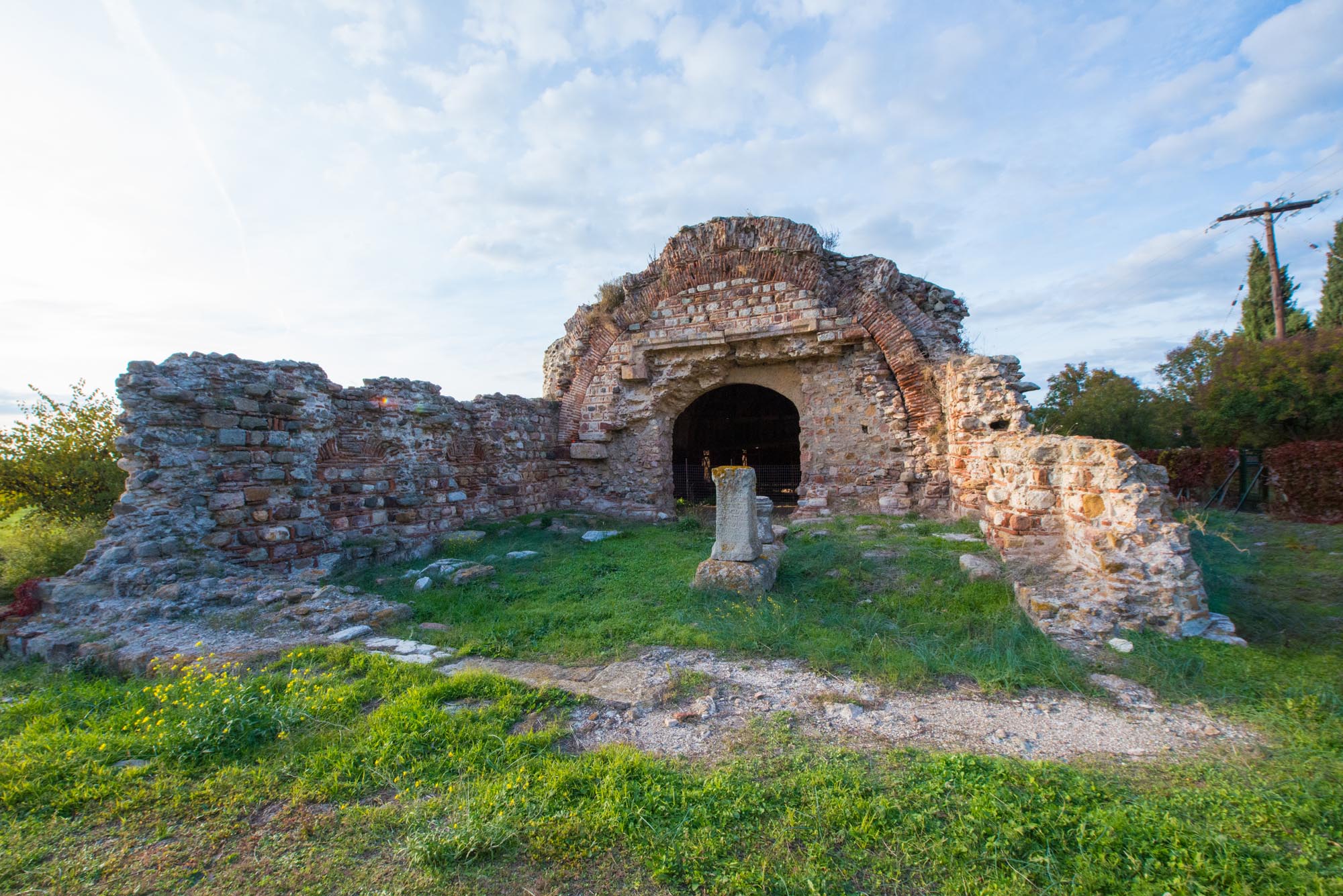
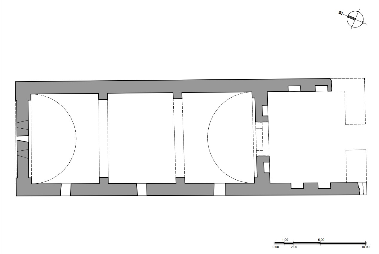