Topeiros

Topeiros, a fortified city on the banks of the River Nestos

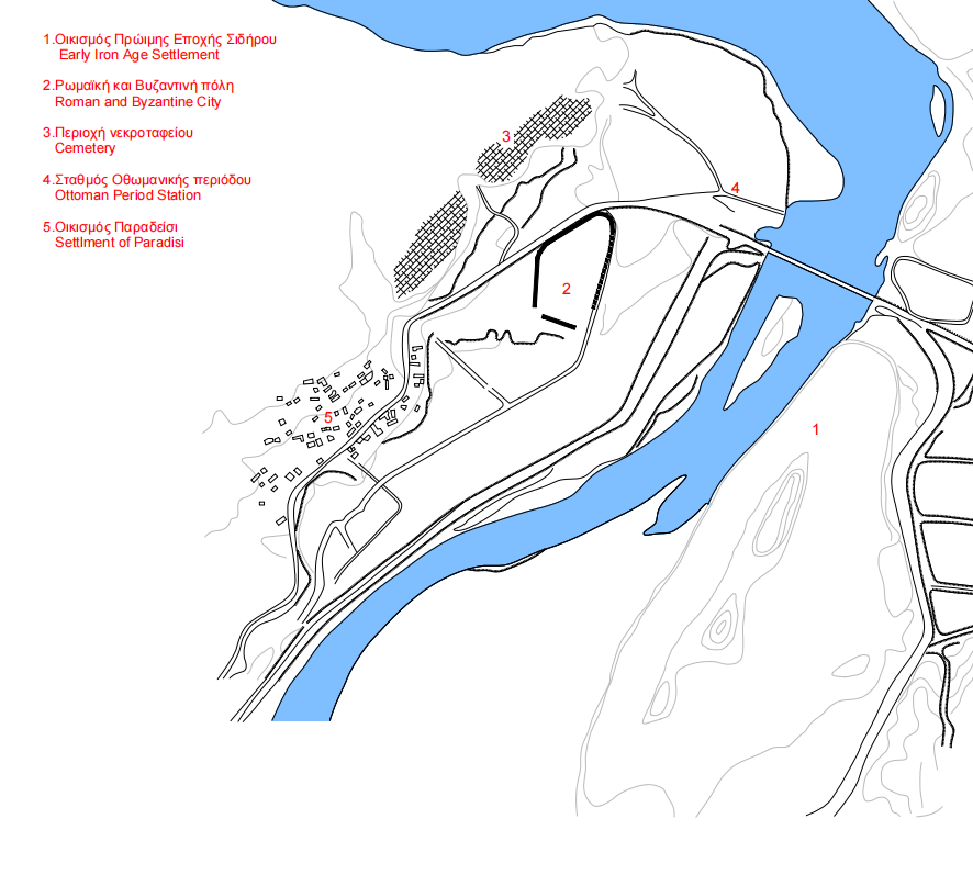
The ancient Thracian city of Topeiros is identified by most scholars with the remains of an ancient settlement on the hill of Kaledes or Petrota. The hill rises on the west bank of the River Nestos, near the village of Paradeisos, at the height of the present-day bridge of the Xanthi–Kavala motorway. According to the itineraria, Topeiros was an important station of the Via Egnatia before the crossing of the Nestos, and lay 17 or 18 Roman miles (25 or 27 km) from the last station of the Via Egnatia in Macedonia, the fortified town of Akontisma. During the construction of the modern bridge before the Second World War, successive gravel layers of an ancient road were found, which were thought to be part of the ancient Via Egnatia. However, it is also argued that that the Via Egnatia may have crossed the Nestos further south, at the height of the modern villages of Agios Athanasios and Kosmiti, like the old Ottoman Kavala–Komotini road. According to other researchers  Topeiros is also placed at different sites, for example near Kosmiti.

Topeiros was probably founded in the 1st century AD, when it is first mentioned by the Greek geographer Strabo. In the 2nd century AD it was listed among the “inland” cities of Thrace by the Greek geographer Ptolemy. In the environs of the village of Paradeisos is a group of earlier sites; according to Strabo, these were inhabited by the Thracian tribe of the Sapaeans. These sites seem to have gradually been abandoned due to the establishment of Topeiros, which was a powerful local centre. The importance of the city increased during the reign of Trajan (98-117 AD), when a broader programme to create major urban centres in Thrace was implemented, including the founding of Trajanopolis and Plotinopolis. Until the founding of Maximianopolis/Mosinopolis (285-305 AD), Topeiros was the only significant city in the region. Its territory extended across a large part of Thrace east of the Nestos, despite the difficulties caused by the fast-flowing river. The milestones of Topeiros which have been found both in the village of Aetolophos, in the east part of the plain of Komotini, and in Komotini itself, indicate that Topeiros controlled the Via Egnatia across much of Thrace, along the southern foothills of the Rhodope range up to the western border of the territory of Trajanopolis. Topeiros issued coins during the imperial period, from Antoninus Pius (138-161 AD) to Geta (209-212 AD). On the coins issued in 211/212 AD, the city appears under the title of Ulpia (OYLΠIAΣ TOΠEIPOY), linking its name to the Emperor Trajan, who was of Ulpian descent, in accordance with the customary Roman practice of inscribing imperial names (the nomen gentlicium or cognomen) on coins.

Τοπογραφικός χάρτης της περιοχής της Τοπείρου / Topographical map of the Topeiros area. X. Κουκούλη-Χρυσανθάκη, “Πορτρέτο της Αγριπίννας της Νεώτερης”, Θρακική Επετηρίδα 7, 1987-1990, σελ / p. 82, ψηφιακή επεξεργασία ΔΒΜΑ / digital processing DBMA

From the 5th century AD onwards, the city was an episcopal see, while it is mentioned in the Synecdemus of Hierocles (before 535 AD) as one of the seven cities of ancient Rhodope. The historian Procopius informs us that Topeiros was a populous city and that in 549-550 AD it was besieged by Slavs, who, concealed by the lush vegetation in front of its walls, surprised its defenders and captured it. After its destruction by the Slavs, in the last years of Justinian’s reign (527-565 AD) the city was reinforced with strong fortifications to control the crossing of the River Nestos more effectively. Its walls were raised so high that they exceeded the height of the hill next to the city. In ecclesiastical sources, Topeiros is mentioned as an episcopal see under the diocese of Trajanopolis up to the 9th century. The excavation data reveal that the city was finally abandoned around the mid-14th century.

Today a few remnants of the city’s fortifications are preserved on the hill of Kaledes or Petrota, covered by the lush riverside vegetation. The north section of the walls, parts of which are visible along the Kavala–Xanthi highway, survives in better condition. Various building phases can be identified in the city walls, generally matching the historical background of the city as it is known from the sources. The first building phase is dated to the 1st-2nd c. AD, while the second phase is that of Justinian’s repairs. A third phase is dated to the late 6th and early 7th century AD, while the final repairs to the city walls were carried out in the Late Byzantine period.

Μαρμάρινη επιτύμβια επιγραφή από την παλαιοχριστιανική βασιλική, αρχείο ΕΦΑ Καβάλας / Marble funerary inscription from the Early-christian basilica, archive of the Ephorate of Antiquities of Kavala

The cemetery of the Roman period extended across the slopes of the rocky hill to the north of the city, where rock-cut tombs and funerary inscriptions engraved on the rocks have been found. The most elaborate tombs have carved steps and are surrounded by a carved rainwater drainage channel.

Small-scale excavations have brought to light Early Christian architectural sculptures, as well as the east part of an Early Christian basilica  with a synthronon, around which seven graves were uncovered. The foundations of various buildings, mainly of the Roman and Early Christian periods, have also been revealed, including the remains of the city aqueduct. It is worth noting that the aqueduct did not carry water from the Nestos or the riverside springs, as one would expect, but from natural springs to the west of the city.

Other stops in the Regional Unit of Kavala

error: