Rentina

Rentina, the Byzantine castle-city that guarded the “Macedonian Tempi”

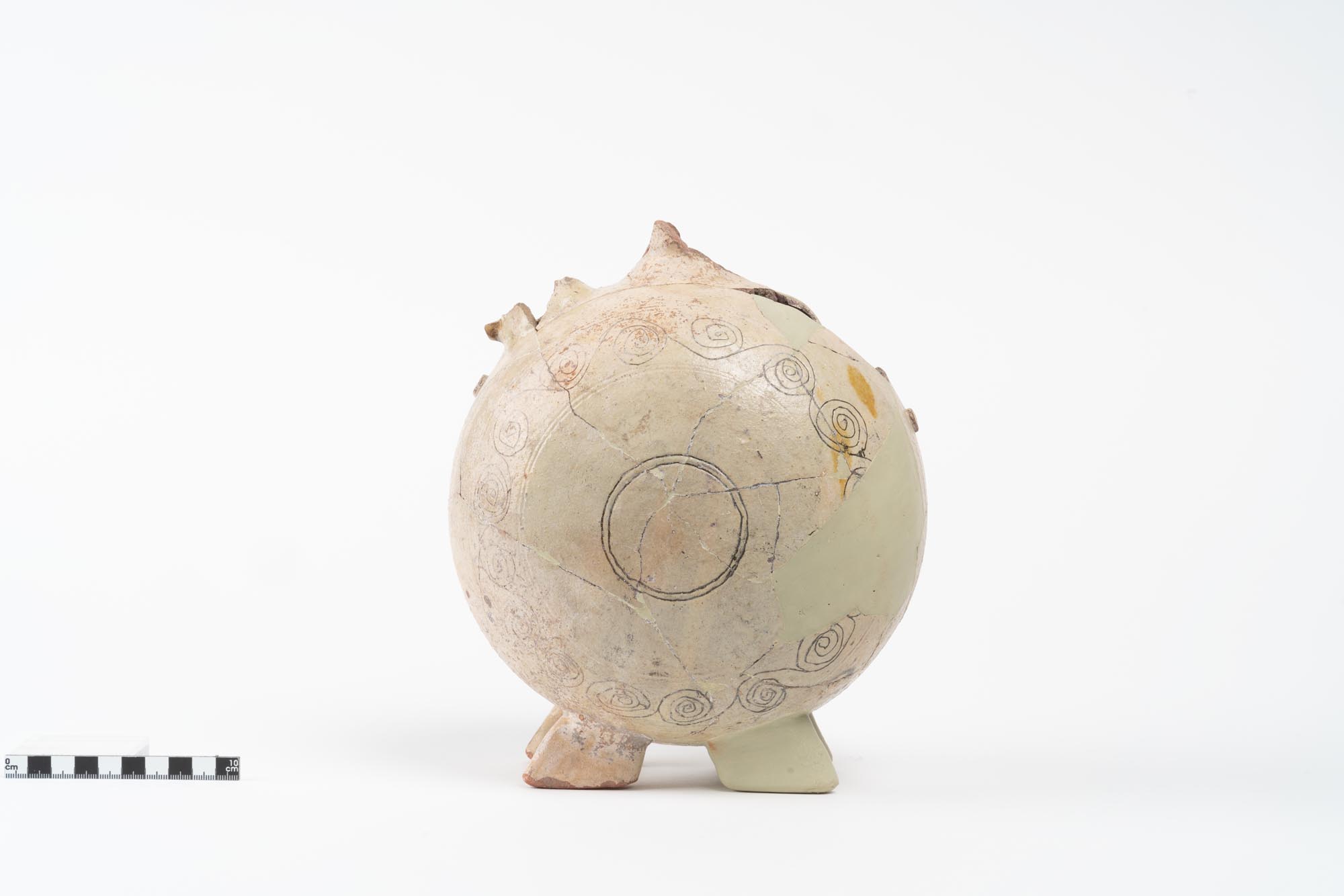
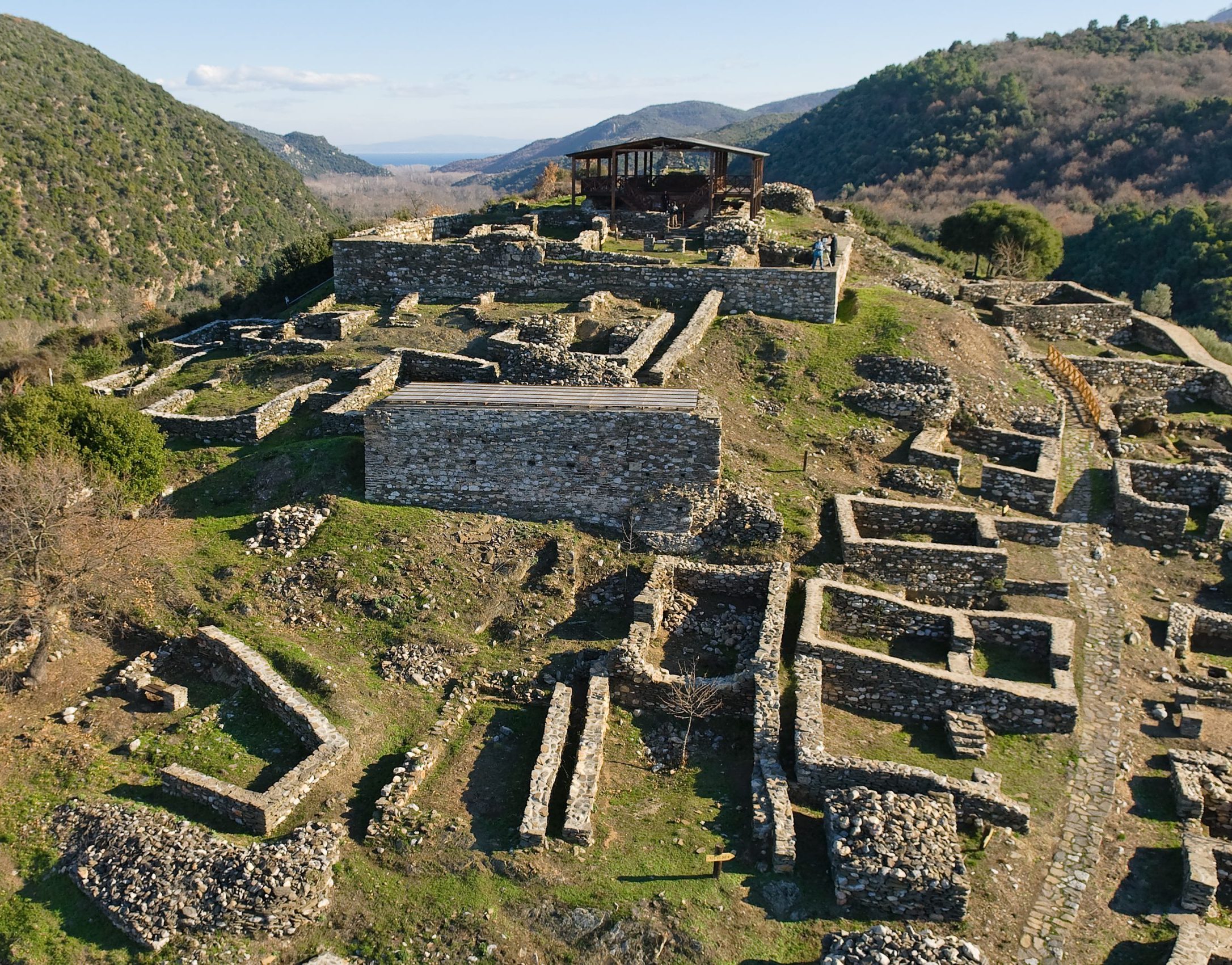
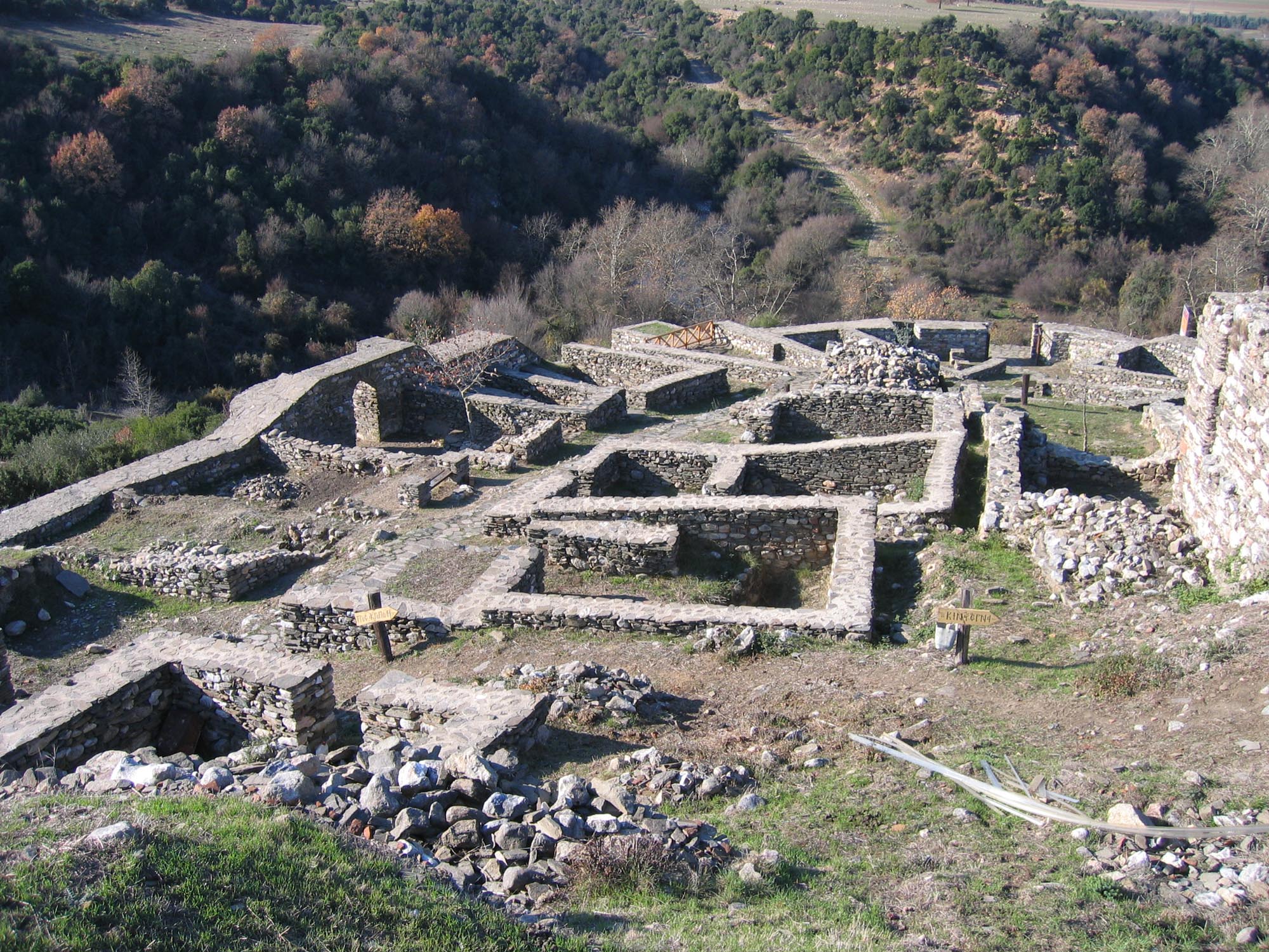
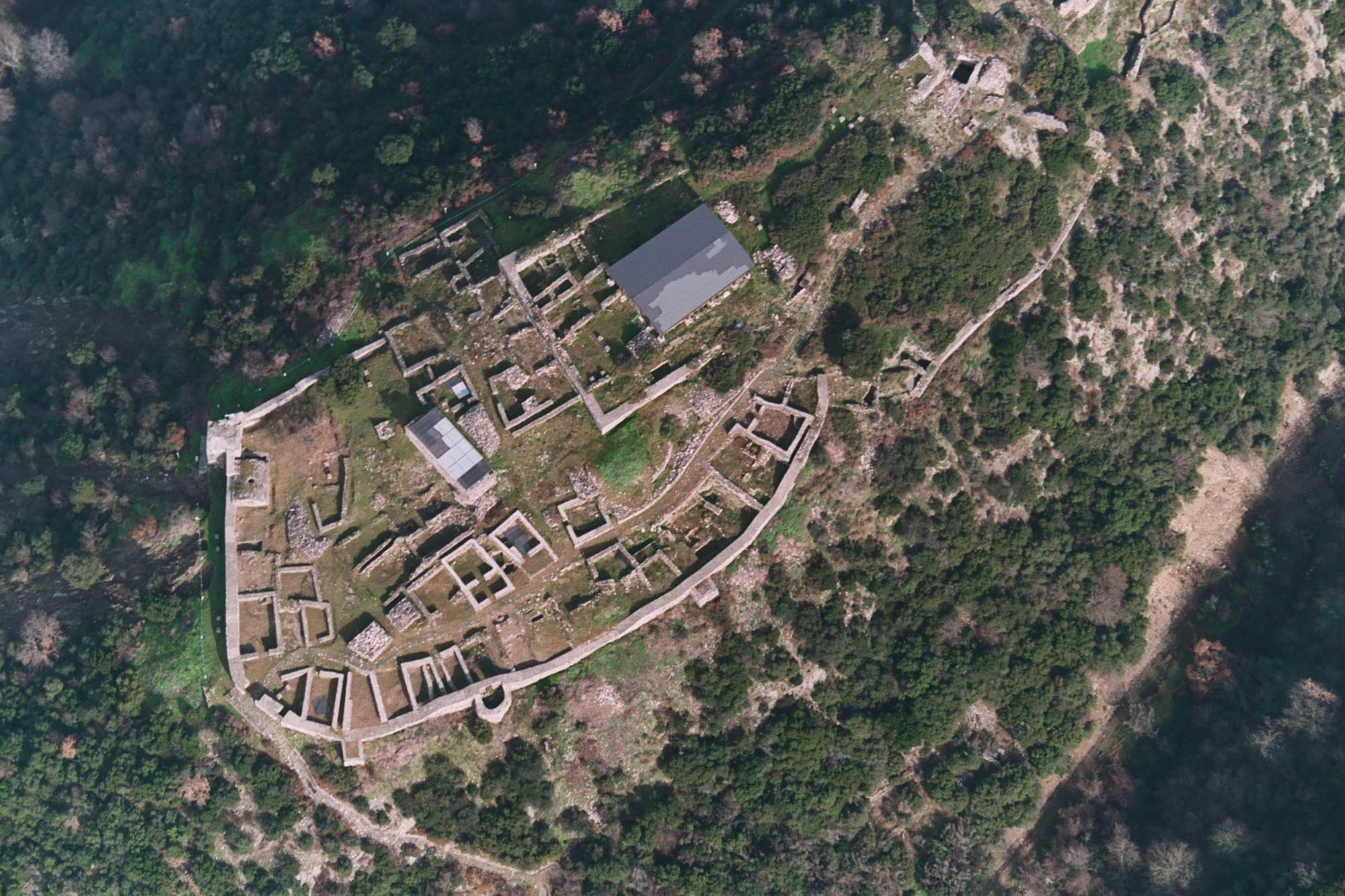
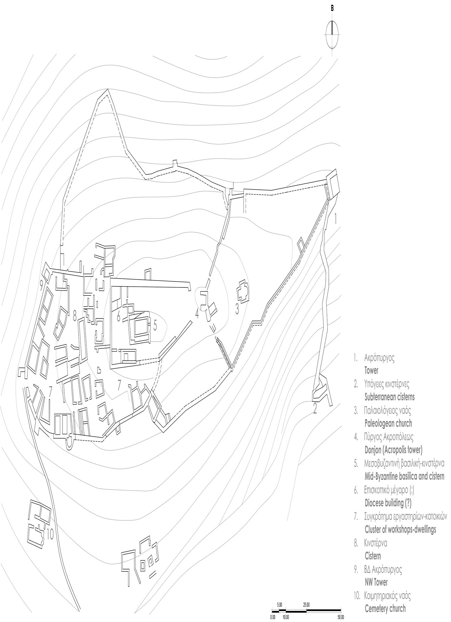
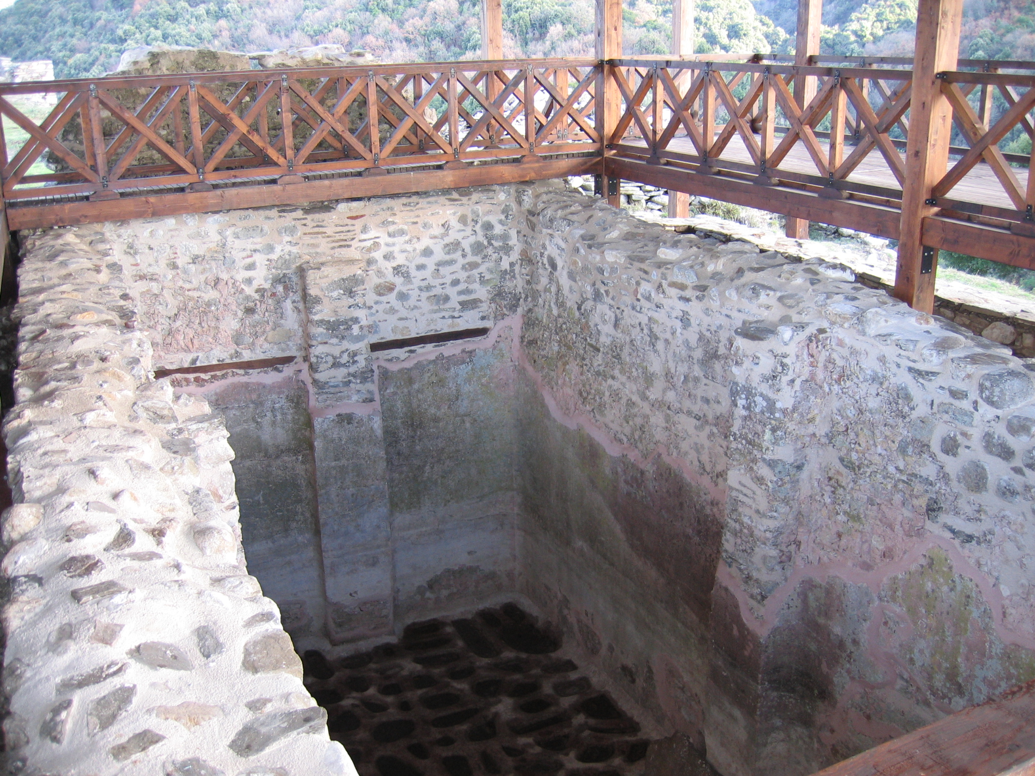
The archaeological site of Rentina is located about 70 km northeast of Thessaloniki, near Lake Volvi and the modern community of the same name. It is a fortified settlement of the Byzantine period, called Pyrgoudia (“small towers”) by the local inhabitants. It stands on the top of a low but inaccessible hill at the western end of the Rentina Gorge. Rentina was known as Aulona in antiquity, as Arenda, Eredine Bugaz or Rumili-Boğasi in Ottoman times, and as the “Macedonian Tempi” today. In ancient times, the Rentina Pass was part of the territory of Mygdonia, an area inhabited by Thracian tribes, and was probably annexed to the kingdom of Macedonia in the reign of Philip II (359-336 BC). The gorge is about 5 km long and lies between the mountains of Stefanina (Kerdyllion) and Stratonikos. The small River Rhechius flows down the valley, carrying the waters of Lake Volvi down to the Strymonic Gulf (Orfanos Gulf). The landscape of the gorge, with lush riparian woodland on either side of the riverbed, home to numerous bird species and a variety of reptiles and small mammals, is an area of outstanding natural beauty protected as part of the Natura 2000 network. The beauty of the landscape has not changed since the historian Procopius provided a vivid description of the area in the 6th century AD: “The river [the Rhechius] flows with a steady current, the water is calm and drinkable, the ground is level with many ploughed fields and marshes with good pasturage. In these respects the land is blessed …”

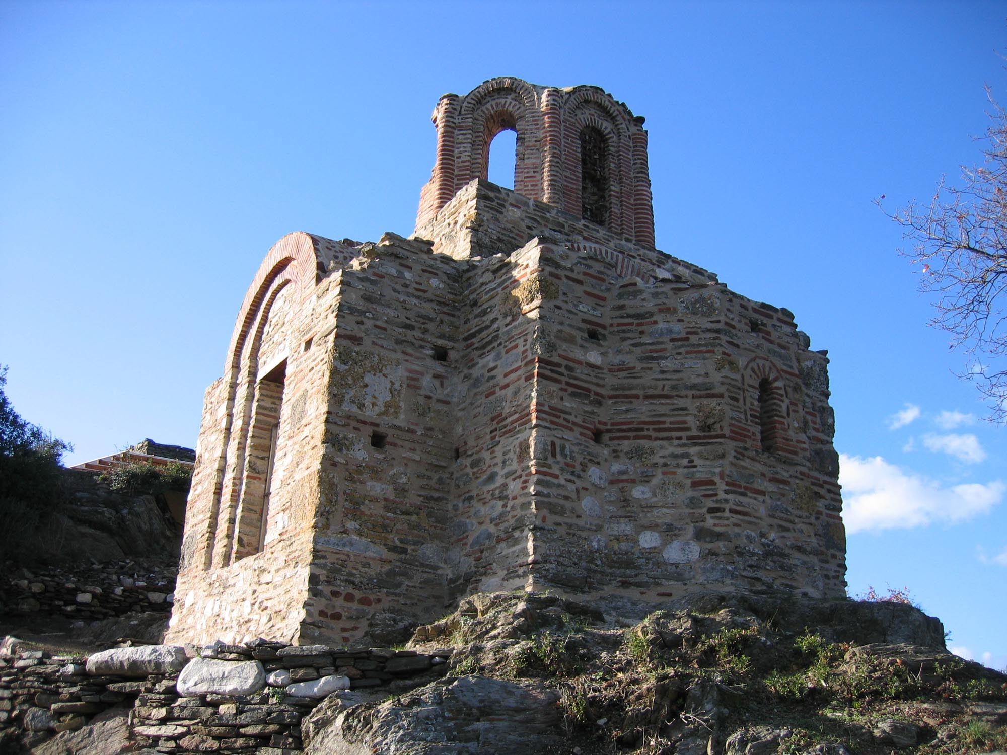
The Macedonian Tempi have been inhabited for thousands of years, since prehistoric times. During the Byzantine period, a well-designed defensive network consisting of a series of castles and individual towers was constructed in the area between Lake Volvi and the Strymonic Gulf. This was intended to protect the local population, while also serving as a line of defence for Thessaloniki. The fortified settlement of Rentina is part of this network.

Its location is of particular strategic importance, as it is close to the entrance of the Macedonian Tempi and controls the pass. It also oversaw the traffic on the Via Egnatia, which passed the northern foot of the hill on which Rentina stands. Indeed, as the Rentina Pass is the only passage from Macedonia to Thrace, an ancient road ran through here even before the construction of the Via Egnatia, following the same route. In modern times, the Thessaloniki–Kavala highway now passes through here.

After the station of Apollonia, the Via Egnatia ran through the Rentina Pass to the Strymonic Gulf before proceeding to Amphipolis. According to the Roman itineraria, 10 Roman miles after the station (mansio) of Apollonia was the changing station (mutatio) of Peripidis. This station has not been identified; however, according to the prevailing view, it was somewhere around the western entrance of the gorge, near the settlement of Rentina. Remains of an old road made of four-metre-wide conglomerate stones, which was in use until the beginning of the 20th century, can be seen at the site of Chania, just after the junction of the Thessaloniki–Kavala highway and the side road of Stavros, but this is near the eastern rather than the western entrance of the gorge. The remains of an installation of the Roman imperial period have been identified at the same site, its use probably continuing into Early Christian times.

The name of the Peripidis station has been claimed to be derived from its proximity to the tomb of Euripides, who, according to one view, is buried in Arethousa, an ancient city in the area. The tragic poet was invited to the royal court of Pella by the cultured King Archelaus (413-399 BC) and spent the last two years of his life there. According to one tradition, he met a tragic death in 407 or 406 BC, when he was devoured by hounds, punished because in his tragedy Bacchae, his last work, which he wrote in Macedonia, he revealed the Bacchic ceremonies performed by the women of the city of Arethousa. Archelaus arranged for Euripides to be buried with royal honours. The tragic poet is said to be buried in Arethousa, where an imposing monument was erected. The monument was preserved for many centuries and is mentioned by travellers who visited the area on their way along the Via Egnatia.

History

The Byzantine castle-city of Rentina is known today thanks to the systematic excavations carried out since 1976 by the Centre for Byzantine Research of the Aristotle University of Thessaloniki in collaboration with the competent Ephorate of Antiquities, under the scientific direction of Professor Nikolaos K. Moutsopoulos (1927-2019), who held this position for many years. The excavations have brought to light not only the remains of the Byzantine period but also finds indicating that the area has been occupied continuously since prehistoric times. However, the successive building interventions on the limited surface of the hill, combined with the small thickness of the fill, has resulted in the preservation of only a few architectural remains, belonging to the  Byzantine building phase of the settlement of Rentina.

The original fortifications of the settlement of Rentina date from the Late Roman period, in the mid-4th century AD. Then, during the Early Christian period, extensive building works were carried out to better organise the defence of the settlement. The walls of the earlier enclosure were reinforced and a large cistern was built in the centre of the settlement to provide drinking water. Moutsopoulos places these works in the reign of Justinian I (527-565 AD), based on the testimony of the historian Procopius that the emperor renovated the walls of the settlement of Artemision, which was located near the river Rhechius – the otherwise unknown settlement of Artemision is identified by the excavator as being that of Rentina.

Μαγειρικό σκεύος από τη Ρεντίνα, μεσοβυζαντινοί χρόνοι / Cooking pot from Rentina, Middle Byzantine period (Μουσείο Βυζαντινού Πολιτισμού, Museum of Byzantine Culture, Thessaloniki)
Εύρημα από τη Ρεντίνα, 12ος αι. / Excavation find from Rentina, 12th c. AD (Μουσείο Βυζαντινού Πολιτισμού, Museum of Byzantine Culture, Thessaloniki)

From the second decade of the 7th century AD, Slavic tribes known as Rynchinoi or Vlachorynchinoi settled in the area. The name Rentina first appears in the late 9th or early 10th century, when the episcopal see of Lete, another important city of Mygdonia, was transferred here under the newly unified title of the episcopal see of “Lete and Rentina”. The settlement of Rentina subsequently flourished and there is evidence of intensive building activity. Its fortifications were reinforced and strong towers were built at the most vulnerable points. Its location on the main public thoroughfare and its proximity to the sea and the rich resources of the region, such as timber, fishing and agriculture, made it a notable polichnion (small town) of the period, with several hundred inhabitants.

The history of Rentina is directly interwoven with events centred on Thessaloniki. In 1204, at the distribution of the territories of the Byzantine Empire by the forces of the Fourth Crusade, the region was included in the possessions of Boniface of Montferrat, the founder of the Latin Kingdom of Thessalonica. Then, from 1224 to 1242, Rentina became part of the territory of the Despotate of Epirus, the head of which, Theodore Komnenos Doukas, had extended his lands as far as Thessaloniki, where he was proclaimed emperor. In 1242, John III Vatatzes incorporated the region together with Thessaloniki into the Empire of Nicaea. According to the narrative of the historian George Akropolites, the soldiers of the castle’s defender John Komnenos Doukas, the successor of Theodore Komnenos, upon learning that John III Vatatzes was approaching and realising that they could not face the large Nicaean army, sought refuge in Thessaloniki, abandoning the castle, which passed into the hands of John III Vatatzes.

The town experienced a second period of prosperity during the Palaiologan period (13th-14th c.), when it became the seat of the kapetanikion (captaincy) of Rentina. During this period the walls were repaired and a church was built in the eastern part of the castle. In the 14th century, the katepanikion of Rentina absorbed the neighbouring katepanikion of Stefanina. During the Palaiologan period, the Athonite metochia (dependencies) in the area multiplied rapidly. The monasteries of Great Lavra and Esphigmenos, for example, each owned a mill in the Rentina area. The mother monasteries erected ramparted towers in the region to protect their dependencies.

Παλαιολόγειος ναός/ Palaiologan church (ρχείο ΕΦΑ Περ. Θεσσαλονίκης / archive of the Ephorate of Antiquities of Thessaloniki Region)
Αιχμές βελών από τη Ρεντίνα, 13ος-16ος αι., Μουσείο Βυζαντινού Πολιτισμού / Iron spearheads from Rentina, 13th–16th c., Museum of Byzantine Culture Thessaloniki

In 1342, during the Byzantine Civil War (1341-1347), the castle of Rentina was captured by John VI Kantakouzenos, who installed a magistrate (archon) and a garrison of 200 soldiers there before marching on Thessaloniki.

After the defeat of the Serbs at the Battle of Marica in 1371, the Ottomans began their advance into Thrace and Macedonia, which was completed in 1430 with the final fall of Thessaloniki. The area around Lake Volvi was conquered in the late 14th century, after the fall of Serres (1383). From this period onwards, the castle of Rentina fell into decline and was gradually deserted. Interestingly, while the archaeological evidence of the Ottoman period is limited, the tax registers show that Rentina remained an important Christian village during the first two centuries of Ottoman rule, being recorded in 1519 and 1527 as having over 100 households.

The archaeological finds date the final abandonment of the settlement to the mid-17th century. This may be connected to the founding of the new village of Stavros or, more probably, to the movement of Rentina’s population to the new semi-urban Ottoman centre of the region, Pazar-i Cedid (“New Market”, modern-day Apollonia), which began to develop after 1568.

During Ottoman times, the Rentina Pass was occasionally guarded by mercenaries (sekban) in order to ensure the safe passage of public revenues and travellers. The armed men were dispersed among small military posts (karakol) on either side of the pass. The costs of their salaries were borne by the local non-Muslim subjects. The French Consul-General at Thessaloniki, Esprit Marie Cousinéry, who visited the Rentina Pass in 1786, mentions the Rouméli Bogasi-Khan. This was probably a han at which a garrison was stationed, as it was usual at the time to place garrisons in hans with walls and watchtowers located on or next to the sites of earlier roadside stations. According to one view, the han-station in question was located on the site of the older Peripidis station of the Via Egnatia. In the early 20th century (1904), the cartographer and writer Michael Chrysochoos, the first person to systematically investigate the topography of the area, mentions a military post at the western entrance to the gorge, near the church of St Marina, and a wooden bridge over the River Rhechius. Despite the guards, the Rentina Pass was often pillaged by bandits. According to the French Jesuit François Braconnier (1656-1716), who visited the area in 1706, the locals called the Rentina Pass the “valley of brigands”.

The castle of Rentina is associated with one of the most decisive battles in Macedonia during the Greek Revolution of 1821. In early June 1821, the leader of the Greek Revolution in Macedonia, Emmanuel Papas (1772-1821), occupied the area between Rentina and Nea Apollonia. On 15 or 17 June, the small revolutionary force, led by Metropolitan Konstantios of Maroneia, faced the strong Turkish army of Bayram Pasha. The Greeks were defeated but managed to delay the Ottoman advance. The banner of the revolutionaries that was raised in the battle is now housed in the Monastery of Esphigmenos.

During the Second World War, the Germans fortified the Rentina Pass and mined the hill on which the settlement stands. The mines had to be removed with great effort when the excavation of the settlement began.

Άποψη του δυτικού τμήματος του κάστρου/ View of the western part of the castle (φωτ. ΕΦΑ Περιφέρειας Θεσσαλονίκης / Ephorate of Antiquities of Thessaloniki Region)

Monuments - Antiquities

Fortifications

The spindle-shaped castle is oriented east-west and encloses an area of approximately 15 hectares. The enceinte is reinforced by four-sided towers, attached to the strongest parts of the wall or self-standing at the most vulnerable parts. The south wall is protected by the only semicircular tower, an addition of the Justinian era. On the hilltop west of the castle stands the original 10th-century citadel, which has an irregular, quadrangular, elongated shape. Later, in the 14th century, the settlement acquired a new citadel, which occupies the northeast part of the hill and includes a keep, cisterns and a Palaiologan church of the 14th century.

A double transverse wall forming an obtuse angle divides the enclosed space into two unequal parts, the eastern one being smaller. The two arms of the wall start from the highest point of the fortifications of the original citadel, where a strong tower is built. The main gate of the castle is on the west side, with a secondary entrance on the southeast. From the main west gate, a 1.90-metre-wide road leads east to west up to the original citadel. Besides the main building phases of the mid-4th, 6th and 10th centuries, phases when the walls were reinforced in the 12th and 13th centuries have been identified. The walls of the first two phases were coated in white plaster.

Two churches are preserved today inside the walls (the episcopal church and the Palaiologan church). Outside the walls a single-nave, timber-roofed church has been discovered on the southwest slope of the hill, near the main gate in the wall. It was a funerary church, built in the late 9th or early 10th century.

The settlement was supplied with water by three more cisterns, apart from the one on the citadel on which the episcopal church was founded. Of particular interest is a large-scale engineering work to supply water to the settlement. At the foot of the hill, outside the southeast side of the castle, a complex of underground vaulted cisterns was built, which was supplied with water from the adjacent streams by means of a dam. The inhabitants of the settlement could access this complex via an underground vaulted staircase, about 56 m long, which started from the east keep of the castle.

Apart from the cemeteries close to the three churches of the settlement, another cemetery containing graves of the Roman period has also been discovered at the southwest foot of the hill, over the ruins of a monumental building. Burials of the Early Christian period were also found in the foundations of some of the houses in the settlement. The presence of burials within the fortified settlement departs from the usual practice of placing cemeteries outside the settlements for reasons of hygiene. It is also interesting to note a burial found within the mass of masonry of the east keep of the castle, an unusual case of a burial inside a building in the process of construction.


The remains of the three-aisled, timber-roofed basilica discovered in the centre of the original citadel constitute the episcopal church of the settlement. It dates from the 10th century and is founded on a large cistern of the Justinian age, which fell into disuse after the construction of the basilica. According to the excavator, Professor Nikolaos Moutsopoulos, the basilica had two storeys and its ground floor, where successive burials were discovered, was used as a burial space from the 10th to the 15th century. The area to the north and west of the basilica was also used as a cemetery. Northwest of the church is a complex of buildings believed to be the bishop’s palace of the settlement.

This free cross-plan church stands in the eastern part of the castle. Its north and south walls have been preserved to their full height, but much of the east and almost all of the west wall have been destroyed. The dome, of which a large part of the drum is preserved, is built entirely of brick, as is commonly the case with the Palaiologan churches of Thessaloniki. Inside the church, a few scraps of frescoes are preserved, but they have lost their colours and are quite weathered. The church was completely invisible until 1971, when it was revealed after the vegetation covering it was removed. A cluster of children’s graves has been excavated outside the southwest corner of the church.

αρχείο ΕΦΑ Περ. Θεσσαλονίκης / archive of the Ephorate of Antiquities of Thessaloniki Region

The houses are more densely clustered together in the western part of the settlement. In most cases they are built against the wall and adjoin the neighbouring house with a mid-wall. However, there are also detached houses. Most of the houses are rectangular, with a single ground-floor room. There are a few two-storey dwellings, in which the ground floor is a workshop and the upper floor is the residential space. One of the two-storey dwellings in the settlement had a covered balcony facing the street. The houses had a pitched or gabled roof, pitched towards the interior of the castle.

Other Monuments – Antiquities of the wider area

Arethοusa

The remains of the ancient Mygdonian city that flourished in the 5th-4th centuries BC, not to be confused with the modern village of Arethousa northeast of Lake Volvi, have been located southwest of the hill of Rentina, next to the River Rhechius. Excavations have brought to light parts of the city wall and cemetery.

At the Paliambela site, approximately 8 km from the ancient Via Egnatia, a three-aisled basilica with a narthex and a baptistery has been excavated. It was built before the mid-5th century and remained in use until the late 6th – early 7th century AD. A large part of the basilica was adorned with splendid mosaic floors. A wine press was discovered in the north aisle. In the same area seven large clay jars were found, which were used for storing wine, other liquids or food, along with amphora fragments and a hearth. The basilica probably served the needs of an Early Christian settlement, as the scattered architectural remains and tombs in its vicinity show.


αρχείο ΕΦΑ Περ. Θεσσαλονίκης / archive of the Ephorate of Antiquities of Thessaloniki Region

North of the village of Modi, next to the Thessaloniki–Kavala highway, just before the entrance to the western end of the Rentina Gorge, is one of the most famous monuments of the region. This is a domed transverse-vaulted church with a particularly elongated floor plan, reminiscent of a basilica on the outside. It has a slate roof. The church was built in the second half of the 18th century and renovated, according to an inscription, in 1869. It is connected with religious traditions related to the saint’s miraculous appearance to local residents. The festival of St Marina, on 17 July, is particularly popular, drawing throngs of people from the surrounding areas.

Other stops in the Regional Unit of Thessaloniki

error: