Xirovryssi, a monumental fountain in the plain of Serres
The impressive Οttoman fountain is located roughly 3 km west of the town of Rodolivos and 3 km north of the village of Mikro Souli, among the cultivated fields of the fertile plain of Serres. Today it is known as Xirovryssi or Xerovryssi (“dry fountain”), as it is no longer in use, but according to local residents it remained in operation until the Second World War.
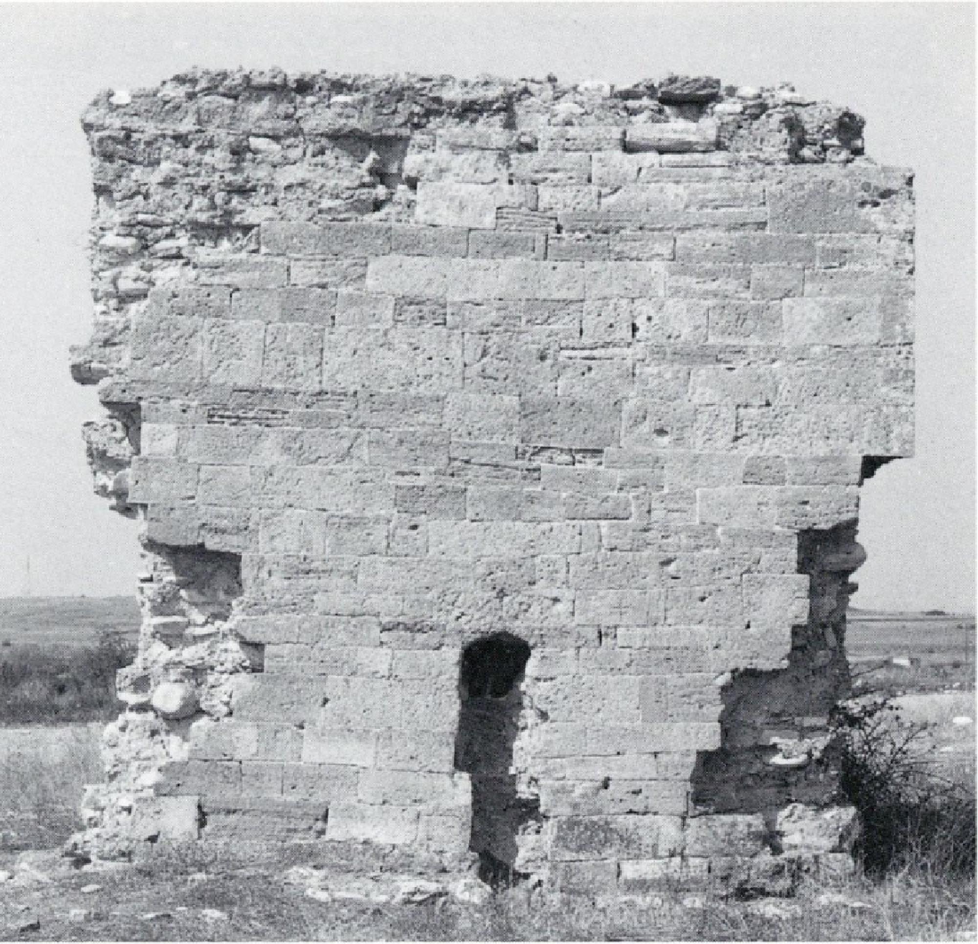
The fountain is oriented east-west, with the façade facing west. It is rectangular in plan with slightly curved sides, with a preserved length of 3.60 m and no more than 1 m wide. Although it has suffered considerable damage, it is preserved to its full height of 4 m. The fountain is faced with ashlars and its core consists of roughly dressed stones and pebbles cemented with lime mortar. The masonry is reinforced with horizontal and vertical timber frames.
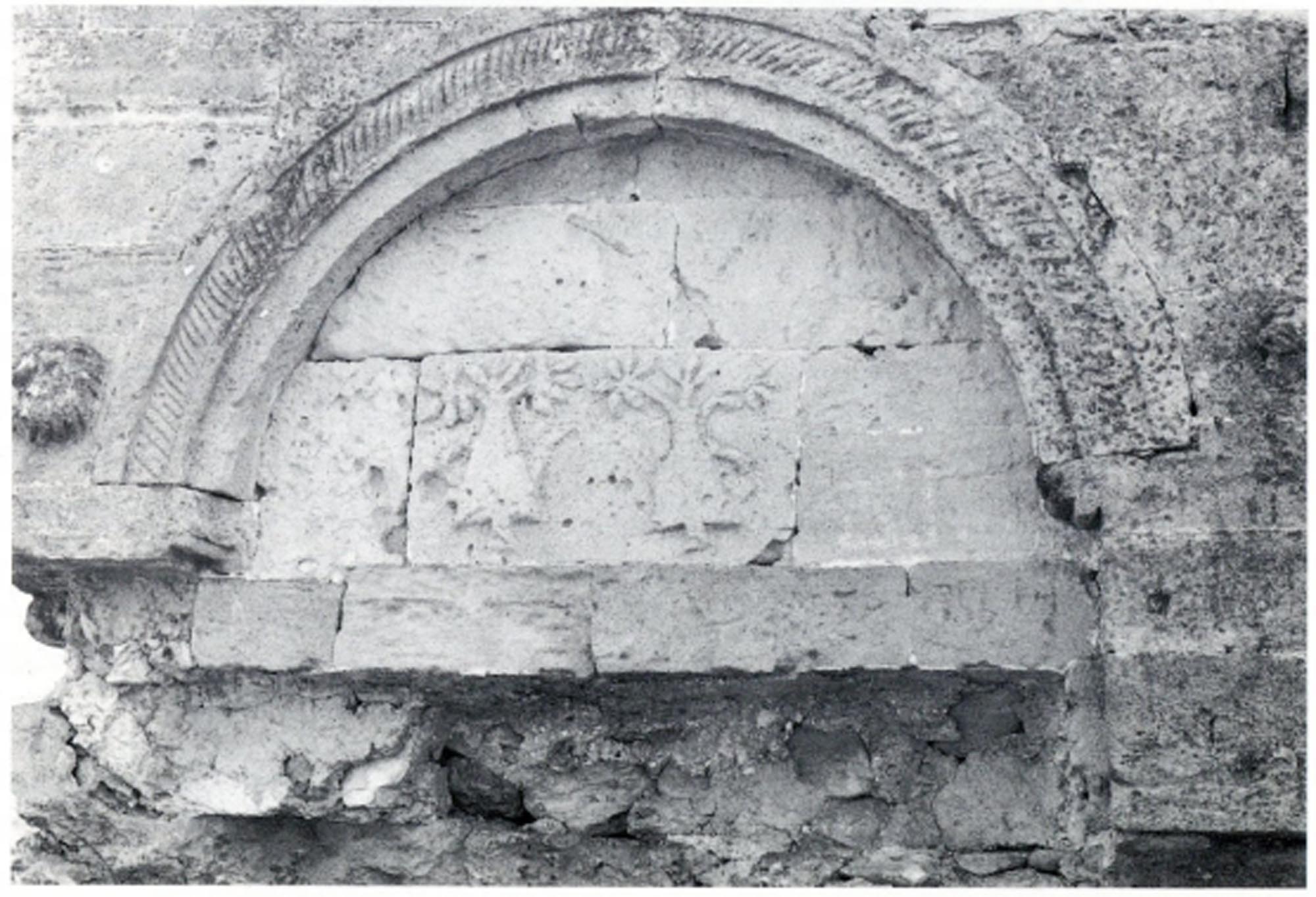
The façade is particularly elaborate. At a height of 1.90 m from the ground it is decorated with two shallow semicircular arches of grey limestone, 1 m in radius, of which only the north one is preserved intact. On the upper part of the façade, from the springers of the arches upwards, the fountain is faced with rectangular grey limestone blocks in courses of equal height. The drums of the two arches of the façade are similarly faced with yellowish ashlars, giving the fountain a two-tone hue. The lower part of the façade, under the two arches, was probably also faced with yellowish limestone, but this has been removed.
The two arches are inscribed in a rectangular frame, delimited at the top by a wavy border and on the sides by a wavy border and a relief rope. The semicircular opening of the two arches is framed by three stepped bands, the middle one also decorated with a relief rope. Over the top of each arch was a relief rosette, only one of which survives today. Two six-petalled rosettes in a circle are carved into one of the ashlars on the left of the first, north arch. At the bases of each arch were three carved relief features, of which only two survive. The researchers who have studied the monument, Moschos Otatzis and Petros Samsaris, believe that these are lion’s heads.
The decoration of the façade was completed, at the time of the publication of the monument by the two researchers (1996 and 2004), by two stone blocks placed in the centre of the drum of each arch, each adorned with two relief flower vases. Today, however, the two stone blocks have been removed from the fountain. There is also a rectangular gap in the cladding between the two arches, probably left by an inscription that has also been removed.
The other sides of the fountain would have been unadorned, but they had a facing of greyish limestone similar to that of the façade. The facing is preserved almost intact on the rear east side of the fountain. The facing on the south side does not survive, while on the north side it is preserved from the springers of the arches upwards.
The water reached the fountain through a terracotta pipe terminating in the centre of the back of the fountain. From there, two terracotta pipes, one vertical and one horizontal, built into the thickness of the fountain’s walls, channelled the water into two stone or perhaps metal spouts, 1.50 m apart and 1.20 m above the ground.
Based on its morphological features and decoration, the fountain dates from the Ottoman period (second half of the 17th – first half of the 18th c.). Its presence in a purely rural area, far from any settlement, indicates that it was located on a road of the time. Otatzis mentions the remains of a road nearby, 1.5 km north of the village of Mikro Souli. The road, probably of the Ottoman era, is 150 m long and 6.00-6.20 m wide, and has been extensively damaged by the construction of modern rural roads and ploughing. The roadbed is made of loose stones laid on a very thin layer of compacted earth, which is laid in turn on the bedrock. The central section is slightly elevated, with a row of vertical slabs running along both sides of the road. The local inhabitants mention similar sections of roadway running in the same direction, northeast, to the north of the town of Rodolivos, as well as even further north, close to the town of Proti, leading to the hypothesis that this road ran from Amphipolis to Kavala, following the course of the modern Amphipolis–Kavala provincial highway.
The Via Egnatia followed a similar course during Roman and Byzantine times, along the northern foothills of Mount Pangaion rather than the southern ones, as was the case in Ottoman times. Some researchers place its course very close to Mount Pangaion, while others place it quite far away, passing through the modern villages of Domeiros and Angista. The first view is supported by the discovery near Mikro Souli, a village on the northern slopes of Mount Pangaion, of a milestone of the Via Egnatia with three inscriptions stating that it was made in Amphipolis and placed 9 Roman miles east of it, a distance that does indeed correspond to that between Mikro Souli and Amphipolis (14 km) (see Amphipolis). Researchers also suggest that Domeros, a changing station (mutatio) of the Via Egnatia 13 Roman miles from Amphipolis according to the Itinerarium Burdigalense, should be sought in the area of Xirovryssi, a few miles north of Mikro Souli.