Florina

Florina, a town on the banks of the River Sakouleva

Florina, now the capital of the eponymous Regional Unit of Western Macedonia, is a town with a long history and a rich intellectual and cultural tradition. It has been described as the coldest city in Greece: its chilly climate is due to its elevation and its geographical position between large mountains. The town is crossed by the River Sakoulevas, the “river”, as the locals call it. Its picturesque banks, known as the “beach”, with their bridges, cobbled streets and wealthy mansions, lend Florina a special charm, making it one of the most popular destinations in Western Macedonia.

Florina has been inhabited since prehistoric times. In antiquity it lay within the geographical boundaries of Lyncestis or Lyncus, a region of Upper Macedonia with a robust economy and a high standard of living and culture. According to the historian Thucydides, Lyncestis was inhabited by “nations” who were “allies” and “subjects” of the Macedonians, until King Philip II incorporated them into the Macedonian state. In antiquity, the city of Florina spread across the eastern foothills of the now densely wooded hill of Agios Panteleimon, outside the southern limits of the modern town, where excavations have brought extensive building remains to light. The identification of the ancient city of Florina with any of the known ancient cities of Lyncestis remains problematic due to lack of data. It is widely accepted by researchers that in Byzantine times the ancient city was succeeded by the fortified town of Chlerinos (Chlerenos). Little, however, is known about the extent and location of the Byzantine settlement. Later, during the Ottoman period, the town was called Florina by the Greek-speaking population, Hlerin and Lerin by Slavic speakers, and Filurina, Filorina, Filerina and Florina by Turkish speakers. It developed on the site of the modern town, on either bank of the River Sakoulevas.

During Ottoman times, an important road artery, which via Monastir (present-day Bitola) connected Macedonia with the Balkans, passed through Florina. The passage of the Ottoman road played a crucial role in the emergence of Florina as an important economic and commercial centre of the region.

A milestone of the 4th century AD, now lost, which was discovered in the late 19th century near the church of St Athanasios in the village of Sitaria (formerly Resna) west of Florina, provides important information on the course of the Via Egnatia through the plain of Florina during Roman times. The milestone bore three inscriptions, one Greek and two Latin. The Greek inscription stated that Dyrrachium lay 168 Roman miles from the ancient city that had commissioned the milestone, the name of which has not survived, but which was probably Heraclea Lyncestis, the largest urban centre in the area (present-day Bitola). Based on the milestone, after the narrow pass of Kili Derven, the Via Egnatia seems to have followed a northwards course, passing through the Sitaria area. There is insufficient evidence of its route from there to Heraclea Lyncestis. Most researchers, however, consider it probable that the Via Egnatia did not branch off to the west, passing through the ancient city of Florina, like the road that succeeded it during Ottoman times. Instead, it took a shorter route, running north through the middle of the plain of Florina, roughly matching the course of the modern highway leading to the village of Niki, on the North Macedonian border. In fact, near the village of Kato Kalliniki, a little south of Niki, is the Via Egnatia changing station (mutatio) of Melitonus, mentioned in the Itinerarium Burdigalense as being 13 Roman miles (about 19 km) from Heraclea Lyncestis.

In any case, the Via Egnatia is believed to have been one of the factors that contributed to the great commercial and economic prosperity of the ancient city of Florina, even if it did not pass directly through it but a few kilometres further east, across the plain. The location of the ancient city is a particularly strategic one, overlooking almost the whole Florina plain, which extends to the east, between the mountains of Varnous (Peristeri) and Voras (Kaymakchalan). The ancient city of Florina also controlled the road that led from the Prespa region to the plain of Florina through the Pisoderi Pass.

History

The first traces of habitation in the ancient city of Florina, on the hill of Agios Panteleimon, date from the 2nd millennium BC. Based on the pottery finds, life in the settlement continued during the Early Iron Age (c. 1100-675 BC) and the Classical period (5th-mid 4th c. BC). However, as in the case of the Hellenistic city of Petres, the systematic habitation and urban plan of the ancient city of Florina dates from the reign of Philip II (359-336 BC). The city flourished and continued to do so after the Roman conquest of Macedonia in 168 BC and the inclusion of Lyncestis, along with the other regions of Upper Macedonia, in the Fourth Meris (regio), one of the four administrative regions into which Macedonia was divided by the Romans. The city remained prosperous even after the abolition of the merides and the establishment in 148 BC of the Roman Provincia Macedoniae, when the regions of Western Macedonia were granted special privileges by the Romans due to their favourable attitude towards the conquerors.

The range of Florina’s commercial transactions and cultural contacts during the Hellenistic and Roman periods with other major centers of the time is attested by the stamped amphora handles from various parts of Greece (Thasos, Rhodes and Kos) and the Italian peninsula, taken together with the numerous coins found in the excavations. Many of the clay vases from the excavations come from Pella, testifying to the close contacts between the ancient city of Florina and the capital of the Macedonian Kingdom.

Λόφος Αγ. Παντελεήμονα με την ελληνιστική-ρωμαϊκή πόλη/ Hill of St Panteleimon and the Hellenistic-Roman city (ΔΒΜΑ, φωτ. Κ. Ξενικάκης/ DBMA, phot. K. Xenikakis)
Από την ελληνιστική πόλη Φλώρινας (αρχείο ΕΦΑ Φλώρινας) From the Hellenistic city of Florina (archive Ephorate of Antiquities of Florina)

Habitation in the ancient city of Florina was interrupted at the beginning of the 1st century BC when the city was destroyed by fire, a few years before the destruction of the ancient city of Petres (mid-1st c. BC). The burning of the city is attributed to enemy forces, who, taking advantage of the Roman conflicts, invaded from the north and plundered the Macedonian lands. The ancient city of Florina seems to have subsequently been abandoned and only reinhabited in Byzantine times, a period attested by two graves and a few movable excavation finds.

Little is known about the Byzantine settlement of Chlerinos, which, according to the prevailing view, succeeded the ancient city of Florina. Professor of Classics Nikolaos Papadakis and archaeologist Antonios Keramopoullos earlier identified the ruins of fortifications on the hill of Agios Panteleimon, which were attributed to the reign of Justinian (527-565 AD). A surface survey carried out in 2012-2017 around the Koula and Gyftopoula peaks of the hill by architect-engineer Aineias Oikonomou and archaeologist Panagiotis Georgopoulos brought to light parts of fortified enclosures and various other architectural remains. In combination with the surface pottery, the two researchers place these in the Early Christian and Byzantine periods, during the reigns of Justinian and Basil II Boulgaroktonos (the Bulgar-Slayer) (976-1025) respectively.

Chlerinos first appears in written sources just before the middle of the 14th century; it is mentioned by Emperor John VI Kantakouzenos (1341–1354) as one of the four castles in the wider region, over which the Byzantine official Sphrantzes Palaiologos had been put in charge in 1334. By the mid-14th century, the area of Western Macedonia had come under the control of the powerful Serbian ruler Stefan Dušan. In 1334/5, the Serbian ruler granted extensive lands in the Chlerinos region to Treskavec Monastery near Prilep in North Macedonia. The donation charters to the monastery (1343/4 and 1344/5), attest to the existence of a market at Chlerinos, which included a church dedicated to Saint Nicholas. On the basis of the above, we must suppose that, during the Byzantine period, Chlerinos was a castle-city on the hill of Agios Panteleimon. It is not clear whether an early settlement nucleus including the market had already developed on the site occupied by the town in Ottoman times, as no excavation has been carried out and no Byzantine monument has been identified in the modern town of Florina to date.

Around 1385, the region of Florina was conquered by the Ottomans; some scholars believe that Chlerinos was captured by Gazi Evrenos. We do not know when the new name of Florina was established. It appears in 15th-century Ottoman tax registers and on 16th-century maps. The question of when the fortified castle-city of Chlerinos on the hill of Agios Panteleimon was abandoned and when the Ottoman town arose on the site of the modern town of Florina also remains open. It was probably after 1481, as an Ottoman tax register of that year refers to the Ottoman commander of the fortress, which presupposes the existence of fortifications. Afterwards, as was the case with many Ottoman cities, Florina never acquired new walls and remained unfortified.

title | αρχείο ΔΒΜΑ, φωτ. Κ. Ξενικάκης / archive of DBMA, phot. K. Xenikakis

Ιn the first half of the 16th century, Florina was designated the seat of a sancak or livas (a larger administrative division) despite its small population, estimated at around 1,600 inhabitants. From the end of the 16th century, however, it was the seat of a kaza belonging to the Sancak of Monastir. In the second half of the 16th century it was a Sultan’s hâss, with privileges which it retained into the following century. From the 16th century onwards, the demographic picture of the town began to change as the Muslim population grew, significantly outnumbering the Christian population in the 17th century.

The picture of Florina in the 17th century is provided by the Ottoman traveller Evliya Çelebi, who visited the town in in the late 1670s. It was not particularly prosperous at the time and had all the characteristics of a small provincial Ottoman town. It consisted of six districts with 500 tile-roofed, stone-built houses, set at a distance from each other, with “paradisal” vineyards. Of the religious and public buildings of the town, Evliya Çelebi, perhaps with some exaggeration, mentions 17 mosques (mosques and mescits, small district mosques), three madrasas (religious schools), one tekke (dervish monastery), two hammams, two hans and a hundred shops.

From the middle of the 17th century, Albanian bandits were active in Florina, attacking passing caravans and local villages. Banditry became more prevalent in the 18th century, destabilising the economic life of the region and leading to demographic upheavals. The climate of anarchy and insecurity in the wider Florina area lasted until the end of the 18th century, when, on the initiative of the Ottoman beys of Monastir, military detachments were organised to pursue the bandits, and the town’s population gradually increased. In 1881 there were 11,000 inhabitants, of whom 6,500 were Muslims and 4,500 were Christians. It is mentioned that at the end of the 19th century Florina had seven mosques, two tekkes, a madrasa, a secondary school (rüşdiye), a primary school (ibtidâiye), five Muslim, two Greek and one Bulgarian schools, two churches, 300 shops, 19 hans and a hammam.

Παλιά πόλη/ old city (αρχείο ΔΒΜΑ / archive of DBMA)

From the second half of the 19th century onwards, Florina found itself at the centre of the national conflicts that broke out in the Balkans after the creation of the new nation states and the impending collapse of the Ottoman Empire. The national rivalries culminated in violent armed conflicts during the Macedonian Struggle (1904-1908). A few years later, during the First Balkan War (October 1912 – May 1913), Florina was incorporated into the Greek State after the victorious advance of the Greek Army (7 November 1912). Greece’s diplomatic and military conflicts with Bulgaria and Serbia continued during the First World War (1914-1918). In 1916, Florina became the headquarters of the Entente and the French Army (Armée d’Orient). Major engineering works were carried out to meet the needs of the Allied troops, such as road building, sewage works and the construction of a railway line and a funicular. Postcards and photographs of the period provide important information on the topography of the town. Throughout this time, extensive military operations and refugee movements affected the demographics of the town, whose makeup was to shift again with the exchange of populations after the Asia Minor Catastrophe (1922).

Until the mid-1920s, Florina displayed the typical characteristics of an Ottoman town, with five Muslim and six Christian districts. It had seven mosques, scattered in an imaginary broken line from the eastern to the western end of the town, at relatively regular intervals of 250-500 m. Following the incorporation of Florina into the Greek State (1912) and the establishment of Greek authorities in the town, an attempt to reshape its urban fabric was launched, with the preparation of a new urban plan which was entrusted to the French engineer Alfred Leguillon in 1913. The urban plan of Florina, the “French Map”, was completed in 1918. It was approved by Royal Decree in 1919 and began to be implemented after the population exchange in 1924. Buildings were demolished and others erected in their place, gradually changing the face of the town. Demolitions continued in the following decades, with the result that today, of the Ottoman monuments of the town, only the base of the minaret of the Market Mosque, a hammam and a kule (tower) remain.

Monuments - Antiquities

The Hellenistic-Roman city of Florina on the hill of Agios Panteleimon

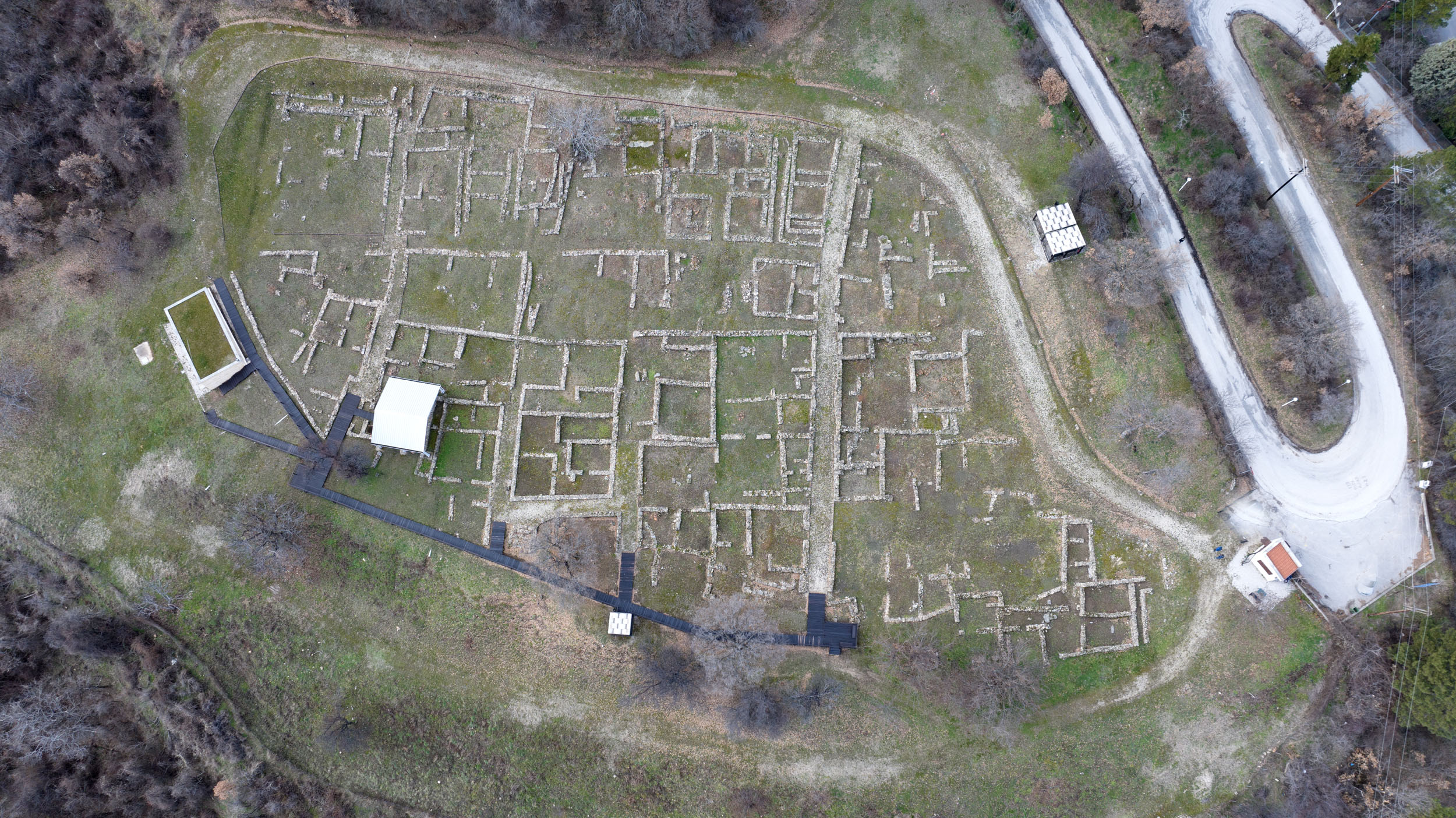
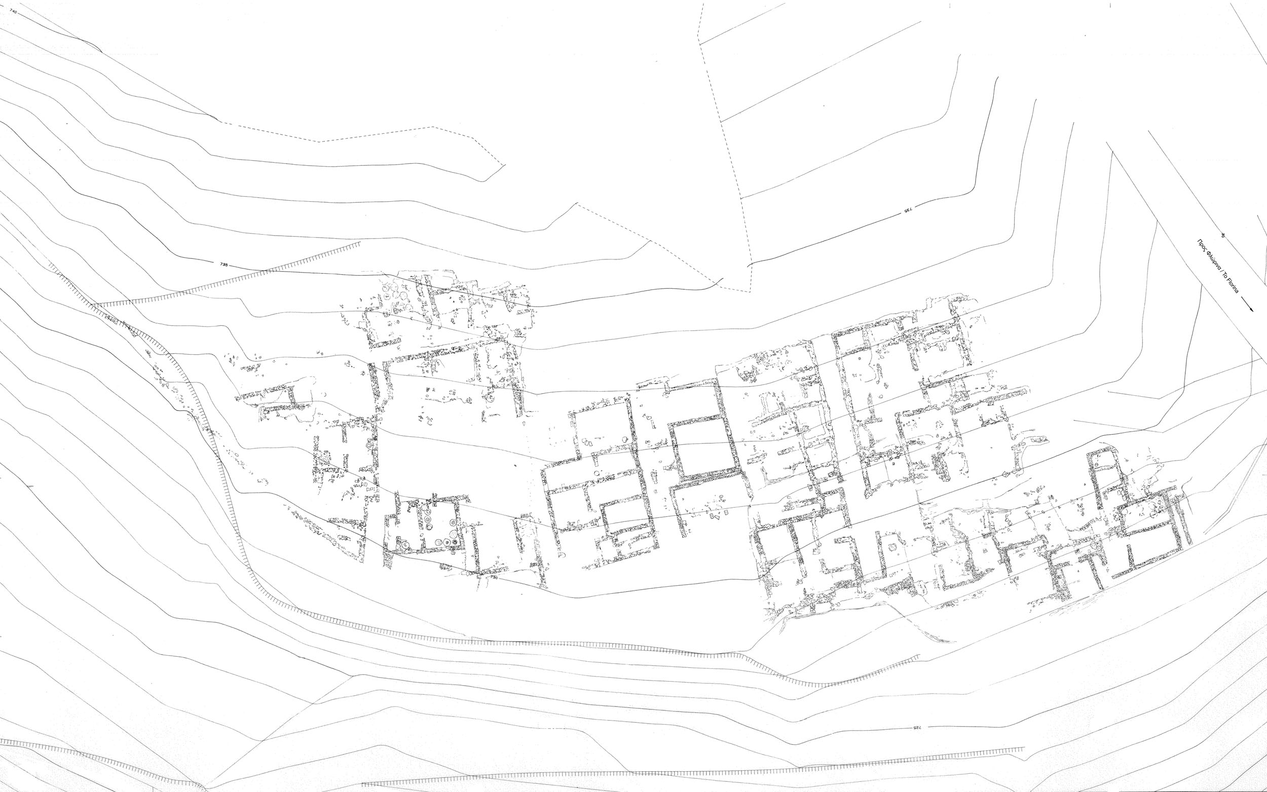
The excavated archaeological site, which has been landscaped and is open to the public, covers an area of about 8,000 m2. The original area of the city would have been much larger, however, as, based on the surface finds, it seems to have extended higher up the densely wooded hill. Part of the ancient city was also discovered a little lower down, on the north hillside, in an excavation carried out in 1930-1934 by the archaeologists Antonios Keramopoullos and Georgios Bakalakis. However, the architectural remains of this first systematic excavation were destroyed in the late 1950s when the Xenia Hotel was constructed on the site.

The influence of the town planning system of the great cities of Macedonia, with Pella, the capital of the Macedonian Kingdom, being the most representative example, is evident in the urban plan of the city. The city is made up of large rectangular building blocks divided by streets 3 m wide running east-west and north-south, and smaller streets 1.00-1.50 m wide running north-south. Smaller streets, 0.60 m wide, separate the properties and facilitate rainwater drainage. Under the main streets run built drains which are usually covered with stone slabs, or in some cases with tiles. Smaller drains carried water from the courtyards and inside the houses to the main drains. The town had an additional water supply system, as the discovery of clay water pipes indicates.

Each of the building insulae contains four to five houses with three to five spaces. One of the spaces, usually the largest, faces east and is open-air, sometimes with porticos with wooden supports on one or more sides. These open spaces have elaborate floors paved with stone slabs, tile sherds or gravel. Oval or circular hearths, 1.20-1.50 m in diameter, were found in some of the rooms of the houses. Almost all the houses had storerooms with large storage jars set in the floor or, more rarely, in low enclosures covering one side of the room. Many jars contained the remains of burnt cereals. Some masses of burnt grains bear the imprint of canes of woven baskets used for their storage.

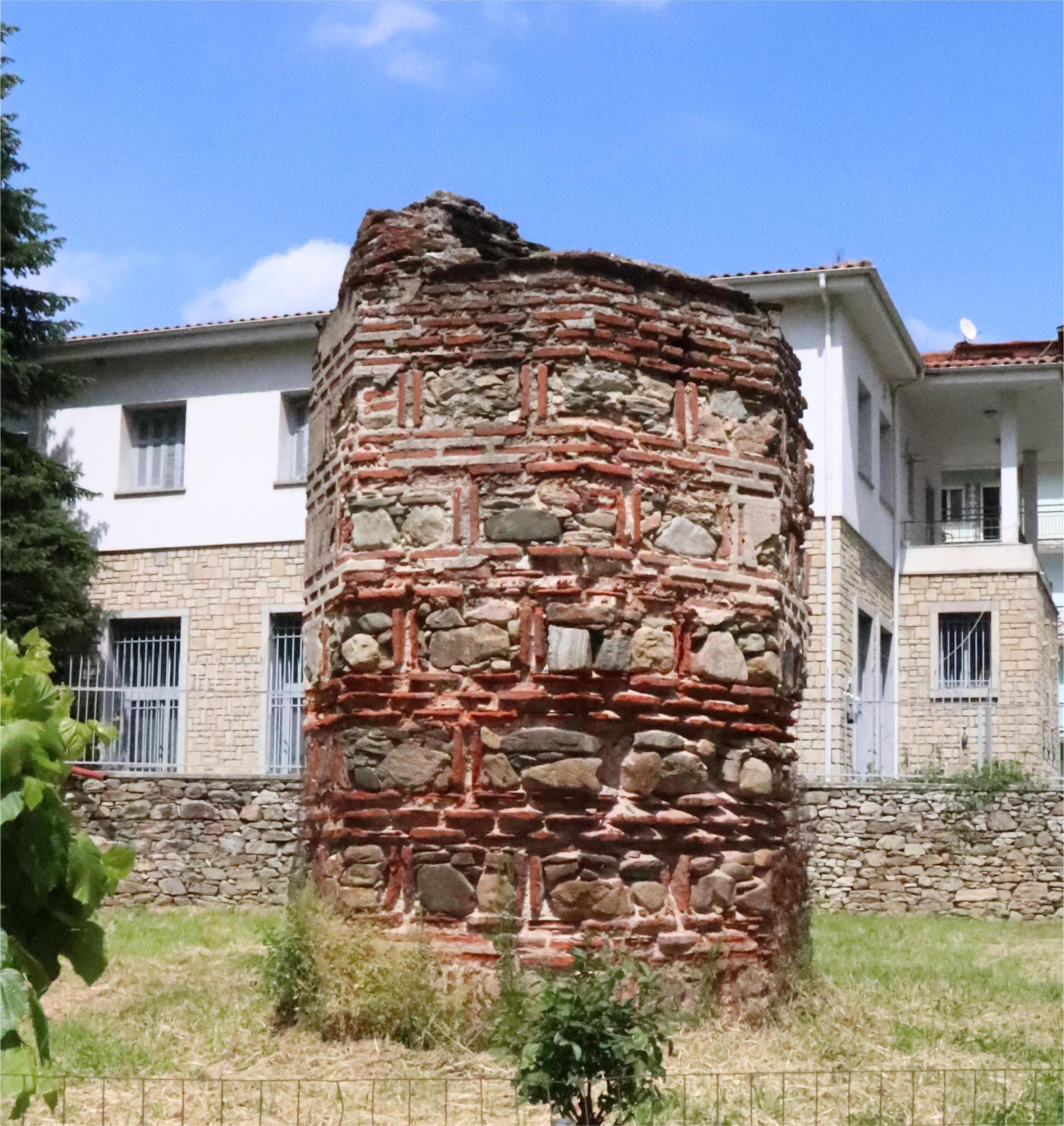
The walls of the houses, 0.45-0.50 m wide, are built of rough-hewn stones, without mortar, to a height of about a metre. The upper courses would have been of brick, as would some of the internal walls. Where the terrain necessitated it, the walls were wider (0.60-0.80 m) and raised to match the terracing of the built-up area. Some walls were also reinforced with buttresses. They were often coated with white plaster, while multicoloured plasters were also found in places. The floors were usually earthen, but in several cases they were paved with pieces of tile or small stone chips. There were also cleaning shafts in the floors, consisting of clay jars covered with stone slabs. The houses were roofed with large Laconian-style tiles. Some of the tiles, which would have been placed in the centre of the roof, had a large hole for ventilation and additional lighting.

The city depended not only on farming but also on industry. In some of the houses were discovered parts of smelting kilns, iron slag, iron ore residues and polished stones for sharpening metal tools, indicating that metallurgical workshops operated there. A local pottery workshop also operated in the town, as we see from pieces of moulds and seals found in the excavations.

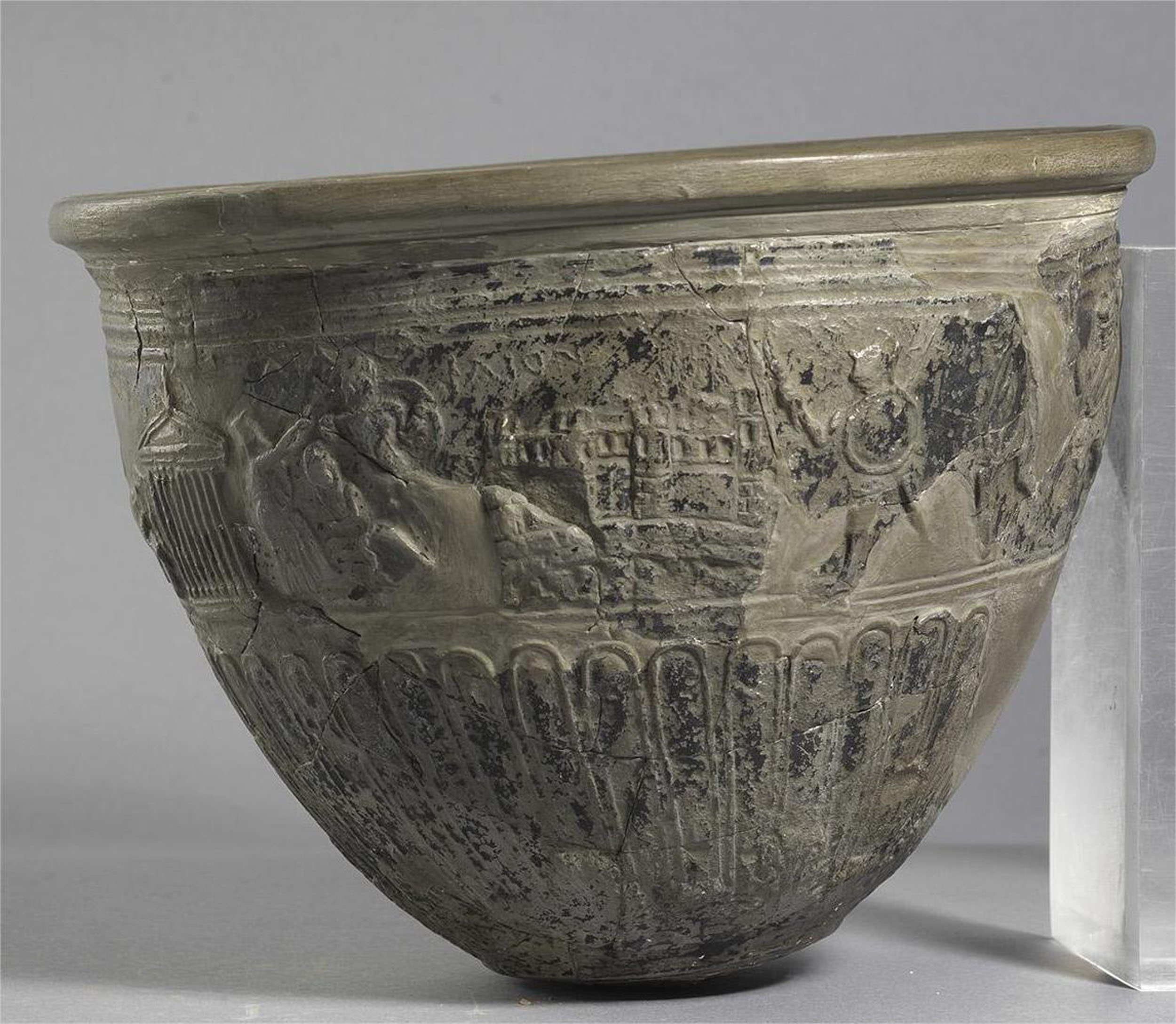
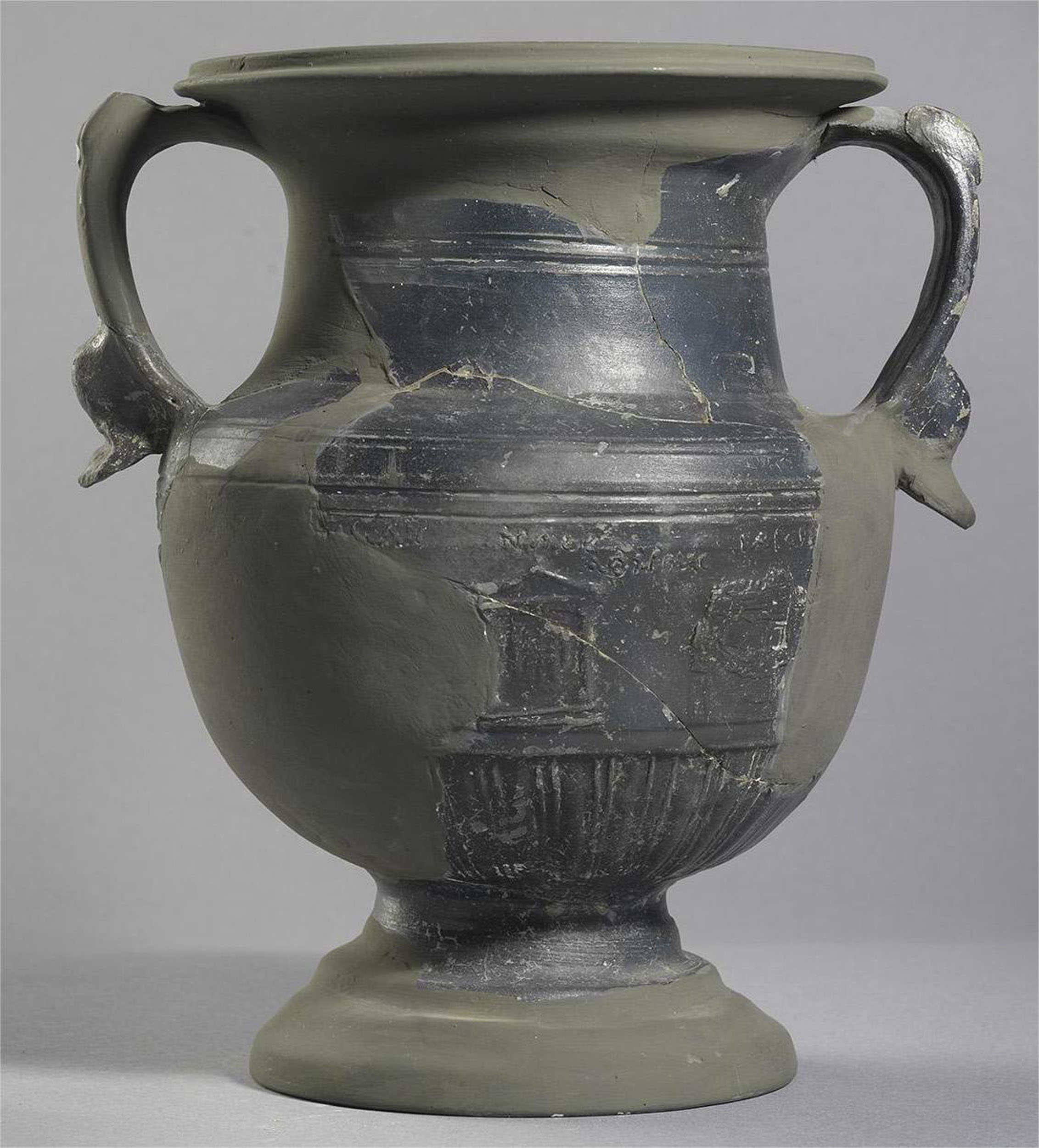
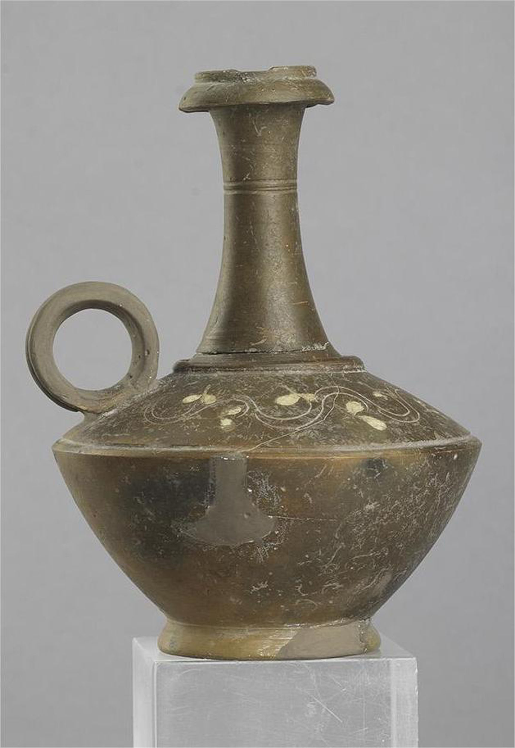
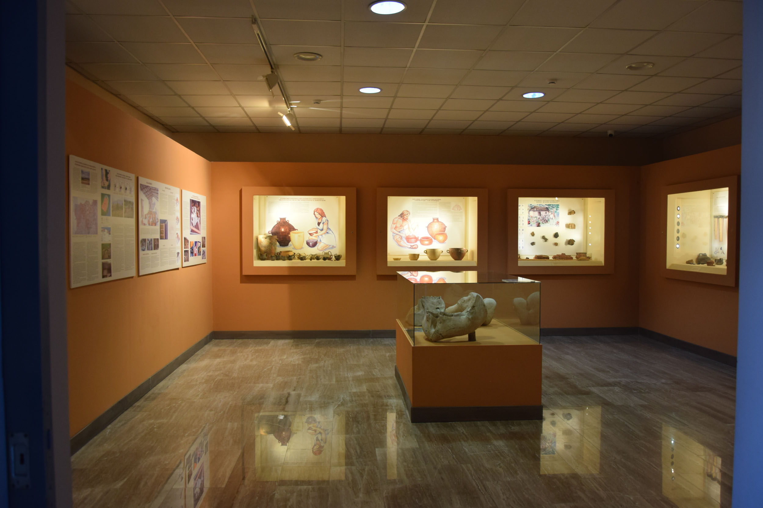
The excavation yielded a large number of movable finds, mainly clay vases (relief skyphoi). As at the ancient city of Petres, some examples stand out: they bear relief decoration, floral or with narrative representations, mainly depicting themes of the Trojan cycle, as well as war and erotic scenes. Numerous coins and glass vessels were also found and, more rarely, faience vases, bronze utensils and iron objects, mainly tools but also keys, door fittings, cooking tripods (gridirons), etc. The numerous agricultural tools and the sizeable quantities of stored grain attest to the farming activities of the inhabitants. Many loomweights have also been found, indicating the existence of a developed weaving industry in the settlement. No sanctuary has been uncovered to date, but ritual and symbolic objects found in the excavations testify to the worship of deities of the Greek pantheon.

The city cemetery was located at the east foot of the hill, northwest of the modern cemetery. Rock-cut chamber tombs of the late Hellenistic period were discovered there in 1934. There is no information on the fortifications of the settlement. On the highest terrace of the hill two trapezoidal ashlars have been found, most probably from a fortified enclosure.

Of the Market Mosque (Çarşı Camii), also known as the Old Mosque (Cami-i Âtik), which was demolished in 1953-1954, only the base of the minaret is preserved today. The minaret, which was attached to the northwest corner of the mosque, was originally about 20 m high and was the tallest in the town. Its base is preserved today to a height of 3.40 m and has an irregular hexagonal plan. It is built in cloisonné masonry, with three rows of bricks in the horizontal and two in the vertical joints.

The Market Mosque was located in the Market District, which was the largest in the town, with 525 properties. The Market District also contained most of the town’s shops and other important Muslim buildings, such as the tall, square Clock Tower, which was demolished in 1927.

The Mosque was part of a larger building complex which included a dervish tekke of the Halvetî order, a guest house belonging to the tekke, a dervish cemetery, a madrasa and an Ottoman primary school (mekteb). According to the most prevalent view, this is the mosque built in 1473 by Yakub Bey, a grandson of Gazi Evrenos, who, in order to maintain the mosque, created a vakıf of which the endowment deed (vakfiye) survives. It states that, in addition to the mosque, Yakub Bey also founded a poorhouse (imâret).

The minaret has been dated to the second half of the 18th century and is believed to stand on the site of an older minaret.

The hammam is located near the bed of the River Sakoulevas, on the west side of Dikaiosynis Square. The small hammam, which was built in the late 16th or early 17th century and remained in operation until 1958, consists of a rectangular central nucleus which includes the hot room and the water tank. The hot room is covered by a hemispherical dome with small lighting holes. An individual bath and an antechamber with a vaulted ceiling were added to the northeast part of the hammam in the second half of the 18th century. Later, at the beginning of the 20th century, another room was added to the southeast part.

Of the original two-storey tower house, only the ground floor is preserved today in a dilapidated state, near the bed of the Sakoulevas, in the historic heart of the town. This is a square building with an entrance in the middle of the south wall. The ground floor is 4.75 m high and is covered by a hemispherical dome supported on the side walls by four squinches at the corners. Both the hemispherical dome and the squinches are made of brick. Eight pointed relieving arches, also of brick, are formed within the squinches of all four walls. The tower house dates from the late 18th or early 19th century.

There was another similar, though slightly larger, two-storey tower house on Thrakis Street, in the Albanian quarter, which was demolished in 1930. The tower houses of Florina are a type of defensive residence linked to the presence of powerful Muslim families in the town – according to oral tradition, the kule on Fouledaki Street belonged to a bey. 

Numerous traditional houses are preserved in Florina, dating from the 19th century and sharing many features with the houses of the large urban centres of the Balkans, such as the neighbouring Monastir and Kruševo in North Macedonia, Berat in Albania, and Kastoria. Their main typological elements are the oda, the private enclosed living and eating space, the hayat, the semi-outdoor covered balcony, and the sofa, the communal enclosed space, the equivalent of the parlour. Many of Florina’s traditional houses are located in the picturesque Varosi district, one of the town’s Christian quarters, which developed along both banks of the River Sakoulevas and, as it was not redeveloped in modern times, has been largely preserved intact.

At the beginning of the 20th century, on the initiative of Hasan Tahsin Uzer, the kaymakam (provincial governor) of Florina, major engineering works were carried out (widening of the Sakoulevas riverbed, construction of a pier, bridges, etc.) and some of the most important public buildings in Florina were erected. These include the Government House (now the Courthouse), the two-storey residence of the Turkish governor of the town (now housing the Training Centre and the Centre for the Prevention of Drug Abuse), the Florina National Boarding School for Boys (now the Social Welfare Centre of the Region of Western Macedonia) and the old prison (now the Florina Magistrates’ Court).

Many more listed and Neoclassical buildings in Florina bear witness to the town’s important cultural heritage and rich architecture.

Museums

Archaeological Museum (8 Sidirodromikou Stathmou St.)

The Museum tells the story of habitation in the wider area of Florina from Neolithic times to the Byzantine period. One unit of the exhibition is dedicated to the finds from the excavations of the ancient cities at Petres in Amyntaio and on Agios Panteleimon hill in Florina.

The Museum also houses the Byzantine Collection, which includes remarkable exhibits from the Prespa region dating from the 10th to the 18th century.

The Museum’s rich collection consists of over 700 works by Greek and foreign artists from the beginning of the 20th century to the present day.

The Florina Art Gallery is housed in the old railway station building and its collection comprises works by local artists.

The museum houses a rich collection of local costumes, household utensils and other objects associated with weaving and the traditional occupations of the region.

The numerous exhibits of the Museum and the accompanying photographs highlight the multicultural character of local folk culture. The Museum also has one of the richest collections in Greece related to beekeeping and candle-making, a craft that flourished in the Florina region.

Other stops in the Regional Unit of Florina

error: