Egnatia
The Via Egnatia through the ages
Α. THE COURSE OF THE VIA EGNATIA
Introduction
The Via Egnatia, one of the greatest military and commercial roads of antiquity, connecting the Adriatic with the Hellespont, was the main road artery built by the Romans in the Balkan Peninsula and a remarkable feat of engineering for its time. It was an extension of the Via Appia, the Appian Way, which connected Rome with Brundisium (modern Brindisi). The Via Egnatia ran through Epirus, Macedonia and Thrace. Its main course has been preserved over the centuries and even forms the basis of the modern road network. It was constructed, following the traces of older roads, between 146 and 120 BC by the Roman Proconsul of Macedonia, Gnaeus Egnatius Gaius, after whom it is named. Major repairs to sections of the Via Egnatia were carried out in the 2nd and 3rd centuries AD by the emperors Trajan (98-117 AD), Hadrian (117-138 AD), Marcus Aurelius (161-180 AD), Septimius Severus (193-211 AD) and Caracalla (198-217 AD), while in the early 4th century, during the Tetrarchy, the road was also repaired by Galerius (305-311 AD).
The original purpose of the road was to facilitate the unhindered movement of the Roman legions who, after the Battle of Pydna in 146 BC and the conversion of Macedonia into a Roman province, expanded their possessions eastwards. Macedonia and Thrace, with their fertile plains, forests, rivers, lakes and rich deposits of gold, silver and iron, were important regions for the Romans, and the Via Egnatia played a crucial role in their conquest. The road is also associated with other key events in Roman history: the opposing armies moved along the Via Egnatia during the civil war between Julius Caesar and Pompey (49-45 BC), while the war between Octavian Augustus and Mark Antony on the one hand, and Julius Caesar’s assassins Cassius and Brutus on the other, was fought there until their final confrontation at the Battle of Philippi (42 BC). In addition to military purposes, the road served the rapid movement of state couriers (cursus publicus) and the movement of travellers and merchants, and facilitated the settlement of Roman citizens in the fertile plains of the eastern provinces of the Empire. It was thus instrumental in maintaining the economic and cultural interactions of the regions it linked, both with each other and with Rome itself.
Written sources
There are many written references to the Via Egnatia, which had a total length of approximately 1,120 km when it was completed, extending as far as Constantinople. A valuable source of information is the description of the geographer Strabo (c. 63 BC-24 AD). Based on a now-lost passage of Polybius, he states that the road as it was originally laid out from Dyrrachium to Cypsela on the Hebrus (Evros) was “measured by pillars every mile” along its entire length. The occasional references to the road by the politician and orator Cicero (106 BC-43 BC), as well as by Byzantine writers, are also useful. Equally important are the Roman itineraries (itineraria), descriptive travel guides to the Roman Empire, which record the towns (civitates), stations (mansiones) and changing stations (mutationes) where travellers could rest and change horses along the route. The Antonine Itinerary of Diocletian’s reign (284-305 AD) contains geographical names and distances. For the benefit of pilgrims, the slightly later Itinerarium Hierosolymitanum or Burdigalense (333 AD) of Constantine’s time describes the route from Burdigala, now Bordeaux in France, to Rome and thence to the Holy Land via the Via Egnatia.
The 12th-century Tabula Peutingeriana in Vienna is also a valuable source of information. It is a copy of an ancient map of the Roman Empire, on a parchment scroll 6.80 m long and just 34 cm wide, that depicts the known world from Britain to India, including the Via Egnatia. Information on the cities along the route is also provided by an anonymous Latin work, the Ravenna Cosmography, which contains 5,000 place-names of the known world in the 7th century.
Finally, a wealth of information on the course and operation of the road during the Ottoman period is found in the descriptions of 16th- and 17th-century travellers. Those by the Venetian diplomat Lorenzo Bernardo (1534-1592), the French naturalist Pierre Belon (1517-1564) and the Ottoman traveller Evliya Çelebi (1611-1682) are the most striking. Similar references can be found in later travel works, such as those of the French consuls in Thessaloniki in the first half of the 19th century Esprit Marie Cousinéry and Louis-Felix de Beaujour, the philhellene François Pouqueville (1770-1838), the British soldier and diplomat William Martin Leake (1777-1860) and the painter and poet Edward Lear (1812-1888). Finally, in 1886, Major Nikolaos Th. Schinas provides information on the Via Egnatia in his study Travel Notes on Macedonia, Epirus and Along the New Frontier Line and Thessaly.
Archaeological remains
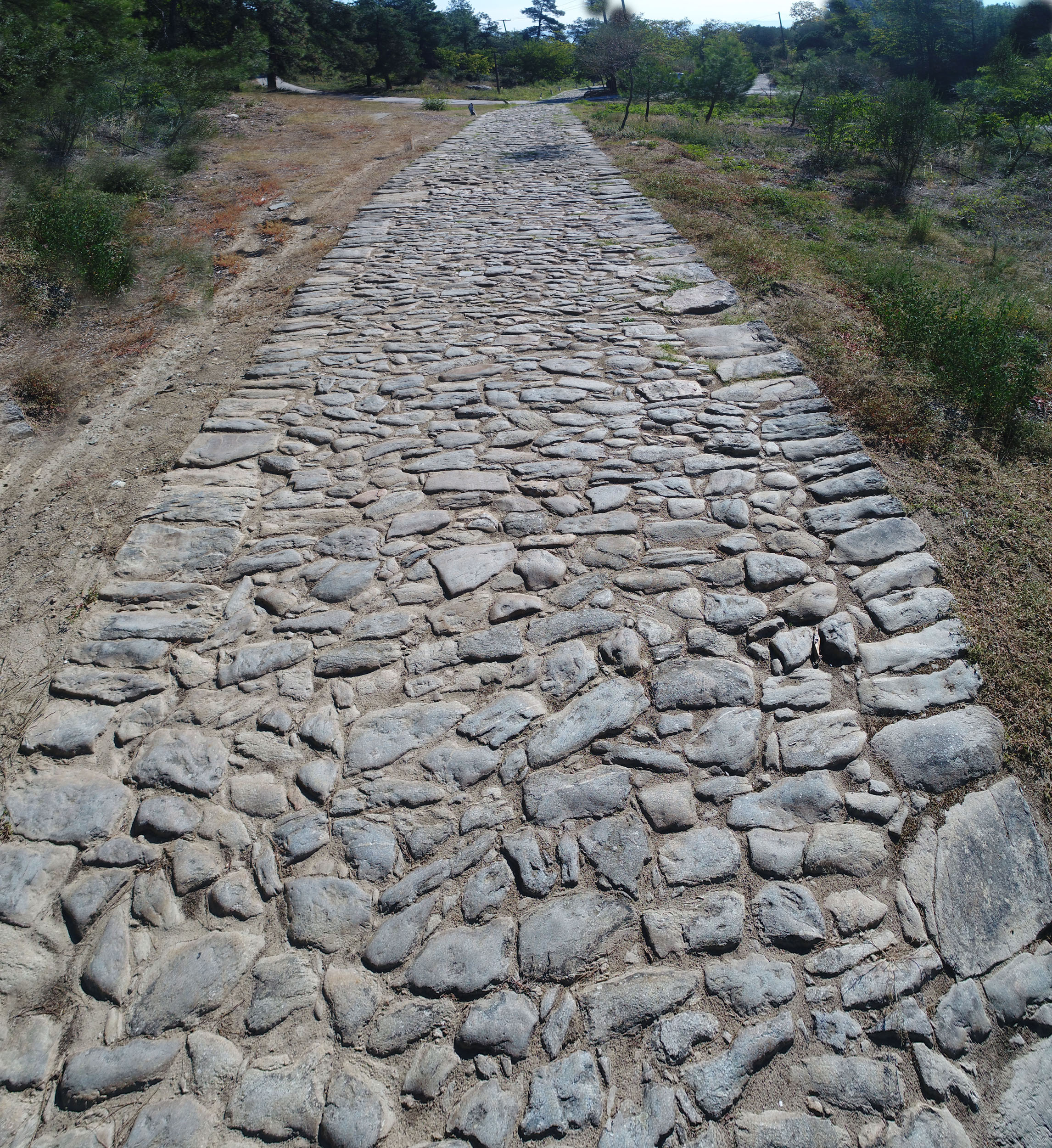
Taken together with the written sources, the archaeological finds also provide important information on the course of the Via Egnatia. The layout of the road and traces of the carriageway are still visible today in many places, as it continued to be used over the centuries, with necessary repairs being made from time to time. The best-preserved remains of the road in Greece are found in the city of Philippi and its environs, between the villages of Stavros and Agios Silas near Kavala, between the villages of Mesti and Komaros in the Zonaia Mountains of Western Thrace, and in various places near Trajanopolis, east of Alexandroupolis. Finally, parts of the ancient road have recently been discovered in the area of Amyntaio in Florina. The construction of the road also included building bridges over rivers and marshes. Typical examples include the group of marble bridges in the plain of Philippi, the impressive six-arch bridge of Kourovo on the River Zygaktis, known from 19th-century photographs, and a smaller two-arch Roman bridge on the Amphipolis–Drama provincial road, which is not visible today. The course of the Via Egnatia is also directly or indirectly associated with archaeological remains of various periods. These include supply stations, inns, fountains and baths, fortresses on riverbanks or in narrow mountain passes, and funerary monuments.
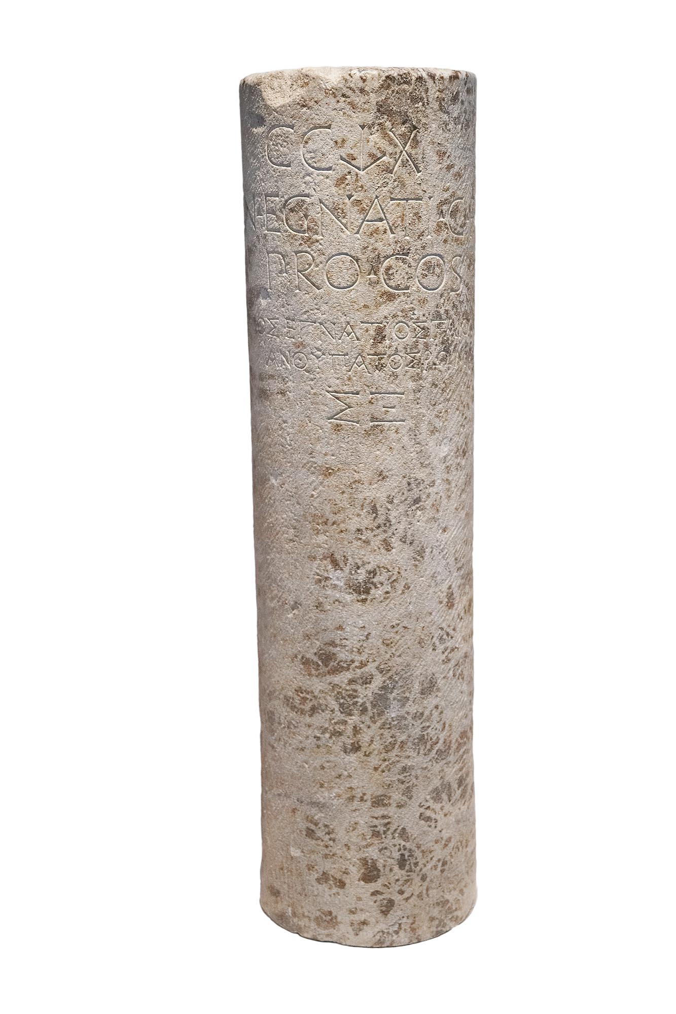
We can follow the course and history of the Via Egnatia using the inscriptions and especially the surviving milestones (miliaria). These are small stone pillars or stelai with a rectangular section which were set up at the sides of the road along the route, providing travellers with information such as the distance from the starting point of the road and the distance between neighbouring cities. Milestones often bore honorific inscriptions in Greek and Latin to emperors who had provided for the repair of sections of the road. The surviving examples found in situ, taken together with the written sources, help us to determine the course of the Via Egnatia.
The main course of the Via Egnatia through the ages based on the written sources and archaeological remains
Examining the archaeological remains alongside the written sources allows us to extract useful conclusions on the construction of the Via Egnatia. Generally speaking, sharp bends and steep gradients were avoided, meaning that in some places the road follows the smoothest rather than the shortest route.
The Via Egnatia started in the west at the two major ports on the Adriatic Sea, in what is now Albania: Apollonia, near the modern port of Vlorë, and Dyrrachium a little further north.
The two branches of the road joined up, and the Via Egnatia, passing through the cities of Scampa (modern Elbasan), Lychnidos (modern Ohrid) and Heraclea Lyncestis (modern Monastir/Bitola), followed a course south of Lake Vegoritida in the Florina area, continued to Edessa and Pella and came to Thessaloniki, one of the most important ports on the Eastern Mediterranean, passing north of the city. This was where the first major section of the road ended. Then, heading south of Lakes Koroneia and Volvi, it reached Apollonia, ran through the narrow Rentina Pass, passed through Amphipolis and, following the northern foothills of Mount Pangaion, reached the port of Neapolis (modern Kavala) via Philippi. From there, following a coastal route, it passed through Akontisma, on the borders of Macedonia and Thrace. It then passed Petropigi and the city of Topeiros on the west bank of the River Nestos. After crossing the Nestos, the Via Egnatia continued along the southern foothills of the Rhodope range and across the plain of Xanthi, avoiding the wide marshes around the lagoon of Lake Vistonis. It then passed through Anastasiopolis, Maximianopolis and the region of Komotini. Via the Zonaia Mountains, which separate the plain of Komotini from the plain of Trajanopolis, it approached the coastal settlement of Zoni and the city of Makri, continuing to Trajanopolis and Bera, before ending at Cypsela on the River Evros. Later, the Via Egnatia was extended to the ancient city of Byzantium, where the Emperor Constantine founded the new capital of the Roman Empire: Constantinople.
According to the historian Procopius (c. 500-565 AD), in the 6th century Justinian paved the last section of the road, from Rhegium to Constantinople: “this king, having paved it with blocks of stone each large enough to load a waggon, has made it altogether easy and painless” (On Buildings 4.8.5). During the Ottoman period, the Via Egnatia, now known as the Sol Kol (“left arm”), with some sections following a different route, was still the main road connecting Constantinople to the Adriatic. It also linked the Aegean Sea and the Balkan hinterland by means of branch roads.
The construction of the road
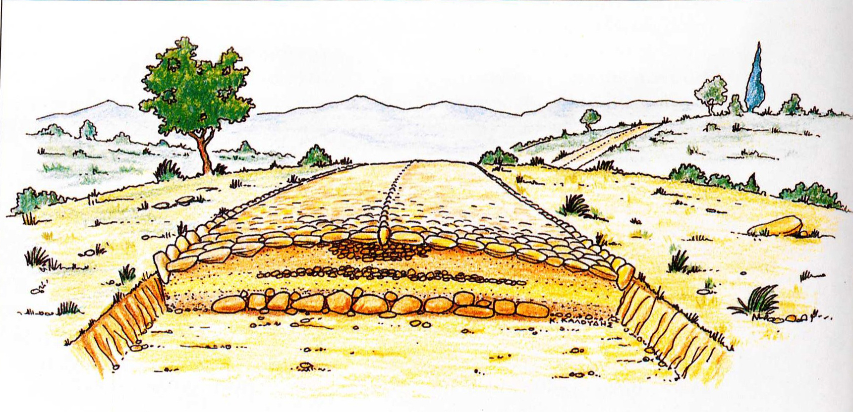
As regards the construction of the Via Egnatia, the description of the Roman roads by the historian Plutarch (c. 45-120 AD) is most informative: “…they had pavements of quarried stone, and substructures of tight-rammed masses of sand. Depressions were filled up, all intersecting torrents or ravines were bridged over, and both sides of the roads were of equal and corresponding height” (Plutarch, Lives, vol. X. Tiberius and Gaius Gracchus, ch. 7, transl. Bernadotte Perrin, Loeb 1921). The construction of the carriageway and foundation of the Via Egnatia is not the same everywhere. Usually, larger kerbstones were set in the sides of the roadbed, while the stones protruded in the centre of the pavement, forming a median strip. In some sections, the carriageway was curved to allow water to drain away easily. The foundation was 0.30 m to over 1 m thick, consisting of successive layers of gravel, clayey soil, sand and large and small stones. The width of the road varied from about 3.5 m to about 10 m. The particularly careful construction of the Via Egnatia is evident in the section of the road discovered near the village of Komaros in the area of the Zonaia Mountains, on the Evros.
Β. THE ROAD AND ITS CITIES THROUGH THE AGES
The Roman Via Egnatia and the cities along its route
The glory days of the Via Egnatia were during the Roman Empire. Its course from the Adriatic to the Evros, through mountain passes, marshes, valleys and rivers, was of vital importance to the life of the regions through which it ran. It contributed decisively to the development of an extensive network of cities, built near rich natural resources and at strategic points on the vertical roads leading to the Balkan hinterland or on the sea routes of the Aegean. These cities served as major hubs in the military, administrative, commercial and economic network of the Roman Empire. They were stations for travellers, merchants and soldiers, embellished with magnificent private and public buildings: houses, theatres, temples and forums, their monumental streets flanked by colonnaded arcades and decorated with elaborate sculptures.
The examples that follow are limited to the cities along the section of the Via Egnatia which runs through the modern territory of Greece.
Thessaloniki, the most important city on the Via Egnatia
The most important city throughout the course of the road’s history was Thessaloniki. From its very foundation, centuries before the Via Egnatia was laid, the city played a leading role as a cultural, religious, administrative, military and commercial centre. In Roman times, Thessaloniki, as the richest and most populous city in Macedonia, was the seat of the province of the same name and the main station of the Via Egnatia, which ran north of the city. One of its oldest surviving milestones was found near Thessaloniki.
Ancient cities acquire renewed splendour: Thessaloniki, Edessa, Apollonia, Amphipolis, Philippi (Neapolis)
Apart from Thessaloniki, many thriving Macedonian cities, even before the time of the Macedonian kings, became busy stopping-places for travellers thanks to the ancient road, acquiring renewed splendour.
The Via Egnatia, which entered what is now Greece via the plain of Florina, is considered to have been one of the factors that contributed to the great commercial and economic prosperity of that ancient city. It also played a part in the rise of the populous city of Petres, near the southwest shore of Lake Petres in the Municipality of Amyntaio. However, despite their commercial and cultural flourishing, both cities were destroyed during the Roman civil wars in the 1st century BC.
West of Thessaloniki, Edessa, already an important city in Hellenistic times, flourished during the Roman period, benefitting from the passage of the Via Egnatia. It was home to one of the provincial mints of the Roman Empire. Four milestones inform us of the city’s contribution to the work on the road and its maintenance costs.
East of Thessaloniki, on the south shore of Lake Volvi, the city of Apollonia also experienced significant development as a station of the Via Egnatia. It had a hostelry for travellers (stabulum) and a well-organised water supply system.
Amphipolis, an Athenian colony since 437 BC, developed into a major political and cultural centre of the ancient world. This was due to its strategic location on the River Strymon and close to the sea, at the crossroads of the Via Egnatia and the roads leading from the Aegean to the hinterland. In Roman times, an important provincial mint operated in the city. The magnificent buildings, the inscriptions and the brilliant works of art that have survived bear witness to its prosperity.
Further east, Philippi, founded by Philip II of Macedonia (359-336 BC) near the rich gold and silver deposits of Mount Pangaion, was laid out according to the Roman model around a central forum and grew into a powerful city. The prosperity of Philippi down the ages (2nd c. BC-6th c. AD) was largely due to the passage of the Via Egnatia through the city. A great arch about 2 km from the west gate of the city walls, at the site now known as Kiemer, was the sign for the weary traveller that he was entering Philippi. Neapolis, the port of Philippi, was equally important. It was here that St Paul the Apostle landed with his companion Silas before entering the city, where he preached the Christian faith, afterwards continuing along the Via Egnatia to Amphipolis, Apollonia and Thessaloniki (49/50 AD).
The Romans found new cities: Pella, Topeiros, Maximianopolis, Trajanopolis
Apart from the cities mentioned above, which lay on the route of the Via Egnatia, the road also gave rise to a series of new important urban centres founded by Roman emperors.
Octavian Augustus (27 BC-19 AD) founded a new Roman city in 30 BC near Pella, the capital of the Macedonian Kingdom: it was named Colonia Pellensis, Colonia Iulia Augusta Pellensis or Colonia Pella. The Via Egnatia, as in the case of Philippi, ran directly through the city.
The Emperor Trajan (98-117 AD) undertook extensive repairs to the road, the memory of which remained alive in later centuries. At the beginning of the 2nd century AD, he also founded Trajanopolis as part of the major administrative reorganisation of the Roman province of Thrace. Although the city has not been systematically excavated, the written sources tell us that it was one of the most important in Thrace due to its proximity to the Via Egnatia, as well as being a renowned centre of healing associated with the cult of Asclepius. Topeiros, a city founded a little earlier on the banks of the River Nestos, was strengthened in Trajan’s time. Maximianopolis was founded around the early 4th century, becoming one of the most important urban centres of the region.
Cities in decline: Abdera, Maroneia, Zone
Following the construction of the Via Egnatia, coastal towns such as Abdera and Maroneia found themselves on the opposite course. They declined and shrank because the new main road axis shifted commercial activity from the coast to the hinterland of Thrace.
4th-6th centuries (strengthening the defences – the changing face of the cities) Strengthening the defences
From the 3rd century, when insecurity on the Danubian borders of the Roman Empire began to increase, the main concern of the emperors with respect to the Via Egnatia was to strengthen the defences of the cities along its course. In the second half of the 3rd century, the threat of Gothic raids led to the rapid repair of the walls of Edessa using spolia, mainly taken from the funerary monuments of its cemeteries. Several decades later, the foundation by Constantine I of Constantinople, the new capital, which the umbilical cord of the Via Egnatia connected to Rome via the Adriatic ports, made such precautions even more necessary.
Theodosius the Great (379-395) saw to the strengthening of the imposing walls of Thessaloniki, in order to deal with the Gothic danger effectively. The importance of this work, and the vitality and dynamism of the city, are confirmed by its successful handling of repeated enemy raids in later centuries, too. Rentina, the city at the entrance to the Macedonian Tempi, the only pass leading from Macedonia to Thrace, was fortified in the mid-4th century. In the 6th century, during the reign of Justinian, the walls were reinforced and a large cistern was built in the centre of the city to provide drinking water. Repair phases of the same period are also discernible in the walls of Neapolis, modern Kavala. Justinian I (527-565), as part of his extensive fortification-building work in Thrace due to the constant Slavic invasions, repaired the walls of Maximianopolis and constructed a coastal wall and a large aqueduct wall at Anastasiopolis, a city founded a few years earlier by the Emperor Anastasius I (491-518) in the bight of Lake Vistonis. Immediately after its siege and destruction by the Slavs in 549-550 AD, the populous city of Topeiros, which controlled the crossing of the River Nestos, was reinforced with strong fortifications, also on Justinian’s initiative.
The changing face of the cities
Alongside the imperial work on strengthening the defences of the large urban centres along the Via Egnatia, during the same period, from the 4th century onwards, these cities were transformed into Christian centres with the construction of monumental churches and public buildings serving the needs of the new religion. In Thessaloniki, a city identified with the cult of St Demetrios, many churches were built for the faithful, both residents and visitors. In Amphipolis, the seat of an episcopal see from the 5th century onwards, four basilicas and a rotunda were constructed. These buildings were adorned with magnificent architectural sculptures, while remarkable mosaic floors have been preserved in three of the basilicas. In Philippi, numerous Christian churches were erected on the site of Roman buildings, their monumental dimensions imposing themselves on the urban space, while their rich decoration echoes the art of Constantinople.
7th century
In the 7th century, the presence of the Avars and the settlement of the Slavs in the Balkans rendered travel along the Via Egnatia unsafe. The consequent increase in sea travel led to a fall in traffic on the western section of the road from Dyrrachium to Thessaloniki, a drop which also affected the cities located there. Once-flourishing urban centres such as Edessa and Pella gradually fell into decline. The eastern section of the Via Egnatia remained open during this period; even there, however, the raids of the Slavs and later the Bulgarians led to the gradual shrinking of Philippi and Amphipolis.
From the 8th century onwards
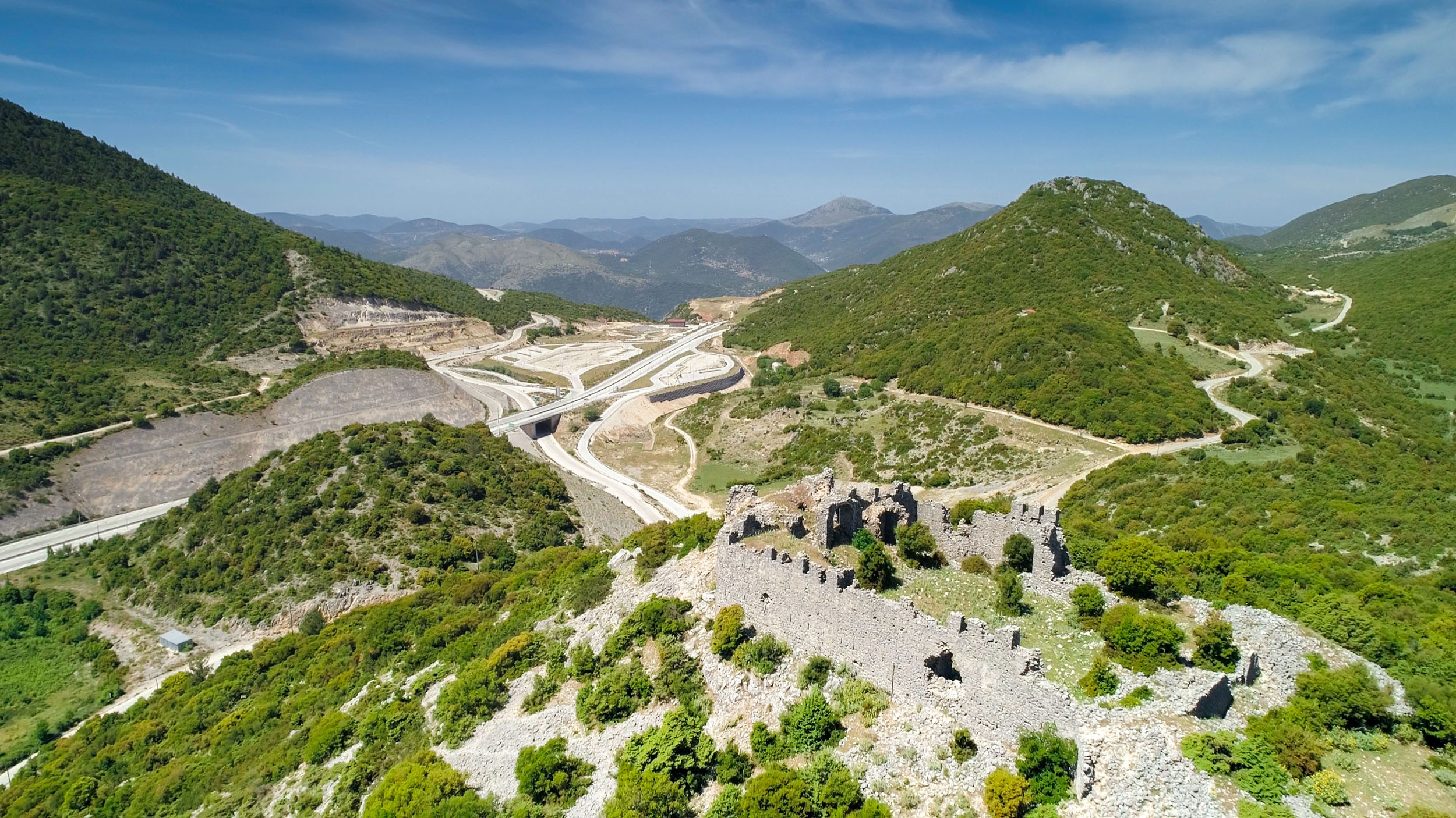
This picture of the Via Egnatia remained unchanged in the following centuries. The road was now divided into the eastern section, which survived, and the western section, which fell into disuse. From the end of the 8th to the 12th century, the less vulnerable eastern part of the road, which ensured communication by land between Thessaloniki and Constantinople, played an important military and economic role, although its operation was affected by historical events. It was only on the dissolution of the extensive Bulgarian state of Tsar Samuel (997-1014) by Basil II (976-1025) in 1018, and the establishment of Byzantine rule in Macedonia and almost the whole of the Balkan Peninsula, that control and security were achieved along the whole length of the Via Egnatia from Constantinople to Dyrrachium. The castles close to the road, such as the Castle of Moglena near Edessa and Kale Castle in Amyntaio, Florina, also served to protect it.
The Sack of Constantinople by the Crusaders in 1204 was of crucial importance to the fate of the Via Egnatia and the cities along its course. The Crusader troops used the great Balkan road to reach the Byzantine capital, occupying the lands along the way. The Macedonian territories were gradually recovered by the Byzantines, as was Constantinople itself in 1261. At the same time, control was restored over the eastern section of the road, while the western section was completely abandoned. With the civil wars of the 14th century, the conquest of most of Macedonia by Stefan Uroš IV Dušan’s Serbs, and the Ottoman expansion, the territories of Macedonia and Thrace were fragmented. Unified control of the Via Egnatia was lost, as the road was broken up into pieces controlled by local rulers, leading to its decline.
The information provided by the sources and archaeological data of the Middle and Late Byzantine periods highlights the vivid presence of the cities on the Via Egnatia. Thessaloniki retained its power and prestige, remaining the most important urban centre along its course. Other cities, such as Anastasiopolis-Peritheorio and Koumoutzena (modern Komotini), were centres or bases of successive military operations, serving to protect and control the surrounding regions. Castles such as those of Avantas and Potamos in the southeastern foothills of the Rhodope Mountains played a similar role. Other important centres were Bera (modern Feres), with the famous Monastery of Panagia Kosmosoteira, Trajanopolis and Maximianopolis/Mosynopolis, which hosted powerful emperors, Xantheia and Christopolis (modern Kavala) with their strong walls, Makri with its important port, the polichnion (small town) of Drama, Rentina, a notable polichnion with several hundred inhabitants and active workshops, Edessa/Vodena, a key city for the control of Central Macedonia along the western section of the Via Egnatia, and cities close to the road, such as Kastoria and Veria. Travellers, military contingents, merchants, artists and pilgrims could find accommodation there or stay overnight. The cities of the Via Egnatia were vital hubs on the routes to the nearby major monastic centres, such as Mount Athos, Mount Papikion and the Monastery of St John the Baptist (Timios Prodromos) in Serres.
For the convenience of all travellers, the towns and cities on the Via Egnatia had an integrated service system with shops, taverns, baths and inns. Few remains of these buildings survive to our day. One of the many bathhouses of Thessaloniki has been preserved on the edge of the Upper Town. Another bathhouse has come to light outside the walls of Drama, at the south end of the old town. The sources tell us that the commercial heart of Serres was the city market, the “Emporion”. Shops and workshops were concentrated near the west gate in the walls, the “Royal Gate” or “Market Gate”, and along the main street leading inwards from it. The sources also refer to the magipeia (bakeries) of Serres and a tavern.
Ottoman period
The Ottomans, the great power that succeeded the Byzantine Empire, conquered Western Thrace and Eastern Macedonia in the 1360s and 1370s, and by the early 16th century had established their presence as far as Dyrrachium. They immediately grasped the strategic and economic importance of the great road that crossed the Balkans from East to West. Thus the Via Egnatia came back into use, acquiring a new name: Sol Kol (“left arm”). For those travelling through the territories of the Ottoman Empire in a single borderless region, the road would henceforth be a fixed reference point. At the stations of the Via Egnatia the Ottomans constructed aqueducts, imposing bridges and buildings to serve the official postal service of the central administration (ulaķ), the equivalent of the Roman cursus publicus. Travellers and merchants were served by the hans, caravanserais, fountains, hammams and bedestens (covered markets) they found on their way. One of the earliest examples of such buildings is the “Hana”, the han of Gazi Evrenos Bey in Trajanopolis. The Ottomans also built important religious foundations, imposing mosques, medreses (madrasas) and imârets. On the Via Egnatia, west of Lake Vistonis and near the Byzantine Anastasiopolis/Peritheorion, was erected the Türbe of Kütüklü Baba. It was located on the route of large numbers of Muslim pilgrims, who contributed decisively to its great prosperity.
Thessaloniki remained the most important centre of the region, but it was significantly altered by the construction of large public and religious buildings and the conversion of Christian churches into Muslim mosques. The city’s cosmopolitan atmosphere was enhanced by the merchants and travellers who stayed and replenished their supplies at the many hans whose numbers attest to the high commercial traffic of the city. The Ottoman traveller Evliya Çelebi mentions 16 hans and an unknown number of caravanserais in Thessaloniki, while 87 hans are recorded in the city in the tax registers of 1906.
Cities such as Kavala, Drama, Serres and Edessa/Vodena, already notable in the Byzantine period, continued to flourish, while others, such as Gümürcine (modern Komotini) and Ferecik (Byzantine Bera), developed into important Ottoman administrative centres. At the same time, new towns and cities were founded along the Via Egnatia: Genisea south of Xanthi, the regional Ottoman administrative seat and an important commercial centre, where the agricultural products of the fertile plain, mainly rice and cereals and, later, high-quality tobacco, were gathered; the lakeside town of Pazarouda on Lake Volvi, which boasted a great bazaar, and where a hammam, a mosque and a han are preserved to this day; Giannitsa, one of the most important military, economic, religious and cultural centres of the Balkan Peninsula; and Florina, the seat of a sancak in the 15th century, in a key position on the road connecting Thessaloniki to Monastir.
The Ottoman Via Egnatia was also extremely important to urban centres that were not actually on its route. Caravans set out from cities such as Ioannina, Metsovo, Siatista, Kozani, Grevena and Kastoria, met the Via Egnatia and continued on their way to the markets of the Balkans and Europe. All in all, the Via Egnatia, combined with other main roads such as that connecting Constantinople with Central Europe and those linking Thessaloniki with Belgrade, Vienna and Trieste, was the main axis of the Balkan terrestrial road network during the Ottoman period, as it had been in the past and continued to be up to the modern period.
Towards the end of the 19th century, the route of the Via Egnatia was followed by a faster and safer means of transport, the railway. In 1869, the Austrian company of Baron Maurice de Hirsch was accorded the privilege by the Ottoman government of constructing and operating the railway line between Thessaloniki and Constantinople/Istanbul, the Jonction Salonique–Constantinople. It was in the context of this project that a new port city, an important land and sea hub, came to the fore: Dedeağaç, present-day Alexandroupolis. The city was probably built near the site of the Roman station of the Via Egnatia called Timpiro or Mutatio ad Unimpara.
A modern road with a long history
Today, following the dissolution of the Ottoman Empire about a century ago and with the constant shifting of borders in the Balkans in the 20th century, the ancient Via Egnatia runs through four countries: Albania, North Macedonia, Greece and Turkey.
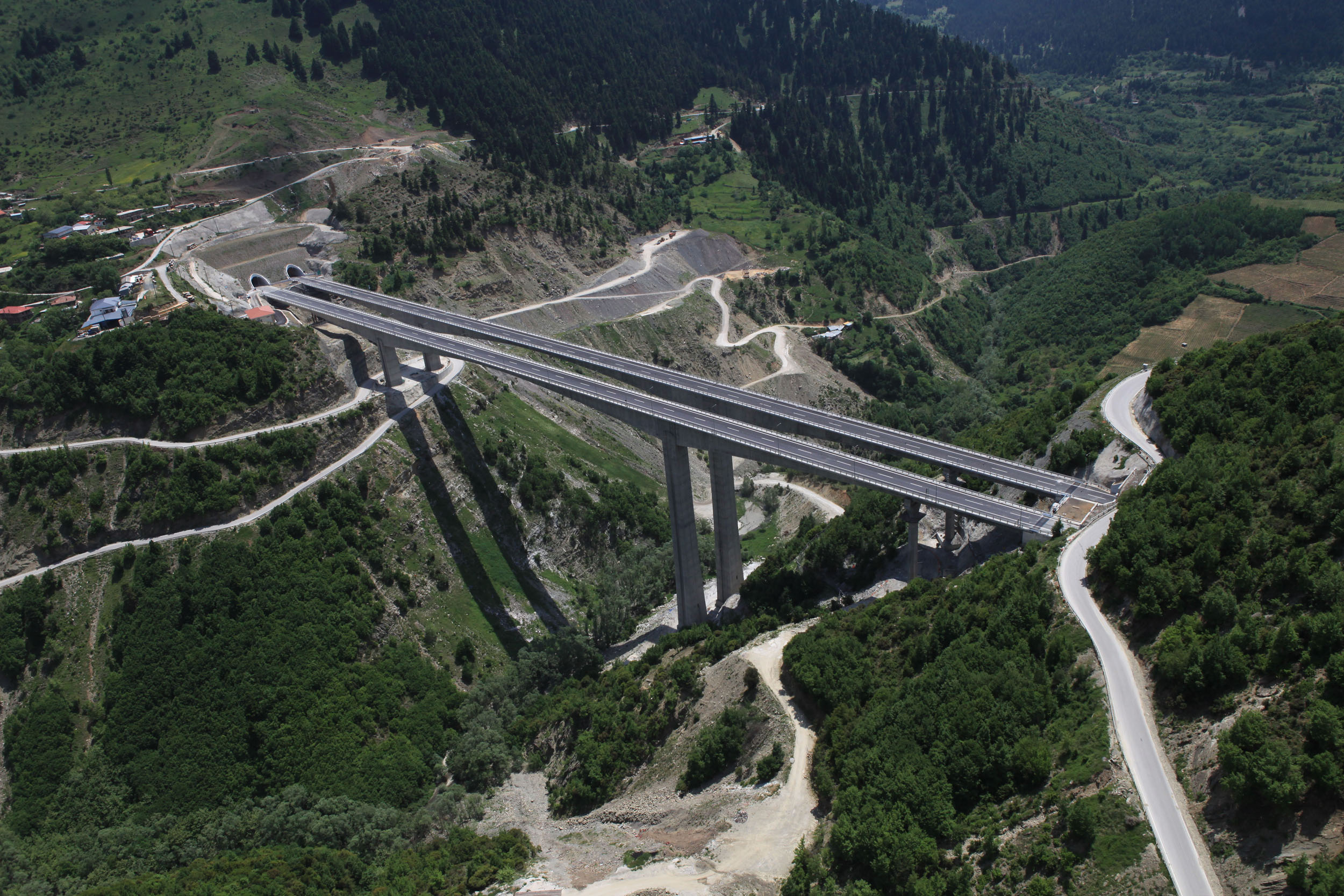
The modern Egnatia Motorway, a key part of the present-day road network, starts at the port of Igoumenitsa, the closest port in Greece to Italy and the Adriatic Sea. Including its western branch, which does not coincide with the ancient road, it connects Epirus, Macedonia and Thrace, and some of the most beautiful and fascinating cities and regions of Greece, such as Ioannina, Souli, Metsovo, Grevena and Kozani. Although its course does not perfectly match that of the Roman road, the modern Egnatia Motorway, like the ancient Via Egnatia, functions as a link between people and places, and also as a means of reaching sites with a rich history and age-old culture.
C. INCESSANT MOVEMENT OF PEOPLE, GOODS AND ARTISTIC CURRENTS
For over two thousand years, covering the lifetime of three empires, the Roman, Byzantine and Ottoman, the Via Egnatia was one of the main channels along which people, goods and ideas moved, transforming the cities connected to it into places of intellectual and artistic ferment.
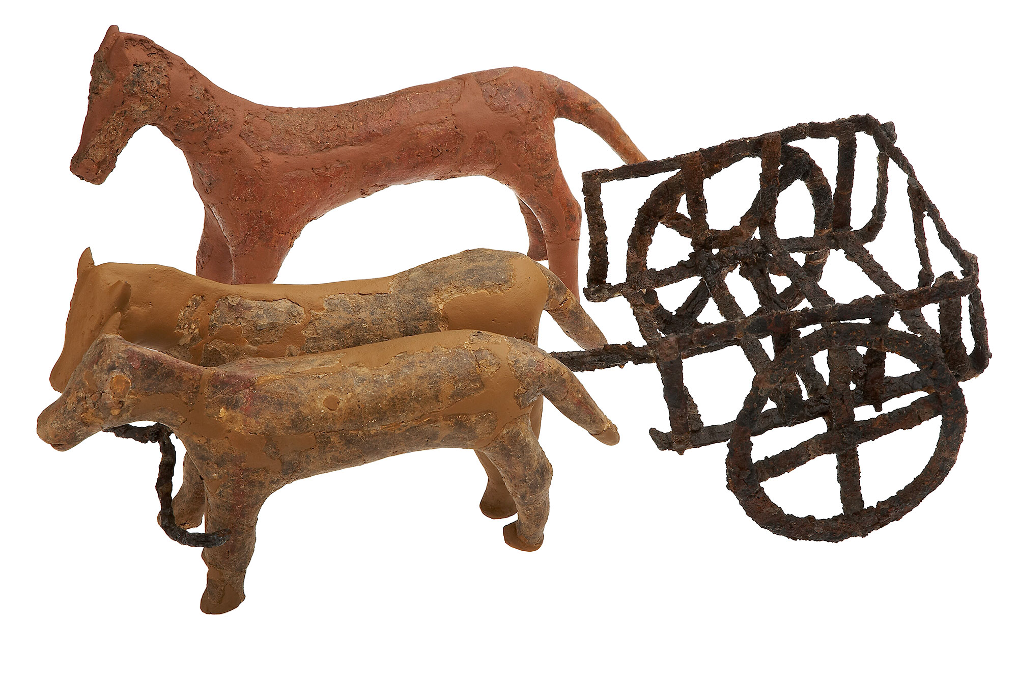
During the Roman period, the main means of transportation for people and goods on built roads such as the Via Egnatia was the carriage. This wheeled vehicle was made of wood and metal, open or covered depending on its intended use. It had two or four spoked wheels, a box-shaped body and a long wooden shaft connecting the front of the carriage to the yoke, to which were attached the draught animals: oxen, horses or mules. As with all Roman roads, traffic on the Via Egnatia drove on the left, a practice still seen today in English-speaking countries. This meant that the carriage-drivers, who held the reins in their right hand and the whip in their left, did not injure those passing in the opposite direction.
During Byzantine and Ottoman times, the use of carriages for overland transport was significantly reduced, because they could not move along rough roads and through narrow passes. The chief mode of transport was pack animals, mainly horses or mules or even camels, with goods carried in packs or in panniers tied to the animals’ backs. However, merchants carrying large loads over long distances continued to use smaller or larger carts and carriages on long roads such as the Via Egnatia. In addition to the simple araba (cart), there was also the caruta (waggon), a four-wheeled horse-drawn vehicle, and the larger and more powerful taliga. A striking picture on the Via Egnatia was painted by the caravans, large trains of waggons and animals, which slowly made their way along the road.
It was not only merchants who travelled on the Via Egnatia. The road was also used by craftsmen: masons, carpenters, sculptors, painters, mosaicists, gold- and silversmiths, coppersmiths and weavers. They crossed paths with pilgrims, sightseers and other travellers. They all rested at the way stations and moved from town to town. Thus, everything was transported along the Via Egnatia: all kinds of goods, from foodstuffs and raw materials to pottery, glassware, textiles, leather, coins, miniature works of art and icons. Experiences, ideas and knowledge travelled with them.
This uninterrupted artistic and cultural connection through the Via Egnatia is evident from the great number of surviving monuments, ancient, Byzantine and Ottoman, many of them masterpieces of art and architecture. The Roman and Early Christian cities along the Via Egnatia, with their impressive architectural complexes and magnificent sculptural decoration, experienced intense building activity and enjoyed close artistic ties with Rome and later with Constantinople. The similarities in the style and iconography of the elaborate floor mosaics in Amphipolis, Arethusa near Lake Volvi, Thessaloniki, and also further north, from Heraclea Lyncestis to Dyrrachium, are evidence of the movement of notable artists and artisans along the route, their workshops undertaking the decoration of the large public and private buildings of the cities.
Frescoes of unparalleled beauty in the Byzantine monuments of Thessaloniki, Kastoria, Veria, Mount Athos, the Prespa region and further north, in Ohrid and Serbian cities, testify to the mobility of artistic workshops and the spread of artistic currents from the two major centres, Constantinople and Thessaloniki, to the wider Balkan area, and to the artistic connection of the regions via the Via Egnatia. During the Ottoman period, the groups of itinerant artists who wandered throughout the Balkan part of the Ottoman Empire, shaping the common aesthetic of the Orthodox Christians of southeast Europe, certainly used the Via Egnatia. The painters from the villages of Linotopi and Grammosta in Kastoria, who travelled around Epirus, Macedonia, and further south, in Central Greece, are a typical example. An earlier example is that of the 16th-century painter Onouphrios of Berat, whose works are found in Albania, Serbia and Kastoria.
The intense mobility and commercial activity of Greek merchants is also noteworthy, especially from the 18th century onwards. They travelled from Epirus and Macedonia along the main roads of the Balkans to the major cities of the West. On their return, they brought with them new ideas that assisted the development of the intellectual life of their homeland. This love of the arts and contact with the Western world via the trade routes is evident in the wealthy mansions of Kozani, Siatista, Kastoria and Veria.
For centuries, the Via Egnatia brought people, ideas, languages, religions, musical traditions, dances and culinary traditions together in a creative osmosis, shaping a rich tangible and intangible cultural heritage. Just as in antiquity, the modern Egnatia continues to inspire travellers, conversing with the ancient road and connecting modern towns, cities and regions with a long history and a living culture.